Opportunity Route Map |

  |
Opportunity Route Map |
 Aug 15 2006, 03:03 PM Aug 15 2006, 03:03 PM
Post
#1771
|
|
 Senior Member  Group: Moderator Posts: 3431 Joined: 11-August 04 From: USA Member No.: 98 |
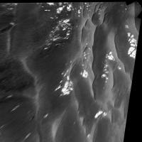
QUOTE (djellison @ Aug 15 2006, 02:30 PM)  Perhaps characterise the dune material in this region before spending a month or two driving on it toward Vic. Sounds reasonable to me. I'm guessing this is our first contact with the annulus material so they want to check it out. Those of us who were dreaming of a rapid transit toward Victoria will probably need to adjust our expectations somewhat, but once we lay the groundwork here I'm sure we'll be speeding along. Here's a equirectangular projection of the three Navcam frames in case Phil or someone wants to turn it into a polar for mapping purposes. North is at center. |
 |
 
|
|
Aug 15 2006, 03:26 PM
Post
#1772
|
|
 Member Group: Members Posts: 133 Joined: 3-June 06 From: the jungle of Nool Member No.: 799 |
QUOTE (Phil Stooke @ Aug 15 2006, 10:21 AM) They said they wanted to look at one of the banded drifts, and this might be the last chance. Phil 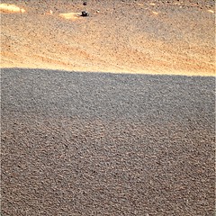 Yes, that seems to be the plan. Closer measurments of a small rock in the closeup Navcams of this area on sols 908 and 909 showed a movement of 1.86 +/- 0.03 meters towards this area. |
|
|
|
|
Aug 15 2006, 04:05 PM
Post
#1773
|
|||
 Senior Member Group: Members Posts: 2492 Joined: 15-January 05 From: center Italy Member No.: 150 |
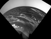
QUOTE (mhoward @ Aug 15 2006, 03:03 PM) Here's a equirectangular projection of the three Navcam frames in case Phil or someone wants to turn it into a polar for mapping purposes. North is at center. Vertical+Polar projections.
(Michael, if you regularly publish these equirectangular projections, I will be happy to reproject them!  ) )
-------------------- I always think before posting! - Marco -
|
||
|
|
|
||
|
Aug 15 2006, 04:21 PM
Post
#1774
|
|
|
Senior Member Group: Moderator Posts: 3431 Joined: 11-August 04 From: USA Member No.: 98 |
QUOTE (dilo @ Aug 15 2006, 04:05 PM) (Michael, if you regularly publish these equirectangular projections, I will be happy to reproject them! )Sure thing. They're pretty easy for me to produce now, and they should be fairly accurate as I'm feeding the actual camera pointing information to PTGui. |
|
|
|
|
Aug 15 2006, 04:26 PM
Post
#1775
|
|
|
Senior Member Group: Members Posts: 1636 Joined: 9-May 05 From: Lima, Peru Member No.: 385 |
QUOTE (hortonheardawho @ Aug 15 2006, 10:26 AM) Yes, that seems to be the plan. Closer measurments of a small rock in the closeup Navcams of this area on sols 908 and 909 showed a movement to 1.86 +/- 0.03 meters towards this area. Thanks hortonheardawho's picture. That picture has brough me the attention. Its minor-surface is nothing flat but it presents small underlines and the color of every grain is rather homogeneous except to few dark points (another kind of pulverized rock). It looked like that surface has undergone by very thin or very small humidity. Rodolfo |
|
|
|
|
Aug 16 2006, 12:40 AM
Post
#1776
|
||
|
Solar System Cartographer Group: Members Posts: 10145 Joined: 5-April 05 From: Canada Member No.: 227 |
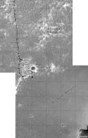
Latest map update.
Phil
-------------------- ... because the Solar System ain't gonna map itself.
Also to be found posting similar content on https://mastodon.social/@PhilStooke NOTE: everything created by me which I post on UMSF is considered to be in the public domain (NOT CC, public domain) |
|
|
|
|
|
|
Aug 17 2006, 12:52 PM
Post
#1777
|
|
|
Senior Member Group: Moderator Posts: 4279 Joined: 19-April 05 From: .br at .es Member No.: 253 |
QUOTE (algorimancer @ Aug 14 2006, 08:05 PM) Worst case, we ought to be able to triangulate off of the Twin Peaks and Hawking Rock throughout much of the route. Later there should be ejecta blocks from Epsilon that will be helpful, and I'd expect some Vicky features as well. I was thinking on a similar approach using Delta and Epsilon as references; I think more the features better the triangulation. But I would use this method as a way to periodically adjust the route. I think for most of the way on this last part of the route I'll use the rover's position data from the pancam data tracking web to plot the path and from time to time (e.g. each 200m) do a triangulation to see if such path needs to be corrected. |
|
|
|
|
Aug 18 2006, 08:53 PM
Post
#1778
|
||
|
Senior Member Group: Moderator Posts: 4279 Joined: 19-April 05 From: .br at .es Member No.: 253 |
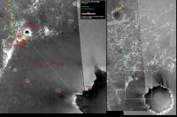
Ok, here we go again. My route map, updated to sol 912.
PS: This latest position is derived from a 55m drive on a heading about 14º to the left (east) of "Gamma". |
|
|
|
|
|
|
Aug 18 2006, 09:18 PM
Post
#1779
|
||
 Member Group: Members Posts: 656 Joined: 20-April 05 From: League City, Texas Member No.: 285 |
QUOTE (Tesheiner @ Aug 18 2006, 03:53 PM) Ok, here we go again. My route map, updated to sol 912.
PS: This latest position is derived from a 55m drive on a heading about 14º to the left (east) of "Gamma". Love the labeling  I think that sometime in the next few days we ought to be able to firmly tie Hawking Rock to a feature on the C-Proto image, I have strong suspicions already. I noticed today that it is already spanning about 3 pixels in height from the current position. Seems big for a meteorite, but not inconceivable. Could be the Monolith I suppose, but seems too pointy I think that sometime in the next few days we ought to be able to firmly tie Hawking Rock to a feature on the C-Proto image, I have strong suspicions already. I noticed today that it is already spanning about 3 pixels in height from the current position. Seems big for a meteorite, but not inconceivable. Could be the Monolith I suppose, but seems too pointy
|
|
|
|
|
|
|
Aug 20 2006, 02:07 PM
Post
#1780
|
||
|
Senior Member Group: Moderator Posts: 4279 Joined: 19-April 05 From: .br at .es Member No.: 253 |
QUOTE (algorimancer @ Aug 18 2006, 11:18 PM) I think that sometime in the next few days we ought to be able to firmly tie Hawking Rock to a feature on the C-Proto image You should be quick or Oppy will run by that rock before we can locate it!  Updated route map for sol 914.
|
|
|
|
|
|
|
Aug 20 2006, 03:03 PM
Post
#1781
|
|
 Dublin Correspondent Group: Admin Posts: 1799 Joined: 28-March 05 From: Celbridge, Ireland Member No.: 220 |
QUOTE (Tesheiner @ Aug 20 2006, 03:07 PM) You should be quick or Oppy will run by that rock before we can locate it! What's the Martian for Va Va Voom? |
|
|
|
|
Aug 20 2006, 04:57 PM
Post
#1782
|
|
|
Senior Member Group: Members Posts: 2918 Joined: 14-February 06 From: Very close to the Pyrénées Mountains (France) Member No.: 682 |
QUOTE (Tesheiner @ Aug 20 2006, 04:07 PM) Updated route map for sol 914. Oppy is closing up to the center of the image very quickly. I'm looking forward to see your route where the center of the image will be the center of Victoria. BTW, will you also keep the context image? Just wondering, I'll know very soon for sure
-------------------- |
|
|
|
|
Aug 20 2006, 06:04 PM
Post
#1783
|
||
|
Solar System Cartographer Group: Members Posts: 10145 Joined: 5-April 05 From: Canada Member No.: 227 |
Here is the latest version of my total route map. It consists of 15 squares, each 500 m across, with a grid (based on a map-projected MOC image) at 100 m spacing. The origin of the grid is the lander. It incorporates numerous corrections to versions I have posted before. Each square (at full size) will be a separate map in a future project.
Phil
-------------------- ... because the Solar System ain't gonna map itself.
Also to be found posting similar content on https://mastodon.social/@PhilStooke NOTE: everything created by me which I post on UMSF is considered to be in the public domain (NOT CC, public domain) |
|
|
|
|
|
|
Aug 20 2006, 06:10 PM
Post
#1784
|
|
|
Solar System Cartographer Group: Members Posts: 10145 Joined: 5-April 05 From: Canada Member No.: 227 |
Helvick: "What's the Martian for Va Va Voom?"
Hubba Hubba, I think. Phil -------------------- ... because the Solar System ain't gonna map itself.
Also to be found posting similar content on https://mastodon.social/@PhilStooke NOTE: everything created by me which I post on UMSF is considered to be in the public domain (NOT CC, public domain) |
|
|
|
|
Aug 20 2006, 07:07 PM
Post
#1785
|
|
 Senior Member Group: Members Posts: 4246 Joined: 17-January 05 Member No.: 152 |
A drive to Vicky via Epsilon will help us keep our bearings and will give us a peek at that ancient degraded crater too. Epsilon crater here we come!
|
|
|
|
|

|
Lo-Fi Version | Time is now: 18th April 2024 - 09:25 AM |
|
RULES AND GUIDELINES Please read the Forum Rules and Guidelines before posting. IMAGE COPYRIGHT |
OPINIONS AND MODERATION Opinions expressed on UnmannedSpaceflight.com are those of the individual posters and do not necessarily reflect the opinions of UnmannedSpaceflight.com or The Planetary Society. The all-volunteer UnmannedSpaceflight.com moderation team is wholly independent of The Planetary Society. The Planetary Society has no influence over decisions made by the UnmannedSpaceflight.com moderators. |
SUPPORT THE FORUM Unmannedspaceflight.com is funded by the Planetary Society. Please consider supporting our work and many other projects by donating to the Society or becoming a member. |
|