Cape York - The "Lakelands", Starting sol 2703 |

  |
Cape York - The "Lakelands", Starting sol 2703 |
 Oct 2 2011, 03:51 PM Oct 2 2011, 03:51 PM
Post
#181
|
|
 Senior Member  Group: Moderator Posts: 3431 Joined: 11-August 04 From: USA Member No.: 98 |
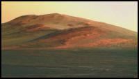
Can't wait to get over that rise.
Pancam L2R2 anaglyph Pancam L2 360x32 degree panorama, sols 2715-2732 |
 |
 
|
| Guest_Bobby_* |
Oct 2 2011, 03:56 PM
Post
#182
|
|
Guests |
Short Question regarding Coloring of Photos.
Is there any site out there that shows how Nasa or JPL converts the Black and White images into true Color Images? Thanks. |
|
|
|
|
Oct 2 2011, 04:21 PM
Post
#183
|
|
|
Founder Group: Chairman Posts: 14431 Joined: 8-February 04 Member No.: 1 |
From the Cornell Pancam team with multiple references:
http://pancam.astro.cornell.edu/pancam_ins...projects_1.html That's as close to " how Nasa or JPL converts the Black and White images into true Color Images" as you will find. This is more of a laypersons discussion of it: http://www.highmars.org/niac/education/mer/ |
|
|
|
|
Oct 3 2011, 02:34 AM
Post
#184
|
|
 Senior Member Group: Members Posts: 4246 Joined: 17-January 05 Member No.: 152 |
From the latest PS update, some news about Chester Lake:
QUOTE "It has sort of a basaltic composition," Squyres continued. "It does not have a zinc enrichment like we saw at [Tisdale 2], so we're stating to think the zinc at the previous location might have been a coating instead of something deep in the rock. We're still thinking about that. It's a work in progress. We're still taking data." And discussion about the coming winter: QUOTE "There is a fair amount of dust on our solar arrays and it looks like this winter Opportunity will have a more difficult time of it than she has ever had in the past and it is of concern to us," elaborated Nelson. "We've put together a Winter Planning Team to begin gathering data." QUOTE If Opportunity can achieve a 15-degree slope to the north at least through the worst of winter, she could continue to move every day. "Less than that, then we might have to park the rover for a period of time," he said. QUOTE "We are looking at sites where we would leave Cape York and dash south and cross Botany Bay to places like Nobby's Head or even further," said Callas. "But we're still very early in this process and we really don't have the information yet to make these decisions. We are gathering that information now."
|
|
|
|
|
Oct 3 2011, 09:55 AM
Post
#185
|
||
 Senior Member Group: Members Posts: 1079 Joined: 19-February 05 From: Close to Meudon Observatory in France Member No.: 172 |
QUOTE (fredk @ Oct 3 2011, 04:34 AM)  "We are looking at sites where we would leave Cape York and dash south and cross Botany Bay to places like Nobby's Head or even further," said Callas. "But we're still very early in this process and we really don't have the information yet to make these decisions. We are gathering that information now."  Well : let's have a nice look at Cape Tribulation : here is a quick merge between super hi-res Well : let's have a nice look at Cape Tribulation : here is a quick merge between super hi-reshttp://pancam.astro.cornell.edu/pancam_ins...superres_4x.tif image and color image from Sol 2721... Some more geological delights to come... Yum ! Yum ! 
|
|
|
|
|
|
|
Oct 3 2011, 06:14 PM
Post
#186
|
|
 Member Group: Members Posts: 754 Joined: 9-February 07 Member No.: 1700 |
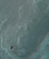
Question about an image posted in the 30 Sept MER Update from the Planetary Society: what is the feature running from top left to bottom right? If it's not the rim of Endeavour, is it another crater rim, or some kind of lava flow? A shoreline from the watery past?
Apologies in advance if this has been discussed; searching continues to baffle!  
|
|
|
|
|
Oct 3 2011, 06:57 PM
Post
#187
|
||
|
Member Group: Members Posts: 111 Joined: 14-March 05 From: Vastitas Borealis Member No.: 193 |
And as an accompaniment with the above image, a slightly enlarged (120%) and sharpened anaglyph of the southern half of Cape York, all the way to the phyllosilicate crater - complete with Oppy! (Hopefully answering brellis's question too.
)
Attached thumbnail(s)
|
|
|
|
|
|
|
Oct 3 2011, 06:58 PM
Post
#188
|
|
|
Member Group: Members Posts: 754 Joined: 9-February 07 Member No.: 1700 |
Sifting through the wonderful PS update, it seems to be the SW edge of Cape York. Correct?
edit: thanks wiggle!
|
|
|
|
|
Oct 3 2011, 07:11 PM
Post
#189
|
|
|
Member Group: Members Posts: 754 Joined: 9-February 07 Member No.: 1700 |
Another question: is the bright feature in the distance in this pic the eastern edge of Cape York? Why is it bright? Okay, that was two questions!
edit: I referred to it as the Ventura Freeway in the context of a crater the size of the San Fernando Valley, CA. A bright feature running through the middle-right of the pic ADMIN EDIT : Removed embedding of image - it was 4500 pixels across. Use a link and/or thumbnail http://www.db-prods.net/marsroversimages/O...2681-pancam.jpg |
|
|
|
|
Oct 3 2011, 10:55 PM
Post
#190
|
|
|
Senior Member Group: Members Posts: 1043 Joined: 17-February 09 Member No.: 4605 |
QUOTE (brellis @ Oct 3 2011, 06:14 PM) ....what is the feature running from top left to bottom right? ..... It's a terrace or bench around CY and other rim remnants that seems to delineate the change between the hematite concretion bearing sulphate sediments and the old rim material. We crossed the bench with some haste and currently can only hypothesise from our armchairs over the underlying cause. |
|
|
|
|
Oct 4 2011, 02:00 AM
Post
#191
|
|
 Member Group: Members Posts: 399 Joined: 28-August 07 From: San Francisco Member No.: 3511 |
The "Ventura Freeway" from your link appears to be a stretch of bright dunes skirting Endeavour's enormous mound.
Google Mars suggests these dunes are some 3km in the distance... -------------------- 'She drove until the wheels fell off...'
|
|
|
|
|
Oct 4 2011, 03:04 AM
Post
#192
|
|
 Senior Member Group: Admin Posts: 4763 Joined: 15-March 05 From: Glendale, AZ Member No.: 197 |
QUOTE (brellis @ Oct 3 2011, 12:11 PM) I referred to it as the Ventura Freeway in the context of a crater the size of the San Fernando Valley, CA. That's Sherman Way, Brad. The Ventura Freeway is barely visible in the lower right corner. -------------------- If Occam had heard my theory, things would be very different now.
|
|
|
|
|
Oct 4 2011, 05:35 AM
Post
#193
|
|
|
Member Group: Members Posts: 754 Joined: 9-February 07 Member No.: 1700 |
Thanks, Dan. I always get lost in the SF valley, lol
|
|
|
|
|
Oct 4 2011, 08:35 PM
Post
#194
|
|
|
Senior Member Group: Moderator Posts: 4279 Joined: 19-April 05 From: .br at .es Member No.: 253 |
Moved a few posts to start the new thread "Cape York - Shoemaker Ridge".
As usual, posts related to the upcoming destination Shoemaker Ridge, there. Posts related to Chester Lake, still here. |
|
|
|
|
Oct 4 2011, 09:06 PM
Post
#195
|
|
|
Senior Member Group: Members Posts: 2998 Joined: 30-October 04 Member No.: 105 |
Technically, we are still in the "Lakelands" area when we get to the next stop "Skead Kirkland Lake ". From a lithologic and staratigraphic standpoint "Skead" and "Chester" are quite similar, whereas "BostonCreek LarderLake" (now known as "Shoemaker Ridge") is indeed quite different than anything we've seen.
No big deal, just noting a technicality... --Bill -------------------- |
|
|
|
|

|
Lo-Fi Version | Time is now: 18th April 2024 - 04:32 AM |
|
RULES AND GUIDELINES Please read the Forum Rules and Guidelines before posting. IMAGE COPYRIGHT |
OPINIONS AND MODERATION Opinions expressed on UnmannedSpaceflight.com are those of the individual posters and do not necessarily reflect the opinions of UnmannedSpaceflight.com or The Planetary Society. The all-volunteer UnmannedSpaceflight.com moderation team is wholly independent of The Planetary Society. The Planetary Society has no influence over decisions made by the UnmannedSpaceflight.com moderators. |
SUPPORT THE FORUM Unmannedspaceflight.com is funded by the Planetary Society. Please consider supporting our work and many other projects by donating to the Society or becoming a member. |
|