CE-2 flyby of Toutatis |

  |
CE-2 flyby of Toutatis |
 Dec 15 2012, 12:06 AM Dec 15 2012, 12:06 AM
Post
#61
|
|
|
Senior Member  Group: Members Posts: 2079 Joined: 13-February 10 From: Ontario Member No.: 5221 |
Very fast release! I'm glad to have been wrong in my earlier speculation. I wonder how real/fake the color is.
|
 |
 
|
|
Dec 15 2012, 12:09 AM
Post
#62
|
|
 Administrator Group: Admin Posts: 5172 Joined: 4-August 05 From: Pasadena, CA, USA, Earth Member No.: 454 |
I wonder, were these images taken with the webcam-style cameras they used to monitor deployments and rocket firings?
-------------------- My website - My Patreon - @elakdawalla on Twitter - Please support unmannedspaceflight.com by donating here.
|
|
|
|
|
Dec 15 2012, 12:18 AM
Post
#63
|
|
|
Solar System Cartographer Group: Members Posts: 10146 Joined: 5-April 05 From: Canada Member No.: 227 |
3.2 km? Amazing, just amazing. Solar panel monitoring camera power up... I guess it was that one. Does this mean there's more to come from the main camera?
Phil -------------------- ... because the Solar System ain't gonna map itself.
Also to be found posting similar content on https://mastodon.social/@PhilStooke NOTE: everything created by me which I post on UMSF is considered to be in the public domain (NOT CC, public domain) |
|
|
|
|
Dec 15 2012, 12:28 AM
Post
#64
|
|
|
Senior Member Group: Members Posts: 2511 Joined: 13-September 05 Member No.: 497 |
QUOTE (Phil Stooke @ Dec 14 2012, 05:18 PM)  3.2 km? Amazing, just amazing. Can that be right? Navigationally I'd have thought getting that close was impossible without some kind of autonomous or at least very fast-turn optical navigation. Impressive if true. -------------------- Disclaimer: This post is based on public information only. Any opinions are my own.
|
|
|
|
|
Dec 15 2012, 12:38 AM
Post
#65
|
|
|
Administrator Group: Admin Posts: 5172 Joined: 4-August 05 From: Pasadena, CA, USA, Earth Member No.: 454 |
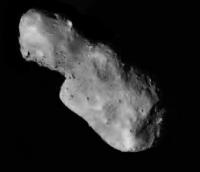
I'm trying to figure out what the scale of the image is, with the endgame, of course, being the addition of this body to my asteroids-visited-by-spacecraft montage. A major question for an elongated body is: are we seeing its maximum dimension, or is it foreshortened?
From this JPL page, the radar-derived dimensions of Toutatis: "The asteroid's maximum extents along the principal axes are (1.92, 2.29, 4.60) +/- 0.10 km. " Measuring on the photo, I get that the long axis here (which may not be the full length, if it's not broadside-on) is 792 pix The short axis here should be somewhere in between the 1.92 and 2.29 axes, and it's 312 pix That ratio is about 0.4, which is almost identical to 1.92/4.60 Which would mean that (assuming the JPL numbers are correct) we really are looking at it pretty close to broadside-on, with the plane of the sky being close to the plane of the minimum and maximum principal axes. Somebody please check my work!! -------------------- My website - My Patreon - @elakdawalla on Twitter - Please support unmannedspaceflight.com by donating here.
|
|
|
|
|
Dec 15 2012, 12:59 AM
Post
#66
|
|
 Member Group: Members Posts: 796 Joined: 27-February 08 From: Heart of Europe Member No.: 4057 |
My measurements are: long axis ~800 pix, short axis ~330 pix and ratio 0.4125.
-------------------- |
|
|
|
|
Dec 15 2012, 01:06 AM
Post
#67
|
|
|
Solar System Cartographer Group: Members Posts: 10146 Joined: 5-April 05 From: Canada Member No.: 227 |
I can confirm that this view shows the long dimension, probably no more than a little bit foreshortened. I think it's pretty much being viewed along its shortest axis, so we are seeing the long and intermediate axes.
Phil -------------------- ... because the Solar System ain't gonna map itself.
Also to be found posting similar content on https://mastodon.social/@PhilStooke NOTE: everything created by me which I post on UMSF is considered to be in the public domain (NOT CC, public domain) |
|
|
|
|
Dec 15 2012, 01:26 AM
Post
#68
|
||
|
Solar System Cartographer Group: Members Posts: 10146 Joined: 5-April 05 From: Canada Member No.: 227 |
Bringing out a bit more detail in the brighter areas:
(Thanks, Chinese space agency, for these great pictures) Phil -------------------- ... because the Solar System ain't gonna map itself.
Also to be found posting similar content on https://mastodon.social/@PhilStooke NOTE: everything created by me which I post on UMSF is considered to be in the public domain (NOT CC, public domain) |
|
|
|
|
|
|
Dec 15 2012, 01:46 AM
Post
#69
|
||
|
Member Group: Members Posts: 796 Joined: 27-February 08 From: Heart of Europe Member No.: 4057 |
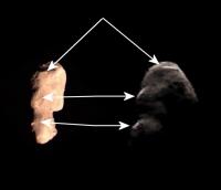
Attempted comparison with Goldstone radar imagery.
Attached thumbnail(s)
-------------------- |
|
|
|
|
|
|
Dec 15 2012, 02:37 AM
Post
#70
|
|
 Senior Member Group: Admin Posts: 4763 Joined: 15-March 05 From: Glendale, AZ Member No.: 197 |
Is there any doubt that we are looking at two distinctly separate objects in contact?
-------------------- If Occam had heard my theory, things would be very different now.
|
|
|
|
|
Dec 15 2012, 02:47 AM
Post
#71
|
|
|
Solar System Cartographer Group: Members Posts: 10146 Joined: 5-April 05 From: Canada Member No.: 227 |
If this is an approach sequence, there may be a departure sequence as well.
Phil -------------------- ... because the Solar System ain't gonna map itself.
Also to be found posting similar content on https://mastodon.social/@PhilStooke NOTE: everything created by me which I post on UMSF is considered to be in the public domain (NOT CC, public domain) |
|
|
|
|
Dec 15 2012, 02:58 AM
Post
#72
|
|
|
Administrator Group: Admin Posts: 5172 Joined: 4-August 05 From: Pasadena, CA, USA, Earth Member No.: 454 |
Beginning to look at the image and try some early (read: arm-waving) interpretation. Some things I notice: there are boulders that remind me of Itokawa. But they're sparse; it's substantially smoother than Itokawa. So I'd interpret that to mean it is mostly covered in a regolith. I also see circular depressions of a wide variety of sizes, the sort of thing one would tend to interpret as impact craters. Some have sharper edges than others. Of course, you have to be cautious; smaller ones especially might be collapse pits. I'm intrigued by the apparent roughness of the larger end. Again, though, I need to be careful; its apparent roughness could be due to lighting geometry. It's a pretty low-phase-angle image. Overall, it seems faceted. A slope map of this thing would be fascinating.
-------------------- My website - My Patreon - @elakdawalla on Twitter - Please support unmannedspaceflight.com by donating here.
|
|
|
|
|
Dec 15 2012, 03:01 AM
Post
#73
|
||
|
Junior Member Group: Members Posts: 86 Joined: 12-October 05 From: Beijing Member No.: 526 |
More info: 20 Kbps at 7 million km, 90% data has been received so far.
This is a television screenshot of a close-up image at 5 m/pixel, captured at 08:30:05, 47 km away. (Hope to have raw image soon)
Attached thumbnail(s)
|
|
|
|
|
|
|
Dec 15 2012, 03:07 AM
Post
#74
|
|
 Interplanetary Dumpster Diver Group: Admin Posts: 4404 Joined: 17-February 04 From: Powell, TN Member No.: 33 |
Thanks for posting that! I think you mean 5 m/pixel.
-------------------- |
|
|
|
|
Dec 15 2012, 04:30 AM
Post
#75
|
|
|
Solar System Cartographer Group: Members Posts: 10146 Joined: 5-April 05 From: Canada Member No.: 227 |
-------------------- ... because the Solar System ain't gonna map itself.
Also to be found posting similar content on https://mastodon.social/@PhilStooke NOTE: everything created by me which I post on UMSF is considered to be in the public domain (NOT CC, public domain) |
|
|
|
|

|
Lo-Fi Version | Time is now: 19th April 2024 - 07:24 PM |
|
RULES AND GUIDELINES Please read the Forum Rules and Guidelines before posting. IMAGE COPYRIGHT |
OPINIONS AND MODERATION Opinions expressed on UnmannedSpaceflight.com are those of the individual posters and do not necessarily reflect the opinions of UnmannedSpaceflight.com or The Planetary Society. The all-volunteer UnmannedSpaceflight.com moderation team is wholly independent of The Planetary Society. The Planetary Society has no influence over decisions made by the UnmannedSpaceflight.com moderators. |
SUPPORT THE FORUM Unmannedspaceflight.com is funded by the Planetary Society. Please consider supporting our work and many other projects by donating to the Society or becoming a member. |
|