Printable Version of Topic
Click here to view this topic in its original format
Unmanned Spaceflight.com _ Lunar Exploration _ Chandrayaan-II
Posted by: Pradeep Dec 21 2010, 05:47 PM
RussianSpaceWeb has reported that the possible landing sites for Chandrayaan-II called Luna-Resurs by the Russians have been selected. The selection is not final and seems to have been made (or covers only the Russian angle of the story) by Russian space organizations.
There is a detailed account of the selected landing sites for Chandrayaan-II here: http://www.russianspaceweb.com/luna_resurs_landing.html
Pradeep
Posted by: nprev Dec 21 2010, 06:55 PM
Thanks, Pradeep! 
South polar region, huh? Interesting! There's some pretty rough terrain down there, though the planners seem well aware of it based on the article.
Posted by: Phil Stooke Jun 24 2011, 09:53 AM
Much more info on site selection here. Chandrayaan 2 is called Luna-Resurs (Moon Resource) in Russia, and it's one of a pair of missions, the other called Luna-Glob. Luna-Resurs was supposed to fly in 2013 but may be delayed into 2014 by Indian issues, mainly with the launch vehicle, I believe. Luna-Glob will launch a year later. LR goes to the south, LG to the north. Now that they have found hydrogen in illuminated areas as well as permanent shadows the whole question of studying it is much easier, so the sites are no longer very close to the poles.
This link goes to an intro page from which you can link to numerous presentations, most of them in English. Thanks to our Russian colleagues for making them available.
Phil
http://www.iki.rssi.ru/eng/conf/2011-lg/index.html
Posted by: Phil Stooke Jan 4 2018, 07:36 AM
I am resurrecting this ancient thread because, after a long wait, Chandrayaan 2 will soon be launched to the Moon.
The links above give some information on very early thoughts about this mission, which was to be a joint India-Russia flight. The Russians called the mission Luna-Resurs (resources), and they would provide a lander and in some versions of it, a rover as well. India provided an orbiter and a mini-rover as well as a launch. Later the Russians pulled out and India took over all aspects of the mission.
The site selection work described above went through multiple phases in Russia. When India took over they did some of their own work on site selection. See this report from LPSC in 2015:
https://www.hou.usra.edu/meetings/lpsc2015/pdf/1351.pdf
Some work has been done since by two groups that I am aware of, but I am waiting for a paper release before I can say more. Don't pay too much attention to press reports which are almost always out of date.
The rover mission is only intended to survive one lunar day, and its activities will be recorded here.
Phil
Posted by: Phil Stooke Feb 1 2018, 05:00 AM
Some landing site news:
http://www.sciencemag.org/news/2018/01/india-plans-tricky-and-unprecedented-landing-near-moon-s-south-pole
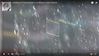
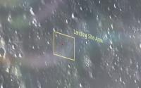
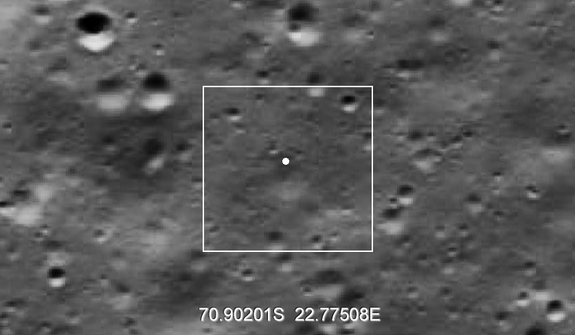
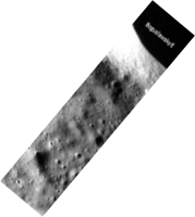
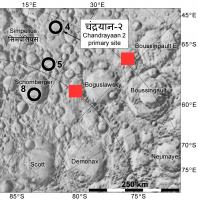
This article says that the site will be on a "plain between two craters, Manzinus C and Simpelius N, at a latitude of about 70° south", in other words here:
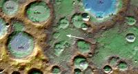
|
The coordinates are approximately 70.8 south, 22.9 east.
The article has a horrible representation of the zone of previous landings with red dots apparently purporting to be old landing sites, but they are just random. Really, how hard would it have been to do that right? However, we may have a site at last. I hope there will be something about it at LPSC - whose abstracts will be released on Friday!
Phil
Posted by: John Moore Feb 1 2018, 10:07 PM
Thanks, Phil...have added a http://the-moon.wikispaces.com/Chandrayaan-2 page for such.
John Moore
Posted by: Phil Stooke Feb 1 2018, 11:56 PM
I can confirm there will be new details at LPSC... plus a whole lot on Chinese sites.
Phil
Posted by: John Moore Feb 2 2018, 12:13 AM
Cheers. Phil...the LPSC abstracts are never short of wonderful disclosures - particularly, concerning research about the Moon. So much appreciation to YOU for the updates and links.
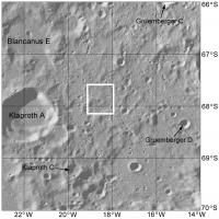
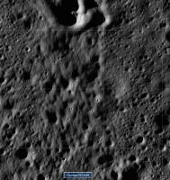
A https://www.hou.usra.edu/meetings/lpsc2018/pdf/1975.pdf (PDF file) - east of Klaproth A (68.2S, 21.84W), that may be another area for the upcoming mission - if announced in the https://www.hou.usra.edu/meetings/lpsc2018/
John Moore
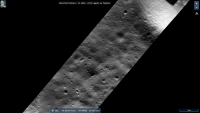
Posted by: Phil Stooke Feb 2 2018, 04:24 PM
Yes - here is the location of that site - in the white box.
Phil
|
Posted by: Sean Feb 2 2018, 06:30 PM
http://quickmap.lroc.asu.edu/?layers=NrBsFYBoAZIRnpEoAsjZwLpNKG%2BscB2fDbMADlPnNAE5rDgjZWakiE2mAmOuqt3J9%2BjTOKQ9QPRkmBSuBcgGZoPQUskVVYicDhwo3OQbRCkBkueCroisls5iLO63GX32%2B5cufe8bspWmt4M1urKMuEURFEhcChsDvIU9LoqPHEYcpGeWHqqymGkAHRQIKqJ6UiFZqXlNtDKRkoFTb7GFWrFrGUqTUkwfTVNntDDjZHU4%2BDiKtKyFaBjJTyzNaAd9fN1ves2ENN9bcoaezlNAdsjQUezBUS7iBVEW72G-TxP4x8ja0e-RpSAH7VQ8YLve4qIhXbIvFrJIJnLxBHooiiDJinPIqChZdFvdFPfLkRKYnKiaxgwlYtT4kkbCHPA6wlGgZG8GKY%2BZorEsPxBHE1WLVYAoL6LMU8QnjZSk-5JEpypDi1njOhzFXgGlyFDgemk8AIoZQkZwXkXaCs2nQYn9JoC6BOvz67laTZ%2BdSHaKoT2pa3CVIczXAcCGAjMsNoRRMMNM2NwYNIMO88j6lZENOZI6Z93x%2B0GkbQY0kzBAA&extent=-35.998326197833705%2C-70.70532958679142%2C18.47328720965808%2C-49.56957241261599&camera=589275.3966559898%2C-90829.97348161641%2C-1727956.447128716%2C5.469221050470949%2C-0.6318525454154313%2C6.283185307133074&proj=22
Posted by: John Moore Feb 2 2018, 10:19 PM
Phil, Seán...very nice, different perspectives.
Looking forward to the mission.
John Moore
Posted by: Phil Stooke Mar 24 2018, 02:15 PM
The Chandrayaan 2 launch is postponed until October. That may mean that it and Chang'E 4 will be driving around on the Moon at the same time, keeping any lunar cartographers out there pretty busy.
Phil
Posted by: Phil Stooke Aug 12 2018, 09:36 PM
https://www.hindustantimes.com/india-news/india-s-second-lunar-mission-to-land-on-moon-with-lander-rover-isro/story-vqoGvAyk6hHuUL4SDa17GJ.html
Launch will now be no earlier than 3 January 2019, and the lander has been named Vikram after V. A. Sarabhai, regarded as the initiator of the Indian space program. No word I am aware of concerning a name for the rover.
Phil
Posted by: Phil Stooke Sep 25 2018, 10:36 PM
https://timesofindia.indiatimes.com/india/chandrayaan-2-several-challenges-to-meet-jan-2019-deadline/articleshow/65945202.cms
description of changes to Chandrayaan 2, which leaves me concerned that more testing might be needed and could lead to further delays. I hope everything will be OK. I would not want to see a premature launch just to meet a schedule.
Phil
Posted by: Explorer1 Sep 25 2018, 10:47 PM
That's got to be a typo!
Based on the image, wouldn't a go landing attitude allow sunlight to reach the rover? Or it is a matter of not being able to guarantee the panels face the right way during landing?
Posted by: Thorsten Denk Apr 1 2019, 12:47 PM
Chandrayaan-2 launch now NET May.
https://www.asianage.com/science/010419/isro-to-launch-pslvc-46-followed-by-pslvc-47-chandrayaan-2-in-may-k-sivan.html
Thorsten
Posted by: Phil Stooke May 1 2019, 08:31 PM
Another month, another date: mid-July.
https://twitter.com/isro/status/1123612384336027650
And that tweet has a name for the rover, Pragyan, meaning Wisdom according to Wikipedia, or Knowledge according to New Delhi TV.
Phil
Posted by: John Moore Jul 22 2019, 11:47 AM
India's Chandrayaan 2 lunar mission to the Moon has successfully launched today, 22 July 2019 (at 0913 GMT) from its space centre in Sriharikota, near the Bay of Bengal.
Already having separated from its launcher's second stage and now in Earth orbit, Chandrayaan 2 is expected to touchdown on the lunar South Pole some time in early September 2019.
The mission includes both a lander and rover (also with an orbiter overhead); where all three include various research instruments (13 of Indian, 1 of NASA) used in areas, for example:
looking for water and minerals signatures, and the study of moonquakes and possible future landing sites...amongst other activities. The orbiter has eight instruments, the lander with
four (including the NASA instrument), while the rover has the remaining two.
On touchdown, the solar-powered rover will off-load from the lander after some four hours, where it will then mainly rove around the surface during lunar day-long (14 earth days) stints.
Posted by: Thorsten Denk Jul 22 2019, 12:27 PM
Finally they're on their way.
Lunar Landing is expected Sept 7 at 2:50 AM Indian Standard Time or Sept 6 at 21:20 UT.
Friday evening for Europe, afternoon for America.

I wonder why all the time they say "on the South Pole".
The landing Site is at 70°S, this is still 600km from the pole.
It's the nearest lunar soft landing to a pole ever, but not yet "on" the pole...
Thorsten
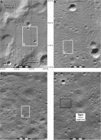
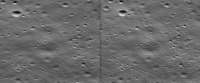
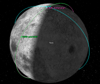
Posted by: Phil Stooke Jul 22 2019, 06:10 PM
Here is a set of 'finder' maps for the primary landing site and the alternative site.
Phil
|
Posted by: John Moore Jul 23 2019, 12:44 AM
Just querying: while during the long, lunar day (14 earth days) stints that the Chandrayaan 2 rover (Pragyan) is expected to undergo near/below the 70.0s degree South Pole environment, will
the different, southerly periodic lighting conditions, let alone the temperatures changes, affect the amount of days that the rover can rove (I'm thinking that the various powering down/up
periods might be shorter: simply due to less illumination time on the solar panels at such latitudes, but then, do the lower temperature differences, lighting conditions counteract such - allow longer exploration times).
John
Posted by: MahFL Jul 23 2019, 01:25 AM
Gratz to ISRO on a successful launch.
Posted by: Explorer1 Jul 23 2019, 01:26 AM
Perhaps the 'noon naps' that Yutu has been commanded to do to avoid overheating might not be necessary, if the sun never gets too high above the horizon?
I'm certainly looking forward to surface images, both in terms of long shadows and Earth near the horizon....
Posted by: JRehling Jul 23 2019, 02:53 AM
The amount of solar radiation that the panels receive will depend upon the angle between the panels and the Sun. The angle of the ground to the Sun is irrelevant. The imagery I see online indicates that the solar panels are not horizontal, so I presume that they will be oriented for better energy production.
Posted by: Thorsten Denk Jul 23 2019, 08:22 AM
Hi all!
Some thoughts:
"Noon naps" (here in Spain: siesta) are probably not necesary, because the sun never rises more than 20deg above the horizon. This keeps the surface temperature rather low.
Thermodynamic equilibrium:
- Max. solar irradiation on horizontal surface: 1367W/m² x cos(70°) = 470W/m²
- Thermal reradiation: 470 = 5.67e-8 x T^4
=> Noon-Temperature T = 301K = 28°C (like here last night  )
)
This is approximately, no reflection of sunlight or emittance of IR <1 was included.
But in any case, not as hot as on other places.
At the time of landing, the terminator is at 0deg longitude. The landing site is at 23°E, this means that at this site, the sun is already 1.5 Earth-days up. This has to be taken into account when somebody speaks about "14-Earth days operation time". It will be not more than 12.5 Earth days. If they achieve night survival, then it will be more of course. (This does not take into account possible "seasonal effects". As the Moon's axis is tilt only 1.5° vs the ecliptic, this is normally negligible, but not when coming close to a pole. 70°S is not yet close enough to be important, but I wouldn't be surprised if they could win (or loose) another half a Earth-day or so. And, of course!, terrain also matters! If there's a small hill in the west, the sunset might be significantly earlier.)
If somebody wants to do detailed calculations, this great page helps: https://trek.nasa.gov/moon/index.html
The solar panels of the lander and the rover are mostly vertical. As far as I can see on the photos, neither panel is steerable.
The lander has one side (I suppose this will face south) with the rover and without solar panels, another two sides (I suppose facing east and west) with solar panels, and one side (I suppose facing north) that's never visible in the photos, so I don't know what's there. Hopefully another solar panel. If not, they will have a hard time around local noon.
The lander has one solar panel that can be flipped to vertical, but doesn't seem to be steerable! This means that the lander should always move or at least park in a sun facing direction! Remember, over the lunar day, the sun will move in the sky from east (at the horizon) to north (elevation <20°) to west (again at the horizon).
I wonder how they will manage the landing on a safe spot. The sun is very low during landing, and the shadows will be very long. A system like the one used by Cháng'é-3 and 4 (imaging, terrain recognition) will probably have a hard time to work.
Shadows, yes, it will be interesting to see how they will hamper (or not?) the navigation of the rover. 
Somebody knows what capabilities they have to detect water?
I don't expect it directly on the surface, but not too many cm below, there might be traces.
Now let's cross fingers that they are successful with the flight and the landing. This place will give a first small hint about how the conditions on the real pole might be.
Regards
Thorsten
Posted by: John Moore Jul 23 2019, 08:45 AM
While fully admitting to not understanding the temperature/power complexities of sunlight falling on the lander and rover solar panels at such extreme latitudes, your description, Thorsten, is wonderful. Thanks
John
Posted by: elakdawalla Jul 25 2019, 05:37 PM
Note that the lander and rover are not expected to survive the lunar night. Their mission will last one lunar daytime, 14 Earth days, according to mission materials. I'm a little confused by this number because I can't imagine a successful landing during the very twilit high-southern-latitude dawn; it seems to me they'll have to land under relatively high sun conditions. But that's speculation on my part.
Posted by: Phil Stooke Jul 25 2019, 06:29 PM
The statement is ambiguously worded, but I think they are saying 'the lander and rover will last for one lunar day' and 'one lunar day is 14 Earth days'. I saw it said somewhere that the landing is about 36 hours after sunrise, so you are quite right that the actual surface missions must be shorter. We can probably expect a maximum of 12 days operation. We had better hope a noon siesta is not required!
Phil
Posted by: elakdawalla Jul 25 2019, 06:31 PM
Thanks, I had missed that detail. I'm still impressed by a landing 36 hours after sunrise at that latitude!
Posted by: nogal Aug 7 2019, 06:27 PM
The Chadrayaan-2 mission seems to be proceeding according to plan, the probe having successfully completed all the Earth orbit raising manoeuvres on August 6. The next orbital change is the trans-lunar injection, scheduled for August 14.
Here is a comparison table for the attained and planed orbits.

|
The information is taken from the https://www.isro.gov.in/chandrayaan2-latest-updates and the https://www.isro.gov.in/update/24-jul-2019/chandrayaan-%E2%80%93-2-update-optimised-mission-plan-of-chandrayaan-%E2%80%93-2-spacecraft
Fernando
Posted by: Roby72 Aug 13 2019, 11:26 PM
Success for Lunar Tranfer Trajectory:
https://www.isro.gov.in/update/14-aug-2019/chandrayaan-2-successfully-enters-lunar-transfer-trajectory
Posted by: nogal Aug 14 2019, 12:07 AM
Here is an updated table with the latest information.
Fernando

|
Posted by: Phil Stooke Aug 20 2019, 05:23 AM
https://www.isro.gov.in/update/20-aug-2019/chandrayaan-2-update-lunar-orbit-insertion
Lunar orbit!
Phil
Posted by: Phil Stooke Aug 22 2019, 10:30 PM
https://www.isro.gov.in/sites/default/files/presentation_moon_photo1.png
First image of the Moon, with the Orientale basin at the top and north at upper left.
Phil
Posted by: Steve G Aug 23 2019, 09:16 PM
First image of the Moon, with the Orientale basin at the top and north at upper left.
Phil
That's an amazing picture. Our moon is so wonderfully diverse and interesting. I can never get bored gazing at its majesty.
Posted by: John Moore Sep 1 2019, 04:05 PM
Well, looks like all went well on the fifth manoeuvre, 1 Sept, 2019, and also an update, 2 Sept, 2019, on the successful separation of the Vikram Lander (with the Pragyan rover onboard) from the orbiter.
Below image (Credit: ISRO): a tentative plan over the next few days up to the 7 Sept, 2019...when India's engineers' nerves will undoubtedly be fraying towards a successful landing.
John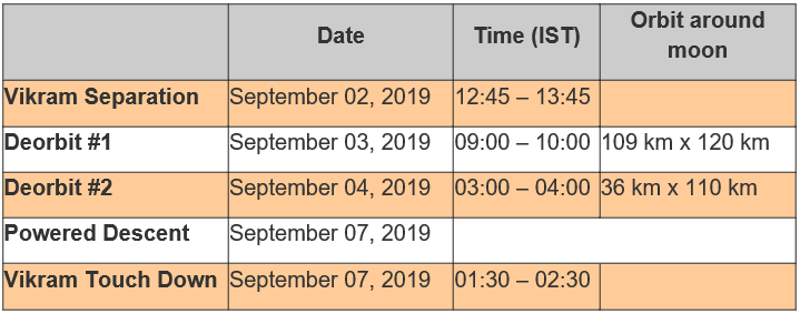
Posted by: charborob Sep 4 2019, 01:41 AM
The Vikram lander has reached its final orbit (35 x 101 km) before its descent to the Lunar surface (scheduled for Sept. 7).
https://www.isro.gov.in/chandrayaan2-latest-updates
Posted by: Phil Stooke Sep 4 2019, 08:49 PM
The sun is about to rise on the landing site, and the high resolution camera on the orbiter is supposed to image the site for final site planning. The resolution will be about 30 cm/pixel, better than a standard 50 cm/pixel LROC NAC image and almost as good as the low altitude images (25 cm/pixel) NAC obtained over several of the Apollo sites. It will be great to see the site before and after landing with this camera, and really nice to see images of other sites with the same camera if they are taken. For instance, LRO images of the Chang'e 4 site are about 1 m/pixel, so this camera might give us 3x better resolution. I hope the camera team plan images of other sites at that resolution.
Phil
Posted by: John Moore Sep 5 2019, 07:00 PM
Below, an approximate render of the lighting conditions of the 6 Sept, 2019 (round 6.00 pm UTC )
for successful landing of Vikram. Simpelius N and Manzinus C, lie roughly at the centre of the ellipse.
John
Posted by: SpaceListener Sep 6 2019, 08:11 PM
At this moment, Vikram will start the descending trajectory shortly.
Posted by: Seryddwr Sep 6 2019, 08:25 PM
Live feeds not looking good; it seems the lander deviated from its trajectory in the final moments of the descent a few minutes ago. No downlink
Posted by: SpaceListener Sep 6 2019, 08:28 PM
A steeper inclination than the planned trajectory indicates some failure propulsion along without a downlink signal. I am afraid that Vikram has not landed as planned, softly. The last info from the panel was that its altitude was 1 km above the surface at 59 m/s (an acceptable landing speed must not be greater than 15 m/s). The people from the operation center are uneasy trying to figure out this incident.
Posted by: Seryddwr Sep 6 2019, 08:39 PM
Rough luck, that. Space is hard! Hope ISRO can swiftly recover from this failure.
Posted by: Seryddwr Sep 6 2019, 08:48 PM
India Today's live feed reporting that all was well up to an altitude of 2.1 kilometres. Communication was lost after that. Sounds like the issue was to do with the 'fine braking' phase - a misfiring or failed engine, perhaps?
Posted by: nprev Sep 6 2019, 09:02 PM
Aaaaaaah....damn. 
My most sincere sympathies to the Chandrayaan II team. There is absolutely nothing easy nor routine about landing on another world. This was a truly brilliant & ambitious effort, and though lessons learned are always painful they are always invaluable as the only real way forward to new futures.
Posted by: SpaceListener Sep 6 2019, 09:05 PM
What problem coincidence of Vikram with the ones of Israeli Moon lander Beresheet.
Posted by: kenny Sep 6 2019, 09:11 PM
Many congratulations to the Chandrayaan team for an excellent first attempt -- surely not the last from India.
Meanwhile the orbiter continues its scientific mission...
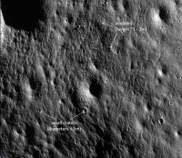
Posted by: Phil Stooke Sep 6 2019, 09:46 PM
Very sad outcome but a great effort, and a lot will be learned from it. Meanwhile, as already said, a good orbiter mission to come. I look forward to seeing the site from orbit, but meanwhile here is an updated landing sites map.
Phil

|
Posted by: Steve G Sep 7 2019, 04:31 AM
The last two failed landing attempts really puts into context the genius of the Surveyor and Luna landing teams half a century ago using computer rooms and slide rulers. A real shame and just illustrates how unforgiving space can be.
Posted by: Phil Stooke Sep 7 2019, 06:17 AM
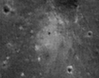
Well said, Steve.
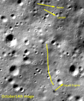
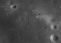
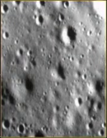
The live coverage included glimpses of this image:
|
It shows a specific landing area within the target ellipse. It should be easy to find in LRO images but so far I'm not able to identify it. The early morning illumination suggests to me it may be from the orbiter. It doesn't obviously resemble any LRO image I have seen yet. Scale is not clear, but another report in the Times of India said two specific sites 500 m by 500 m and 1.6 km apart had been picked in the landing ellipse.
Phil
Posted by: marsbug Sep 8 2019, 10:27 AM
If this is accurate... https://mobile.twitter.com/ANI/status/1170610654232731648
... then the lander may be more-or-less intact, depending on the image resolution. A bad landing, as opposed to a crash, perhaps. That might be of some comfort to the ISRO team ifso.
Posted by: Thorsten Denk Sep 8 2019, 10:36 AM
https://www.indiatoday.in/science/story/isro-finds-lander-vikram-exact-location-1596857-2019-09-08
Thorsten
Posted by: marsbug Sep 9 2019, 03:54 PM
The word from The Times of India is that Vikram is on the Lunar soil in one piece, but tilted on its side and possibly (probably imho) damaged after a hard landing. Even if it's functional there's a good chance the angle it's at will prevent communication, but the ISRO team will keep trying for the rest of the lunar day. Still, it looks like this was a hard but controlled landing, not a crash, and I think it's safe to say that Vikram fought right to the end. The ISRO team can be proud of their work, and the design is clearly up to the job - once whatever bug caused the hard landing is located and ironed out
https://m.timesofindia.com/india/isro-not-losing-hope-continues-to-make-all-out-efforts-to-restore-link-with-lander-vikram/articleshow/71045854.cms
Edit:: India Today's report is that the lander is not confirmed as 'intact', although I wonder if some ambiguity of translation isn't creeping in here: "In one piece" could mean one pile of bits all in one spot, or one very oblate piece. It'd be tempting to translate that as 'intact' but optimistic... Still, my statements on the ISRO team stands, even if it turn s out to be one big metal pancake.
https://www.indiatoday.in/science/story/chandrayaan-2-lander-vikram-intact-moon-isro-says-not-confirmed-1597265-2019-09-09
Posted by: Steve G Sep 9 2019, 08:35 PM
It might have had a similar fate as Luna 23 in 1974 which had a hard landing and tipped over. Intact, but loss of mission.
Posted by: Phil Stooke Sep 11 2019, 07:43 PM
Yes... we could be in for a long period of argument as to whether it should count as a landing or an impact.
Meanwhile, this tweet is interesting:
---------------------------------
Ryan Watkins @Ryan_N_Watkins
official word is that @LRO_NASA will take an image of the Vikram landing site on September 17th. The incidence angle is pretty high, so it may be hard to see (could be in shadow).
#VikramLander #Chandrayaan2 @isro
---------------------------------
(Ryan is a researcher at the Planetary Science Institute in Tucson)
LRO is orbiting close to the terminator at the moment. As it crosses the landing site each month over the next few months the Sun will be higher and the view better.
Phil
Posted by: marsophile Sep 11 2019, 07:56 PM
According to Wikipedia, the Chandrayaan II orbiter camera has a spatial resolution of 0.3 m from 100 km polar orbit, while the LRO camera is said to have a maximum resolution of 50 cm/pixel. If these figures are correct, is there any reason to hope the LRO images will be any better than the ones from the Chandrayaan II orbiter?
Posted by: marsbug Sep 11 2019, 08:48 PM
There is the possibility that we may get to see the LRO images before we do the Chandrayaan 2 ones! ISRO, love you, but I've been spoiled by the relative hosepipe of data and images NASA prefers, as opposed to the more cautious approach.
Posted by: Phil Stooke Sep 12 2019, 01:12 AM
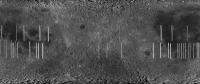
The 50 cm pixel resolution for LRO's Narrow Angle Camera is based on its altitude, nominally 50 km for its main mission period. They have dropped to 25 km for high resolution imaging of Apollo sites (25 cm per pixel), but now they are in a low-maintenance orbit to extend operational life, and they are higher up: approx. 50 km at the south pole, 200 km at the north pole. Most images of the Chandrayaan 2 site now available are about 100 cm/pixel.
Chandrayaan 2's high resolution camera has 30 cm/pixel resolution from 100 km altitude. I would expect that C2 images could be 3 times better than any LRO images we are likely to see.
Phil
Posted by: John Moore Sep 12 2019, 02:24 PM
Below, an overhead, animated attempt of the impact/hard-landing site (approximately at centre of Manzinus D), if indeed that is the actual site: showing the lighting/shadow conditions from 17 Sept., 12:00 noon UTC to 18 Sept., 12:00 noon UTC (note, libration effects have been removed simply for visualization).
John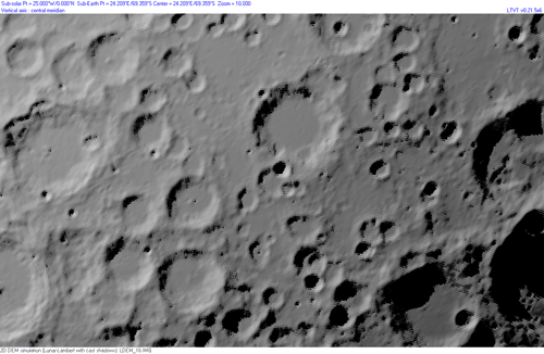
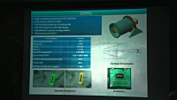
Posted by: mcaplinger Sep 12 2019, 03:18 PM
I haven't been able to find very much technical information about this camera beyond this phone image of an old viewgraph about it which I've enhanced a little. I'll be very curious to see how well this performs; the high resolution coupled with a large number of TDI stages (oddly high, actually, I've no idea why they need so many) presents a lot of challenges. LROC NAC was a much more conservative design in most respects.
|
Posted by: kenny Sep 12 2019, 08:03 PM
https://gulfnews.com/world/asia/india/chandrayaan-2-isro-racing-against-time-to-salvage-lander-rover-part-of-mission-1.66335279?fbclid=IwAR2Toe68CMZw7tvRKsF1Q2uBjUbs8T9EgdnPtvFeDPu9Qnxd8t7vY2-79Q0
A senior Isro official associated with the mission said: The images from the orbiter camera showed that Vikram is in single piece lying on the lunar surface; not broken into pieces. It is in a tilted position. Its not in its four legs, as usual.
This official added on condition of anonymity: Its not upside down. Its lying on its side.
Isro officially did not comment on the condition of the lander.
Chandrayaan-2 comprises an orbiter, lander (Vikram) and rover (Pragyan).
The mission life of the lander and rover is one lunar day, which is equal to 14 earth days.
Posted by: kenny Sep 12 2019, 08:06 PM
Additional location information from the above ref. ...
"An Isro official said Vikram hit the lunar surface at a place about 500 metres away from where it was originally planned to touchdown. "
Posted by: Roby72 Sep 12 2019, 09:18 PM
|
|
As I see on Dsn Now page the data rate of Chandrayaan II orbiter is now quite low in a range of only 1 kbit/sec.
LRO has more than 100 times more typically.
We will see if they have higher data rates to send big images - anyone knows about this more ?
Posted by: mcaplinger Sep 12 2019, 11:08 PM
ISRO has their own network, I don't even know if DSN will be used operationally. https://directory.eoportal.org/web/eoportal/satellite-missions/c-missions/chandrayaan-2 I couldn't find anything about specific data rates.
On Ka-band, LRO can send data at 100-300 Mbps.
Posted by: Ohsin Sep 18 2019, 05:57 AM
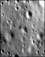
The live coverage included glimpses of this image:
|
|
It shows a specific landing area within the target ellipse. It should be easy to find in LRO images but so far I'm not able to identify it. The early morning illumination suggests to me it may be from the orbiter. It doesn't obviously resemble any LRO image I have seen yet. Scale is not clear, but another report in the Times of India said two specific sites 500 m by 500 m and 1.6 km apart had been picked in the landing ellipse.
Phil
I was able to match the perspective corrected OHRC image shown on screens of Mission Operations Complex with LROC images of the intended primary landing site, sun angle was making the scene look slightly different.
https://www.youtube.com/watch?v=KJJov3tXfOU
OHRC image labelled as taken on 6 September 2019 on 2030 IST (Indian Std. Time) can be seen in broadcast at 14 min. mark onwards
https://www.youtube.com/watch?v=7iqNTeZAq-c&t=831
Marked "Landing Site Area" in yellow box appears to be roughly 50×65 meters in dimension. Placed a 2×2 m 'lander sized' red dot for comparison within it in attached image. Mapped the 15×8 km landing ellipse along intended landing box and primary and alternate landing sites given in LPSC 2018 paper and during broadcast on https://quickmap.lroc.asu.edu/?extent=22.7466873,-70.910248,22.8208723,-70.8910448&proj=17&features=22.78110000,-70.90267000%7C-18.46947000,-67.87406000%7C22.67614545,-70.66505312,22.59602674,-70.68567374,22.47404942,-70.73985102,22.41186851,-70.81152910,22.37729450,-70.90503611,22.39786447,-70.96649012,22.44897667,-71.03179022,22.49475155,-71.06875459,22.55335003,-71.10391166,22.66112520,-71.13706952,22.78284794,-71.15270805,22.90395627,-71.13943872,23.00991370,-71.10391180,23.07951916,-71.07113016,23.11649306,-71.03492583,23.16767306,-70.97185758,23.19380184,-70.90378735,23.16174278,-70.82041445,23.08489490,-70.74625635,22.96500141,-70.68691309,22.88051038,-70.66585094,22.77779645,-70.65721583,22.67614545,-70.66505312%7C22.78110000,-70.89992000%7C-18.46947000,-68.74915000%7C22.78085353,-70.89972614,22.78733747,-70.90007004,22.78681751,-70.90184907,22.78037202,-70.90153733,22.78085353,-70.89972614&selected=5&layers=NrBsFYBoAZIRnpEoAsjZwLraeOUNEQBmOOY9ebbIA
In broadcast the launch commentator mentioned that the command for descent was sent 84 minutes prior to it and chosen coords were (-70.899920, 22.78110) and alternate site coords at (-68.749153, -18.46947)
|
|
That slide on OHRC is snapshot I took during a livestreamed presentation of User Interaction Meet of 2016 held by ISRO's National Remote Sensing Centre. http://livestream.nrsc.gov.in/CartoSession-4.html is no longer available and was mainly about Cartosat series of Earth Observation satellites.
Meanwhile we might have to wait for LROC imagery a bit longer.
https://aviationweek.com/awinspace/nasa-s-lro-fails-spot-chandrayaan-2-lander
|
|
Posted by: John Moore Sep 18 2019, 09:01 PM
So, the site is roughly between Manzinus C and Simpelius N.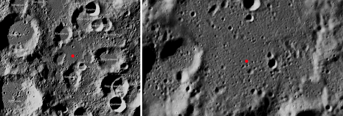
John
Posted by: Phil Stooke Sep 20 2019, 07:34 PM
Here's a locator map for the target area.
Phil
|
Posted by: Ohsin Sep 27 2019, 02:32 AM
Images from most recent LRO pass have been released.
https://www.lroc.asu.edu/posts/1128
Posted by: mcaplinger Sep 28 2019, 02:35 PM
This thread is getting out of control with Chandrayaan-1 MIP discussion. IMHO most of the recent posts should be moved to http://www.unmannedspaceflight.com/index.php?showtopic=2686
Posted by: Phil Stooke Sep 29 2019, 04:41 PM
Mike is right. It's my fault, as I looked at the other thread and it had not been updated for 7 years, but I only expected 2 or 3 posts on the subject. Now I think there is a lot more to say on the subject and this is the wrong place for it.
A new thread might be good, but moving to the old thread would be fine too.
Phil
Posted by: nprev Sep 29 2019, 09:47 PM
C-1 MIP impact site posts http://www.unmannedspaceflight.com/index.php?showtopic=2686 per request. Good call.
Posted by: John Moore Sep 30 2019, 01:33 PM
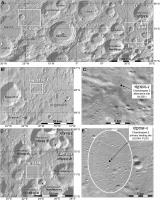
As this 'U-type' feature showed up (during a blink-comparison technique) not far from the possible/proposed Vikram site (rectangle), I'll throw it out there (some small craters visible in the hig-rez below, may be responsible for the effect).
But, these are shadowed times, and as everyone knows, such can change the look of a smooth, slightly-undulated terrain in to one unrecognisable, so take it with a pinch of salt. The second image is an extreme close-up of the feature mentioned.
John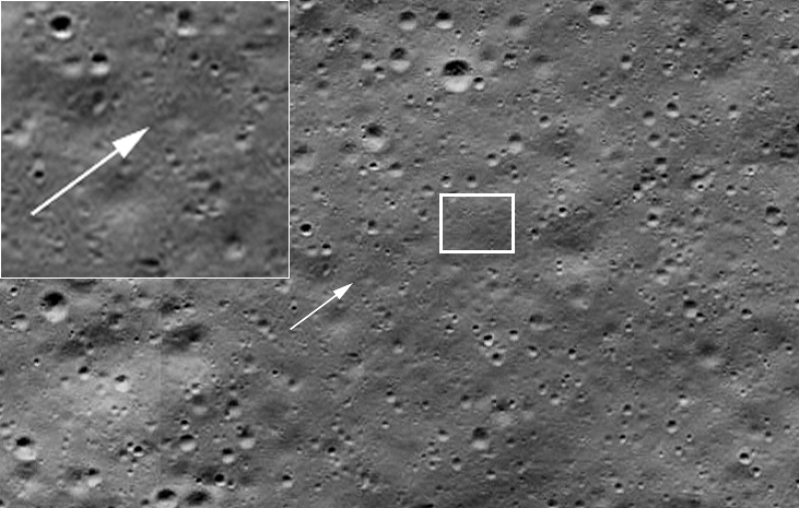
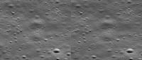
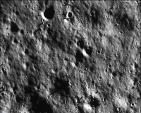
Posted by: Steve G Oct 1 2019, 02:24 AM
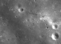
In the LROC pictures I browsed through, found some interesting braided terrain in the Chandrayaan 2 lander search area.
|
Posted by: Phil Stooke Oct 1 2019, 03:33 PM
That is formed by a spray of ejecta falling on the surface, lots of small bits together rather than one big chunk forming a secondary crater. It is a common feature, but the low relief hardly shows up in higher sun angle images.
Phil
Posted by: Ohsin Oct 1 2019, 08:07 PM
http://www.unmannedspaceflight.com/index.php?showtopic=6862&view=findpost&p=245700
Made a cross-view of planned primary landing site based on above.
|
Posted by: atomoid Oct 1 2019, 10:15 PM
Thanks, i always enjoy these. I rotated each 180 to reduce headache. If you dont already use http://stereo.jpn.org/eng/stphmkr/index.html youll find it very useful
|
Posted by: Ohsin Oct 4 2019, 03:10 PM
Few images from OHRC at last but not of impact site unfortunately.
https://www.isro.gov.in/update/04-oct-2019/chandrayaan2-images-orbiter-high-resolution-camera
Posted by: mcaplinger Oct 6 2019, 05:38 PM
It would be an interesting exercise to find LROC coverage of this area and do a quality comparison. I tried looking but but wasn't able to find overlapping images in the few minutes I had to spend.
Posted by: Ohsin Oct 7 2019, 06:08 PM
My guess is this is our broad area of interest but I am yet to find exact spots for good one to one comparison.
https://ode.rsl.wustl.edu/moon/indexproductpage.aspx?product_id=M1251626568RC
https://ode.rsl.wustl.edu/moon/indexproductpage.aspx?product_id=M1282199397RC
https://ode.rsl.wustl.edu/moon/indexproductpage.aspx?product_id=M1282199397LC
https://quickmap.lroc.asu.edu/query?extent=53.00086,-75.17099,55.5959342,-74.3776977&proj=17&features=54.08700000,-74.26300000|54.57179933,-74.91099022,54.51626307,-74.89763852,54.57968005,-74.87829832,54.63850340,-74.89226727,54.57179933,-74.91099022&selected=1&query=95&layers=NrCsEZQGgBlrxRAZnOZD7gLq+0A to relevant area.
First attached image is of OHRC overview rotated 40° to match LROC mosaic.
|
|
|
|
|
|
|
|
|
|
Posted by: Phil Stooke Oct 22 2019, 07:09 PM
Thanks for finding the images.
Here is some news about the SAR on Chandrayaan 2:
https://www.isro.gov.in/update/22-oct-2019/initial-imaging-and-observations-chandrayaan-2-dual-frequency-synthetic-aperture
Phil
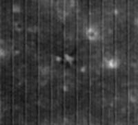
Posted by: Phil Stooke Oct 23 2019, 10:33 PM
Latest on the LRO search for Vikram is that the new imaging this month also failed to spot the lander.
https://www.indiatoday.in/science/story/chandrayaan-2-vikram-lander-not-found-new-nasa-photos-moon-landing-site-1612124-2019-10-23
Shadows are invoked again, but my feeling is that the lander crashed further from the target than expected and is not in the imaged area, which appears to be looking at the landing target. I have not yet seen a detailed analysis of the expected impact location, but if Vikram was tumbling and thrusting after loss of contact, as seems to be suggested in some reports, it could be off top the side of the groundtrack a bit more than expected.
Phil
Posted by: Ohsin Oct 25 2019, 03:32 AM
It appears there is no coordination on search for impact location.
https://www.space.com/india-moon-lander-not-found-by-nasa.html
May be they are being coy on location information to get some science done first and fast.
http://www.newindianexpress.com/nation/2019/sep/18/chandrayaan-2-hard-landing-of-vikram-to-help-orbiter-look-for-water-on-moon-says-isro-2035311.html
Posted by: SpaceListener Oct 25 2019, 03:34 PM
As it is very hard to find the lander Vikram after one month, I am supposing that Vikram didn't impact so hard and its impact footprint will not show any burned pieces due to the combustion which facilities the probability to spot it due to the change of the color of the surface. The other possibility is that the lander is laid on the side and reduce its shadow.
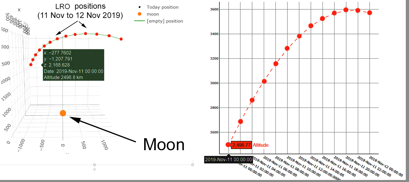
Posted by: John Moore Nov 11 2019, 07:42 PM
Top: An aerial view of the lighting conditions for when LRO passed over the 'Vikram' site today, 11 Nov, 2019 at 1:21:04 UTC (note, these are approximate calculations, so apologies, if incorrect).
Bottom: An 24-hour (11/11/2019 to 11/12/2019) graphic view of LRO's increasing altitude (note, sometimes American versus European date descriptions are published differently, however, in this
case, the format is Month/Day/Year).
LRO's orbital track is moving westwards, the site is becoming evermore brighter (terminator movement), as the Sun steadily climbs overhead.
John Moore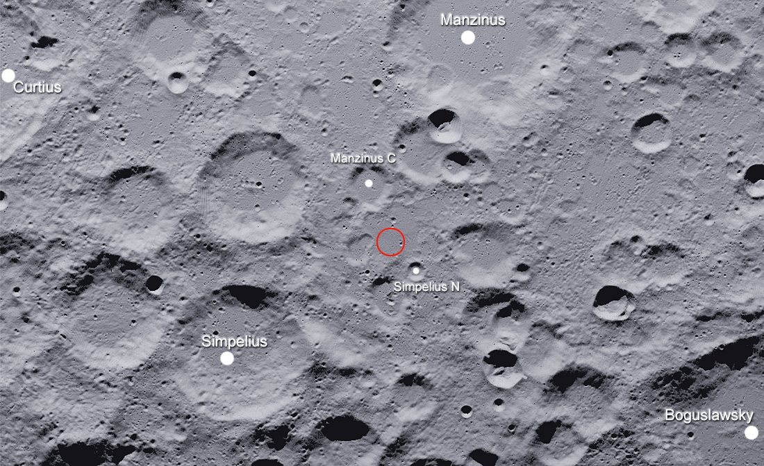
Posted by: Ohsin Nov 13 2019, 11:52 PM
Updates related to CHACE-2 and TMC-2 on orbiter
https://www.isro.gov.in/update/31-oct-2019/detection-of-argon-40-lunar-exosphere
https://www.isro.gov.in/update/13-nov-2019/topographic-mapping-using-tmc-2-of-chandrayaan-2-initial-results
Apparently they are working out another attempt at landing before November 2020 with a lander/rover configuration and a detachable propulsion module.
https://timesofindia.indiatimes.com/india/chandrayaan-3-second-bid-to-land-on-moon-by-november-2020/articleshow/72047390.cms
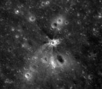
Posted by: Ohsin Dec 2 2019, 08:23 PM
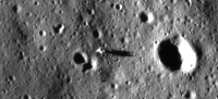
They found it!
http://lroc.sese.asu.edu/posts/1131
Here it is on https://quickmap.lroc.asu.edu/query?extent=22.6172488,-70.9288302,22.9138315,-70.8520346&proj=17&features=22.78110000,-70.90267000%7C22.67614545,-70.66505312,22.59602674,-70.68567374,22.47404942,-70.73985102,22.41186851,-70.81152910,22.37729450,-70.90503611,22.39786447,-70.96649012,22.44897667,-71.03179022,22.49475155,-71.06875459,22.55335003,-71.10391166,22.66112520,-71.13706952,22.78284794,-71.15270805,22.90395627,-71.13943872,23.00991370,-71.10391180,23.07951916,-71.07113016,23.11649306,-71.03492583,23.16767306,-70.97185758,23.19380184,-70.90378735,23.16174278,-70.82041445,23.08489490,-70.74625635,22.96500141,-70.68691309,22.88051038,-70.66585094,22.77779645,-70.65721583,22.67614545,-70.66505312%7C22.78110000,-70.89992000%7C22.78085353,-70.89972614,22.78733747,-70.90007004,22.78681751,-70.90184907,22.78037202,-70.90153733,22.78085353,-70.89972614%7C22.78400000,-70.88100000&selected=4&layers=NrBsFYBoAZIRnpEoAsjZwLraeOUNEQBmOOY9ebbIA
Edit: The person credited in press release for helpful inputs is https://twitter.com/Ramanean
Posted by: marsophile Dec 4 2019, 03:33 AM
https://timesofindia.indiatimes.com/india/isro-plays-down-chennai-techies-spotting-of-vikram-lander/articleshow/72357057.cms
Reaction in India to the finding.
Posted by: marsbug Dec 4 2019, 11:30 AM
I feel like I ought to say: In a time when scientific research and the value of scientific thinking are under attack ISRO have behaved very irresponsibly with how they've shared information, giving the impression that they've put the truth as a lower priority than saving face. I'll not comment on the matter again here, and it is definitely my opinion only.
Posted by: Huguet Dec 4 2019, 04:21 PM
Recently we had 4 attempts, CNSA chang e'3 on 14/dec/13 succesfull, CNSA chang e'4 on 3/jan/19, SpaceIL beresheet on 11/apr/19, Chandrayaan on 06/set/2019.
The last two atempts were unsuccesfull on the same stage, at the landing aproach, they are extremelly important to the learn process and improvement of the next ones. But its information need to be shared, otherwise it will have much less relevance.
Nasa LROC images will contribute a lot to fill this gap.
Posted by: marsbug Dec 12 2019, 02:31 PM
WRT the crash, the LROC images show some debris scattered back along the ground track at quite a distance. Given the (very likely) angle and velocity of the impact this doesn't seem very strange to me - my layman's knowledge and reading is that hypervelocity impacts will produce a more or less even debris field around the impact unless the angle of impact is very, very low. But on other forums this seems to be a topic under discussion - how anything could be scattered the opposite way to the direction of the ground track. Given the concentration of expertise here I was wondering if anyone here found it unusual?
Posted by: Ohsin Dec 13 2019, 01:12 PM
There is stored energy in form of propellant and pressurant on lander which could eject debris in random direction. Could it be that anomaly occurring ~2 km above surface was severe enough to generate some debris before impact? For example lander during reconfiguration was attached with an extra solar panel that jutted out towards front.
Posted by: marsbug Dec 15 2019, 12:15 AM
Thanks. That seems possible, but I'm not sure I understand why that's needed as an explanation - from the publicly available data I've seen the impact velocity was at least 50m/sec, the impact angle was at least 45 degrees... none of that seems inconsistent with the idea that debris could be scattered back along the ground track to me, I'm just wondering if I'm missing something wrt why it's even coming up as a topic of discussion in the wider internet.
Posted by: Ohsin Jan 24 2020, 05:46 AM
Few official papers detailing CY-2 payloads.
Current Science, Volume 118 - Issue 1 (10 January 2020)
https://www.currentscience.ac.in/php/toc.php?vol=118&issue=01
Solar X-ray Monitor onboard Chandrayaan-2 Orbiter
https://www.currentscience.ac.in/Volumes/118/01/0045.pdf
Alpha Particle X-ray Spectrometer onboard Chandrayaan-2 Rover
https://www.currentscience.ac.in/Volumes/118/01/0053.pdf
and
Current Science, Volume 118 - Issue 2 (25 January 2020)
https://www.currentscience.ac.in/php/toc.php?vol=118&issue=02
CHandras Atmospheric Composition Explorer-2 onboard Chandrayaan-2 to study the lunar neutral exosphere
https://www.currentscience.ac.in/Volumes/118/02/0202.pdf
Dual Frequency Radio Science experiment onboard Chandrayaan-2: a radio occultation technique to study temporal and spatial variations in the surface-bound ionosphere of the Moon
https://www.currentscience.ac.in/Volumes/118/02/0210.pdf
Chandrayaan-2 Large Area Soft X-ray Spectrometer
https://www.currentscience.ac.in/Volumes/118/02/0219.pdf
L and S-band Polarimetric Synthetic Aperture Radar on Chandrayaan-2 mission
https://www.currentscience.ac.in/Volumes/118/02/0226.pdf
In other news Chandayaan-3 has been approved aiming for 2021 and they finally have heart to accept reality of lander crash.
https://www.newindianexpress.com/nation/2020/jan/01/isro-finally-admits-to-chandrayaan-2s-lander-vikram-lying-on-moon-in-pieces-2083739.html
Posted by: Ohsin Feb 22 2020, 05:33 PM
More payload write-ups.
Current Science, Volume 118 - Issue 4 (25 February 2020)
https://www.currentscience.ac.in/php/toc.php?vol=118&issue=04
Current Science, Volume 118 - Issue 3 (10 February 2020)
https://www.currentscience.ac.in/php/toc.php?vol=118&issue=03
Terrain Mapping Camera-2 onboard Chandrayaan-2 Orbiter. (TMC-2)
https://www.currentscience.ac.in/Volumes/118/04/0566.pdf
Laser Induced Breakdown Spectroscope on Chandrayaan-2 Rover: a miniaturized mid-UV to visible active spectrometer for lunar surface chemistry studies. (LIBS)
https://www.currentscience.ac.in/Volumes/118/04/0573.pdf
Orbiter High Resolution Camera onboard Chandrayaan-2 Orbiter. (OHRC)
https://www.currentscience.ac.in/Volumes/118/04/0560.pdf
Imaging Infrared Spectrometer onboard Chandrayaan-2 Orbiter. (IIRS)
https://www.currentscience.ac.in/Volumes/118/03/0368.pdf
Instrument for Lunar Seismic Activity Studies on Chandrayaan-2 Lander. (ILSA)
https://www.currentscience.ac.in/Volumes/118/03/0376.pdf
Lunar near surface plasma environment from Chandrayaan-2 Lander platform: RAMBHA-LP payload
https://www.currentscience.ac.in/Volumes/118/03/0383.pdf
Posted by: Ohsin Jul 21 2020, 04:25 PM
https://www.isro.gov.in/gslv-mk-iii-m1-chandrayaan-2-mission/first-anniversary-of-chandrayaan-2-launch
Posted by: Ohsin Dec 24 2020, 01:58 PM
Chandrayaan-2 six month data release for seven instruments.
https://www.isro.gov.in/update/24-dec-2020/chandrayaan-2-mission-initial-data-release
https://www.issdc.gov.in
https://pradan.issdc.gov.in
Posted by: threadworm Dec 25 2020, 10:37 AM
https://www.isro.gov.in/update/24-dec-2020/chandrayaan-2-mission-initial-data-release
https://www.issdc.gov.in
https://pradan.issdc.gov.in
Thanks for this - instead of opening presents I've been opening Chandrayaan files
 Frustratingly this first release just misses the Apollo sites - I hope they'll be coming soon!
Posted by: Phil Stooke Dec 25 2020, 10:34 PM
Are there images of the Vikram site? And some of us will be hoping for images of the MIP site near the south pole.
Please post anything interesting that you find.
Phil
Posted by: threadworm Dec 26 2020, 08:40 AM
Please post anything interesting that you find.
Phil
I'll try my best! To be honest the site is even worse than Chandrayaan 1's to navigate and download, and yesterday's connection was so flakey I barely got anything - there's no resume capability so a dead download is a dead download! Most of the strips listed so far seem to be taken from over 80km, which unfortunately negates the theoretically much better camera. There's one strip that looks like it ought to have Luna 21's location in it (and hopefully trails from Lunokhod 2) but nothing showed up in the ortho/DEM pair so I'm checking the larger IMG file once that downloads (attempt number 7).
Posted by: Shan Dec 26 2020, 12:56 PM
Please post anything interesting that you find.
Phil
Total of OHRC images was only 6 but the pictures are at 0.25 m/pix Here is an example of it - https://twitter.com/Ramanean/status/1342384727471267843
And all those 6 OHRC images were near 75 degree S - https://twitter.com/Astro_Neel/status/1342647521928241152 (From Astro Neel)
Gonna email those scientists about asking for more images..
Posted by: Phil Stooke Dec 26 2020, 06:39 PM
Hmmm... so which image was the one said to show Vikram landed intact but on its side, as reported just after the landing attempt? Not one of these.
Phil
Posted by: Shan Dec 27 2020, 02:23 AM
Phil
There are images but it seems it has not been uploaded on the portal (I have seen the before landing image on one of the tutorials) ..Not sure whether it was a mistake or deliberately they didn't upload
Their images are in 1 GB Size and with the PDS4 viewer they are going to have a hard time searching for anything in those images (ISIS3 would have been better)
Posted by: threadworm Dec 27 2020, 09:52 AM
I've managed to have some success in Photoshop with the OHRC images. Choose 'Open As' and 'Photoshop RAW', then use the values in the accompanying XML file under '<Array_2D_Image>' for the height and width. 8-bit seems to be the option that works. I found the location of one of the files in the LRO quickview map and the detail was much better than the LRO image (at least in the Quickview map).
Hopefully they can throw some more out soon.
Posted by: threadworm Dec 27 2020, 10:30 AM
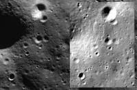
By way of comparison, this is just a completely random section of one of the OHRC images (left), with a screenshot from the same area of the LRO quickmap (right). I haven't adjusted the OHRC image in any way. Distance across the image is about 250m.
|
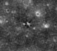
Posted by: Ohsin Feb 8 2021, 06:37 PM
A new image from Chandrayaan-2 OHRC has been released in response to a Right To Information query (bit like FOIA requests). ISRO claims it to be Vikram's "landing site" post landing attempt.
https://old.reddit.com/r/ISRO/comments/lfdo0z/image_of_crashed_vikram_lander_and_names_of/
Posted by: Phil Stooke Feb 8 2021, 09:19 PM
Hi, Ohsin. I can't see the images in this link - is it possible to post them directly here?
Phil
Posted by: Ohsin Feb 8 2021, 09:30 PM
Attaching them as is.

|

|
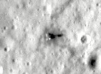
Posted by: Phil Stooke Feb 9 2021, 01:35 AM
Thank you! That is very useful. It enables this comparison with the post-impact LRO image from this site:
http://lroc.sese.asu.edu/posts/1131
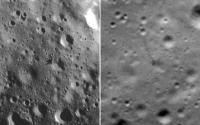
|
This object is the one a bit south of the impact site identified in that LROC blog post, the object which left a visible trail on the surface as it rolled away from the crash. The new image is notable for its superb resolution and sharpness, and it seems to resolve the track as a string of pits as if the object was bouncing (or had a very irregular shape as it rolled).
How I would love to see pictures like this of every landing and impact site on the Moon!
Phil
Posted by: Shan Feb 9 2021, 02:41 AM
http://lroc.sese.asu.edu/posts/1131
|
|
This object is the one a bit south of the impact site identified in that LROC blog post, the object which left a visible trail on the surface as it rolled away from the crash. The new image is notable for its superb resolution and sharpness, and it seems to resolve the track as a string of pits as if the object was bouncing (or had a very irregular shape as it rolled).
How I would love to see pictures like this of every landing and impact site on the Moon!
Phil
Phil, that's one of the engines which got separated at the first contact point, you can see the exhaust plume much more visible in this one.. (Oct 2019 image) whereas the one posted on LRO is Nov 2019 image where the plume is not that much visible due to lighting conditions..
Not sure what exactly happened during last few minutes of Vikram's landing, my view is the central engine would have got separated..only if the Vikram lander's telemetry is intact it can answer it for itself..
|
Posted by: threadworm Mar 18 2021, 07:01 AM
Has anyone had any success with Chandrayaan-2's orthographic/DTM combination, in terms of 3D imagery?
I've produced 3D models in the past with other missions with QGIS, but the 3D plugin just doesn't want to play. I've also had a go with Blender, but I'm not experienced with it so may not be doing it right!
Posted by: threadworm Mar 20 2021, 10:30 AM
Managed to answer my own question, partially at least.
For reasons best known to itself the DTM file was ridiculously exaggerating the vertical extent of the model. I found that my changing the vertical exaggeration in the Qgis2threejs plugin to somewhere around 0.00004 gave sensible results. There is a 'nodata' value of -32768, and I wonder if it's reading that in?
The resulting model looks a little 'lumpy', at least in this representation of part of Hadley Rille, and I'm not sure if that's a feature of the DTM itself or the processing its had to go through to get it presentable.
|
Posted by: Shan Mar 22 2021, 03:57 AM
For reasons best known to itself the DTM file was ridiculously exaggerating the vertical extent of the model. I found that my changing the vertical exaggeration in the Qgis2threejs plugin to somewhere around 0.00004 gave sensible results. There is a 'nodata' value of -32768, and I wonder if it's reading that in?
The resulting model looks a little 'lumpy', at least in this representation of part of Hadley Rille, and I'm not sure if that's a feature of the DTM itself or the processing its had to go through to get it presentable.
|
|
It seems they had some calibration issues with some instruments onboard..(OHRC was not calibrated first properly which gave blurry images but the images from Feb2020 were good).. I believe that's the case here also..Only ISRO can answer on that..
Posted by: threadworm Mar 23 2021, 05:00 PM
I've been through all of the Orthographic/DTM combinations and produced a (very) rough guide as to what's covered in what they've released so far. I've also compiled a spreadsheet showing the latitude/longitude if anyone wants that. It doesn't hit many things of interest, though it does cover the Apollo 17 SIV-B impact site and also Luna 21.
|
Posted by: threadworm Mar 30 2021, 07:34 PM
|
|
Apollo 14's lunar module in the calibrated TCM images ch2_tmc_nca_20200207T0122596445_d_img_m65 and ch2_tmc_ncf_20200207T0122596445_d_img_m65. The astronaut trails westward towards the ALSEP are clear, and those heading out and back from Cone crater can just be made out.
Posted by: Ohsin Jul 17 2021, 06:21 AM
Few more OHRC images have been released.
https://pradan.issdc.gov.in/pradan/
Posted by: threadworm Jul 28 2021, 09:47 PM
Ranger 9's impact point, from file ch2_tmc_nrf_20200107T1218554551_d_img_d18.
Working my way (slowy) through the TMC images they've added, so far they are frustratingly close to, but just missing, Apollo sites (other than the Apollo 14 one I posted earlier).
|
Posted by: Phil Stooke Jul 29 2021, 12:32 AM
Hi Threadworm. That image doesn't seem to match the pattern of craters around the Ranger 9 impact site. I have attached an LRO NAC image of the Ranger 9 crater (confirmed by comparing the Ranger 9 images taken just before impact). The two bright-rimmed craters and other bright dots in your image should be visible but are not. If you post a wider context image we may be able to see where your feature is.
Phil
|
Posted by: threadworm Jul 29 2021, 08:52 AM
Phil
|
|
Apologies. I got carried away - that should have read Ranger 8!
Posted by: Phil Stooke Jul 29 2021, 05:44 PM
That works! Here is a version with much of the stripe pattern removed. It would be nice to see this imaged by the high resolution camera.
Phil
|
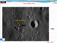
Posted by: Ohsin Sep 3 2021, 06:32 PM
In a virtual talk held today, Director of Space Applications Centre, ISRO showed an OHRC image of Apollo 11 landing site.
https://youtu.be/T8oV-Kx26no?t=3610
We were notified by u/Harshdeep_2021 on https://redd.it/ph3p9l.
|
Posted by: Hungry4info Sep 3 2021, 09:13 PM
Slightly higher quality.
|
Posted by: threadworm Sep 6 2021, 04:03 PM
It may well be worth tuning in to this:
https://www.youtube.com/watch?v=fF7vdqDfOwU
scheduled for 05:30 GMT on the 7th of September.
Posted by: Ohsin Sep 7 2021, 06:50 AM
PRL hosted portal for XSM payload with near real-time data plot.
https://www.prl.res.in/ch2xsm/
Posted by: threadworm Sep 8 2021, 06:44 AM
The presentation wasn't what I'd hoped, and no real clues as to when more data will be released, but for what it's worth there are three documents available here with scientifric results in them:
https://www.isro.gov.in/chandrayaan-2-science-and-data-product-documents
Of the three, the larger third document is probably of more interest, as it contains much of the other two and more pretty pictures
Posted by: threadworm Sep 22 2021, 04:15 PM
Another couple of hundred TMC files released today.
Posted by: threadworm Sep 22 2021, 09:22 PM
A nice feature they've released along with the files is a collection of shape files - there are links on the TMC and OHRC browse and download pages.
Those shape files can be imported into Google Earth, which is a much easier way of seeing where they've covered!
Posted by: Ohsin Sep 23 2021, 06:42 PM
These shapefiles can be imported as a layer into Quickmap as well!
https://quickmap.lroc.asu.edu/
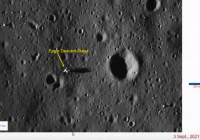
Meanwhile in another webinar they shared OHRC image of Apollo-12 landing site taken on 5 April 2021.
https://youtu.be/vQj6oKgKeKc (https://old.reddit.com/r/ISRO/comments/pptbep/day_1webinar_series_space_technology/)
https://i.imgur.com/kyxOJ5q.png gives rough location of possible sites. Compared with OHRC shape files it kind of narrows down location to match-up this visual of probable landing site of Chandrayaan-3 lander (~115×92 meters) 
|
Posted by: Phil Stooke Sep 24 2021, 06:25 AM
Very interesting. Thanks for pointing it out. I see that another part of the presentation had a map with two points representing the Chandrayaan 3 landing sites (prime and backup), and they are not the same as the Chandrayaan 2 sites. They are both fairly close to the CH2 prime site but far from the CH2 backup site. That map is very low resolution but if it is superimposed on the original US Air Force mosaic which was its base the sites can be located better:
|
And with a bit of a mind-flip we get this:
|
I hope to learn more about the specific sites closer to launch.
Phil
Posted by: Ohsin Sep 24 2021, 07:28 AM
Yes Phil I should've mentioned that and we discussed it on reddit, those blue dots are what narrowed down the relevant OHRC data regions and provide clues to where we should look for CY3 landing site.
Posted by: Phil Stooke Sep 24 2021, 03:32 PM
I didn't notice the Reddit discussion - thanks. So it looks like my southern dot should be inside Boguslowsky crater. I moved it from the rim to a more level spot outside but I should have gone inside.
Phil
Posted by: threadworm Oct 6 2021, 03:31 PM
Another few hundred files released yesterday from the TMC camera. The updated collection of shape files show most of the new coverage is the far side, and higher northern/southern latitudes.
Posted by: Ohsin Nov 15 2021, 11:22 AM
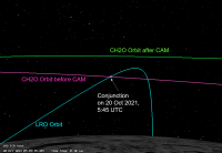
https://www.isro.gov.in/update/15-nov-2021/chandrayaan-2-orbiter-ch2o-performs-evasive-manoeuvre-to-mitigate-critically
Chandrayaan-2 Orbiter (CH2O) performs an evasive manoeuvre to mitigate a critically close approach with LRO
A very close conjunction between Chandrayaan-2 Orbiter (CH2O) and Lunar Reconnaissance Orbiter (LRO) of NASA was expected to occur on 20 Oct 2021 at 05:45 UTC (11:15 am IST) near the Lunar North pole. Over a span of one week prior to the conjunction, analyses by both ISRO and JPL/NASA consistently showed that the radial separation between the two spacecraft would be less than 100 m and the closest approach distance would be only about 3 km at the aforementioned time of closest approach. Both the agencies deemed that the situation warranted a collision avoidance manoeuvre (CAM) to mitigate the close approach risk, and it was mutually agreed that CH2O would undergo the CAM. The manoeuvre was scheduled on 18th October 2021, it was designed to ensure a sufficiently large radial separation at the next closest conjunction between the two spacecraft. The CAM was executed nominally at 14:52 UTC (8:22 pm IST), on October 18th. After orbit determination of CH2O with post-manoeuvre tracking data, it was reconfirmed that there would be no further close conjunctions with LRO in the near future with the achieved orbit.
It may be noted that like CH2O, LRO orbits the Moon in a nearly polar orbit and hence, both the spacecraft come close to each other over the Lunar poles. It is common for satellites in Earth Orbit to undergo Collision Avoidance Manoeuvres to mitigate collision risk due to space objects including space debris and operational spacecraft. ISRO regularly monitors such critical close approaches and execute CAMs for its operational satellites whenever the collision risk is assessed to be critical. However, this is the first time such a critically close conjunction was experienced for a space exploration mission of ISRO which necessitated an evasive manoeuvre.
The event highlights the importance of continual assessment of close approach situations for Lunar and Martian missions, and the fact that effective mitigation of close approach risk involves close coordination and synergy among different space agencies.
|
|
Posted by: Steve G Feb 4 2022, 01:29 AM
There's no section yet for Chandrayaan III, but launch is set for this August.
https://spacenews.com/india-targets-august-launch-for-chandrayaan-3-lunar-lander/
Posted by: Ohsin Feb 4 2022, 02:24 AM
Spacenews linking to tweet as source. Here are official links.
http://164.100.24.220/loksabhaquestions/annex/178/AU59.pdf
https://pib.gov.in/PressReleasePage.aspx?PRID=1795030
And per discussion above landing site is not same as the SN article suggests.
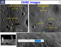
Posted by: threadworm Feb 22 2022, 08:46 AM
OHRC update covers the Apollo 11 and 12 sites:

Posted by: Shan Feb 22 2022, 01:48 PM
Thanks for posting it here! Going to process the image via ISIS
Was checking everyday for this image and for the last 2 days didn't log into Chandrayaan2 portal..
|
|
|
Posted by: Phil Stooke Feb 22 2022, 08:13 PM
These images are absolutely stunning. Let's hope for more sites imaged like this.
Phil
Posted by: Explorer1 Feb 22 2022, 08:34 PM
Great time of lunar day to take images as well; the shadow of the legs seals the deal for me; the detail of an oblique view without the loss of resolution.
Posted by: kenny Feb 27 2022, 09:36 PM
Stunning, as Phil says, and the most detailed view of these two sites ever.
52 years later, the surficial disturbance made by the walking astronauts is still visible.
Of course, it is not their actual footprints, but the wider area sprayed by dust lifted by their movements.
Undisturbed surface, bleached by millennia of solar radiation, is lighter in tone. Movement uncovers the darker lower levels.
Can anyone advise the current orbital inclination of Chandrayaan 2?
I suspect near equatorial, meaning it can pass over Apollo 11, 12 and perhaps 14.
But not 15,16 or 17?
Posted by: Phil Stooke Feb 28 2022, 03:30 AM
No, it is nearly polar so it could view the Chandrayaan 2 landing site at 70 degrees south.
Phil
Posted by: threadworm Mar 2 2022, 06:18 PM
Another update today, this time the TMC camera, some 330+ files.
No new Apollo coverage, but 111 of the locations are covering the south polar region - at least that's what the shape filename and the appearance of the shape file when loaded into QGIS suggests. However the supplied shape files are proving difficult to load into Google or the LRO map to generate locations. Someone with more expertise than I may be able to get at the shapefile contents and get coordinates from them. Good luck!
Posted by: threadworm Mar 2 2022, 06:34 PM
52 years later, the surficial disturbance made by the walking astronauts is still visible.
Of course, it is not their actual footprints, but the wider area sprayed by dust lifted by their movements.
Undisturbed surface, bleached by millennia of solar radiation, is lighter in tone. Movement uncovers the darker lower levels.
Can anyone advise the current orbital inclination of Chandrayaan 2?
I suspect near equatorial, meaning it can pass over Apollo 11, 12 and perhaps 14.
But not 15,16 or 17?
The images covered so far show that the TMC has covered the Apollo 14 site (just). There are also TMC passes published just west of Taurus-Littrow, likewise just west of Apollo 16 and either side of the Apollo 15 site - very frustrating!
My gut feeling is that the OHRC imaging of Apollo 11 and 12 was a 'target of opportunity' thing, seeing as the LMs are pretty much dead cetnre of the images!
Posted by: Ohsin Jul 9 2022, 03:28 AM
TMC-2 imaged Rocket Booster Impact on the Lunar Surface
On 4th March 2022, a spent rocket booster hit the lunar surface near the Hertzsprung crater, which is in the far side of the Moon. The impact created a double crater which is ~28m wide. Terrain Mapping Camera 2 (TMC-2) onboard Chandrayaan-2 imaged the far side of the Moon in April 2022 and identified the impact site.
TMC-2 imaged Rocket Booster Impact on the Lunar Surface
The above image shows the comparison between the regions which is imaged before impact (21st February 2022) and after impact (3rd April 2022). The yellow arrow mark indicates the new crater formed due to the impact. The spatial resolution of TMC-2 is 5m and the image is zoomed four times.
https://www.isro.gov.in/update/08-jul-2022/tmc-2-imaged-rocket-booster-impact-lunar-surface

Posted by: threadworm Sep 28 2022, 08:59 AM
|
Update to the TMC listing this morning, including one pass that covers Apollo 17. This is my first attempt at revealing the detail - the dark spot is disturbed ground around the lunar module.
Interestingly, the shape file list has quite a few files missing, notably the one just west of Apollo 16's landing site.
No new OHRC files, but they may follow soon.
Posted by: threadworm Oct 1 2022, 08:01 AM
And indeed some more images have been added to the OHRC list. Again, odd things going on. The image count has gone up by 6, but in reality there seem to be 20 new ones (10 pairs of raw/calibrated). A hefty chunk of those pairs are, according to the shapefiles that accompany the release) on exactly the same spot (somewhere over the far side).
In addition to the TMC files near Apollo 16's site that have gone astray, the ones that cover Apollo 14 are also gone. I can only think things aren't going well with whoever is adding files to their site!
My top tip is that if you find a file that covers are area of interest, download it!
Posted by: Ohsin Dec 23 2022, 02:22 PM
New CY2 payload data release:
https://twitter.com/Akdixit131/status/1606286561221320704
Posted by: threadworm Jan 5 2023, 04:06 PM
Pretty hefty data dump under way at the moment. 2000+ TMC-2 files added (so far).
No update to the shapefiles as yet to see where the new coverage is, but hopefully that'll come soon. No change in the number of OHRC files yet, but they tend to do them one instrument at a time!
Edited to add: they've added more files today than in the entire time their data site has been live. Currently standing at over 4000 new files.
Posted by: threadworm Jan 6 2023, 07:07 PM
The shape files are now available.
Not much additional coverage in terms of the Apollo missions, but there is this of the Apollo 16 site:
|
That's a first go at teasng out the detail (the dark is admittedly a bit over-exaggerated), but it probably won't get much better.
No sign yet of any new OHRC uploads.
Posted by: Ohsin Oct 4 2023, 02:17 PM
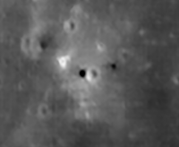
New OHRC data just dropped.
Posted by: Ohsin Nov 19 2023, 02:39 PM
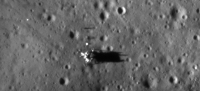
From a recent talk by SAC Director Nilesh M Desai. Before and after images of Chandrayaan-2 lander impact location.
https://www.youtube.com/watch?v=nivAGxeDaSc&t=2075s
|
|
|
Posted by: threadworm Jan 16 2024, 08:00 AM
ISRO have added a searchable map for OHRC and TMC data, with download links for any returned results. If you turn on crater names some anthropogenic features are shown, but not others.
Posted by: Phil Stooke Jan 17 2024, 05:14 PM
I tried to find this but couldn't (one possible link would not open for me). Can you provide a link?
Phil
Posted by: Olympusmonsuk Jan 17 2024, 07:14 PM
Phil
I had tye same problem but eventually got to it at https://chmapbrowse.issdc.gov.in/MapBrowse/
Hope this helps.
Robin
Posted by: Phil Stooke Jan 18 2024, 07:47 PM
The small number of OHRC images is startling. So many things I would love to see in its images!
Phil
Powered by Invision Power Board (http://www.invisionboard.com)
© Invision Power Services (http://www.invisionpower.com)