Printable Version of Topic
Click here to view this topic in its original format
Unmanned Spaceflight.com _ Spirit _ The Return to Home Plate
Posted by: jamescanvin Feb 6 2007, 03:58 AM
Seems like a good time for a new thread.
Spirit should be on her way back to Home Plate fairly soon. To help plan this, back on sols 1081 and 1089 a long baseline anaglyph was taken in that direction, here is my attempt to put it together.
http://www.physics.usyd.edu.au/~jcanvin/mer/index.html#A1081
James
Posted by: Tesheiner Feb 8 2007, 09:05 AM
> Spirit should be on her way back to Home Plate fairly soon.
Perhaps she's on the move right now! The plan for tosol (1102) includes driving and taking a "post-drive" 180º navcam mosaic centered at 288º (looking back to Low Ridge).
I'm pretty convinced they won't move towards Tyrone so this could be the first move on the return to Home Plate.
Stay tuned.

Posted by: Tesheiner Feb 8 2007, 02:58 PM
Yes!
Spirit did a sort of U-Turn and is now positioned to drive (backwards, off course) towards Home Plate.
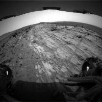
Rhaz: http://nasa.exploratorium.edu/mars/spirit/rear_hazcam/2007-02-08/2R224199805EFFASHLP1312R0M1.JPG
Fhaz: http://nasa.exploratorium.edu/mars/spirit/forward_hazcam/2007-02-08/2F224199753EFFASHLP1212R0M1.JPG
|
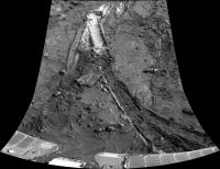
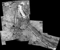
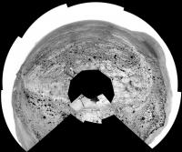
Annotated navcam mosaic (sol 1096)
Posted by: jvandriel Feb 9 2007, 08:24 PM
Added 2 images.
The L0 Navcam view from Sol 1096 and Sol 1098.
jvandriel
|
|
Posted by: Stu Feb 9 2007, 09:53 PM
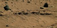
Loving the ripples in the dust as we head back to HP...
|
Posted by: dilo Feb 10 2007, 09:27 AM
Based on last jv pano:
|
|
Posted by: Tesheiner Feb 10 2007, 08:58 PM
My attempt on the 360º navcam panorama (half-size) taken on sol 1103.
|
|
---
FWIW, next driving sol is 1106.
Posted by: Phil Stooke Feb 11 2007, 10:43 PM
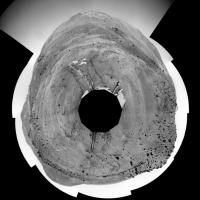
My polar version of the newest pan.
Phil
|
Posted by: Tesheiner Feb 12 2007, 08:37 PM

There are no images from this sol on today's downlink so obviously the plan has changed.

Perhaps tomorrow?

Posted by: Zeke4ther Feb 13 2007, 04:16 AM
New update confirms drive back to Home Plate
http://marsrovers.jpl.nasa.gov/mission/status.html
Robin
Posted by: Stu Feb 13 2007, 08:45 AM
Said it before... let me at those rocks!!!
|
|
Posted by: fredk Feb 13 2007, 04:41 PM
Stu, those are stunning - you've nailed that colour pretty much dead on. Those could've been press release images. 
Posted by: Tesheiner Feb 13 2007, 05:39 PM
Ok, Spirit is on the move again.
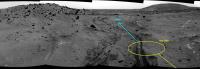
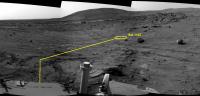
Based on the last http://nasa.exploratorium.edu/mars/spirit/forward_hazcam/2007-02-13/2F224645054EFFASL5P1212R0M1.JPG and http://nasa.exploratorium.edu/mars/spirit/rear_hazcam/2007-02-13/2R224645105EFFASL5P1312R0M1.JPG images from sol 1107, I would place the rover here (see image).
|
Posted by: Stu Feb 13 2007, 10:43 PM
Thanks Fred, I was quite pleased with them. Think I'm getting better 
Here's a view from a couple of days ago I completely forgot about...
|
Posted by: Tesheiner Feb 14 2007, 11:39 AM
Here's the "post-drive" navcam mosaic (4x1) taken on sol 1107.
|
Will Spirit drive over those old tracks on the way back to Home Plate?
Edited: Another question: At which point in HP do you think they will re-start the science campaign? North side, NE corner, East side?
Posted by: djellison Feb 14 2007, 12:06 PM
Given a broken wheel - I'm really rather pleased with the length of that drive - should be back at HP fairly soon.
Doug
Posted by: Tesheiner Feb 14 2007, 01:52 PM
I think the tricky manouvers on five wheels are only those related to positioning the rover for IDD work.
Straight driving for "long" distances was already seen when Spirit drove back from Tyrone to the winter haven on sols 803 & 805.
Posted by: kungpostyle Feb 14 2007, 03:54 PM
Sorry if this has already been posted
http://www.space.com/missionlaunches/070214_smart_rovers.html
I didn't want to start a topic for it.
Posted by: general Feb 15 2007, 08:47 PM
http://qt.exploratorium.edu/mars/spirit/rear_hazcam/2007-02-15/2R224823033EFFASNUP1312L0M1.JPG
Looks like Spirit is enjoying herself - trying to build a sand castle 
Pushing herself up against that mound - and a stone in her jammed wheel 
http://qt.exploratorium.edu/mars/spirit/forward_hazcam/2007-02-15/2F224830541EFFASNUP1214L0M1.JPG
Posted by: Stu Feb 15 2007, 09:22 PM
Just a bit of messing around while nursing a very sick dog (see avatar... ) Operation for her tomorrow, so have to do something to take my mind off it... 
|
Posted by: general Feb 15 2007, 09:53 PM
Sorry to hear that. Beautiful collie is it. Sure hope she'll be fine.
Posted by: Shaka Feb 16 2007, 12:58 AM
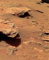
Hmmm. That slab of stuff directly in front of us seems to have an open, porous surface. Could it be a third kind of laminar "sulfate rock" after the granular and non-granular layers we were studying back at King George Island? The sedimentary history around here is continuing to complicate.
Posted by: Reckless Feb 16 2007, 08:56 AM
Hi Stu hope all goes well with your dog (sorry I don't know his/her name.)
Shaka hello, those rocks do look new and so porous that they could almost be pumice.
I hope the stone in bad wheel doesn't make thing worse for Spirit.
Roy F
Posted by: kenny Feb 16 2007, 09:32 AM
Doug
I get the impression from the latest Flight Director's report (Feb 15) that they're headed for Mitcheltree Ridge first, rather than Home Plate as we've heard to date.
http://www.jpl.nasa.gov/missions/mer/flightdir.cfm
Posted by: Gray Feb 16 2007, 02:01 PM
Stu,
Let us know how things go with the operation.
Dogs are special companions.
Posted by: ustrax Feb 16 2007, 03:22 PM
Stu, I hope everything goes well.
Lhoba sents her best wishes.
Dogs...We can't live without them...
Posted by: Tesheiner Feb 16 2007, 03:47 PM
My impression is that they will spend the weekend analysing the rock right in front of the rover and then move directly to HP. If the current location is considered part of Mitcheltree Ridge or not is something I don't know.
Posted by: Stu Feb 16 2007, 06:36 PM
Thanks for all the support guys re Amber's operation earlier today, I really appreciate it. Not embarrassed to admit I've been in pieces all day, ever since leaving Amber at the vet's first thing this morning. But happy to be able to report that our 14 year old collie made it through the kidney biopsy op, and is now sleeping off the anaesthetic in the vet's, on a drip, warm and safe under a sheepskin blanket. The op uncovered definite kidney damage, which the tests on the biopsy sample will hopefully show can be treated with appropriate medication/diet etc.
I love this dog to bits, not ashamed to admit it,though I know "non dog people" will find it hard to understand how something like this can get to you, but that's ok. She's been sitting or more usually sleeping by my side as I've sat here looking at MER pictures for the past 3 years. I actually use Amber in my school and public Outreach talks a lot, and often sneak her into pictures, just for the sake of it. This is one I use to see if anyone actually sees it and asks "Is that a real photo..?" 

|
Thanks again guys. I won't go on about this again.
Posted by: Stu Feb 16 2007, 07:57 PM
Been backtracking a bit and hey, look where we were a year ago...

|
Can't wait to get back amongst all those rocks! Shouldn't be long now...
Posted by: Tesheiner Feb 17 2007, 09:08 AM
The MER website has an http://marsrovers.jpl.nasa.gov/mission/status_spiritAll.html#sol1104 from the 16th Feb.
Among other things, Spirit suffered a reboot and will be moving towards HP on sol 1104.
Posted by: jvandriel Feb 17 2007, 12:48 PM
Here is the 360 degree panoramic view taken with
the L0 Navcam on Sol 1107 and Sol 1108.
jvandriel
|
|
Posted by: jvandriel Feb 17 2007, 01:08 PM
The L7 Pancam view in the drive direction on Sol 1109.
jvandriel

|
Posted by: Stu Feb 17 2007, 08:58 PM
Rocks getting more interesting the closer we get...
|
|
Posted by: Phil Stooke Feb 18 2007, 12:22 AM
Here is jvandriel's latest pan in polar form.
Phil
|
Posted by: CosmicRocker Feb 18 2007, 07:31 AM
Posted by: Floyd Feb 19 2007, 08:29 PM
Nothing on Exploratorium for the past two days--does anyone know if we have gotten any data from Spirit recently? Hopefully not another computer reset. Maybe she has just gone shopping for a new set of wheels, it's Presidents Day (An American tradition to buy stuff on this holiday, particularly cars).
Posted by: Tesheiner Feb 19 2007, 08:50 PM
Sol 1113 is finishing but I don't know if the evening downlink window was already done or not.
Truly the imaging plan for these weekend was very "light" but I would expect in that case some older images to get their way through the downlink pipeline.
I really hope there was no other reset; who knows. What I know is that tomorrowsol (1114) looks to be driving sol i.e. move towards Home Plate.
We will see.
Posted by: Stu Feb 19 2007, 09:54 PM
Now that I think I've just about managed to get half-decent colours with my software, in advance of Spirit's triumphant, wounded-wheel dragging return to Homeplate, I've been going back over old images of the feature and seeing what I could do... looking forward to views like this again...

|
Posted by: Marz Feb 19 2007, 10:21 PM
Truly the imaging plan for these weekend was very "light" but I would expect in that case some older images to get their way through the downlink pipeline.
I really hope there was no other reset; who knows. What I know is that tomorrowsol (1114) looks to be driving sol i.e. move towards Home Plate.
We will see.
I think the weekend observations were mostly with mini-TES, but usually there's some other data from the navcam during these sessions. If a drive is planned, then that must be a good sign all is well... I hope.
Today is a holiday in the USA? Nobody told me!
Posted by: Tesheiner Feb 20 2007, 02:17 PM
Nothing new, yet. Sol 1114 images should hit the exploratorium NET 20:30UTC.
Ahh, good old times when Spirit had all six wheels in good shape.
Posted by: Marz Feb 20 2007, 04:03 PM
Ahh, good old times when Spirit had all six wheels in good shape.
Yup, Exploratorium's downlinked a new batch this morning.
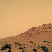
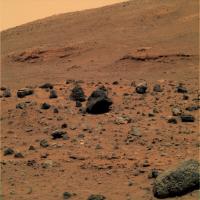
Looks like some nice variety of rocks on Mitcheltree:I wonder if the top-center rock is a meteorite or the very-vesiculated scoria we've seen? Bottom left is an eroded chunk in the suspicious shape of a coral head, but I suppose is related to the sulfate+ash rocks around here?
http://qt.exploratorium.edu/mars/spirit/pancam/2007-02-20/2P225169216EFFASNUP2456L7M1.JPG
And perhaps they are more interested in what appears to be a welded tuff:
http://qt.exploratorium.edu/mars/spirit/pancam/2007-02-20/2P225171986EFFASNUP2560L5M1.JPG
Posted by: Stu Feb 20 2007, 07:39 PM
Like you said, nice variety of rocks...
|
|
Posted by: Floyd Feb 21 2007, 12:49 AM
New set of images at http://qt.exploratorium.edu/mars/spirit/.
Posted by: Tesheiner Feb 21 2007, 10:05 AM
Let's see if we may have at least two more driving days before the weekend so Spirit could be at Home Plate's east face soon. Given the current downlink times I'm afraid Spirit is on restricted sols.
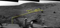
Here is the rover current location (approximate) as seen from a navcam mosaic taken on sol 1103.
|
Posted by: Stu Feb 22 2007, 08:22 AM
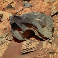
Still playing about with carefully re-examining old Homeplate images, and now I really want to go back to this rock... I don't think they looked at it carefully enough last time.
|
But I know, Spirit was in rather a rush...
Posted by: mhoward Feb 23 2007, 03:49 AM
Sol 1116 Navcam equirectangular:
http://www.flickr.com/photos/marscat/399393616/
(I don't have access to PTGui at the moment, so the stitch is not the best.)
Posted by: dilo Feb 23 2007, 07:05 AM
Thanks, Michael.

|

|
Vertical (2.5cm/pixel) and Pseudo-Polar - as usual.
Posted by: Phil Stooke Feb 23 2007, 02:30 PM
Here's my version of mhoward's pan in polar form.
Phil

|
Posted by: Stu Feb 24 2007, 08:07 AM
Okay, Spirit is definitely writing grafitti in the dust now...

|
Posted by: Tesheiner Feb 24 2007, 11:45 AM
First I thought you've touched the original image, then I said to myself: "No, it's really there! What's that!".
Then I realized those "scratches" were wheel marks...
Posted by: jvandriel Feb 24 2007, 01:03 PM
mhoward,
here is my version of the Sol 1116 L0 navcam pano.
With the help of MichaelT's anti vignetting program
and Paintshop Pro 7 and of course Autostitch. 
jvandriel
|
|
Posted by: Stu Feb 25 2007, 10:15 AM
Luvverly, luuvverly rocks...

|
Posted by: centsworth_II Feb 25 2007, 04:16 PM
Yes. But I'm itching to see the intact layers of Homeplate up close again.
Posted by: alan Feb 25 2007, 09:11 PM
Image dimensions: 666 x 666
More like: Evil. Satanic rocks

Posted by: Tesheiner Feb 26 2007, 11:21 AM
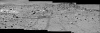
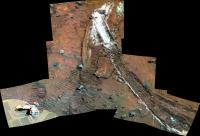
Spirit is driving parallel to the old tracks from sols 770-780. Here is the "post-drive" navcam mosaic from sol 1119 after moving 6m northwards.
|
|
Posted by: algorimancer Feb 27 2007, 01:55 PM
>Spirit is driving parallel to the old tracks from sols 770-780.
I've been wondering about that. I had rather expected that Spirit might circle around the southwest side of the plate (something new), yet the current route map seems to indicate that it is very nearly retracing its route about the northeast side. There was that intriguing blueberry-looking feature seen from the sol 764 (or thereabouts) location which I've been wanting to get back to, but retracing the same route has caught me a bit by surprise.
Posted by: Ant103 Feb 27 2007, 02:59 PM
A late picture post because I can't acces to the web via my laptop (losing my wifi usb key, but now, I've got a pcmcia card).
So, here is Bellingshausen rock, on Sol 1108 :
http://astrosurf.com/merimages/Spirit/Panoramas_couleur/Bellingshausen-Sol1108.jpg
Posted by: Tesheiner Feb 28 2007, 09:31 AM
Me too.
I'm still wondering *where* they will start the science campaign. It would be a nice surprise for me if they retrace the route back to the NW corner. Yes, there are a *lot* of things to study there.
BTW, Spirit drove another 10m on sol 1121, retracing the tracks again .
Posted by: centsworth_II Feb 28 2007, 04:05 PM
My impression is that during the race to get to a good wintering site, Spirit passed many
potential science targets with no time to study them. Steve Squyres even mentioned a
particular, strange rock he couldn't wait to get back to. It's not at all surprising that they
are retracing their steps. The spot where Spirit first encountered Home Plate may turn
out to be the most impressive that HP has to offer in terms of layering. Spirit spent much
too short a time there.
Posted by: Tesheiner Mar 1 2007, 11:05 AM
The http://www.planetary.org/news/2007/0228_Mars_Exploration_Rovers_Update_Spirit.html on The Planetary Society has a nice description of the driving and science strategy once Spirit reaches Home Plate. Here is an extract.
"We have good PanCam coverage of the edge of Home Plate, where we made the turn to McCool Hill last year, and we have another good image dataset of the layering somewhat to the north, so the idea now is to take a little jog to north to fill in that gap in between so we have high-resolution imaging of the exposed edges and face of this side of Home Plate," expounded Banerdt. "Once we finish that, we will head south and go up the edge to get back on top of Home from the southern edge."
...
Posted by: Shaka Mar 2 2007, 06:24 AM
Hmm... Looks like an interesting proliferation of the King George - Troll units up off the starboard bow:

|
Posted by: dilo Mar 2 2007, 06:39 AM
Cool view of the place where Spirit spent 8 months...
http://qt.exploratorium.edu/mars/spirit/navcam/2007-03-01/2N226066014EFFASWCP0656R0M1.JPG
Posted by: Shaka Mar 2 2007, 06:57 AM
All views of Mars are cool at this time of year, Dilo, but they will be warming up in the coming months*.
*(Sorry, I don't know how to convert the term months into revolutions of Phobos and Diemos.) 
Posted by: Tesheiner Mar 2 2007, 09:33 AM
Here is the 225º navcam mosaic facing Mitcheltree ridge. Sol 1123.
|
|
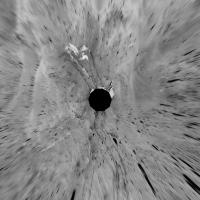
Posted by: Phil Stooke Mar 2 2007, 02:00 PM
Tesheiner's partial pan in polar form...
Phil

|
Posted by: Ant103 Mar 2 2007, 03:00 PM
Nices views here I seen
On the road to Home Plate, a two-framed-panorama taken toward SW horizon with Grissom Hill, on Sol 1110 :
http://astrosurf.com/merimages/Images_de_spirit-2007.html#Sol1110
And desktop :
http://astrosurf.com/merimages/Desktop/Monticule&GrissonHill-Sol1118-desktop.png
I began to have such desktop pictures to make a calendar (for 2008 ).
Posted by: RobertEB Mar 2 2007, 03:41 PM
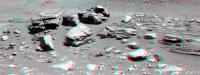
Ant, did you see the petrafied ant Spirit found http://marsrovers.jpl.nasa.gov/gallery/all/2/p/1108/2P224728976EFFASL5P2559L2M1.JPG
Its the rock on the right middle part of the screen
Posted by: jvandriel Mar 4 2007, 10:59 AM
and here is the complete 360 degree panoramic view
from Sol 1123.
Taken with the L0 Navcam.
jvandriel
|
|
Posted by: jvandriel Mar 4 2007, 12:15 PM
Another nice view cutout of the Sol 1123 Navcam
Panorama and coloured.
jvandriel

|
Posted by: Stu Mar 6 2007, 03:28 PM
BIG sky...

|
Posted by: Ant103 Mar 6 2007, 06:22 PM
Yes Stu
Time to update my sky following :
http://astrosurf.com/merimages/Spirit/Inclassables/EvolutionCielOpacite-Sols972-980-1009-1013-1024-1041-1064-1087-1122.jpg
Dust quantity is decreasing.
Posted by: dilo Mar 7 2007, 07:00 AM
Sol 1126, right Navcam:
|
|
I love this view, really something different from last months (even if not really new!)
Posted by: Gray Mar 7 2007, 02:51 PM
I agree. I like the way the strata in the foreground appear to sweep around to the left; and behind it the big dark expanse of El Dorado.
Posted by: fredk Mar 7 2007, 07:04 PM
Interesting changes on the solar panels between these two shots 4-5 minutes apart, sol 1125:

|
They don't seem to be reflections, since they are both on the solar cells and off them. My guess is very small clumps of dust set loose in the rat by it's movement (you can just see the rat moving in the upper left).
It's interesting though that not only do we see new spots/streaks in the second frame, but some spots that were in the first frame have disappeared in the 2nd! I suppose if they are dust, wind could have dissipated them between frames.
Posted by: Phil Stooke Mar 7 2007, 07:34 PM
Reflections of the sun off the mast onto the deck?
Phil
Posted by: djellison Mar 7 2007, 08:43 PM
Reflections off the IDD itself perhaps?
Doug
Posted by: centsworth_II Mar 7 2007, 09:57 PM
I think the solar cell and non-solar cell surfaces are becoming similar in reflective properties
as the layer of dust on them thickens. It looks to me like reflections moving from one spot
to another as the "mirror" causing them moves.
Posted by: fredk Mar 8 2007, 12:26 AM
Agreed. Reflections onto the deck makes sense - not from the arrays.
Posted by: Steve Mar 8 2007, 03:21 AM
I see a reflection from the IDD into the camera causing glare. Especially likely with a very dusty camera lens.
Steve
Posted by: Tesheiner Mar 9 2007, 11:45 AM
I was reading again this part of the http://www.planetary.org/news/2007/0228_Mars_Exploration_Rovers_Update_Spirit.html.
(strikethrough and bold styles are mine)
On another drive Monday, Sol
"We have good PanCam coverage of the edge of Home Plate, where we made the turn to McCool Hill last year, and we have another good image dataset of the layering somewhat to the north, so the idea now is to take a little jog to north to fill in that gap in between so we have high-resolution imaging of the exposed edges and face of this side of Home Plate," expounded Banerdt. "Once we finish that, we will head south and go up the edge to get back on top of Home from the southern edge."
I'm wondering if "once we finish that" is this weekend and we may see Spirit doing a U-Turn this sunday/monday...
Edited: Perhaps it's time to activate the "Future (hypotetical) path" map layer again. Here is my bet.

|
Posted by: algorimancer Mar 9 2007, 01:56 PM
It just doesn't make sense to me to drive back south to get onto Home Plate, when Spirit is already sitting next to a spot where it previously drove off the plate and has therefore already surveyed. I suppose that they might have noticed something interesting in the edge further to the south, or that the intent is to do a complete clockwise jaunt around the plate. I'm sure there's a rationale, but I don't see it.
Posted by: Cugel Mar 9 2007, 01:59 PM
Your proposal would take Spirit along the eastern rim of HomePlate 3(!) times in a row...
A bit strange, isn't it. If you want to do a clockwise survey of the thing, why not do it from the inside?
So, drive a bit further North outside of HP, then cross the edge to get on top of it and then return South.
But it seems that the words of Mr. Banerdt are pretty cryptical (at least to me).
Posted by: Phil Stooke Mar 9 2007, 02:48 PM
This plan does have Spirit passing the edge of HP 3 times in this area, but the first 2 times it did not do a survey of the edge of the plate. A full stereo multispectral or miniTES survey has not been done along this edge.
Phil
Posted by: fredk Mar 9 2007, 03:18 PM
I had interpreted that report to mean that they were also interested in imaging the rim of HP from the outside all the way up to the sol 768 position or so.
Also, I think Squyres has talked about one particular rock on top of HP - I've forgotton the name, but I think it had to be http://marsrovers.jpl.nasa.gov/gallery/all/2/p/772/2P194897821EFFAPBCP2595L7M1.JPG at the sol 768 position. He sounded very eager to reexamine it.
Posted by: centsworth_II Mar 9 2007, 03:32 PM
Yes, there is Steve Squyres' rock. Also, in the update it is clear that
the rover planners were not yet sure to what extent they would stick
to the perimeter of Home Plate or cut across it to various parts of the
rim. I don't see any sign of the clockwise rounding approach.
Posted by: Tesheiner Mar 9 2007, 04:02 PM
> algorimancer: It just doesn't make sense to me to drive back south to get onto Home Plate
> Cugel: Your proposal would take Spirit along the eastern rim of HomePlate 3(!) times in a row...
Ok, the "Future route" in the map is mine, but it's just how I read (I may be wrong) Mr. Banerdt's words in the report i.e. drive north up to TBD then back south.
> Phil Stooke: This plan does have Spirit passing the edge of HP 3 times in this area, but the first 2 times it did not do a survey of the edge of the plate.
I would say "passing 3 times, but the first without doing a survey". They *are* doing a pancam survey on this pass but given the IDD status until a few sols ago I'm not sure if the next pass (south, if actually done) will include science or not.
> fredk: I had interpreted that report to mean that they were also interested in imaging the rim of HP from the outside all the way up to the sol 768 position or so.
Sol 786 or current position. That's the question, but I can't find a definitive answer on the report. The reference to that rock by S.S. may be a hint.
Posted by: Phil Stooke Mar 9 2007, 09:30 PM
On Sol 1123 Spirit passed the 7000 m mark.
Phil
Posted by: Tesheiner Mar 9 2007, 09:46 PM
Glad to know that. Thanks Phil.
I think it would be nice to include this odometer milestone on the route map, mostly because I have my doubts that we would see an 8 km mark.
Edited:
As of sol 1123 (March 1, 2007), Spirit's total odometry was 7007.84 meters (4.35 miles).
That places the 7000m mark almost at the spot corresponding to sol 1121.
Posted by: Stu Mar 10 2007, 01:28 PM
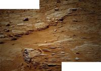
Fine layering detail at HP...

|
Posted by: Ant103 Mar 11 2007, 12:21 PM
Hi,
The fine layering that Stu describe
http://astrosurf.com/merimages/Images_de_spirit-2007.html#Sol1128
(I've made in the same time a little redraw of my website)
Posted by: Tesheiner Mar 11 2007, 01:46 PM
Spirit was on the move today (sol 1132), obviously heading north.
http://qt.exploratorium.edu/mars/spirit/navcam/2007-03-11/2N226864122EFFASY4P0645R0M1.JPG
Posted by: Shaka Mar 11 2007, 07:01 PM
Yeah, Tesh, it looks like Steve wasn't kidding about returning to 'Fuzzy' Smith. It'll be interesting to see what he does to it that he didn't do back around sol 772.
Posted by: climber Mar 11 2007, 07:48 PM
Spirit passed the 6000m mark on Jan 5th 2006 while Oppy was at 6503 barrely ahead of her. She then drove 3700m while Spirit drove these 1000m.
It's still glad to talk about kilometers instead of meters
Posted by: MaxSt Mar 12 2007, 03:03 AM
Old tracks, new tracks...
http://qt.exploratorium.edu/mars/spirit/navcam/2007-03-11/2N226864523EFFASY4P1975L0M1.JPG
1 year difference, right?
Posted by: Tesheiner Mar 12 2007, 09:08 AM
Yup. Nice coincidence.
Posted by: Floyd Mar 13 2007, 12:10 AM
Am I totally confused or is spirit exploring the East side of Home Plate? The current Spirit update states that they are exploring the http://marsrovers.jpl.nasa.gov/mission/status.html. Isn't North at the top of the UMSF route map? They have also been talking about going around Home Plate in a clockwise direction--sure looks to me like the are going counterclockwise. Am I living in a mirror image reflected world. Help!
Floyd
Posted by: djellison Mar 13 2007, 12:14 AM
The JPL page is wrong - we're on the E side at the moment.
Doug
Posted by: Stu Mar 13 2007, 12:57 PM
Never get tired of seeing these layers...

|
Posted by: Tesheiner Mar 13 2007, 03:41 PM
Just checked the PCDT page to know that the MER team named this feature "Pitcher's Mound".

|
01134::p2435::15::26::26::0::0::2::54::pancam_pitchers_mound_2cx1r_L234567Rall
Link: http://nasa.exploratorium.edu/mars/spirit/pancam/2007-03-13/2P227035965ESFASY4P2435L2M1.JPG
I really prefer our Pitcher's Mound (aka Von Braun).
Posted by: Ant103 Mar 13 2007, 05:18 PM
Updated version of Home Plate layers :
http://astrosurf.com/merimages/Images_de_spirit-2007.html#Sol1128
Posted by: jvandriel Mar 13 2007, 08:56 PM
Here is the complete 360 degree panoramic view
taken on Sol 1126 and Sol 1128 with the L0 Navcam.
jvandriel
|
|
Posted by: nprev Mar 14 2007, 04:02 PM
Would love to see a stereo pair of http://marsrovers.jpl.nasa.gov/gallery/all/2/p/1134/2P227037171EFFASY4P2434L7M1.HTML...cool projecting erosional features almost everywhere you look!
Posted by: Ant103 Mar 14 2007, 06:20 PM
Nprev : your wish are orders

|
(not the same sol but the same view)
Posted by: fredk Mar 14 2007, 07:20 PM
Here's a nearby view:

|
Lot's of cool stuff in this frame, including this rock propped up at a surprizing angle (cross-eyed):

|
Posted by: Gray Mar 14 2007, 08:03 PM
Wow. That one (the propped up one) almost looks like a volcanic bomb.
Posted by: jvandriel Mar 14 2007, 08:24 PM
Here is the 360 degree panoramic view on Sol 1132
taken with the L0 Navcam.
jvandriel
|
|
Posted by: dilo Mar 14 2007, 09:18 PM
Thanks for the stitch, jv (I tried to make it this morning but result wasn't satisfyng).
After some small correction of local contrast/luminosity, here the usual reprojections

|

|
in the vertical one (2.5cm/pixel), I corrected plane orientation in order to have a locally horizontal terrain...
Posted by: nprev Mar 14 2007, 10:40 PM
Ant103, you are my hero...thanks!!!!
Strange, strange place, this.
Posted by: Floyd Mar 15 2007, 12:56 PM
Very nice set of navcam images down at Exploratorium. Spirit is continuing its counterclockwise journey around the East side of home plate. We now have a great view of part of http://qt.exploratorium.edu/mars/spirit/navcam/2007-03-15/2N227219742EFFASZWP0635L0M1.JPG and are sitting in front of "Pitcher's Mound".
Posted by: alan Mar 16 2007, 03:51 PM
A slight change visible between sol 1130 and 1132: near bottom of image, midway between left edge and center.
http://qt.exploratorium.edu/mars/spirit/navcam/2007-03-16/2N226677862ESFASWTP1561L0M1.JPG
http://qt.exploratorium.edu/mars/spirit/navcam/2007-03-16/2N226855745ESFASWTP1561L0M1.JPG
Posted by: CosmicRocker Mar 17 2007, 07:21 AM
Yeah, that looks like a dust removal streak.
There was a glimpse of an apparent DD in the navcam subframe sequence from sol 1135. Compare the last two images and look just left of center. There was a pretty long time gap between the images in this sequence, so more than one DD may have been captured, but there are faint changes left of center between the last three frames from this sol. On second inspection, there are also changes right of center. Several must have passed by. These were a bit faint, but what does it take to toggle the new software, or does it toggle automagically?
Posted by: Tesheiner Mar 17 2007, 03:53 PM
Two imaging sequences from sol 1138 were named
01138::p2573::17::13::13::0::0::2::28::pancam_ompt_phundahl_L234567Rall
01138::p2574::17::13::13::0::0::2::28::pancam_shador_L234567Rall
Hints?
Posted by: tty Mar 17 2007, 05:44 PM
Sounds exciting....
Ompt is an island in the Great Toonoolian marshes inhabited by intelligent marsupials. Phundahl is a city at the west end of the same marshes.
Shador is a prison island in the subterranean sea of Omean under the Martian South Pole.
I must say the only thing I can think it hints at is that there is an ERB fan around somewhere.
Posted by: fredk Mar 17 2007, 05:45 PM
Here's what shows up on http://en.wikipedia.org/wiki/The_Master_Mind_of_Mars.
Have we had features named after Mars fiction before?
edit: not quite quick enough!
Posted by: Stu Mar 17 2007, 07:20 PM
Naming features after fictional characters and places is only fair, I say. Christening some rocks or outcrops after John Carter, Thuvia, Tars Tarkas, John Boone, Ann Clayborne and Sax Russell is loooooooong overdue.
Some fascinating layering visible in the latest image batch... this all looks very jumbled to my non-geologist eyes, anyone care to shed some light on what we're seeing here?

|
Posted by: dvandorn Mar 18 2007, 04:30 AM
Don't forget Deja Thoris!
For greatest effect, all such-named rocks ought to be part of an outcrop named Helium, in a larger structure christened Barsoom...
-the other Doug
Posted by: Tesheiner Mar 18 2007, 03:50 PM
It looks like they will spend (part of) this next week analysing Barsoom geology.
This navcam was taken aften driving today (sol 1139) and is centered at the IDD work volume.
http://qt.exploratorium.edu/mars/spirit/navcam/2007-03-18/2N227483569EFFAS2JP1982L0M1.JPG
Posted by: nprev Mar 18 2007, 03:54 PM
Well, if they're going for SF names, we'd better see a "Willis" pretty soon! 'Bounce Rock' @ Meridiani was a lost Opportunity in that vein...
Posted by: jvandriel Mar 19 2007, 07:54 PM
Here is the L0 Navcam view taken
on Sol 1136.
jvandriel

|
Posted by: jvandriel Mar 20 2007, 08:49 PM
Here is the 360 degree Panoramic view taken
on Sol 1139 with the L0 Navcam.
jvandriel
|
|
Posted by: Phil Stooke Mar 20 2007, 09:47 PM
Here is jvandriel's latest pan in polar format.
PS I met a couple of UMSF readers at LPSC - greetings to both of you!
Phil

|
Posted by: bedrockshock Mar 20 2007, 11:53 PM
High Phil, I spoke to you in the poster room before session. I saw your Eros poster somewhat later and was impressed. I enjoyed the conference, I hope you did to. Off topic, After one of Steve Squyres talks about Gusev soils, Specifically the dragging of Tyrone material back up to Winter Haven in the wheel hub/hubs, Someone questioned the possibility of the material simply already being there and being squeezed out as the rover drove by. Steve replied that they were really big wheels and the were buried quite deep at Tyrone. It seems to me that the dispersal of material would taper off in quantity over the distance. Maybe I'm remembering it wrong but it seems like it was quite uniform. Could anyone respond or if this is and old topic please excuse my lapse.
Mike Farley
Round Rock, Texas
Posted by: ustrax Mar 21 2007, 04:46 PM
I was using a different (and completely wrong) approach to combine different images from Spirit...
The result was obviously, quite strange, with some greenish rocks in the place... 
Could someone post a correct colour version derived from those same images?
http://qt.exploratorium.edu/mars/spirit/pancam/2007-03-20/2P227653482EFFAS2JP2576L2M1.JPG
http://qt.exploratorium.edu/mars/spirit/pancam/2007-03-20/2P227653567EFFAS2JP2576L5M1.JPG
http://qt.exploratorium.edu/mars/spirit/pancam/2007-03-20/2P227653617EFFAS2JP2576L7M1.JPG

|
Posted by: mhoward Mar 21 2007, 05:40 PM
Here's a straightfoward L456, and the context:
http://www.flickr.com/photos/marscat/429476735/ http://www.flickr.com/photos/marscat/429485260/
Posted by: ustrax Mar 21 2007, 05:49 PM
Thank you!
Some small differences between the two...
Posted by: CosmicRocker Mar 22 2007, 03:57 AM
ustrax: Out of curiosity I made the 257 composite and the color was fairly similar to Mike's 456.
Posted by: zoost Mar 23 2007, 11:06 PM
http://www.flickr.com/photo_zoom.gne?id=431706302&size=o, would love this in color,
Posted by: jvandriel Mar 24 2007, 07:43 PM
Spirit looking back on Sol 1141.
Taken with the L0 Navcam.
jvandriel

|
Posted by: jvandriel Mar 25 2007, 12:41 PM
and here is the complete one.
Taken on Sol 1141 and 1143 with the L0 Navcam.
jvandriel
|
|
Posted by: Phil Stooke Mar 25 2007, 02:30 PM
... and the same pan in polar format. Thanks, jvandriel. It's so good to get these pans from you and our other contributors almost as they are downlinked.
Phil

|
Posted by: jvandriel Mar 25 2007, 06:08 PM
Nice to hear that Phil.
Thanks for making these polar views.
jvandriel
Posted by: Ant103 Mar 26 2007, 09:44 AM
An other color view toward the sky was come... Time to update the sky observation following
http://astrosurf.com/merimages/Images_de_spirit-2007.html#atmopacite
We can see a little augmentation of dust density on Sol 1142.
It's more visible here (high contrast version):
|
|
Posted by: CosmicRocker Mar 27 2007, 05:03 AM
What a gorgeous view! It is amazing to me how one's perspective seems to broaden, now that Spirit's eyes are moving again. I had previously noted that it seemed that the dip directions of the rock layering seemed to change as Spirit moved away from Home Plate. It is pretty darn apparent in this lovely view from sol 1141-1142.
One of the papers I was able to catch at LPSC briefly mentioned noting a synform (layers that are bent into a downwardly sagging or U-shape) at Winter Haven. They noted that all dips at HP have been radially toward it's center. I think that is why a lot of people have been thinking that HP could be the volcanic center. The observed dip reversals at Winter Haven are being interpreted by some as the possible draping of later layers over preexisting topography. I thought that was pretty nice, since some of us here have been suspecting that for a while.
At a different presentation, someone noted certain similarities between the upper HP section and some basal surge deposits, to which another scientist later added a comment that HP may not be the actual vent, but may be an erosional remnant of something. (I can only paraphrase the speakers, and I am doing my best not to add my own interpretations.) The impression I left with was that certain details of the stratigraphy have been consistent with what was initially seen at HP, and what has been observed elsewhere suggests the possibility of volcaniclasts deposited upon a preexisting topography. The later scientist promised new papers in Science in the near future.
So, take a look at this view, and decide for yourself.

|
Nice work, Ant103.
Posted by: Shaka Mar 27 2007, 06:17 AM
I'm quite sure I can't decide for myself at this point, CosRok, but here we sit, about as far up into Mitcheltree Ridge as we dare go with a stuck wheel, facing a decision of where to go next. So, imagining that Steve handed over the tiller to you, to go to one particular location in this incredible ballpark, to make one specific observation that would 'crystallize' all our understanding of HP, where would you steer us? What do you most need to find to be at peace in your heart with this particular corner of Mars?
Of Mars...of Mars...of Mars...
Posted by: Tesheiner Mar 27 2007, 02:23 PM
FWIW, Spirit is planned to leave the current site today (sol 1148).
Towards where? Who knows, but the "magic codes" in the PCDT web suggest it might be southwards.
We'll see.
Posted by: djellison Mar 27 2007, 02:26 PM
It's going to take a lot more than one observation. It's going to take a campaign of observations across all of Homeplate.
Doug
Posted by: mhoward Mar 27 2007, 02:46 PM
I haven't seen any PCDT (EDR Header-Level) updates in several days. Maybe I am doing something wrong somehow.
Posted by: Tesheiner Mar 27 2007, 03:24 PM
Me too, at least for the "Header Level" data.
My heading suggestion is just based on the imaging sequences' names:
01141::p1943::navcam_5x1_az_216_pri_30_3_bpp
...
01148::p0725::03::10::0::0::10::0::20::navcam_5x1_az_216_3_bpp
Posted by: mhoward Mar 27 2007, 10:51 PM
Looks like the problem is fixed now
Posted by: CosmicRocker Mar 28 2007, 05:08 AM
The little bits that I was able to pick up at the conference convinced me that we have the proper team commanding the machine's activities. I seriously believe that they could spin a bottle and head off into any random direction and still make amazing observations.
If I had to go out on a limb and guess what the plan was, I'd suspect that they would continue to assume that the rovers days are numbered and opt to study the best exposed, nearby section. That would be HP. That little hill on the south side of HP seems pretty interesting to me. In the HiRise imagery it appears to be layers lapping over the edge of HP, and from Spirit's eyes it looks as if it might be something different. Is it just more draping of the same layers? Who knows?
But, to try to answer your question about what do I most need to be at peace in my heart; alas, it is more than we are ever likely to know. However, I'd really like to know where all this scoriaceous basalt float came from.
Posted by: Tesheiner Mar 28 2007, 06:13 AM
Speaking of HP, Spirit is right at its edge after the last move on sol 1148.
Rhazcam: http://qt.exploratorium.edu/mars/spirit/rear_hazcam/2007-03-27/2R228283548EFFAS6MP1312L0M1.JPG
Navcam (@ 216º): http://qt.exploratorium.edu/mars/spirit/navcam/2007-03-27/2N228283745EFFAS6MP0725L0M1.JPG
Edit: This is the current site as seen from the previous one. The background pic is from CosmicRocker (hope you don't mind, Tom).

|
Posted by: algorimancer Mar 28 2007, 02:03 PM
Back to the Plate at last That's some really neat crosscutting layering there.
Posted by: djellison Mar 28 2007, 02:08 PM
the 'straight' between HP and Mitchelltree Ridge looks like a dual carriageway now
Doug
Posted by: mhoward Mar 28 2007, 02:51 PM
Here's a look back...
http://www.flickr.com/photo_zoom.gne?id=437613492&size=l http://www.flickr.com/photo_zoom.gne?id=437613384&size=l
Posted by: dilo Mar 28 2007, 05:11 PM
This is a great panorama! (Sol1148, colorized stitch of 4 L7 frames)

|
Posted by: Tesheiner Mar 30 2007, 07:18 AM
Only for two sols.
Spirit is back on the "highway" between HP and Mitcheltree Ridge, moving south.
Possible target for the weekend?
http://nasa.exploratorium.edu/mars/spirit/forward_hazcam/2007-03-29/2F228463621EFFAS9RP1214R0M1.JPG
Posted by: kungpostyle Mar 30 2007, 02:57 PM
I'm a bit surprised, I thought spirit would head straight across HP.
Posted by: centsworth_II Mar 30 2007, 03:27 PM
Steve Squyres expressed great interest in taking another look at a rock Spirit saw on
its first trip along the edge on HP (Fuzzy Smith, I think). If that rock remains a high
priority, Spirit should continue to work its way toward where it first encountered HP.
Posted by: mhoward Mar 30 2007, 03:36 PM
Here's where she went (blue line)
http://flickr.com/photo_zoom.gne?id=439311551&size=l
Posted by: CosmicRocker Mar 31 2007, 05:49 AM
I seem to recall chasing down that rock a while ago. Wasn't it on the opposite side?
Posted by: jvandriel Mar 31 2007, 12:59 PM
Here is a mosaic taken bij Spirit on Sol 1144 and Sol 1145
with the L2 Pancam.
jvandriel

|
Posted by: centsworth_II Mar 31 2007, 03:54 PM
Fuzzy Smith? It's on the http://www.unmannedspaceflight.com/index.php?showtopic=44&st=525(post 532 and on)
But I'm totaly at a loss now. Spirit retracing its steps...again!?
Maybe going to a good spot to check the layers and then hop on top?
Posted by: Nirgal Mar 31 2007, 03:59 PM
very good colorization work, Marco !
I especially like how the sky color turned out ..
Posted by: Tesheiner Mar 31 2007, 08:09 PM
Maybe going to a good spot to check the layers and then hop on top?
I remember a discussion few weeks (?) ago about the next steps.
According to TPS latest MER update the idea was to first move north to document this side of HP up to TBD then move back south and up on HP. It looks like we are now on the southern leg of the trip and my take now is that Spirit won't move on top of HP again until reaching the south corner.
Posted by: Stu Apr 1 2007, 06:37 PM
Hmmm....ugly but interesting...

|
Posted by: dilo Apr 2 2007, 04:55 AM
This is a (partially manual) stitch from Sol1150 L257 images:

|
In the following Sol, Spirit took this very evocative subframe:

|
Posted by: CosmicRocker Apr 2 2007, 05:16 AM
Posted by: Shaka Apr 2 2007, 06:51 AM
Still, it's a little embarrassing that Spirit can still get his thumb in the camera frame!
Posted by: mchan Apr 2 2007, 07:29 AM
At first glance, I thought Opportunity had suddenly entered Victoria crater and this was a Burns Cliff view from inside.
Posted by: djellison Apr 2 2007, 07:34 AM
HER.
The rovers are female.
Doug
Posted by: edstrick Apr 2 2007, 08:49 AM
"...In the following Sol, Spirit took this very evocative subframe..."
You can see the smudges of dust that preferentially accumulate in certain locations on the antenna. I've wondered if it's an electrostatic or magnetic effect due to the locally intense RF field strength. (We may have discussed this before in some long forgotton thread). Be interesting to see how the patches have evolved over the missions.
Posted by: djellison Apr 2 2007, 09:33 AM
prevailing wind during the winter stop-over more likely.
Doug
Posted by: fredk Apr 5 2007, 06:18 PM
Does anyone (pancam tracking database people?) know if the http://marsrovers.jpl.nasa.gov/gallery/all/2/f/1153/2F228725239EFFAS__P1214L0M1.JPG is the "Madeline English" we've heard about?
Posted by: Tesheiner Apr 6 2007, 06:50 AM
No. "Madeline English" is that piece of layer to the right of the left wing in this image: http://marsrovers.jpl.nasa.gov/gallery/all/2/n/1153/2N228725477EFFAS__P0735R0M1.JPG
The feature in front of the rover is "Clara Zaph".

|
Posted by: fredk Apr 6 2007, 03:16 PM
Thanks, Tesheiner. And thanks for all the work identifying targets for your route map!
Posted by: jvandriel Apr 8 2007, 02:48 PM
Another mosaic taken with the L2 Pancam
on Sol 1146 and Sol 1147.
jvandriel

|
Posted by: CosmicRocker Apr 9 2007, 04:23 AM
Thanks for that, jvandriel. That hill on the left that is covered in the vesicular basalt blocks is interesting. Those blocks are so common that I could almost imagine being able to find pieces that fit together well enough that one could, at least partially, reassemble the layer that apparently once overlayed this area. I've been on the lookout for remnants of that layer ever since those basalt blocks became so common. We must be getting close.
Posted by: jvandriel Apr 9 2007, 10:45 AM
A Panoramic view taken on Sol 1159
with the L2 Pancam.
jvandriel
|
|
Posted by: Ant103 Apr 9 2007, 01:07 PM
Hi
Some days I've through without processing pictures...
But, here is 3 mosaics I've made this week-end :
Lighting evolution between mi-sol and end of sol on the 1147th day.
Panorama of a part of Home Plate on Sol 1146&1147.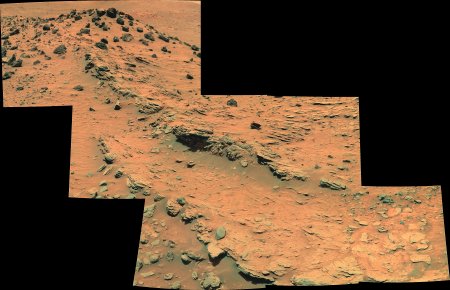
And the Gusev flats with a part of Husband Hill on Sol 1159.
All resolutions on : http://astrosurf.com/merimages/Images_de_spirit-2007.html
Posted by: dilo Apr 9 2007, 05:54 PM
Ant, you made an excellent work, as usual. I love in particular the "light evolution" couple of stitches...
About the Gusev panorama reported also by jvandriel in B/W, I have impression that we see very old Spirit tracks close to the center of image... am I right? 
Posted by: Tesheiner Apr 10 2007, 08:07 AM
Good catch, Dilo!
If those are rover tracks they might be from sols 740-743, when Spirit was on the final leg before touching HP. BTW, this mosaic was named "Tars Tarkas", another character from Edgar Rice Burroughs' "Barsoom" series.
Posted by: Tesheiner Apr 11 2007, 09:07 AM
There was another move on sol 1162 and it looks like Spirit is taking its time at the edge of HP.
I thought they would drive the rover northwards to the same point as sol 1148 to get on top of HP again.
From: http://marsrovers.jpl.nasa.gov/mission/status_spiritAll.html#sol1152
But no. Spirit is now placed not too far from the previous site (sol 1160), right behind the rock target "Elizabeth Mahon" probably to do an IDD session on it (see the http://nasa.exploratorium.edu/mars/spirit/forward_hazcam/2007-04-10/2F229523016EFFAS%23%23P1214R0M1.JPG). Here is a navcam mosaic taken on sol 1160 with the rover locations on sols 1153 and 1162.

|
Posted by: akuo Apr 11 2007, 11:43 AM
One might think that the rover drivers have no idea at all where they are going.
Posted by: Floyd Apr 11 2007, 02:17 PM
They know exactly what they are doing. Remember they are trying to figure out the source of the sulfate saltsare they from evaporation or from volcanic venting of sulfur containing gasses. "http://qt.exploratorium.edu/mars/spirit/forward_hazcam/2007-04-10/2F229523016EFFAS%23%23P1214L0M1.JPG" may be what you would expect if volcanic gasses were venting and formed deposits. So they have to check it out. Also notice the apparent sulfate salts in the recent front wheel track. Some coral looking deposits may have been crushed to make the http://qt.exploratorium.edu/mars/spirit/pancam/2007-04-09/2P229432671EFFAS%23%23P2514R1M1.JPG (far lower right corner).
Floyd
Posted by: Tesheiner Apr 12 2007, 10:36 AM
From the latest status report:
After investigating Madeline English, the rover will head back north to one of several possible "on-ramps" for driving onto Home Plate.
Posted by: akuo Apr 12 2007, 11:36 AM
Well, that makes sense then.
I guess we can forget about ever getting very far from Home Plate.
Posted by: Tesheiner Apr 12 2007, 02:13 PM
I wouldn't say that.
My only conclusion is that we might see very weird/strange manouvers when making turns or trying to approach a science objective.
Posted by: Shaka Apr 12 2007, 06:59 PM
Yeah, Tesh, the fundamental uncertainty is how easily the stuck wheel will hang-up on embedded rocks, once we leave the sandy area and venture across the plate. Hopefully the wheel will ride over most of the time. It's 'finger-crossin' time'!
Posted by: Marz Apr 12 2007, 08:19 PM
Some interesting pancam shots of the homeplate layers:
http://qt.exploratorium.edu/mars/spirit/pancam/2007-04-12/2P229613264EFFAS%23%23P2445L4M1.JPG
The dark splotches embedded in the outcrop in the center of the image look like inclusions in the ash layers, yes? They don't look like bomb sags to my uneducated gaze, which I presume the science guys are still looking for more examples?
Posted by: Stu Apr 12 2007, 08:37 PM
Impressive layering...

|
Posted by: jvandriel Apr 15 2007, 03:14 PM
A nice view over Gusev Crater.
Taken with the L0 Navcam on Sol 1164.
jvandriel

|
Posted by: mhoward Apr 15 2007, 03:47 PM
http://flickr.com/photo_zoom.gne?id=460009698&size=l
http://flickr.com/photo_zoom.gne?id=460011051&context=photostream&size=l
Posted by: mhoward Apr 17 2007, 11:43 AM
Here's a view of where she was on sol 1153, as seen from sol 1141, based on the rover tracking data. Rover model by Doug Ellison.
http://www.flickr.com/photo_zoom.gne?id=462744321&size=l
Posted by: Ant103 Apr 17 2007, 07:59 PM
Very nice job Michael
I have a question : can I take some of these rocks to bring them back to home? 

|
Posted by: Ant103 Apr 18 2007, 11:09 AM
The same place in color and in stereo :
http://astrosurf.com/merimages/Spirit/Images_en_couleur/Sol1164-Rocks.JPG
http://astrosurf.com/merimages/Spirit/Images_en_couleur/Sol1164-Rocks_anaglyphe.JPG

|
Posted by: Stu Apr 18 2007, 02:43 PM
Old tracks..?

|
Posted by: jvandriel Apr 19 2007, 07:38 PM
Here is the 360 degree panoramic view
taken on Sol 1164 with the L0 Navcam.
jvandriel
|
|
Posted by: centsworth_II Apr 19 2007, 08:39 PM
Spirit's been back and forth so much it's starting to look like...

|
http://tti.tamu.edu/groups/cpd/resources/images/railroad_transportation.htm
Posted by: CosmicRocker Apr 20 2007, 06:10 AM
Would you mind putting some sol numbers on that map?
Posted by: climber Apr 20 2007, 10:49 AM
574.8 ................km/h...it's what the TGV did 2 weeks ago
Posted by: Phil Stooke Apr 21 2007, 09:13 PM
jvandriel's pan in polar form:

|
and the tracks in more detail:

|
Phil
Posted by: Marz Apr 24 2007, 08:26 PM
Sulfates... they're not just for breakfast anymore!
http://qt.exploratorium.edu/mars/spirit/pancam/2007-04-24/2P230680408EFFAT48P2358R1M1.JPG
Posted by: Stu Apr 25 2007, 05:10 PM
Strange... looks like the ground falls away here and sediments filled a hollow...?

|
Posted by: kungpostyle Apr 25 2007, 06:11 PM
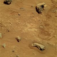
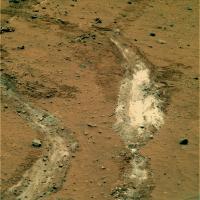
The new MI images show a nice brushing job on the newest target.
http://qt.exploratorium.edu/mars/spirit/micro_imager/2007-04-25/2M230768569EFFAT48P2956M2M1.JPG
Posted by: kungpostyle Apr 25 2007, 06:13 PM
Here is a good shot for context.
http://qt.exploratorium.edu/mars/spirit/forward_hazcam/2007-04-25/2F230769211EFFAT48P1110R0M1.JPG
Posted by: centsworth_II Apr 25 2007, 07:01 PM
http://qt.exploratorium.edu/mars/spirit/forward_hazcam/2007-04-25/2F230769211EFFAT48P1110R0M1.JPG
And the context is enhanced by seeing Husband Hill and El Dorado in the background.
Ahhh, nostalgia.
Posted by: Shaka Apr 25 2007, 08:00 PM
Nice! So then, does this unit represent the deepest so far examined of HP? Coarsely granular, but with only slightly-rounded, rather poorly-sorted clasts? Is this the logical product of local volcanic activity? How far away from the margin of HP does this extend? As far as Mitcheltree Ridge? Beyond? To McCool Hill?
Or is this something more recent than most of HP?
Science Marches On!
Posted by: CosmicRocker Apr 26 2007, 02:07 AM
Posted by: kungpostyle Apr 26 2007, 02:44 AM
Here is my version of the brushed area.
|
Posted by: jvandriel Apr 28 2007, 12:31 PM
Here is the Pancam L2 Panoramic view of Gusev Crater and Homeplate
taken between Sol 1169 and Sol 1174.
jvandriel

|
Posted by: Ant103 Apr 28 2007, 12:37 PM
Jvandriel : you are using Autostitch to make this pano. Is it right?
What are the stitching parameters you use to made it? I have some trouble to build the complete color pan ....
Posted by: jvandriel Apr 28 2007, 01:19 PM
Ant103,
Indeed, I always use Autostitch for stitching the Panorama's.
Here are the parameters for the Panorama,
Outputsize: 100%
Matching Options: 80% ( because the computer ran out of memory )
Theta: 0
Phi: 6.5
Psi: -2.5
Gain: 0.15
System Memory: -2
JPEG quality: 100%
Blanding bands: 2
Blanding: 5
The result is a Panorama of 20.3 MB.
jvandriel
Posted by: mhoward Apr 28 2007, 02:12 PM
That's a lovely stitch, jvandriel, and it's projected about right, too (compared to using the camera pointing data).
Posted by: jvandriel Apr 28 2007, 02:15 PM
Here is the coloured Pancam L2 view
taken on Sol 1175 and 1178.
jvandriel

|
Posted by: Ant103 Apr 28 2007, 02:46 PM
Jvandriel : it's stay in the same state... What are your RANSAC parameters? I can't understand that the software don't want to make a correct stitching (some of frames are correctly stitch but there are place where there are black area IN the panorama).
Posted by: jvandriel Apr 28 2007, 06:01 PM
Ant103,
the Ransac parameters for that Panorama are the standard
Parameters:
Alpha: 10
Beta 0.2
Max.Iterations: 500.
Sometimes, when Autostitch has difficulties to match some
of the images I change the following parameters to:
Matching Options.
Min.dim (pixels): 4400
Ransac Parameters.
Alpha: 2
Beta: 0,1
Max.Iterations: 4500.
Read also the Tech, General and Imagery Forum regarding Autostitch.
jvandriel
Posted by: alan Apr 28 2007, 07:40 PM
Autostitch didn't give me much trouble. I used the images MMB produced, left autostitch on the default stetings the first time through, spotted a couple of spots where it didn't stitch properly, changed the matching options to 100% and gain to 0.3 the second time. Then adjusted phi and psi to jvandriel's settings and the output to 100% on the third try. There are some small glitches, a small split on the right edge and some doubled rocks. I made some small adjustments, to color and contrast after autostitch was finished.

|
Posted by: jvandriel Apr 29 2007, 08:35 AM
There are 2 Dust Devils in the Sol 1169-1174 Panorama.
Look at the Top Row images.
The 6th image from Top Right.
jvandriel
Posted by: Oersted Apr 29 2007, 09:35 AM
Fabulous image of Home Base Alan. I think this could be the textbook picture of the place!
Posted by: Ant103 Apr 29 2007, 11:12 AM
I've finally "succeed" to make the pano :
http://astrosurf.com/merimages/Images_de_spirit-2007.html#Sol1169
(there are on the left "phantom rocks ")
So, here is a traditonal desktop made from the uper panorama :
http://astrosurf.com/merimages/Desktop/HomePlate-desktop.png
Posted by: Stu Apr 29 2007, 07:12 PM
Great pics Ant, as usual!
Love the variety of rocks visible to Spirit now...
|
Posted by: ollopa Apr 30 2007, 02:24 PM
Members might want to note that the Spirit team will have a paper on Home
Plate in the 04 May issue of Science.
Posted by: atomoid May 1 2007, 11:34 PM
fossilized profile of a humanoid soap-mummy at upper right of the http://mars.lyle.org/imagery/2M231027974EFFAT48P2976M2M1.JPG.html
Posted by: mhoward May 2 2007, 03:29 AM
So many nice views. Here are some model shots; the first one shows Spirit where she is right now (sol 1182), looking like she is ready to head back north to the Home Plate on-ramp (according to the latest Planetary Society update).
http://www.flickr.com/photo_zoom.gne?id=480809866&size=l http://www.flickr.com/photo_zoom.gne?id=480818020&context=photostream&size=l http://www.flickr.com/photo_zoom.gne?id=480809496&context=photostream&size=l
Posted by: Stu May 2 2007, 09:32 AM
Poor dusty little Spirit...

|
Posted by: atomoid May 2 2007, 08:48 PM
sorry to be a bit off-topic, but where did you find the MER model?
im looking for something like this to tinker with and have so far come up empty handed.
i purused through the tech&imagery threads but didnt see anything..
Posted by: mhoward May 2 2007, 08:56 PM
Check out the http://www.unmannedspaceflight.com/index.php?showtopic=682&st=510 thread. Version 2.0 has a feature where you can move the model around in panoramas based on the rover tracking data. The rover model is courtesy of one Doug Ellison - never heard of the guy, but it's a nice model and it renders well in realtime.
Posted by: AlexBlackwell May 3 2007, 05:39 PM
The embargo won't be lifted for a few more hours, but note that the May 4, 2007, issue of Science will have a http://www.sciencemag.org/content/vol316/issue5825/twis.dtl#316/5825/657n ("Pyroclastic Activity at Home Plate in Gusev Crater, Mars") by Squyres et al.
Posted by: AlexBlackwell May 3 2007, 07:53 PM
See the related press release:
http://www.jpl.nasa.gov/news/news.cfm?release=2007-051
NASA/JPL
May 3, 2007
Posted by: CosmicRocker May 3 2007, 09:01 PM
That Science paper This is the one we've been waiting for.
http://news.nationalgeographic.com/news/2007/05/070503-mars-volcano.html has a short blurb with a few comments from Steve Squyres and Larry Crumpler.
Posted by: AlexBlackwell May 3 2007, 09:07 PM
If you have access to Science, the http://www.sciencemag.org/cgi/content/abstract/316/5825/738 is available. Even if you don't, I believe the http://www.sciencemag.org/cgi/content/full/316/5825/738/DC1 is open access.
Posted by: Ant103 May 4 2007, 08:03 AM
|
|
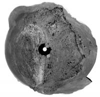
And here is a colorized micro-imagery of this RAT
http://astrosurf.com/merimages/Spirit/Inclassables/RATmosaic_couleur-sol1176.jpg
(colors are come from http://astrosurf.com/merimages/Spirit/Inclassables/2P230767463ESFAT48P2590-coul.JPG
)
Posted by: Stu May 5 2007, 10:18 AM
New details on Homeplate...

|
Posted by: Stu May 5 2007, 10:53 PM
... and a beautifully-detailed close-up... but look how dusty our poor gal is...

|
Posted by: djellison May 6 2007, 09:08 AM

http://pancam.astro.cornell.edu/pancam_instrument/1174A_BallPark.html
Not bad
Doug
Posted by: monitorlizard May 6 2007, 09:56 AM
"but look how dusty our poor gal is"
You could take Spirit to a Martian car wash, but water is $1 million a gallon, so you might want to wash her with a pipette.
Posted by: Stu May 6 2007, 10:39 AM
Yeah, what with those water import costs and lack of passing traffic you might not ever get rich working in a martian car wash... but let me tell you, it's better than digging a ditch...
Posted by: jvandriel May 6 2007, 12:08 PM
Spirit looking back on Sol 1184.
Taken with the L0 Navcam.
jvandriel

|
Posted by: jvandriel May 6 2007, 12:13 PM
and a Pancam L7 view of the wheeltracks.
Taken on Sol 1184.
jvandriel
|
Posted by: kungpostyle May 7 2007, 07:47 PM
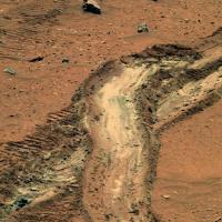
Looks like they're checking out the patch of light colored soil.
Interesting that the new wheel trench only inches away didn't uncover much bright soil at all.
http://qt.exploratorium.edu/mars/spirit/forward_hazcam/2007-05-06/2F231745685EFFATAZP1154R0M1.JPG
Posted by: Sunspot May 8 2007, 10:16 AM
Interesting image here:
http://qt.exploratorium.edu/mars/spirit/pancam/2007-05-07/2P231747976EFFATAZP2363R1M1.JPG
Look at all the different alignments of the layered rock.
Posted by: Stu May 8 2007, 10:51 AM
Lovely view...

|
Posted by: climber May 9 2007, 09:22 AM
Amizing, Stu, how a "familiar" place can look like an alien world...
Just beautiful
Posted by: AlexBlackwell May 9 2007, 05:43 PM
http://www.jpl.nasa.gov/news/news.cfm?release=2007-051
NASA/JPL
May 3, 2007
http://www.news.cornell.edu/stories/May07/squyres.pyroclastic.html
By Lauren Gold
Cornell Chronicle Online
May 8, 2007
Posted by: kenny May 9 2007, 07:57 PM
Now this is pretty bizarre ... the Mars Daily news site has a new Spirit update in usual JPL Sol-by-sol style for May 8, covering Sols 1179-1185, whereas the last Spirit update on the JPL site is dated April 13 covering Sols 1159-1163. Mars Daily usually just re-posts the material which has already appeared on the JPL site.
http://www.marsdaily.com/reports/Spirit_Examined_Light___Colored_Material_Near_Home_Plate_999.html
Kenny
Posted by: Floyd May 9 2007, 10:43 PM
I've noticed that the Mars Rover site (http://marsrovers.jpl.nasa.gov/mission/status.html) does not always have the same updates as the MER site (http://www.jpl.nasa.gov/missions/mer/daily.cfm). By this I mean that an update may be only at one site--they are always the same text if present at both sites. If you really want to see the update, check both sites.
Posted by: fredk May 10 2007, 04:09 PM
Speaking of the new Spirit updates, in http://marsrovers.jpl.nasa.gov/mission/status_spiritAll.html#sol1172 they wrote:
Posted by: Stu May 10 2007, 04:47 PM
More of the white stuff...

|
Posted by: kungpostyle May 10 2007, 06:47 PM
I think this is the area they are calling landslide.

|
Posted by: Gray May 10 2007, 06:49 PM
Ahh, you beat me to it.
I was about to suggest the same area.
Posted by: fredk May 11 2007, 12:13 AM
Sounds reasonable. I believe this is the same "landslide" area from the hirise image:
|
Posted by: fredk May 11 2007, 12:26 AM
A nice view of the "landslide" from sol 813, under low illumination angle. You can identify features with the orbital view I posted above.
|
Posted by: Gray May 11 2007, 01:54 PM
Hmm, if that truly is a landslide, I wonder what might have triggered it. On Earth there are a variety of processes that trigger landslides: earthquakes,very rapid rates sediment accumulation, heavy rains, removing the toe of a slope causing it to be unstable... water is often involved but not always.
Posted by: djellison May 11 2007, 02:40 PM
If you've got deposition for long enough, at some point, perhaps helped by a gust of wind - there will be that one bit of sand that just tips the balance and off you go
Doug
Posted by: fredk May 11 2007, 03:55 PM
Nearby impact would be another idea.
Posted by: RobertEB May 15 2007, 01:29 PM
http://marsrovers.jpl.nasa.gov/gallery/all/2/p/1192/2P232203123EFFATAZP2364R7M1.JPG
Check out that cap rock. Looks like very fine volcanic layering.
(EDITED : Bad practice to put a full res image into a thread - post a link instead)
Posted by: Tesheiner May 15 2007, 03:43 PM
> (EDITED : Bad practice to put a full res image into a thread - post a link instead)
In the specific case of the images from the MER website I would post the respective thumbnail as plain image linked to the full res picture. The thumbnail is only 1KB.
http://marsrovers.jpl.nasa.gov/gallery/all/2/p/1192/2P232203123EFFATAZP2364R7M1.JPG
Posted by: RobertEB May 15 2007, 03:49 PM
Check out that cap rock. Looks like very fine volcanic layering.
(EDITED : Bad practice to put a full res image into a thread - post a link instead)
Sorry
Posted by: jvandriel May 15 2007, 06:50 PM
Here is the 360 degree panoramic view taken on Sol 1187
with the L0 Navcam.
jvandriel
|
|
Posted by: Phil Stooke May 16 2007, 02:00 AM
And jvandriel's latest pan in polar format...
Phil
|
Posted by: fredk May 16 2007, 04:45 PM
|
Posted by: Analyst May 21 2007, 06:23 AM
Is Spirit even moving? I mean, they are at this side of home plate forever now. The sun won't be much higher in the sky and the wheel won't get better. Have they made a significant discovery or are there problems?
Analyst
Posted by: kenny May 21 2007, 07:39 AM
Yes, we're all wondering... week after week and it goes nowhere, Give us a clue?
Posted by: centsworth_II May 21 2007, 02:44 PM
I don't know if that's what they're doing, but
remember that an APXS and Mossbauer set
of observations can take two to three days.
Posted by: Tesheiner May 21 2007, 03:30 PM
Last move was yestersol (1201) and based on the imaging sequence names for that sol, and on the fhaz too, it looks like Spirit made http://nasa.exploratorium.edu/mars/spirit/navcam/2007-05-20/2N232989136EFFATCXP1902R0M1.JPG.
01201::p1154::02::2::0::0::2::0::4::front_hazcam_idd_unstow_doc_pri15
01201::p1201::22::2::0::0::2::0::4::front_haz_penultimate_1_bpp_pri_17
01201::p1212::07::2::0::0::2::0::4::front_haz_ultimate_2_bpp_pri15
01201::p1293::00::2::0::0::2::0::4::front_hazcam_scuff_doc_3bpp_pri71
01201::p1293::00::2::0::0::2::0::4::front_hazcam_scuff_doc_3bpp_pri71
01201::p1293::00::2::0::0::2::0::4::front_hazcam_scuff_doc_3bpp_pri71
01201::p1293::00::2::0::0::2::0::4::front_hazcam_scuff_doc_3bpp_pri71
01201::p1293::00::2::0::0::2::0::4::front_hazcam_scuff_doc_3bpp_pri71
01201::p1293::00::2::0::0::2::0::4::front_hazcam_scuff_doc_3bpp_pri71
01201::p1293::00::2::0::0::2::0::4::front_hazcam_scuff_doc_3bpp_pri71
01201::p1293::00::2::0::0::2::0::4::front_hazcam_scuff_doc_3bpp_pri71
01201::p1293::00::2::0::0::2::0::4::front_hazcam_scuff_doc_3bpp_pri71
01201::p1293::00::2::0::0::2::0::4::front_hazcam_scuff_doc_3bpp_pri71
01201::p1301::09::2::0::0::2::0::4::penultimate_rear_hazcam_pri_17
01201::p1312::09::2::0::0::2::0::4::ultimate_rear_hazcam_2_bpp_pri15
01201::p1562::10::1::0::0::0::0::1::dust_devil_watch_az_275
01201::p1902::03::4::0::0::4::0::8::navcam_1x2_scuff_RVRAZ0_halfbpp
01201::p1903::03::4::0::0::4::0::8::navcam_1x2_scuff_RVRAZ0_LOCO
Posted by: Stu May 21 2007, 11:15 PM
Spirit might not be moving very much, but the scenery here is fascinating...
|
Posted by: CosmicRocker May 22 2007, 03:51 AM
Posted by: nprev May 22 2007, 05:19 AM
It is indeed. I don't think we've seen a greater diversity of both rock and soil types at any other location on Mars before...the history of this region must be somethng to behold, if we can decipher it. Steve's probably close to losin' it right now!
Posted by: OWW May 22 2007, 08:42 AM
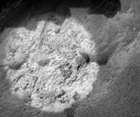
The APXS reportedly showed 90% non-crystalline silica.
Yep:
Mars Rover Spirit Unearths Surprise Evidence of Wetter Past
http://www.jpl.nasa.gov/news/news.cfm?release=2007-061
Posted by: Tesheiner May 22 2007, 09:28 AM
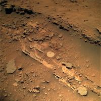
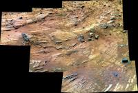
Here is a 1x2 navcam mosaic of "Gertrude Weise" and the scuffed area, taken on sol 1201. A 4x3 pancam mosaic (L257R2) of that same area was shot today (sol 1202), but hasn't hit the ground yet.
|
Now I'm wondering if Spirit will return back again to GW for further investigation of the new trench or will she finally make honor to the name of this thread.
My 2c on the former.
Posted by: Stu May 22 2007, 11:06 AM
Some more trench views...
|
|
Posted by: Tesheiner May 22 2007, 12:37 PM
Nice colorization, Stu.
The second one is part of the pancam mosaic I referred on my previous post. Here is what has been downlinked up to now (9 out of 12 pointings), in B&W.
|
Posted by: alan May 23 2007, 12:14 AM
Color mosaic from 1202, couple more pointings yet to be downloaded.
|
Posted by: Tesheiner May 23 2007, 02:09 PM
Well, it looks like I lost http://www.unmannedspaceflight.com/index.php?s=&showtopic=3868&view=findpost&p=90561.
Spirit is back again on the edge of HP.
http://nasa.exploratorium.edu/mars/spirit/rear_hazcam/2007-05-23/2R233166104EFFATEEP1314R0M1.JPG
(rhazcam, sol 1203)
Posted by: BrianL May 24 2007, 11:58 AM
Spirit is back again on the edge of HP.
Umm... can I apply my sol 1205 guess for the "entering Victoria crater" pool to the "return to top of Home Plate" pool?
Brian
Posted by: jvandriel May 24 2007, 07:07 PM
Spirit looking around on Sol 1192.
Taken with the R7 Pancam.
jvandriel
|
|
Posted by: CosmicRocker May 25 2007, 04:40 AM
BrianL: I don't see why not...and by doing so, it appears that you win 2 cents from Tesheiner.
Posted by: Stu May 26 2007, 05:03 PM
Some luvverly fine layering...
|
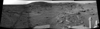
Posted by: jvandriel May 26 2007, 08:11 PM
Here is the 360 degree panoramic view taken with the
L0 Navcam on Sol 1203 and Sol 1205.
jvandriel
|
|
Posted by: Phil Stooke May 26 2007, 08:30 PM
... and in polar format...
Phil
|
Posted by: jvandriel May 27 2007, 12:13 PM
Here is the L7 panoramic view taken on Sol 1203.
jvandriel

|
Posted by: jvandriel May 27 2007, 02:36 PM
The Mi mosaic after brushing on Sol 1205.
jvandriel
|
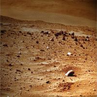
Posted by: Stu May 27 2007, 05:26 PM
Love all the weird 'sculptures' here...
|
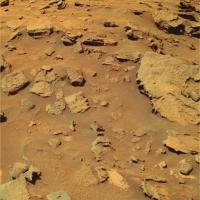
Posted by: alan May 27 2007, 06:20 PM
Lots of layering. I wonder if they will stick around for awhile to determine if the composition changes between the upper and lower layers.
|
Posted by: Floyd May 27 2007, 07:57 PM
Great image. Fantastic geology. Don't the rover drivers have any respect, they drive over most exquisite sculptures. Actually, the layered material is quite strong as the furthest track crossed a layered rock with no apparent damage.
Posted by: dvandorn May 27 2007, 08:36 PM
I don't know how effectively Spirit can do that with her RAT worn out. Brushing is good, but it doesn't remove weathering rinds.
Might be worth a try, though.
-the other Doug
Posted by: nprev May 28 2007, 02:28 PM
Check out the tabular rock to the left of center here. Looks like Spirit knocked off a top layer of the rock (visible on the left side of same), and there was a smear of dark soil in between them (still visible on top of the main rock). VERY interesting...
Posted by: belleraphon1 May 30 2007, 01:47 AM
jvandriel
I wander through these threads with a sense of mystic wonder. How beautiful and evocative all this is.
Can imagine myself standing there, looking off to the horizon. The thin, stingingly cold air, whistles over these desert sands, a hollow, lonely song..................
What you folks at UMSF have done, with your expertise and love, is gold.
Craig
Posted by: Oersted May 30 2007, 02:51 PM
Let's also thank the good people at JPL who are managing our mission...
Posted by: belleraphon1 May 30 2007, 08:51 PM
OH.......that goes without saying. To all those who snip the hardware, plan the trajectories, pour their lives into these missions and make them real.... thank you!!!!!!
A humbled Craig
Posted by: Phil Stooke May 30 2007, 10:45 PM
Spirit moved south today, driving along the rocky edge of Home Plate.
Phil
Posted by: mhoward May 31 2007, 12:18 AM
Spirit's approximate placement on sol 1210 (probably off by a little bit)
http://flickr.com/photo_zoom.gne?id=522363003&size=l
Posted by: monitorlizard May 31 2007, 02:52 AM
Alan, that false-color mosaic from May 27 is flat-out georgous!
All those layers--the pages of a book I would very much like to read.
Posted by: Tesheiner May 31 2007, 04:19 PM
A polar projection made with the http://nasa.exploratorium.edu/mars/spirit/navcam/2007-05-31/ (from sol 1210).
|
I'm wondering if they are planning to study this whole edge of HP in small steps like the last one or will just study this corner and then really enter the bowl.
Probably we will have to wait for some fresh news on the next TPS MER Update (should be http://www.planetary.org/explore/topics/mars_exploration_rovers/ today or tomorrow).
Posted by: Tesheiner Jun 1 2007, 10:23 AM
Here is what's said on the http://www.planetary.org/news/2007/0531_Mars_Exploration_Rovers_Update_Spirit.html:
"We're very slowly climbing up onto Home Plate, and along the way doing remote sensing and IDD measurements of the several different layers that make up the eastern part of this plateau," he added. "We're going to cut across caddy-corner the topographic contours rather than climbing straight up." Depending on what Spirit finds, the rover should be up on top of Home Plate sometime next week or the week after that.
From there, it all depends really on what Spirit sees. "The general desire is to stay on top of Home Plate, but follow the outcrop exposures around to the portion that everybody really wants to get to -- the far end or southwestern portion of Home Plate,"
Posted by: jvandriel Jun 2 2007, 01:39 PM
and here is the 360 degree panoramic view from Sol 1210.
Taken with the L0 Navcam.
jvandriel
|
|
Posted by: CosmicRocker Jun 3 2007, 05:09 AM
That's a beautiful 360 view, jvandriel.
The recent PS update said, "But then we got the hint that this was going to be something a little bit different because the Mini-TES saw a high silica signature that had also been seen in other rocks nearby." Might it be that high concentrations of silica were observed in this area of HP, and that is why they stopped to take a look?
"The general desire is to stay on top of Home Plate, but follow the outcrop exposures around to the portion that everybody really wants to get to -- the far end or southwestern portion of Home Plate," said Yen. That was the comment I found most interesting. That end of HP seems to be overlapped by some younger layers. I can't wait to see them.
Posted by: dilo Jun 3 2007, 07:01 AM
Polar and Vertical from JV panorama:
|

|
(sorry for insistence but, please, remind to use always Right-cam Navigation images, which are less noisy and slightly more sharper, also in this case!).
Posted by: Ant103 Jun 3 2007, 10:50 PM
Hello
A few days without posting a picture because a lot of work at school...
So, the Sol 1192 panorama, taken with R2 & R7 filters, in the very late afternoon (no hard shadow, is due to dust who decrease sun lighting, or the sun is under horizon?) :
http://astrosurf.com/merimages/Images_de_spirit-2007.html#Sol1192
And a desktop picture :
http://astrosurf.com/merimages/Desktop/FinDuSol1192-desktop.png
It's so hard to update himself about rovers status
Posted by: Ant103 Jun 4 2007, 02:37 PM
I've found time to re-catch... time
So, here is two mosaic.
One, taken on Sol 1202, who show Spirit deep tracks :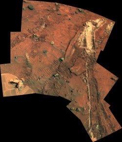
An other, on Sol 1206, show Home Plate's complex layering :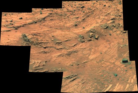
All resolution here :
http://astrosurf.com/merimages/Images_de_spirit-2007.html#Sol1192
Posted by: jvandriel Jun 6 2007, 07:28 PM
Here is the 360 degree Panoramic view taken with the R0 ( Dilo )
Navcam on Sol 1215 with the Dust Devil in the background.
jvandriel
|
|
Posted by: dicktone Jun 9 2007, 03:42 AM
http://astrosurf.com/merimages/Desktop/FinDuSol1192-desktop.png
I'm a long-time lurker, and this is my first post.
This image captures perfectly the beautiful synthesis of science and wonder that Spirit and Opportunity have bequeathed to us. I made it my desktop background on my work computer, and played the 'Guess where this is?' game with my colleagues. Their astonishment and awe when they found it was Mars (and not Nevada or Arizona) was wonderful to behold.
Thanks to all at UMSF for bringing a little bit of magic into the world.
Posted by: nprev Jun 9 2007, 03:51 AM
Beautiful as usual, Ant; first thing Monday morning that's going up as my work desktop, too. Thanks, and HAIL ANTS!
Posted by: sattrackpro Jun 9 2007, 09:23 AM
It's nice to see new folks joining in the fun here - particularly someone that has come often but never posted.
Your experience has been mine as well... many have asked me what state various Mars photos were taken in, and I've much enjoyed the various reactions when I tell them the photo is a composite of many that were recently taken on Mars - and point them to this website. I know several that are still 'lurkers.'
Posted by: jvandriel Jun 9 2007, 11:30 AM
The last images are down and here is the complete Panorama
taken on Sol 1205-1206-1208 and 1209 with the L2 Pancam.
jvandriel
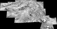
|
Posted by: Stu Jun 10 2007, 08:26 PM
Interesting rock today...
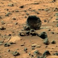
|
Posted by: Floyd Jun 10 2007, 09:07 PM
From the most recent http://qt.exploratorium.edu/mars/spirit/navcam/2007-06-10/2N234768251EFFATI4P0165L0M1.JPGit looks like Spirit has moved off the edge of home plate and is about to explore some more exposed silica?
Posted by: mhoward Jun 10 2007, 10:27 PM
It looks like you are http://flickr.com/photos/marscat/539510355/. Must be a change of plan.
Posted by: CosmicRocker Jun 11 2007, 04:33 AM
That was a surprise, wasn't it? Thanks for the metadata update, Mike. I just can't believe how smoothly I am spinning around in these MMB panoramas. I thought I saw several interesting targets in the pancams they imaged. Who would have expected them to return to silica valley.
Posted by: Tesheiner Jun 11 2007, 08:38 AM
I was surprised too when I saw the latest hazcam images.
Let's see if the next status update give us any hint about this decision.
Powered by Invision Power Board (http://www.invisionboard.com)
© Invision Power Services (http://www.invisionpower.com)