Journey to Mt Sharp - Part 2: Darwin to Cooperstown, Sol 402 [Sep23,'13] to Sol452 [Nov14,'13] NB: Warm Reset |

  |
Journey to Mt Sharp - Part 2: Darwin to Cooperstown, Sol 402 [Sep23,'13] to Sol452 [Nov14,'13] NB: Warm Reset |
 Sep 23 2013, 01:55 PM Sep 23 2013, 01:55 PM
Post
#1
|
||
|
Solar System Cartographer  Group: Members Posts: 10149 Joined: 5-April 05 From: Canada Member No.: 227 |
We're leaving Waypoint 1 so a new topic may be useful.
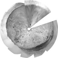
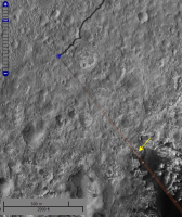
This is a circular view of where we are now, sol 402. Phil
-------------------- ... because the Solar System ain't gonna map itself.
Also to be found posting similar content on https://mastodon.social/@PhilStooke NOTE: everything created by me which I post on UMSF is considered to be in the public domain (NOT CC, public domain) |
|
 |
 
|
|
|
Sep 24 2013, 09:13 AM
Post
#2
|
|
|
Senior Member Group: Members Posts: 2346 Joined: 7-December 12 Member No.: 6780 |
Sol 402 Mastcam Left 5-frame autostitch:

|
|
|
|
|
Sep 24 2013, 12:28 PM
Post
#3
|
|
 Senior Member Group: Members Posts: 1465 Joined: 9-February 04 From: Columbus OH USA Member No.: 13 |
Based on the latest NAVCAM thumbnails, looks like a long drive happened on sol 403, maybe 4 hours duration--didn't make the cut for the 403 sunset SPICE update though, so no data yet.
-------------------- |
|
|
|
|
Sep 24 2013, 01:33 PM
Post
#4
|
||
|
Solar System Cartographer Group: Members Posts: 10149 Joined: 5-April 05 From: Canada Member No.: 227 |
This is a start on a circular pan from 403, current navcams only.
Phil
-------------------- ... because the Solar System ain't gonna map itself.
Also to be found posting similar content on https://mastodon.social/@PhilStooke NOTE: everything created by me which I post on UMSF is considered to be in the public domain (NOT CC, public domain) |
|
|
|
|
|
|
Sep 24 2013, 05:06 PM
Post
#5
|
|
 Junior Member Group: Members Posts: 60 Joined: 22-October 04 Member No.: 102 |
QUOTE (jmknapp @ Sep 24 2013, 12:28 PM)  Based on the latest NAVCAM thumbnails, looks like a long drive happened on sol 403, maybe 4 hours duration--didn't make the cut for the 403 sunset SPICE update though, so no data yet. So if it was indeed a 4 hour drive, assuming no stops /minimal turns the maximum distance she could have traveled would be 576m. Extrapolated as 4cm per second x 4 hrs = 4 x 60 x 60 x 4cm / 100 = 576m Doubtful it would be that long but still quite the trek  John |
|
|
|
|
Sep 24 2013, 06:24 PM
Post
#6
|
|
 Senior Member Group: Members Posts: 4246 Joined: 17-January 05 Member No.: 152 |
70 m as the crow flies, according to Phil.
|
|
|
|
|
Sep 24 2013, 06:48 PM
Post
#7
|
|
|
Founder Group: Chairman Posts: 14431 Joined: 8-February 04 Member No.: 1 |
QUOTE (Marslauncher @ Sep 24 2013, 10:06 AM) So if it was indeed a 4 hour drive, assuming no stops /minimal turns the maximum distance she could have traveled would be 576m. The rover DOES stop and turn. Autonav and Visidom mean the maximum distance per hour is typically 40m. |
|
|
|
|
Sep 24 2013, 09:22 PM
Post
#8
|
|
|
Senior Member Group: Members Posts: 2346 Joined: 7-December 12 Member No.: 6780 |
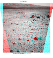
Some Sol 403 Navcam B stereo, as x-eyed and as anaglyph:
|
|
|
|
|
Sep 25 2013, 12:10 AM
Post
#9
|
|
|
Senior Member Group: Members Posts: 1465 Joined: 9-February 04 From: Columbus OH USA Member No.: 13 |
The recent drive was close to 4 hours but only a modest 70 meters--so a different kind of stop-and-go pattern I guess.
-------------------- |
|
|
|
|
Sep 25 2013, 09:58 AM
Post
#10
|
|
 Senior Member Group: Members Posts: 2425 Joined: 30-January 13 From: Penang, Malaysia. Member No.: 6853 |
Sol 404 : Another drive, the Hazcam time-stamps indicate a duration of around 143 minutes, with the available thumbnail images indicating we are continuing in a general South West direction.
|
|
|
|
|
Sep 25 2013, 11:56 AM
Post
#11
|
|
|
Senior Member Group: Members Posts: 1465 Joined: 9-February 04 From: Columbus OH USA Member No.: 13 |
QUOTE (PaulH51 @ Sep 25 2013, 05:58 AM) Sol 404 : Another drive, the Hazcam time-stamps indicate a duration of around 143 minutes, with the available thumbnail images indicating we are continuing in a general South West direction. Indeed, 64 meters southwest. -------------------- |
|
|
|
|
Sep 25 2013, 12:44 PM
Post
#12
|
|
|
Senior Member Group: Members Posts: 2346 Joined: 7-December 12 Member No.: 6780 |
|
|
|
|
|
Sep 25 2013, 01:36 PM
Post
#13
|
||
|
Solar System Cartographer Group: Members Posts: 10149 Joined: 5-April 05 From: Canada Member No.: 227 |
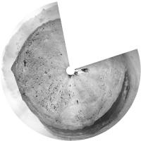
This is the sol 404 location in circular form.
Phil
-------------------- ... because the Solar System ain't gonna map itself.
Also to be found posting similar content on https://mastodon.social/@PhilStooke NOTE: everything created by me which I post on UMSF is considered to be in the public domain (NOT CC, public domain) |
|
|
|
|
|
|
Sep 25 2013, 09:25 PM
Post
#14
|
||
|
Member Group: Members Posts: 866 Joined: 15-March 05 From: Santa Cruz, CA Member No.: 196 |
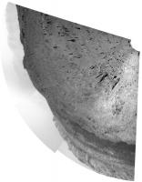
QUOTE (Gerald @ Sep 25 2013, 05:44 AM) A Sol 404 ChemCam "telescopic" image after some flat field correction, stretching, and masking: that's impressive detail for a kilometer away if ive pinpointed it correctly in Joes mapper.. as the little ridge at top left corresponds to the little crater bay at the edge of the black sea?
|
|
|
|
|
|
|
Sep 25 2013, 11:37 PM
Post
#15
|
|
 Member Group: Members Posts: 222 Joined: 7-August 12 From: Garberville, CA Member No.: 6500 |
Sol 402 thru 404 Navcam 270's...
I prefer to hold out for 360's (full 12 frame sets) before rendering, but when the trend is toward "9 frames down - then move on" as of lately, I'll just get the 270's up without further ado, as below: Sol 402: 2-D (NRB): .jpg) Anaglyph:  Sol 403: 2-D (NRB): .jpg) Anaglyph:  Sol 404: 2-D (NRB): .jpg) Anaglyph: 
-------------------- "We shall not cease from exploration, and the end of all our exploring will be to arrive where we started and know the place for the first time." -T.S. Eliot
|
|
|
|
|

|
Lo-Fi Version | Time is now: 23rd April 2024 - 11:45 AM |
|
RULES AND GUIDELINES Please read the Forum Rules and Guidelines before posting. IMAGE COPYRIGHT |
OPINIONS AND MODERATION Opinions expressed on UnmannedSpaceflight.com are those of the individual posters and do not necessarily reflect the opinions of UnmannedSpaceflight.com or The Planetary Society. The all-volunteer UnmannedSpaceflight.com moderation team is wholly independent of The Planetary Society. The Planetary Society has no influence over decisions made by the UnmannedSpaceflight.com moderators. |
SUPPORT THE FORUM Unmannedspaceflight.com is funded by the Planetary Society. Please consider supporting our work and many other projects by donating to the Society or becoming a member. |
|