Spirit Route Map, Small and Large Scales |

  |
Spirit Route Map, Small and Large Scales |
 Feb 14 2009, 07:01 AM Feb 14 2009, 07:01 AM
Post
#631
|
||
 Senior Member  Group: Members Posts: 2228 Joined: 1-December 04 From: Marble Falls, Texas, USA Member No.: 116 |
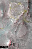
Here you go, imipak. It's all yours. Thank you, Eduardo, for graciously allowing me to lift information from your superb route maps and drop that onto the anaglyph I made from HiRise imagery provided by NASA/JPL/UA people. I expanded the area of this map so it would display the Von Braun and Goddard goals in context, and I added an arrow pointing to the southern exit ramp that fredk recently reminded us of.
-------------------- ...Tom
I'm not a Space Fan, I'm a Space Exploration Enthusiast. |
|
 |
 
|
|
| Guest_Oersted_* |
Feb 14 2009, 11:56 AM
Post
#632
|
|
Guests |
I know this must be asking for far too much, but would it be possible to "drape" the overlay information onto the height map, so the route and all the names lie "on the ground"? - I think I've seen that with other maps, and it is stunning.
|
|
|
|
|
Feb 14 2009, 03:42 PM
Post
#633
|
|
|
Senior Member Group: Members Posts: 2228 Joined: 1-December 04 From: Marble Falls, Texas, USA Member No.: 116 |
Oersted: If I am understanding your request correctly, you are asking for a map in which the route lines and labels are also anaglyphs, so everything lies at the correct depth on the map. That would essentially require me to redraw Eduardo's route lines and labels to match the locations on the second HiRise image comprising the anaglyph. I absolutely agree with you that that would make a superior map where the lines and labels are not sometimes floating above or below the perceived surface. I'm afraid however, that I do not have the time to do that. Sorry.

-------------------- ...Tom
I'm not a Space Fan, I'm a Space Exploration Enthusiast. |
|
|
|
| Guest_Oersted_* |
Feb 14 2009, 04:04 PM
Post
#634
|
|
Guests |
Oh, no way I would want anybody to do that manually. I was just wondering out aloud, whether it would be possible automatically to transfer the height info of the relief map to the lines and names. Probably not...
|
|
|
|
|
Feb 14 2009, 04:13 PM
Post
#635
|
|
 Member Group: Members Posts: 646 Joined: 23-December 05 From: Forest of Dean Member No.: 617 |
Magnificent, CR, thanks (and to Eduardo for the mapping of course!) There'll be another "show and tell" session for my lucky colleagues in the office next week. FWIW, personally I like the look of the labels as a floating upper layer.
-------------------- --
Viva software libre! |
|
|
|
|
Feb 16 2009, 07:35 PM
Post
#636
|
|
|
Member Group: Members Posts: 713 Joined: 30-March 05 Member No.: 223 |
QUOTE (imipak @ Feb 14 2009, 05:13 PM)  FWIW, personally I like the look of the labels as a floating upper layer. Ditto, So do I ... sometimes less features is actually more 
|
|
|
|
|
Feb 17 2009, 09:12 AM
Post
#637
|
||
|
Senior Member Group: Moderator Posts: 4279 Joined: 19-April 05 From: .br at .es Member No.: 253 |
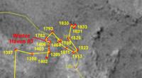
The latest moves were so small that it doesn't deserve an update of the route map, however I thought it was time to double-check the "plots" on the map since Spirit left the winter haven, comparing the navcam mosaics in polar projection with the HiRISE picture. The result is that those moves were overestimated and Spirit's current position is a few meters to the left of where it was previously pointed.
And here's a GE layer too:  Route_Map_Sol1820.kml ( 5.35K )
Number of downloads: 515
Route_Map_Sol1820.kml ( 5.35K )
Number of downloads: 515 |
|
|
|
|
|
|
Feb 24 2009, 05:02 PM
Post
#638
|
||
|
Senior Member Group: Moderator Posts: 4279 Joined: 19-April 05 From: .br at .es Member No.: 253 |
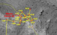
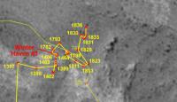
Here's another map update, corresponding to sol 1829, slightly adjusted respect to the one posted here. When registering the navcam mosaic in polar projection to the map background I found that the initial estimate was off by around 20%.
Route_Map_Sol1829n.kml ( 6.11K )
Number of downloads: 445 |
|
|
|
|
|
|
Feb 26 2009, 10:13 AM
Post
#639
|
|
|
Senior Member Group: Moderator Posts: 4279 Joined: 19-April 05 From: .br at .es Member No.: 253 |
|
|
|
|
|
Feb 27 2009, 09:09 PM
Post
#640
|
||
|
Senior Member Group: Moderator Posts: 4279 Joined: 19-April 05 From: .br at .es Member No.: 253 |
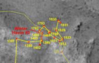
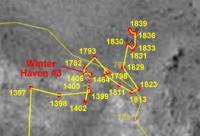
Yet another update: sol 1831. Dodging some rocks in the search of a path NE of Home Plate.
Route_Map_Sol1831.kml ( 7.45K )
Number of downloads: 440 |
|
|
|
|
|
|
Mar 1 2009, 10:08 PM
Post
#641
|
|
|
Senior Member Group: Moderator Posts: 4279 Joined: 19-April 05 From: .br at .es Member No.: 253 |
|
|
|
|
|
Mar 4 2009, 02:04 PM
Post
#642
|
||
|
Senior Member Group: Moderator Posts: 4279 Joined: 19-April 05 From: .br at .es Member No.: 253 |
Here's a crop of the map including Spirit's current position (sol 1836).
Route_Map_Sol1836.kml ( 7.81K )
Number of downloads: 422 |
|
|
|
|
|
|
Mar 6 2009, 09:36 PM
Post
#643
|
|
|
Senior Member Group: Moderator Posts: 4279 Joined: 19-April 05 From: .br at .es Member No.: 253 |
|
|
|
|
|
Mar 22 2009, 10:33 AM
Post
#644
|
||
|
Senior Member Group: Moderator Posts: 4279 Joined: 19-April 05 From: .br at .es Member No.: 253 |
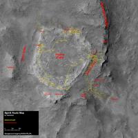
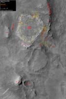
I think it's time to post the whole map again and make it a little bigger extending it to cover our planned destination: Von Braun and Goddard.
The route points are updated to the last drive, which happened during sol 1854.
|
|
|
|
|
|
|
Mar 22 2009, 11:58 AM
Post
#645
|
|
 The Poet Dude Group: Moderator Posts: 5551 Joined: 15-March 04 From: Kendal, Cumbria, UK Member No.: 60 |
Cripes, looking at the new map (thanks, Tesh) it's a long way!
 Good luck Spirit! -------------------- |
|
|
|
|

|
Lo-Fi Version | Time is now: 24th April 2024 - 11:17 AM |
|
RULES AND GUIDELINES Please read the Forum Rules and Guidelines before posting. IMAGE COPYRIGHT |
OPINIONS AND MODERATION Opinions expressed on UnmannedSpaceflight.com are those of the individual posters and do not necessarily reflect the opinions of UnmannedSpaceflight.com or The Planetary Society. The all-volunteer UnmannedSpaceflight.com moderation team is wholly independent of The Planetary Society. The Planetary Society has no influence over decisions made by the UnmannedSpaceflight.com moderators. |
SUPPORT THE FORUM Unmannedspaceflight.com is funded by the Planetary Society. Please consider supporting our work and many other projects by donating to the Society or becoming a member. |
|