MSL at Rocknest, First scoop samples - sols 57-101 |

  |
MSL at Rocknest, First scoop samples - sols 57-101 |
 Oct 29 2012, 12:36 AM Oct 29 2012, 12:36 AM
Post
#314
|
|
 Member  Group: Members Posts: 161 Joined: 12-August 12 From: Hillsborough, NJ Member No.: 6546 |
QUOTE (ngunn @ Oct 28 2012, 07:32 PM)  I went for the 'Large'. That is stupendous, and yes, the ends do join up. (If only it could be viewed that way . . .) They can. If the image is uploaded to http://www.360cities.net/ it will make it into a spherical panorama that connects. I like the Gigapan site the best, but if you have a panorama that that matches on both ends, 360cities is the way to go. Both sites are awesome and they can handle images in the gigs. And they don't even have to be compressed! -------------------- |
 |
 
|
|
Oct 29 2012, 12:52 AM
Post
#315
|
|
|
Solar System Cartographer Group: Members Posts: 10151 Joined: 5-April 05 From: Canada Member No.: 227 |
The little natural arch thing is on a rock called Zephyr, and it is being referred to as Stonehenge, in the recent Youtube video update. It is immediately below and to the left of Crestaurum on my recent little map.
Phil -------------------- ... because the Solar System ain't gonna map itself.
Also to be found posting similar content on https://mastodon.social/@PhilStooke Maps for download (free PD: https://upload.wikimedia.org/wikipedia/comm...Cartography.pdf NOTE: everything created by me which I post on UMSF is considered to be in the public domain (NOT CC, public domain) |
|
|
|
|
Oct 29 2012, 01:08 AM
Post
#316
|
|
 Member Group: Members Posts: 222 Joined: 7-August 12 From: Garberville, CA Member No.: 6500 |
Got it up to Gigapan, so the full 84,213 x 3,383px version is online here. Gotta admit, going full screen is pretty fun.
-------------------- "We shall not cease from exploration, and the end of all our exploring will be to arrive where we started and know the place for the first time." -T.S. Eliot
|
|
|
|
|
Oct 29 2012, 05:57 AM
Post
#317
|
||
 Senior Member Group: Admin Posts: 3108 Joined: 21-December 05 From: Canberra, Australia Member No.: 615 |
Brilliant pan Ed.
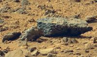
This entire area is amazing. Curiosity could spend her entire mission here. But distant horizons beckon  I do hope that they will take an opportunity to take a closer image of this rock group though. It keeps popping out everytime I look at images of this area. Interesting curved features in an area with so many angular rocks. Must say something different about this area.
I guess that everyone has something from this pan that they'd like to see. Onwards!! |
|
|
|
|
|
|
Oct 29 2012, 07:18 AM
Post
#318
|
|
|
Member Group: Members Posts: 282 Joined: 18-June 04 Member No.: 84 |
WOW...amazing pan Ed.
I really didn't think they would use the high resolution camera to make large pans of the surface like this. |
|
|
|
|
Oct 29 2012, 10:30 AM
Post
#319
|
|
 Newbie Group: Members Posts: 5 Joined: 9-October 12 Member No.: 6694 |
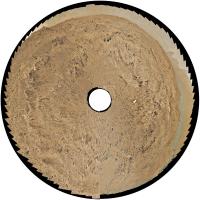
Does anyone know the name of the instrument shown here?
http://mars.jpl.nasa.gov/msl-raw-images/ms...1000C0_DXXX.jpg Edit: sorry, did want to reduce image size but didn't know how. |
|
|
|
|
Oct 29 2012, 11:37 AM
Post
#320
|
|
 Senior Member Group: Moderator Posts: 2262 Joined: 9-February 04 From: Melbourne - Oz Member No.: 16 |
That is the REMS UV sensor
From http://msl-scicorner.jpl.nasa.gov/Instruments/REMS/ QUOTE The UV sensor will be located on the rover deck and is composed of six photodiodes in the following ranges: 315-370 nm (UVA), 280-320 nm (UVB), 220-280 nm (UVC), 200-370 nm (total dose), 230-290 nm (UVD), and 300-350 nm (UVE), with an accuracy better than 8% of the full range for each channel, computed based on Mars radiation levels and minimum dust opacity. The photodiodes face the zenith direction and have a field of view of 60 degrees. The sensor will be placed on the rover deck without any dust protection. To mitigate dust degradation, a magnetic ring has been placed around each photodiode with the aim of maximizing their operational time. Nevertheless, to evaluate dust deposition degradation, images of the sensor will be recorded periodically. Comparison of these images with laboratory measurements will permit evaluation of the level of dust absorption.
-------------------- |
|
|
|
|
Oct 29 2012, 01:46 PM
Post
#321
|
||
|
Solar System Cartographer Group: Members Posts: 10151 Joined: 5-April 05 From: Canada Member No.: 227 |
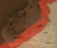
A stupendous pan from Edtruthan! Here I have made a circular version of it, obviously greatly reduced in size (My trusty ENIAC processor won't quite manage this at full resolution). The join at the ends is not quite exact here, still a little bit of duplication of rocks, but it's close. It shows the structure of Glenelg quite nicely.
Phil
-------------------- ... because the Solar System ain't gonna map itself.
Also to be found posting similar content on https://mastodon.social/@PhilStooke Maps for download (free PD: https://upload.wikimedia.org/wikipedia/comm...Cartography.pdf NOTE: everything created by me which I post on UMSF is considered to be in the public domain (NOT CC, public domain) |
|
|
|
|
|
|
Oct 29 2012, 02:57 PM
Post
#322
|
|||
 Member Group: Members Posts: 154 Joined: 19-September 12 Member No.: 6658 |
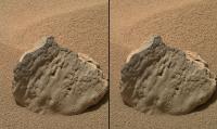
Really awesome Ed - thank you!
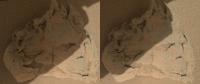
Some eye-crossing - sol 82:
[Edit]: Rock is named "Et-Then" and maybe the sides are switched in the anaglyph ... |
||
|
|
|
||
|
Oct 29 2012, 04:50 PM
Post
#323
|
|
 Member Group: Members Posts: 276 Joined: 11-December 07 From: Dar es Salaam, Tanzania Member No.: 3978 |
Awesome panorama Ed!

-------------------- |
|
|
|
|
Oct 29 2012, 05:05 PM
Post
#324
|
|||
 Senior Member Group: Members Posts: 4246 Joined: 17-January 05 Member No.: 152 |
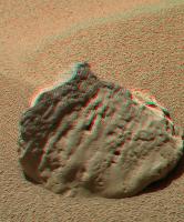
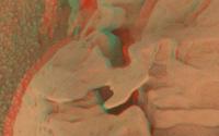
Mahli stereo showing some very delicate-looking structure:
|
||
|
|
|
||
|
Oct 29 2012, 05:16 PM
Post
#325
|
||
|
Member Group: Members Posts: 222 Joined: 7-August 12 From: Garberville, CA Member No.: 6500 |
In this brightened crop of your anaglyph FredK, it looks like this delicate little fan is actually attached at two points. Really interesting questions at play here...
-------------------- "We shall not cease from exploration, and the end of all our exploring will be to arrive where we started and know the place for the first time." -T.S. Eliot
|
|
|
|
|
|
|
Oct 29 2012, 05:30 PM
Post
#326
|
|
|
Junior Member Group: Members Posts: 26 Joined: 3-August 12 Member No.: 6455 |
QUOTE (EdTruthan @ Oct 29 2012, 10:16 AM) In this brightened crop of your anaglyph FredK, it looks like this delicate little fan is actually attached at two points. Really interesting questions at play here... What kinds of materials erode like this? We must be able to tell something about its makeup from this image? |
|
|
|
| Guest_Actionman_* |
Oct 29 2012, 06:13 PM
Post
#327
|
|
Guests |
Looks like a casting made in sand mold and the sand has been brushed away.
|
|
|
|
|
Oct 29 2012, 06:48 PM
Post
#328
|
||
|
Member Group: Members Posts: 154 Joined: 19-September 12 Member No.: 6658 |
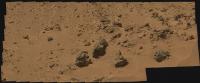
Regarding the posts above I would bet on aeolian deflation as a main process and some of the rocks could be aeolianites - just a guess from looking at the images
 Combination of sol 77 and sol 79 M100 pan - I think we get some foreground for the big pan ...
Big version here. (Stitching is somewhate lame at some points) |
|
|
|
|
|
|

|
Lo-Fi Version | Time is now: 25th April 2024 - 10:13 PM |
|
RULES AND GUIDELINES Please read the Forum Rules and Guidelines before posting. IMAGE COPYRIGHT |
OPINIONS AND MODERATION Opinions expressed on UnmannedSpaceflight.com are those of the individual posters and do not necessarily reflect the opinions of UnmannedSpaceflight.com or The Planetary Society. The all-volunteer UnmannedSpaceflight.com moderation team is wholly independent of The Planetary Society. The Planetary Society has no influence over decisions made by the UnmannedSpaceflight.com moderators. |
SUPPORT THE FORUM Unmannedspaceflight.com is funded by the Planetary Society. Please consider supporting our work and many other projects by donating to the Society or becoming a member. |
|