Printable Version of Topic
Click here to view this topic in its original format
Unmanned Spaceflight.com _ Tech, General and Imagery _ Elevation graphs
Posted by: brellis Feb 19 2011, 08:34 PM
It would be interesting to see the paths of our wonderful MERs depicted as elevation over time.
Spirit headed for the hills, and now Opportunity is headed for Endeavour
Posted by: ElkGroveDan Feb 19 2011, 09:06 PM
The necessary information is here on UMSF and in Google Mars if you have Eduardo's maps downloaded.
Posted by: elakdawalla Feb 19 2011, 09:52 PM
Acutally although there is partial route map information in Google Mars, Eduardo's Google Mars map only covers Opportunity from Victoria crater onward. I'd love to see Spirit's traverse and the rest of Opportunity's mapped out in Google Mars to the same fidelity, but don't have time. This would be a great project for someone who wanted to learn the ins and outs of Google Earth and receive the undying gratitude of other UMSF members...I'd be glad to tutor this hypothetical person in bringing in MOLA data & determining elevations....
Posted by: brellis Feb 19 2011, 09:59 PM
Dan, I don't have the skills to put such a graph together, and I don't have a University in my back pocket, hehe
Chapter 6 (page 33) of this doc from OSU has a nice description and graph until Sol 1890.
http://shoreline.eng.ohio-state.edu/publications/10thesis_karahayit.pdf
I have no idea how to make this type of graph, and such graphs are not readily visible in Google searches.
I will keep looking, just wonder if anyone knows a place to find them?
Posted by: brellis Feb 19 2011, 10:07 PM
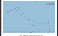
Here's an example:
edit - this is Spirit, comparing data from the rover to data from MRO
|
Posted by: ElkGroveDan Feb 19 2011, 11:00 PM

Aren't your MOLA tracks included in one of the kml files? I would assume it's just a matter of interpolating/guess-timating between the nearest two lines. I'll have a look at this after the kids go to bed and see if it's something I want to chew off.
Posted by: djellison Feb 20 2011, 12:27 AM
edit - this is Spirit, comparing data from the rover to data from MRO
No its not. It's comparing unadjusted rover telemetry with bundle-adjusted rover telemetry
Posted by: djellison Feb 20 2011, 12:50 AM
The Z values in these documents also represent the delta in height from the landing site
http://an.rsl.wustl.edu/mer/pages/osu/MERA_Traverse_Sol%201-2340.txt
Posted by: ElkGroveDan Feb 20 2011, 01:35 AM
Is it safe to assume these are driving days?
Posted by: brellis Feb 20 2011, 02:25 AM
thanks and I really wish I had the skills to put the Z values into graph form. I like doing things that take time and effort -- just ask anyone I've worked with on a piece of music!
(sorry Doug, I couldn't see the fine print on that pic  )
)
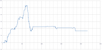
Posted by: djellison Feb 20 2011, 08:56 AM
Sol on the X axis, Altitude on the Y axis.
Import the TXT file to excel, scatter plot of sol v Z. Boom 
|
Posted by: brellis Feb 20 2011, 08:38 PM
Thanks dude! Later today, I'm going to try the same process, get some mad graph skills happening.
Powered by Invision Power Board (http://www.invisionboard.com)
© Invision Power Services (http://www.invisionpower.com)