MSL Post-conjunction: Drilling at Cumberland, Revisiting Point Lake and Shaler, site 6 cont'd, sols 272-323, May 12, 2013-July 4,2013 |

  |
MSL Post-conjunction: Drilling at Cumberland, Revisiting Point Lake and Shaler, site 6 cont'd, sols 272-323, May 12, 2013-July 4,2013 |
 May 18 2013, 06:41 PM May 18 2013, 06:41 PM
Post
#31
|
|
|
Solar System Cartographer  Group: Members Posts: 10153 Joined: 5-April 05 From: Canada Member No.: 227 |
Hmm, so I can be wrong!
Phil -------------------- ... because the Solar System ain't gonna map itself.
Also to be found posting similar content on https://mastodon.social/@PhilStooke Maps for download (free PD: https://upload.wikimedia.org/wikipedia/comm...Cartography.pdf NOTE: everything created by me which I post on UMSF is considered to be in the public domain (NOT CC, public domain) |
 |
 
|
|
May 19 2013, 12:29 PM
Post
#32
|
||
 Member Group: Members Posts: 215 Joined: 23-October 12 From: Russia Member No.: 6725 |
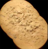
Cumberland in colored ChemCam on Sol 277
Attached thumbnail(s)
-------------------- My blog on Patreon
|
|
|
|
|
|
|
May 19 2013, 04:36 PM
Post
#33
|
|
|
Solar System Cartographer Group: Members Posts: 10153 Joined: 5-April 05 From: Canada Member No.: 227 |
Very nice - I am glad to see some more of these.
Phil -------------------- ... because the Solar System ain't gonna map itself.
Also to be found posting similar content on https://mastodon.social/@PhilStooke Maps for download (free PD: https://upload.wikimedia.org/wikipedia/comm...Cartography.pdf NOTE: everything created by me which I post on UMSF is considered to be in the public domain (NOT CC, public domain) |
|
|
|
| Guest_Actionman_* |
May 19 2013, 11:35 PM
Post
#34
|
|
Guests |
What do you see in this now Phil?
|
|
|
|
| Guest_Actionman_* |
May 20 2013, 02:05 PM
Post
#35
|
|
Guests |
Disregarding these what it looks like we now have two large lens artifacts on MAHLI.
0279MH0190001000C0 (edit: from photo too link) |
|
|
|
|
May 20 2013, 02:16 PM
Post
#36
|
|
|
Senior Member Group: Members Posts: 2511 Joined: 13-September 05 Member No.: 497 |
QUOTE (Actionman @ May 20 2013, 07:05 AM)  Disregarding these what it looks like we now have two large lens artifacts on MAHLI. Huh? Are you talking about sensor crud? Prove to me that you see something that hasn't been there since before launch. -------------------- Disclaimer: This post is based on public information only. Any opinions are my own.
|
|
|
|
|
May 20 2013, 02:29 PM
Post
#37
|
|
|
Senior Member Group: Members Posts: 2346 Joined: 7-December 12 Member No.: 6780 |
|
|
|
|
| Guest_Actionman_* |
May 20 2013, 04:38 PM
Post
#38
|
|
Guests |
QUOTE (mcaplinger @ May 20 2013, 09:16 AM) Huh? Are you talking about sensor crud? Prove to me that you see something that hasn't been there since before launch. why yes? I have not decided on endeavor of reaches but the question of black particles seem critical and new flat field data seems appropriate. |
|
|
|
|
May 20 2013, 05:48 PM
Post
#39
|
|
 Member Group: Members Posts: 222 Joined: 7-August 12 From: Garberville, CA Member No.: 6500 |
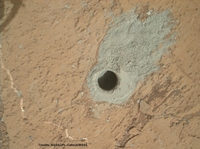
Sol 279 -
Close-up anaglyph of the drill hole. Seems to my eyes they offset MAHLI just enough for a good human eye separation value. Lots of detail in here. The anaglyph at least feels like kneeling just above the site. And there's a New JPL Video (May 16th, 2013) about drill sample processing. Gives a good idea of the drill size when Avi Okon is holding it in his hand...  Here's a cross-eye view for those without anaglyph specs.... 
-------------------- "We shall not cease from exploration, and the end of all our exploring will be to arrive where we started and know the place for the first time." -T.S. Eliot
|
|
|
|
|
May 20 2013, 08:48 PM
Post
#40
|
|
|
Senior Member Group: Members Posts: 2346 Joined: 7-December 12 Member No.: 6780 |
A zoom-in to the Cumberland drill hole created from this Sol 279 NavCam Right B image patched with this Sol 279 MAHLI image:
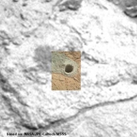 Link to animated gif. |
|
|
|
|
May 20 2013, 09:26 PM
Post
#41
|
|
|
Senior Member Group: Members Posts: 2511 Joined: 13-September 05 Member No.: 497 |
QUOTE (Actionman @ May 20 2013, 09:38 AM) why yes? I have not decided on endeavor of reaches but the question of black particles seem critical and new flat field data seems appropriate. I can't parse this completely, but note that these are raw images without any flat-field correction. I was unable to find any sensor crud in this image that wasn't there before launch. -------------------- Disclaimer: This post is based on public information only. Any opinions are my own.
|
|
|
|
|
May 20 2013, 09:58 PM
Post
#42
|
|
 Senior Member Group: Admin Posts: 4763 Joined: 15-March 05 From: Glendale, AZ Member No.: 197 |
QUOTE (Actionman @ May 20 2013, 07:05 AM) Disregarding these what it looks like we now have two large lens artifacts on MAHLI. 0279MH0190001000C0 (edit: from photo too link) If you have an observation that you'd like to share, please point out what you are talking about, otherwise your post is useless. -------------------- If Occam had heard my theory, things would be very different now.
|
|
|
|
|
May 20 2013, 11:59 PM
Post
#43
|
|
 Member Group: Members Posts: 754 Joined: 9-February 07 Member No.: 1700 |
In the Sol 275 PanCam image Emily uses in her recent (wonderful as always!) PS blog updating status for Curiosity there are mountains in the distance to the right of Mt Sharp. Probably a silly question: is that the rim of Gale Crater?
https://planetary.s3.amazonaws.com/assets/i...Sol274_pano.jpg
Reason for edit: Rule 3.2 violation
|
|
|
|
|
May 21 2013, 12:29 AM
Post
#44
|
|
 Senior Member Group: Members Posts: 3419 Joined: 9-February 04 From: Minneapolis, MN, USA Member No.: 15 |
QUOTE (brellis @ May 20 2013, 06:59 PM) ...is that the rim of Gale Crater? Yep. -the other Doug -------------------- The trouble ain't that there is too many fools, but that the lightning ain't distributed right. -Mark Twain
|
|
|
|
|
May 21 2013, 10:01 AM
Post
#45
|
|
|
Senior Member Group: Members Posts: 2346 Joined: 7-December 12 Member No.: 6780 |
Drilling the Sol 279 hole in time-lapse, as seen from Hazcam Front Left B:
 Animated GIF from the first 20 of a sequence of HazCam images. (EDIT: Sorry Paul for being almost perfectly in sync with your work on FB. This wasn't intended.) |
|
|
|
|

|
Lo-Fi Version | Time is now: 30th April 2024 - 07:57 AM |
|
RULES AND GUIDELINES Please read the Forum Rules and Guidelines before posting. IMAGE COPYRIGHT |
OPINIONS AND MODERATION Opinions expressed on UnmannedSpaceflight.com are those of the individual posters and do not necessarily reflect the opinions of UnmannedSpaceflight.com or The Planetary Society. The all-volunteer UnmannedSpaceflight.com moderation team is wholly independent of The Planetary Society. The Planetary Society has no influence over decisions made by the UnmannedSpaceflight.com moderators. |
SUPPORT THE FORUM Unmannedspaceflight.com is funded by the Planetary Society. Please consider supporting our work and many other projects by donating to the Society or becoming a member. |
|