Cloud hunting between flybys, more distant views |

  |
Cloud hunting between flybys, more distant views |
 Mar 21 2009, 09:05 PM Mar 21 2009, 09:05 PM
Post
#31
|
|
|
Senior Member  Group: Members Posts: 3516 Joined: 4-November 05 From: North Wales Member No.: 542 |
Nice one 'rivers. I was hoping someone would pull the Kraken images together to facilitate comparisons. There have been others that you don't show there, including a couple from the last few months. I think it would be a worthwhile project (beyond my skills) to assemble them all.
There are certainly quite obvious superficial differences between the 07 images and the 09 one in your collage, including some in the foot of Italy region. I don't attribute much significance to that yet because there are so many factors other than real surface changes that could affect the tone values in the images. |
 |
 
|
|
Mar 26 2009, 12:54 PM
Post
#32
|
|
|
Senior Member Group: Members Posts: 3516 Joined: 4-November 05 From: North Wales Member No.: 542 |
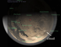
Southern cloud again - is it in the same place? (EDIT: 40S?)
http://saturn.jpl.nasa.gov/multimedia/imag...8/N00132562.jpg |
|
|
|
|
Mar 26 2009, 07:14 PM
Post
#33
|
||
|
Member Group: Members Posts: 699 Joined: 1-April 08 From: Minnesota ! Member No.: 4081 |
QUOTE (ngunn @ Mar 26 2009, 06:54 AM)  Southern cloud again - is it in the same place? (EDIT: 40S?) http://saturn.jpl.nasa.gov/multimedia/imag...8/N00132562.jpg Quick estimate below: appears to be between -45 and -60 S
|
|
|
|
|
|
|
Mar 27 2009, 12:03 AM
Post
#34
|
||
|
Member Group: Members Posts: 699 Joined: 1-April 08 From: Minnesota ! Member No.: 4081 |
Here is animation of the Titan cloud image mapping to the Celestia grid. In addition to the cloud Hotei arcus stands out, the latter appearing as a fan-shape bright object at the bottom center of the image.
|
|
|
|
|
|
|
Mar 29 2009, 09:55 PM
Post
#35
|
||
|
Member Group: Members Posts: 699 Joined: 1-April 08 From: Minnesota ! Member No.: 4081 |
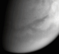
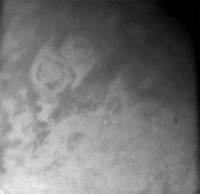
Heres another raw image (N00129016, taken 2-4-09) which displays Hotei arcus nicely!
|
|
|
|
|
|
|
Mar 30 2009, 05:53 AM
Post
#36
|
|
|
Member Group: Members Posts: 699 Joined: 1-April 08 From: Minnesota ! Member No.: 4081 |
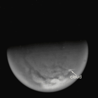
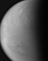
This a raw image from the Dec 21, 2008 T-49 flyby. The image is an inbound shot from 149,000 km of the Hotei region. ? is this a little cloud streak?
|
|
|
|
|
Mar 30 2009, 05:56 AM
Post
#37
|
|
 Senior Member Group: Members Posts: 1229 Joined: 24-December 05 From: The blue one in between the yellow and red ones. Member No.: 618 |
Extremely little.
-------------------- My Grandpa goes to Mars every day and all I get are these lousy T-shirts!
|
|
|
|
|
Mar 30 2009, 07:12 AM
Post
#38
|
||
|
Member Group: Members Posts: 699 Joined: 1-April 08 From: Minnesota ! Member No.: 4081 |
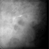
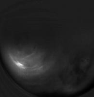
HA HA lets try that again!
N00126798.jpg was taken on December 21, 2008 and received on Earth December 22, 2008. The camera was pointing toward TITAN at approximately 145,059 kilometers away, and the image was taken using the CL1 and CB3 filters. It appears to show a little cloud train ... but is it or not!
|
|
|
|
|
|
|
Apr 13 2009, 08:12 AM
Post
#39
|
|
|
Senior Member Group: Members Posts: 3516 Joined: 4-November 05 From: North Wales Member No.: 542 |
The current 16 day orbits provide good mid-rev non-targeted flybys that are useful for much more that cloud hunting. Here's Menrva:
http://saturn.jpl.nasa.gov/multimedia/imag...9/N00133457.jpg EDIT: For some reason that one doesn't expand to the full res version. This one does: http://saturn.jpl.nasa.gov/multimedia/imag...9/N00133456.jpg |
|
|
|
|
Apr 17 2009, 07:32 AM
Post
#40
|
||
|
Member Group: Members Posts: 699 Joined: 1-April 08 From: Minnesota ! Member No.: 4081 |
And here is the approximate location of above raw image (slightly enhanced) on the Celestia Titan grid.
|
|
|
|
|
|
|
Apr 17 2009, 10:17 AM
Post
#41
|
|
 Senior Member Group: Moderator Posts: 3230 Joined: 11-February 04 From: Tucson, AZ Member No.: 23 |
QUOTE (ngunn @ Apr 13 2009, 01:12 AM) EDIT: For some reason that one doesn't expand to the full res version. This one does: That's because the other one was a SUM2 image, 512x512 pixels in size. -------------------- &@^^!% Jim! I'm a geologist, not a physicist!
The Gish Bar Times - A Blog all about Jupiter's Moon Io |
|
|
|
|
Apr 29 2009, 09:34 PM
Post
#42
|
|
|
Senior Member Group: Members Posts: 3516 Joined: 4-November 05 From: North Wales Member No.: 542 |
A belated thanks for that explanation.
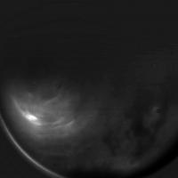
Clouds again: http://saturn.jpl.nasa.gov/multimedia/imag...9/N00135075.jpg |
|
|
|
|
Apr 29 2009, 09:57 PM
Post
#43
|
||
|
Solar System Cartographer Group: Members Posts: 10145 Joined: 5-April 05 From: Canada Member No.: 227 |
a bit of contrast fiddling with that last image.
Phil
-------------------- ... because the Solar System ain't gonna map itself.
Also to be found posting similar content on https://mastodon.social/@PhilStooke NOTE: everything created by me which I post on UMSF is considered to be in the public domain (NOT CC, public domain) |
|
|
|
|
|
|
Apr 30 2009, 03:04 AM
Post
#44
|
||
 Senior Member Group: Moderator Posts: 2785 Joined: 10-November 06 From: Pasadena, CA Member No.: 1345 |
I used the MT1 filtered image to subtract away from the combined N00135078 and N00135079 images.
(This idea is based on Jason's abstract; he ratio'd away the MT3 image to correct for the atmospheric lighting effects) Then I stretched the heck out of the resulting image:
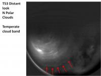
The lowest band (also seen faintly in Phil's image) is at about 40 N. (Menrva is the lighter gray spot.) I really have no clue what I am talking about. -Mike [EDIT: This is the N Polar region] -------------------- Some higher resolution images available at my photostream: http://www.flickr.com/photos/31678681@N07/
|
|
|
|
|
|
|
Apr 30 2009, 03:40 AM
Post
#45
|
|||
|
Senior Member Group: Moderator Posts: 2785 Joined: 10-November 06 From: Pasadena, CA Member No.: 1345 |
Another uber-stretch with a different set of images N00135074-76, MT1 is N00135077.
The lowest arc is still present (and better seen in this set)
-------------------- Some higher resolution images available at my photostream: http://www.flickr.com/photos/31678681@N07/
|
||
|
|
|
||
|

|
Lo-Fi Version | Time is now: 18th April 2024 - 04:42 AM |
|
RULES AND GUIDELINES Please read the Forum Rules and Guidelines before posting. IMAGE COPYRIGHT |
OPINIONS AND MODERATION Opinions expressed on UnmannedSpaceflight.com are those of the individual posters and do not necessarily reflect the opinions of UnmannedSpaceflight.com or The Planetary Society. The all-volunteer UnmannedSpaceflight.com moderation team is wholly independent of The Planetary Society. The Planetary Society has no influence over decisions made by the UnmannedSpaceflight.com moderators. |
SUPPORT THE FORUM Unmannedspaceflight.com is funded by the Planetary Society. Please consider supporting our work and many other projects by donating to the Society or becoming a member. |
|