Distant vistas, Endeavour, Iazu, and beyond |

  |
Distant vistas, Endeavour, Iazu, and beyond |
 Feb 8 2010, 11:25 PM Feb 8 2010, 11:25 PM
Post
#91
|
|
 Senior Member  Group: Members Posts: 4246 Joined: 17-January 05 Member No.: 152 |
Ngunn, using the proposed route we've seen from the abstract, I agree that we'd turn east before reaching the "crater beyond twin craters". But nothing stands out for that crater (it doesn't look especially fresh, eg), and I'm sure we'll encounter more similar sized ones on our trek. Of course we have to keep in mind that that's only a proposed route - we're not commited to it. Also the resolution of the proposed map isn't great.
In terms of the view, according to the contour map, the best views will be between the south and east. The rise around "crater beyond twin craters" is towards the SSW, so it shouldn't block our views towards the south to east. I don't know what kind of view we'll get to the SW (eg Bopolu), since I haven't seen a topo map in that direction. |
 |
 
|
|
Feb 8 2010, 11:45 PM
Post
#92
|
||
|
Senior Member Group: Members Posts: 4246 Joined: 17-January 05 Member No.: 152 |
QUOTE (Phil Stooke @ Feb 6 2010, 09:18 PM)  Meanwhile, here is another look at Iazu... I have labelled four hills, and the way hill D gets displaced relative to the other three suggests it must be on the far rim of Iazu. I agree D is on the far rim, and in this post I also claimed that the bits on the right are far rim. Here's a cross-eyed version of the long baseline stereo view for those red-green challanged out there:
|
|
|
|
|
|
|
Feb 9 2010, 04:02 AM
Post
#93
|
|
|
Solar System Cartographer Group: Members Posts: 10151 Joined: 5-April 05 From: Canada Member No.: 227 |
Right, I must have missed that! Very good. That far rim topography is the most distant we can see so far, I assume.
Phil -------------------- ... because the Solar System ain't gonna map itself.
Also to be found posting similar content on https://mastodon.social/@PhilStooke Maps for download (free PD: https://upload.wikimedia.org/wikipedia/comm...Cartography.pdf NOTE: everything created by me which I post on UMSF is considered to be in the public domain (NOT CC, public domain) |
|
|
|
|
Feb 12 2010, 02:52 PM
Post
#94
|
|
|
Senior Member Group: Members Posts: 3516 Joined: 4-November 05 From: North Wales Member No.: 542 |
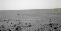
What's that on the right?
http://qt.exploratorium.edu/mars/opportuni...66P2368L7M1.JPG |
|
|
|
|
Feb 12 2010, 03:42 PM
Post
#95
|
|
|
Merciless Robot Group: Admin Posts: 8783 Joined: 8-December 05 From: Los Angeles Member No.: 602 |
Could you be more specific? Nothing jumps out at me.
-------------------- A few will take this knowledge and use this power of a dream realized as a force for change, an impetus for further discovery to make less ancient dreams real.
|
|
|
|
|
Feb 12 2010, 03:54 PM
Post
#96
|
||
 Senior Member Group: Members Posts: 2173 Joined: 28-December 04 From: Florida, USA Member No.: 132 |
QUOTE (nprev @ Feb 12 2010, 10:42 AM) Could you be more specific? Nothing jumps out at me. Maybe he's referring to that faint rise on the horizon.
|
|
|
|
|
|
|
Feb 12 2010, 03:58 PM
Post
#97
|
|
|
Senior Member Group: Members Posts: 3516 Joined: 4-November 05 From: North Wales Member No.: 542 |
There appears to be a hill on the horizon extending in from the right margin for about 10 percent of the image width. It's visible in 2 of the 3 filters.
EDIT: You got it centsworth. Looks like I'll just miss the answer - I'm off for a week's holiday now. |
|
|
|
|
Feb 12 2010, 04:05 PM
Post
#98
|
||
 Senior Member Group: Members Posts: 1083 Joined: 19-February 05 From: Close to Meudon Observatory in France Member No.: 172 |
QUOTE (nprev @ Feb 12 2010, 04:42 PM) Could you be more specific? Nothing jumps out at me. Thanks ngunn. Feature noticed also... Enjoy the enhancement 
|
|
|
|
|
|
|
Feb 12 2010, 04:33 PM
Post
#99
|
|
|
Solar System Cartographer Group: Members Posts: 10151 Joined: 5-April 05 From: Canada Member No.: 227 |
Comparing this with the circular pan from the other thread, this lies in the right direction to be Bopolu crater.
Phil -------------------- ... because the Solar System ain't gonna map itself.
Also to be found posting similar content on https://mastodon.social/@PhilStooke Maps for download (free PD: https://upload.wikimedia.org/wikipedia/comm...Cartography.pdf NOTE: everything created by me which I post on UMSF is considered to be in the public domain (NOT CC, public domain) |
|
|
|
|
Feb 12 2010, 09:04 PM
Post
#100
|
||
|
Senior Member Group: Members Posts: 4246 Joined: 17-January 05 Member No.: 152 |
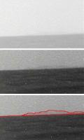
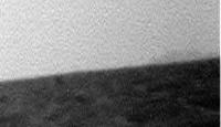
Here's my attempt at pulling Bopolu out of the haze and jpeg noise. Average of L5 and L7, contrast and 3x vertical stretches:
Bopolu in its entirety would subtend around 18 degrees for Oppy, while this bit's only about 2 degrees wide. So presumably we're seeing just one high part of the rim now. |
|
|
|
|
|
|
Feb 12 2010, 11:48 PM
Post
#101
|
|
|
Solar System Cartographer Group: Members Posts: 10151 Joined: 5-April 05 From: Canada Member No.: 227 |
I guess that's now the most distant bit of terrain we can see.
Phil -------------------- ... because the Solar System ain't gonna map itself.
Also to be found posting similar content on https://mastodon.social/@PhilStooke Maps for download (free PD: https://upload.wikimedia.org/wikipedia/comm...Cartography.pdf NOTE: everything created by me which I post on UMSF is considered to be in the public domain (NOT CC, public domain) |
|
|
|
|
Feb 13 2010, 12:16 AM
Post
#102
|
|
 Senior Member Group: Admin Posts: 4763 Joined: 15-March 05 From: Glendale, AZ Member No.: 197 |
QUOTE (Phil Stooke @ Feb 12 2010, 03:48 PM) I guess that's now the most distant bit of terrain we can see. ...unless we spot a planet or one of the moons in the sky. -------------------- If Occam had heard my theory, things would be very different now.
|
|
|
|
|
Feb 13 2010, 01:44 AM
Post
#103
|
|
|
Senior Member Group: Members Posts: 4246 Joined: 17-January 05 Member No.: 152 |
I was curious how the distance to Bopolu compares with the distance from Spirit to Gusev's rim, which is roughly 70 km if I'm right. I make the near rim of Bopolu to be about 58 km from Oppy. The far rim of Bopolu would probably be a bit farther than the Gusev rim from Spirit. So since we could easily see the Gusev rim when skies weren't too dusty, it's not surprizing that we can see out to Bopolu.
|
|
|
|
|
Feb 14 2010, 04:41 PM
Post
#104
|
||
|
Senior Member Group: Members Posts: 4246 Joined: 17-January 05 Member No.: 152 |
The new pancams from 2153 show more of Bopolu. Also the visibility is a bit better than on our first glimpse - I guess the dust has settled a bit. I've averaged the L7s and L5s, and pieced the frames together (the central strip is the average of all four overlapping frames):
Actual scale above, 3x vertical stretch below. This is still not the entire 18 degree extent of Bopolu... |
|
|
|
|
|
|
Feb 14 2010, 07:19 PM
Post
#105
|
|
|
Solar System Cartographer Group: Members Posts: 10151 Joined: 5-April 05 From: Canada Member No.: 227 |
Very nice, Fred! I hope it stays in view for a while, though it might become less visible when we are in the lower region east of here. Still, around the time we begin to descend we may get better views than this. Now we just need a really good atmospheric clearing! I was just looking back at the early views of Gusev's rim from the Columbia Hills - amazing views at times.
Phil -------------------- ... because the Solar System ain't gonna map itself.
Also to be found posting similar content on https://mastodon.social/@PhilStooke Maps for download (free PD: https://upload.wikimedia.org/wikipedia/comm...Cartography.pdf NOTE: everything created by me which I post on UMSF is considered to be in the public domain (NOT CC, public domain) |
|
|
|
|

|
Lo-Fi Version | Time is now: 25th April 2024 - 04:04 AM |
|
RULES AND GUIDELINES Please read the Forum Rules and Guidelines before posting. IMAGE COPYRIGHT |
OPINIONS AND MODERATION Opinions expressed on UnmannedSpaceflight.com are those of the individual posters and do not necessarily reflect the opinions of UnmannedSpaceflight.com or The Planetary Society. The all-volunteer UnmannedSpaceflight.com moderation team is wholly independent of The Planetary Society. The Planetary Society has no influence over decisions made by the UnmannedSpaceflight.com moderators. |
SUPPORT THE FORUM Unmannedspaceflight.com is funded by the Planetary Society. Please consider supporting our work and many other projects by donating to the Society or becoming a member. |
|