MSL Route Map |

  |
MSL Route Map |
 Oct 5 2012, 07:57 AM Oct 5 2012, 07:57 AM
Post
#76
|
||
|
Senior Member  Group: Moderator Posts: 4279 Joined: 19-April 05 From: .br at .es Member No.: 253 |
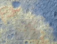
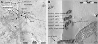
QUOTE (Michael Zeiler @ Oct 5 2012, 05:01 AM)  I was hoping to find a hypsographic map of the landing site but could not find any. So I made one using a HiRISE DEM and ArcGIS. The orange tones denote higher elevations, yellow is intermediate elevations, and blue marks lower elevations. I could only find a KML on this thread up to Sol 42; if someone directs me to a newer KML, I can update this. Nice job! And here's an up-to-date KML.
 Route_Map_Sol56.kml ( 5.59K )
Number of downloads: 1116
Route_Map_Sol56.kml ( 5.59K )
Number of downloads: 1116 |
|
 |
 
|
|
|
Oct 5 2012, 02:37 PM
Post
#77
|
||
|
Solar System Cartographer Group: Members Posts: 10151 Joined: 5-April 05 From: Canada Member No.: 227 |
Michael,
I love your map... but there's something seriously wrong with it. First the rover route is way off. Here is a version with Tesheiner's GE overlay superimposed. Second, I can't reconcile the contours with surface features in some areas. I suspect a difference in map projection or registration between base image and DEM. Can you take another look? Phil
-------------------- ... because the Solar System ain't gonna map itself.
Also to be found posting similar content on https://mastodon.social/@PhilStooke Maps for download (free PD: https://upload.wikimedia.org/wikipedia/comm...Cartography.pdf NOTE: everything created by me which I post on UMSF is considered to be in the public domain (NOT CC, public domain) |
|
|
|
|
|
|
Oct 5 2012, 03:18 PM
Post
#78
|
|
|
Newbie Group: Members Posts: 14 Joined: 9-November 09 Member No.: 5032 |
Thanks Phil, I think there is a registration issue. When I recently tried to mosaic the HiRISE DEMs (derived from stereo-pair imagery) in Gale Crater, there was some noticeable mis-registrations where the DEM boundaries met, so I was concerned about the georeferencing of this data. I also need to familiarize myself with Martian geoids (areoids?) and coordinate systems.
I'll study this problem and consult the HiRISE documentation some more. I can "fix" the registration by applying a delta x- and y- shift, but that's a very last resort. I looked at the base image layer versus DEM and they do seem to align well. The base image is PSP_010573_1755_RED.jp2 and the DEM is DTEEC_010573_1755_010639_1755_U01.IMG Do you know if the post-landing imagery is orthorectified? If so, can someone point me to it? I can use that instead. Tesheiner, thanks for the KML, I'll make a new map once I sort out the map alignment issue. A number of interesting map products can be derived from the DEMs: slope maps, gradient maps, aspect maps, viewshed maps, etc. I'll work on those soon after the map registration issues are resolved. I've got to get back to work now, I'll work on this some more tonight and over the weekend. |
|
|
|
|
Oct 5 2012, 03:40 PM
Post
#79
|
|
|
Newbie Group: Members Posts: 14 Joined: 9-November 09 Member No.: 5032 |
Whoops! I looked again at the background and the DEM and there is a misregistration between the two. I got confused by the hillshaded relief layer I generated from the DEM.
Curious, I'll look into this some more. Maybe the image is one of a stereopair and not orthorectified? |
|
|
|
|
Oct 5 2012, 07:17 PM
Post
#80
|
|
|
Member Group: Admin Posts: 976 Joined: 29-September 06 From: Pasadena, CA - USA Member No.: 1200 |
QUOTE (Michael Zeiler @ Oct 5 2012, 07:18 AM) ... I looked at the base image layer versus DEM and they do seem to align well. The base image is PSP_010573_1755_RED.jp2 and the DEM is DTEEC_010573_1755_010639_1755_U01.IMG Do you know if the post-landing imagery is orthorectified? If so, can someone point me to it? I can use that instead. ... If you downloaded the DEM from the HiRISE web site you will find the 1m and 25cm orthos included in the same directory. The orthos are perfectly registered to the DEMs. You will have some trouble in mosaicing DEMs that have part of Mt Sharp and part of the plains. Jmknapp has done an exceptionally good job at processing the available DEMs. Paolo -------------------- Disclaimer: all opinions, ideas and information included here are my own,and should not be intended to represent opinion or policy of my employer.
|
|
|
|
|
Oct 8 2012, 05:49 PM
Post
#81
|
||
|
Solar System Cartographer Group: Members Posts: 10151 Joined: 5-April 05 From: Canada Member No.: 227 |
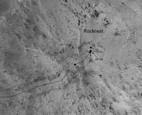
A very preliminary version of a route map for the Rocknest site. The base is best regarded as schematic, as the reprojections are not based on a high resolution DEM. So think of it as just a rough guide to activities here at Rocknest. For scale the double wheel track is nearly 3 m wide, but due to distortions the scale of the base image will vary from place to place.
Phil
-------------------- ... because the Solar System ain't gonna map itself.
Also to be found posting similar content on https://mastodon.social/@PhilStooke Maps for download (free PD: https://upload.wikimedia.org/wikipedia/comm...Cartography.pdf NOTE: everything created by me which I post on UMSF is considered to be in the public domain (NOT CC, public domain) |
|
|
|
|
|
|
Oct 18 2012, 10:46 PM
Post
#82
|
|
|
Solar System Cartographer Group: Members Posts: 10151 Joined: 5-April 05 From: Canada Member No.: 227 |
A lesson in route mapping!
In this post: http://www.unmannedspaceflight.com/index.p...st&id=28198 I showed a position for sols 29-37 which I had located based on one of my trademark circular panoramas. Then the MSL project released this map: http://mars.jpl.nasa.gov/msl/multimedia/images/?ImageID=4756 Based on that (overlaying it on my map) I amended my map as seen here: http://www.unmannedspaceflight.com/index.p...st&id=28282 Now we have a new HiRISE image of tracks: http://hirise.lpl.arizona.edu/images/2012/...8678_1755-3.jpg And guess what - when I overlay that, my original position was correct! I will post an update after the next move which will include this correction. Phil -------------------- ... because the Solar System ain't gonna map itself.
Also to be found posting similar content on https://mastodon.social/@PhilStooke Maps for download (free PD: https://upload.wikimedia.org/wikipedia/comm...Cartography.pdf NOTE: everything created by me which I post on UMSF is considered to be in the public domain (NOT CC, public domain) |
|
|
|
|
Oct 19 2012, 08:25 AM
Post
#83
|
|
 Member Group: Members Posts: 547 Joined: 1-May 06 From: Scotland (Ecosse, Escocia) Member No.: 759 |
Way to go, Phil...
|
|
|
|
|
Oct 26 2012, 12:56 AM
Post
#84
|
|
 Junior Member Group: Members Posts: 21 Joined: 21-August 12 From: the Netherlands Member No.: 6599 |
4 who wanna get more detail into GE:
. Zoom into the Crater & interactive Routemap for Google Earth  With images & videos UMSF members
root.kmz ( 10.47K )
Number of downloads: 1114Under constr. Still covers part Rovers & Landers layer |
|
|
|
|
Oct 30 2012, 01:17 PM
Post
#85
|
||
|
Solar System Cartographer Group: Members Posts: 10151 Joined: 5-April 05 From: Canada Member No.: 227 |
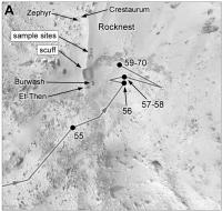
Map of the Rocknest area, now updated with the recently announced rock names.
Phil
-------------------- ... because the Solar System ain't gonna map itself.
Also to be found posting similar content on https://mastodon.social/@PhilStooke Maps for download (free PD: https://upload.wikimedia.org/wikipedia/comm...Cartography.pdf NOTE: everything created by me which I post on UMSF is considered to be in the public domain (NOT CC, public domain) |
|
|
|
|
|
|
Nov 19 2012, 02:38 PM
Post
#86
|
||
|
Solar System Cartographer Group: Members Posts: 10151 Joined: 5-April 05 From: Canada Member No.: 227 |
At last an updated route map! (the version with a scaled grid will come after a few more drives)
Phil
-------------------- ... because the Solar System ain't gonna map itself.
Also to be found posting similar content on https://mastodon.social/@PhilStooke Maps for download (free PD: https://upload.wikimedia.org/wikipedia/comm...Cartography.pdf NOTE: everything created by me which I post on UMSF is considered to be in the public domain (NOT CC, public domain) |
|
|
|
|
|
|
Nov 19 2012, 02:58 PM
Post
#87
|
||
|
Solar System Cartographer Group: Members Posts: 10151 Joined: 5-April 05 From: Canada Member No.: 227 |
And a final look at Rocknest. Treat the scales as approximate because of uncertainties in the image projection and compilation.
Phil
-------------------- ... because the Solar System ain't gonna map itself.
Also to be found posting similar content on https://mastodon.social/@PhilStooke Maps for download (free PD: https://upload.wikimedia.org/wikipedia/comm...Cartography.pdf NOTE: everything created by me which I post on UMSF is considered to be in the public domain (NOT CC, public domain) |
|
|
|
|
|
|
Nov 28 2012, 09:59 PM
Post
#88
|
||
|
Solar System Cartographer Group: Members Posts: 10151 Joined: 5-April 05 From: Canada Member No.: 227 |
Not much of a move but I decided to update the full map to add some names and the correction mentioned a few posts earlier.
Phil
-------------------- ... because the Solar System ain't gonna map itself.
Also to be found posting similar content on https://mastodon.social/@PhilStooke Maps for download (free PD: https://upload.wikimedia.org/wikipedia/comm...Cartography.pdf NOTE: everything created by me which I post on UMSF is considered to be in the public domain (NOT CC, public domain) |
|
|
|
|
|
|
Dec 4 2012, 08:50 PM
Post
#89
|
||
 Administrator Group: Admin Posts: 5172 Joined: 4-August 05 From: Pasadena, CA, USA, Earth Member No.: 454 |
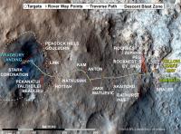
John Grotzinger kindly shared with me this map that he and several other MSL folks had in their talks yesterday, which contains lots more locale and science target names. Enjoy. I'd request no one blog it until I get a chance to post it in my blog (hopefully this afternoon), but hey, this is the Internet, you can do whatever you want
 (I am mostly talking to frequent forum lurker Alan Boyle here!) (I am mostly talking to frequent forum lurker Alan Boyle here!)
Attached thumbnail(s)
-------------------- My website - My Patreon - @elakdawalla on Twitter - Please support unmannedspaceflight.com by donating here.
|
|
|
|
|
|
|
Dec 4 2012, 10:00 PM
Post
#90
|
|
|
Solar System Cartographer Group: Members Posts: 10151 Joined: 5-April 05 From: Canada Member No.: 227 |
Thank you Emily! And John!
Phil -------------------- ... because the Solar System ain't gonna map itself.
Also to be found posting similar content on https://mastodon.social/@PhilStooke Maps for download (free PD: https://upload.wikimedia.org/wikipedia/comm...Cartography.pdf NOTE: everything created by me which I post on UMSF is considered to be in the public domain (NOT CC, public domain) |
|
|
|
|

|
Lo-Fi Version | Time is now: 26th April 2024 - 07:17 PM |
|
RULES AND GUIDELINES Please read the Forum Rules and Guidelines before posting. IMAGE COPYRIGHT |
OPINIONS AND MODERATION Opinions expressed on UnmannedSpaceflight.com are those of the individual posters and do not necessarily reflect the opinions of UnmannedSpaceflight.com or The Planetary Society. The all-volunteer UnmannedSpaceflight.com moderation team is wholly independent of The Planetary Society. The Planetary Society has no influence over decisions made by the UnmannedSpaceflight.com moderators. |
SUPPORT THE FORUM Unmannedspaceflight.com is funded by the Planetary Society. Please consider supporting our work and many other projects by donating to the Society or becoming a member. |
|