Moving south to Victoria |

  |
Moving south to Victoria |
 Mar 15 2006, 09:27 AM Mar 15 2006, 09:27 AM
Post
#1
|
||
|
Senior Member  Group: Moderator Posts: 4279 Joined: 19-April 05 From: .br at .es Member No.: 253 |
Bye, bye, Erebus!
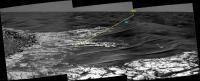
The journey south has started and I think it's time to start a new thread. This is a very first estimation of the current position after sol 760 drive, plotted on top of a previous route proposal; I will double-check that once the back-looking navcams are downlinked.
(Sol 758 "drive-direction" pancam mosaic) Edited: I measured the net drive to that point; it's about PS: Algorimancer, your Photogrammetry and RangeFinder Application is simply great!!! This post has been edited by Tesheiner: Mar 15 2006, 10:16 AM |
|
 |
 
|
|
|
Mar 15 2006, 10:25 AM
Post
#2
|
|
|
Senior Member Group: Members Posts: 2998 Joined: 30-October 04 Member No.: 105 |
Yes, onward bound! I hope Oppy gets Pancam images of the bedrock exposures as she moves away from away from this field of eroded craters. We need to document lateral changes in the Burns formation.
--Bill -------------------- |
|
|
|
|
Mar 15 2006, 04:09 PM
Post
#3
|
|
|
Junior Member Group: Members Posts: 45 Joined: 25-March 05 Member No.: 216 |
Seeing Oppy leaving Erebus is almost as good as seeing it arrive at Victoria (sometime this year we hope)
-------------------- My Open Office Website: http://www.openofficetips.com
|
|
|
|
|
Mar 15 2006, 04:22 PM
Post
#4
|
|
|
Member Group: Members Posts: 129 Joined: 25-March 05 Member No.: 218 |
Wasn't there supposed to be a certain point where the terrain begins to slope to the south and there was to be a "hell of a view" of the plains (and Victoria) spread out in view before us? Where was this to occur in relation to where Oppy currently is? Or am I recalling something else?
|
|
|
|
|
Mar 15 2006, 04:25 PM
Post
#5
|
|
|
Solar System Cartographer Group: Members Posts: 10172 Joined: 5-April 05 From: Canada Member No.: 227 |
That's right, but it's probably a few hundred meters ahead.
Phil -------------------- ... because the Solar System ain't gonna map itself.
Also to be found posting similar content on https://mastodon.social/@PhilStooke Maps for download (free PD: https://upload.wikimedia.org/wikipedia/comm...Cartography.pdf NOTE: everything created by me which I post on UMSF is considered to be in the public domain (NOT CC, public domain) |
|
|
|
|
Mar 15 2006, 04:31 PM
Post
#6
|
|
 Senior Member Group: Members Posts: 2173 Joined: 28-December 04 From: Florida, USA Member No.: 132 |
QUOTE (RedSky @ Mar 15 2006, 11:22 AM)  Wasn't there supposed to be a certain point where the terrain begins to slope to the south and there was to be a "hell of a view" of the plains (and Victoria) spread out in view before us? Where was this to occur in relation to where Oppy currently is? Or am I recalling something else? As I recall it's near the midpoint between Erebus and Victoria. That should be an interesting point for 360 degree panarama. (Has anyone thought of that?) |
|
|
|
|
Mar 16 2006, 02:49 PM
Post
#7
|
|
|
Member Group: Members Posts: 252 Joined: 27-April 05 Member No.: 365 |
Interesting horizontal 'layering' in a dune here, I can't recall seeing it so clearly elsewhere(until this side of Erebus):
http://marsrovers.jpl.nasa.gov/gallery/all...KEP0695L0M1.JPG |
|
|
|
|
Mar 16 2006, 10:29 PM
Post
#8
|
|
|
Member Group: Members Posts: 866 Joined: 15-March 05 From: Santa Cruz, CA Member No.: 196 |
QUOTE (Burmese @ Mar 16 2006, 02:49 PM) Interesting horizontal 'layering' in a dune here, I can't recall seeing it so clearly elsewhere(until this side of Erebus): http://marsrovers.jpl.nasa.gov/gallery/all...KEP0695L0M1.JPG I remember seeing a lot of this most of the way between Endurance and now, but this is probably the most consistent and smoothest example before us. I assume this layering depicts the cyclic changes in weather patterns related to sand deposition. As the dunen get eroded, it reveals the strata created by earlier episodes where dunes get cemented by relatively stable weather and then covered during by episodes of higher sand transport. The question which I hope someone here could answer, is how long these episodes are likely to be (are talking about episodes separated by decades long weather changes, or much longer changes due to pole procession?) Or maybe this hypothesis is off-base, just a guess... |
|
|
|
|
Mar 16 2006, 10:43 PM
Post
#9
|
|
 Senior Member Group: Members Posts: 2488 Joined: 17-April 05 From: Glasgow, Scotland, UK Member No.: 239 |
QUOTE (atomoid @ Mar 16 2006, 10:29 PM) I remember seeing a lot of this most of the way between Endurance and now, but this is probably the most consistent and smoothest example before us. I assume this layering depicts the cyclic changes in weather patterns related to sand deposition. As the dunen get eroded, it reveals the strata created by earlier episodes where dunes get cemented by relatively stable weather and then covered during by episodes of higher sand transport. The question which I hope someone here could answer, is how long these episodes are likely to be (are talking about episodes separated by decades long weather changes, or much longer changes due to pole procession?) Or maybe this hypothesis is off-base, just a guess... Opinions seem to vary between slow and very slow movement - I'd buy even s-l-l-l-o-o-o-o-w-e-r. Precession of the poles and similar global changes strike me as being about right, but I'm sure there are other opinions. BTW, I noticed an interesting article in New Scientist today regarding crater distribution and so forth - I'll post in the LPSC thread rather than here, though! Bob Shaw -------------------- Remember: Time Flies like the wind - but Fruit Flies like bananas!
|
|
|
|
|
Mar 17 2006, 08:47 AM
Post
#10
|
|
 Senior Member Group: Members Posts: 1619 Joined: 12-February 06 From: Bergerac - FR Member No.: 678 |
QUOTE (Burmese @ Mar 16 2006, 03:49 PM) Interesting horizontal 'layering' in a dune here, I can't recall seeing it so clearly elsewhere(until this side of Erebus): http://marsrovers.jpl.nasa.gov/gallery/all...KEP0695L0M1.JPG I've ever seen this sort of "layering" dune. On my website, there is a color example of this dune (who are everywher around the landing site) : 
-------------------- |
|
|
|
|
Mar 17 2006, 08:55 AM
Post
#11
|
|
|
Senior Member Group: Members Posts: 2488 Joined: 17-April 05 From: Glasgow, Scotland, UK Member No.: 239 |
QUOTE (Ant103 @ Mar 17 2006, 08:47 AM) I've ever seen this sort of "layering" dune. On my website, there is a color example of this dune (who are everywher around the landing site) : Thinking about it, the 'layering' may be an artefact of the psaltation of the particles involved, with - putting it crudely - bigger lumps simply failing to climb the hill. Bob Shaw -------------------- Remember: Time Flies like the wind - but Fruit Flies like bananas!
|
|
|
|
|
Mar 17 2006, 10:08 AM
Post
#12
|
||
|
Senior Member Group: Moderator Posts: 4279 Joined: 19-April 05 From: .br at .es Member No.: 253 |
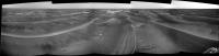
Oppy drove some 50m southwards (heading ~160º) on sol 762 and is currently at aprox. 25m of the outcrop on the center of this navcam pano.
|
|
|
|
|
|
|
Mar 17 2006, 10:10 AM
Post
#13
|
|
|
Founder Group: Chairman Posts: 14432 Joined: 8-February 04 Member No.: 1 |
Need to see some of the look-back-Navcams to really call it, but the driving actually looks a lot easier than I was expecting around here
 Doug |
|
|
|
|
Mar 17 2006, 10:16 AM
Post
#14
|
|
|
Senior Member Group: Moderator Posts: 4279 Joined: 19-April 05 From: .br at .es Member No.: 253 |
Seems they are simply following the "valleys". The dunes in this area have a mean heading of 160º-170º, so that's the direction they are driving.
|
|
|
|
| Guest_Sunspot_* |
Mar 17 2006, 10:43 AM
Post
#15
|
|
Guests |
Alot of the image is missing, but do these dunes look alot smaller than the ones Opportunity encountered on it's way to Erebus? I thought they would be much bigger.
http://qt.exploratorium.edu/mars/opportuni...RXP2370L2M1.JPG |
|
|
|
|

|
Lo-Fi Version | Time is now: 30th May 2024 - 11:26 AM |
|
RULES AND GUIDELINES Please read the Forum Rules and Guidelines before posting. IMAGE COPYRIGHT |
OPINIONS AND MODERATION Opinions expressed on UnmannedSpaceflight.com are those of the individual posters and do not necessarily reflect the opinions of UnmannedSpaceflight.com or The Planetary Society. The all-volunteer UnmannedSpaceflight.com moderation team is wholly independent of The Planetary Society. The Planetary Society has no influence over decisions made by the UnmannedSpaceflight.com moderators. |
SUPPORT THE FORUM Unmannedspaceflight.com is funded by the Planetary Society. Please consider supporting our work and many other projects by donating to the Society or becoming a member. |
|