Printable Version of Topic
Click here to view this topic in its original format
Unmanned Spaceflight.com _ Opportunity _ Concepción
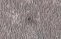
Posted by: fredk Jan 27 2010, 03:48 AM

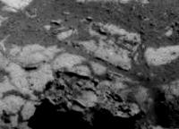
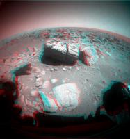
My, that's one big, jagged, gaping hole:

|
Posted by: brellis Jan 27 2010, 06:29 AM
Is there a significant risk of getting stuck if Oppy rolls over one of these rocks?
Posted by: Stu Jan 27 2010, 06:45 AM
Wow, will ya look at that...
http://twitpic.com/zysql/full
Are they shattercones littering the area? Or has the rock just fractured at sharp angles? Can't wait to see some of those stones in more detail...
Posted by: ustrax Jan 27 2010, 11:10 AM
What a pretty big mess we have here...watching at all those rocks and thinking about Stu one image comes to mind...
http://www.youtube.com/watch?v=q_3ngcLf0WQ&feature=related

Posted by: Phil Stooke Jan 27 2010, 02:09 PM
"Are they shattercones littering the area?"
I wouldn't expect shatter cones in a tiny impact like this.
Phil
Posted by: Stu Jan 27 2010, 02:21 PM
Fair enough, thanks Phil.
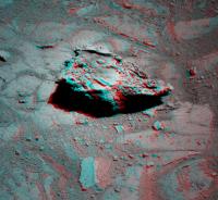
Posted by: Stu Jan 27 2010, 02:51 PM
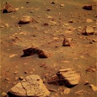
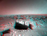
Hmmm. Interesting rock on the bottom of one of the latest images... Wonder if this is what we'll see a lot more of when we get to the crater itself..?
|
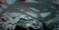
|
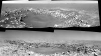
Posted by: Ant103 Jan 27 2010, 03:52 PM
Sol 2133 navcam panoramic 
http://www.astrosurf.com/merimages/Opportunity/2010/Sol2136-pano.jpg
Yes, we're very near Conception, and we see clearly the "star" structure of the ring of ejectas, I think. And we can see like a dark streak on the horizon Endeavour. Can't wait to have the pancam's 
Posted by: Phil Stooke Jan 27 2010, 04:36 PM
Fourmidable!
And here it is in a polar projection.
Phil
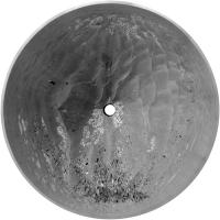
|
Posted by: climber Jan 27 2010, 05:59 PM
We are sitting now on one of the most scenic place either rovers ever been on Mars. A fresh 1000 years crater, opening view to our destination, others big craters in sight, Victoria still to find in our rear mirror. We'll be there for a while, guys.
Time to open a new topic. Enjoy your stay.
Posted by: Phil Stooke Jan 27 2010, 07:09 PM
Many, maybe most of the rocks seem to be sitting on the drifts - very few seem embedded. And there's no sign I can see yet of wind tails behind rocks or moat-like troughs wrapping around the base of rocks (compare with the Barnacle Bill area at Pathfinder to see what I'm referring to). I take that to mean that the drifts have hardly changed since the crater formed. If the drifts were marching across the surface, even 1 cm per year, I would expect to see more buried rocks or wind sculpting of drift around rocks. Pancams might prove me wrong. But I think this shows the big drifts are fairly static on thousand year time scales.
Phil
Posted by: ElkGroveDan Jan 27 2010, 07:20 PM

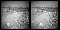
I'd say no. This is the reverse of the situation Spirit is in where LACK of traction is the problem. Here we have abundant traction. Remember the rovers were designed with an eye toward the only ground observations of Mars we had until that time -- the Viking and Pathfinder sites. And as we all recall those sites consisted of scattered fractured rock as far as the eye could see. It's why they tested the rovers at a site in Death Valley California known as "Mars Hill" (see attached image) which consists of an extreme swath of fractured basalt. This debris field that Opportunity is approaching is ideal for the MERs, however I have no doubt that the approach will be cautious nonetheless.
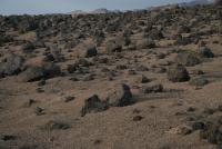
|
Posted by: Phil Stooke Jan 27 2010, 07:28 PM
That's right, and they're pretty small rocks too for the most part.
Phil
Posted by: NW71 Jan 27 2010, 07:57 PM
Is that the reason this crater is believed to be only about 1,000 years old?
Posted by: ElkGroveDan Jan 27 2010, 08:00 PM
...or that the crater is less than 1000 years old. It's all relative and I have yet to see any data that pins any of the relationships down to an absolute.
Posted by: volcanopele Jan 27 2010, 09:30 PM
What data could Opportunity collect that might help pin the age down? I take it radioisotope ratios are out
Posted by: Stu Jan 27 2010, 09:54 PM
Yep, (Frasier Crane voice)... I'm listening...
Some fun for now...

|
Posted by: ElkGroveDan Jan 27 2010, 10:15 PM
Exactly. So why are they so certain that it's 1000 years old? Do they have a better crystal ball than me?
Posted by: hendric Jan 27 2010, 10:55 PM
Is it me, or do the rocks around the crater even look "fresher"? There aren't any small cobbles around each larger rock, for example.
Posted by: brellis Jan 27 2010, 11:03 PM
EGDan, thanks for the info on rock sizes and thank goodness Oppy's rolling on solid ground! I had the pleasure of being tickled by a rover rolling over me at the JPL Open house a few years ago, so I know she can at least climb over a bump-on-a-log my size!
Posted by: Phil Stooke Jan 27 2010, 11:23 PM
"why are they so certain that it's 1000 years old? "
I wouldn't be overly concerned about this - it's probably just a guess, meaning its preserved ejecta deposit suggests it is most likely very young compared with the other little craters we've seen frequently in the past. Actual number of years - not important. Like when I say I'm 39. Still. Or was it 49?
Phil
Posted by: marswiggle Jan 27 2010, 11:24 PM
Made this HiRise anaglyph of Concepcion, magnified to 200 %. The inside of the crater seems to be completely enshrouded with the dark dust typically filling many smaller Meridiani craters.
Somehow I too have hard time imagining that this crater was just 994 years old when Oppy landed. (Excuse my literal interpretation.)
|
Posted by: glennwsmith Jan 28 2010, 01:30 AM
Stu, cool picture. I think we can see the "ray" of ejecta that goes off to the southeast. With this photo, one really gets the feeling of something having smacked into Mars at a very high velocity.
Posted by: Stu Jan 28 2010, 06:18 AM
GREAT 3D overhead view of Concepcion, thanks for posting that!
Posted by: climber Jan 28 2010, 12:09 PM
No big relief differences to expect any significant wind change effects = cleaning events. I would expect some slight effects around Concepción the only "relief" around.
BTW we didn't saw the full deck for quite a while to assess sand deposition. IF we get this 360° panorama we'll probably get more infos on this since the deck is always included.
Globally I'll add that, even if marswiggle 3D is nice, the view from the ground is much better than I was expecting.
Posted by: ustrax Jan 28 2010, 12:36 PM
OK, thanks Fred, so Bopulu is on Oppy field of view is that correct? Can someone point where to look if the crater was visible?
New pancams are down but no sign of the horizon...or Concepción

Posted by: MahFL Jan 28 2010, 02:58 PM
We would not want to jam a wheel up again with a potato would we ?
Posted by: ElkGroveDan Jan 28 2010, 03:04 PM
The "potato" jam issues have been caused by small rocks mixed with lots of soft sand that the wheels were buried in. It's always something to watch for, but these environs involve firmer ground. It's difficult to imagine a way of placing a rock inside a wheel cavity unless that wheel is mired in something. As noted previously, this is the kind of terrain the rovers were designed FOR.
Posted by: Marz Jan 28 2010, 07:55 PM
edit: sorry, the MI was from sol 2119. I was just hoping they'd find another RAT target here.Looks like the RAT found another worthy target?http://qt.exploratorium.edu/mars/opportunity/micro_imager/2010-01-27/1M316297395EFFA9X7P2996M2M1.JPGAre we in for an mossbauer integration soak now? I presume the goal is to continue measuring the sulfate rocks as we work our way down through the layers.
Is it just me, or are there less and less blueberries as we go?
Posted by: climber Jan 28 2010, 09:44 PM
We've got Hills now, why do you want Blueberries?
Posted by: climber Jan 28 2010, 09:57 PM
Nice Stu, but you're posting in Oppy's 
Posted by: Stu Jan 28 2010, 10:01 PM
Sorry, posted in haste. Deleted and put in the right place, thanks Climber.
Posted by: ilbasso Jan 29 2010, 03:29 AM
[pedant mode]
Sorry to interrupt the fun, but wasn't the Heat Shield impact the "freshest crater yet explored"?
[/pedant mode]
Carry on, fellas, beautiful images!!
Posted by: fredk Jan 29 2010, 03:32 AM
Oooohhh...

|
Posted by: ElkGroveDan Jan 29 2010, 04:35 AM
That's a really good anaglyph Fred. It's one of those perfect stereo images that you would include in an oooh-ahhh slide show.
Stu?
Posted by: mhoward Jan 29 2010, 04:59 AM
That is really cool.
http://www.flickr.com/photos/marscat/4313238544/sizes/l/
http://mmb.unmannedspaceflight.com/MERB2138Navcam.mov (3.2MB)
Posted by: brellis Jan 29 2010, 05:12 AM
http://www.merriam-webster.com/dictionary/posthaste
Posted by: Stu Jan 29 2010, 06:49 AM
Quick n dirty 3D portrait of Concepcion... what a fascinating place... Doesn't line up perfectly, I'll try again after work. Apologies in advance for any eye strain...

|
And a quick colourised view...
http://twitpic.com/109yn9/full
Posted by: glennwsmith Jan 29 2010, 07:58 AM
Ground truth -- could this be the most exquisite example thus far in the history of astronomy?
Posted by: nprev Jan 29 2010, 08:12 AM
What a stunning vista in 3D!!!
I know the real science treasures here should be the shallow bedrock that's been presumably tossed up, but definitely want to get a closer look at that terrific pentagonal/home-plate-shaped (from the top) layered rock @ right lower center. Looks like a cake of some kind...tiramisu?
Oh, for just an hour alone with that rock & a geologist's hammer...
Posted by: Ant103 Jan 29 2010, 09:02 AM
Own version of the Sol 2136 pan
http://www.astrosurf.com/merimages/Opportunity/2010/Sol2138-pano.jpg
YES ! That's a great place to be ! This crater, the two other on the horizon
Posted by: Tesheiner Jan 29 2010, 09:37 AM
What a great view is opening up at the horizon!
I'm 100% sure we'll get some pancams, if not from this exact site, when we stop to start some "sniffing".
Meanwhile, here's a polar view of MHoward's mosaic.

|
Posted by: climber Jan 29 2010, 12:03 PM
This one will be as hard to navigate as Bonneville back in 2004 @Gusev
Posted by: JayB Jan 29 2010, 02:12 PM
Is it just me or does that ejecta look pretty old (like a lot more than 1000y) and weathered?
Posted by: charborob Jan 29 2010, 02:14 PM
Even if this crater appears (relatively) young, its bottom looks like it's covered with dust already.
Seeing this young crater surrounded by shattered boulders, a nagging question comes to my mind. How come we haven't seen a field of boulders around Victoria or Endurance? The formation of these craters must have blasted the bedrock and thrown broken rock all over the place. Where have the boulders gone? Covered with dust? Crumbled to sand?
Posted by: NW71 Jan 29 2010, 02:50 PM
It's a good question charborob. If you don't mind, I'm going to have a guess before the experts put me right!
(Speculation mode on!)
Firstly, could it be that the impact site is on different ground/bedrock to the other craters you mentioned? Or that the meteorite that struck had a different mineral content?
Secondly, I wonder if the size of impact makes a difference? I am a newbie here so please correct me but I seem to think that Opportunity has passed other similar sized craters with similar rocks strewn around on its recent travels?
Thirdly, I presume erosion does occur on mars and thus if this is a very young crater trying to age it would be of some use to us. I'm unsure if any guesses at the age of victoria and endeavour have been made. (Statto mode on) but if Concepcion is 1,000 years old and those rocks have each lost say 10 cubic centimetre (and that is not a lot) of material then a crater which is 1 million years old will have lost 10,000 cubic centimetres, a crater 1 billion years old will have seen each rock lose 10,000,000 cubic centimetres (10 cubic metres) (Statto mode off)
This is why Concepcion's age could matter. If it is 100 years old or 10,000 years old those figures above change dramatically!
Marquette Island would be different to this as I seem to recall it is a very hard material and hence less likely to erode at a similar rate.
Personally, I suspect a mixture of points 2 and 3.
I must stress I have very little evidence (other than that stated above) to support these views but I just wished to see if I'm beginning to think along the right tracks. I look forward to the class acts on this forum putting me right!
(Speculation mode off)
Neil 
Posted by: Phil Stooke Jan 29 2010, 02:51 PM
Yes, I believe crumbled to sand. They are rather weakly cemented sandstones, and ultimately that's what happens to them. Compare with Bonneville crater at Spirit's landing site, probably at least a billion years old and still surrounded by lots of rocky ejecta, but it's basalt.
My opinion of this location: the rocks hold no interest as we've seen it all before. The interest is in the geomorphology of the crater, for comparison with older craters along the route like Alvin and Viking. That can be taken care of with stereo imaging from 2 or 3 points around it, and then it's time to move on.
Phil
Posted by: Stu Jan 29 2010, 04:31 PM
Some more 3D images in my blog post here http://roadtoendeavour.wordpress.com/2010/01/29/welcome-to-concepcion-crater if anyone wants a look...
Posted by: ustrax Jan 29 2010, 04:44 PM
Here's a new toy for Stu...
http://qt.exploratorium.edu/mars/opportunity/pancam/2010-01-28/1P317987360EFFAB00P2551R1M1.JPG
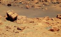
Posted by: Stu Jan 29 2010, 05:10 PM
Thanks for reminding me! I saw that this morning but real life got in the way... Interesting chunka rock, for sure...
|
Posted by: ustrax Jan 29 2010, 05:21 PM
Does it have a name?! Does it have a name?!
Posted by: Oersted Jan 29 2010, 05:33 PM
When I look at Concepción I can almost hear the BANG! when it was created. This crater is fresh!
ADMIN EDIT
Posted by: Marz Jan 29 2010, 05:44 PM
KABLAM! It's so fascinating to see the rays of rocky debris spreading out from the crater. Any luck these rays would be sorted by depth, with top layers being more fragmented and spread further than the deeper layers, or is crater formation much more chaotic?
Posted by: Tesheiner Jan 29 2010, 08:14 PM
Actually, it has.
02138::p2551::24::6::0::0::6::2::14::pancam_Ubay_L257R167
And another one, imaged on sol 2136, is named "Anda".
Now, Rui, it's your turn to find what do they mean.
Posted by: centsworth_II Jan 29 2010, 08:25 PM
Is Concepción (bottom) really very different from Fram (top)? The pictures are not to the same scale, but both craters look to be in the same size and age ballpark. (Note Endurance crater behind Fram's right side.)
|
http://www.unmannedspaceflight.com/index.php?showtopic=168
Posted by: volcanopele Jan 29 2010, 08:31 PM
It is a little different. The main ripples of the Meridiani plains are overlapping the rim at Fram, so that you have dunes lying at the top of the crater wall. You can also see ripples on the crater floor at Fram. At Concepción, the inner ejecta field lies on top of the dunes and I don't see any small ripples inside the crater.
That's just combining what I see with what was said on Emily's blog regarding the order of magnitude age estimate.
Posted by: Tesheiner Jan 29 2010, 08:47 PM
OT:
Ah! It was a good read and a nice time to remember the old days when we though Endurance was almost beyond the limits...
This is from the above thread:

Posted by: avkillick Jan 29 2010, 09:32 PM
Ubay and Anda are districts in Bohol province in the Philippines
Posted by: nprev Jan 29 2010, 09:37 PM
Right, forgot that the Phillippines were going to be the theme for Concepcion, thanks!
Very apropros; the archipelago has something like 7000 islands, IIRC.
Posted by: Joffan Jan 29 2010, 09:43 PM
For the old-school among us, here's a cross-eyed stereogram of Concepcion... it is indeed a pretty spot - will we rove to the rim?
|
Posted by: ngunn Jan 29 2010, 10:07 PM
Thanks - I really like that. Nice not to to have the distracting colours for a change.
Posted by: glennwsmith Jan 29 2010, 11:33 PM
Centsworth, thanks for digging up Fram! They DO seem remarkably similar, with perhaps the difference being age. So if Concepcion is 1K years old, how old is Fram? 10K? 100K?
And way cool to see Endurance in the background! Seems like a lifetime ago that we rolled to its edge.
Posted by: john_s Jan 29 2010, 11:41 PM
I'm having trouble with these very young ages. Meridiani Planum is lightly cratered by Martian standards but it still has enough craters that I'd be surprised if the age of the surface we see was less than 100 million years, say. If that's the case, only one crater in 100 should be less than a million years old, and only one crater in 100,000 should be less than a thousand years old. As we've passed far fewer than 100,000 craters of Concepción's size (maybe more like 100?), the odds of it being so young seem very slim.
All these numbers are WAGs but I doubt that they are wrong by a factor of 1,000...
John
Posted by: ustrax Jan 29 2010, 11:49 PM
wohoo guys! we're once more on Mars!!

and not the Philipines Nick, Bohol man, Bohol, forgot it?...
http://www.unmannedspaceflight.com/index.php?s=&showtopic=6404&view=findpost&p=153846
Posted by: sgendreau Jan 30 2010, 12:10 AM
John
IIUC, Opportunity's tracks are already accumulating dust. To my untrained eye there's not much dust around the cobbles at Concepcion. Wouldn't even a thousand-year-old crater show more accumulation? Let alone an older one?
(not a geologist)
Posted by: ElkGroveDan Jan 30 2010, 12:40 AM
Craters of what age? If every impact over the history of Meridiani is the range of our sample then I'd say we've passed a whole lot more than a 100. How many "http://photojournal.jpl.nasa.gov/catalog/PIA12353s" have we passed and not observed? I don't dispute your methodology or reasoning John but I do believe that we simply don't have enough data points or a truly thorough study and analysis. I accept that the global cratering rates and ranges are applicable on a body like the moon where erosion is essentially non-existent. With Mars in general and with Meridiani specifically, we must acknowledge however that erosion and mass-wasting ARE occurring and that the rates over a planetary time scale are far from static. Further we still have no real solid understanding of the regional variations in erosion and deposition on Mars. Evidence of impacts would erode far faster in a body of water than across a wind swept plain. Was Meridiani a long lived sea? Was that sea static or subject to eddies and currents? Or was it nothing more than a temporary swamp? I've seen some truly inspiring science and studies of Martian geomorphology over the past decade that propose intriguing answers to some of these questions, but we honestly have to admit that there are still so many unanswered questions in a region like Meridiani. I don't feel that it's possible to even estimate the absolute age of a crater like this.
I am however just an armchair observer and you are a respected professional who does this for a living so no disrespect is intended.
Posted by: DFinfrock Jan 30 2010, 12:47 AM
Thanks for the cross-eyed view. I don't always have the red-blue stereo glasses available. But this always works.
David
Posted by: nprev Jan 30 2010, 12:48 AM
Rui, my apologies. Not only did I neglect to credit you with the theme for Concepcion, I did forget that the names were to be the neighborhoods of Bohol. Mia maxima culpa, man!
Posted by: MarkG Jan 30 2010, 01:16 AM
In evaluating Concepcion, the main efforts will be in the Geomorphology (as stated above), plus a look-see for any evidence of the parent meteorite body. (There might also be an APXS exam of the sulfur-salt pavement fragments to see if composition is changing during the long traverse.)
One of the interesting aspects of this crater is the "disturbed" look of the nearby dunes. They seem to still bear the scars of the seismic shock and the impact of debris from the impact. It is reasonable to speculate that no major dune-moving wind event has occurred since this crater was formed. There is an implication that dune-moving high wind events only occur during a different climatic period than Mars is in now, perhaps only every few tens of thousands of years (due to variations in Mars' orbit and precession of its axis). About the only thing missing from the site (from immediately after the impact) is the very fine and light white sulfur dust from the fragmentation of the pavement.
Posted by: Phil Stooke Jan 30 2010, 01:55 AM
My polar version of Ant's nice panorama posted above.
Phil

|
Posted by: john_s Jan 30 2010, 04:11 AM
No disrespect taken! Still, I *think* my point holds. Note that my WAG age for the *surface* was 100 million years. The rocks of Meridiani are likely to be three billion years old or more, 30 times older, so if you counted every crater since the rocks formed, there would be ~30 times as many as my estimate- most of them have indeed eroded away.
Thanks to HiRISE, we do have a handle on the current rate of formation of small craters on Mars, so someone ought to be able to estimate the chance that a crater of this size would have formed in the last few thousand years on the few square kilometers that Oppy has explored...
John
Posted by: Tom Tamlyn Jan 30 2010, 07:42 AM
>Thanks to HiRISE, we do have a handle on the current rate of formation of small craters on Mars
I thought that this understanding was based on multiple MOC observations of substantially identical targets. I think I recall Malin or Edget discussing this in the hastily-scheduled (and very moving) press conference after MGS was lost. Or has HiRISE taken the understanding substantially further?
TTT
Posted by: Stu Jan 30 2010, 08:34 AM
You're a messed up little rock, aren't you..?

|
Posted by: Tesheiner Jan 30 2010, 09:52 AM
Ok, I finished moving some posts from this and the "route map" thread to the new "Distant vistas".
From now on: this thread for discussion about Concepcion, "Distant vistas" for talks about the sights at the horizon while we are stopped at this site and also when we continue moving forward, and the "route map" for, er, the route map and related stuff.
Posted by: Tesheiner Jan 30 2010, 11:19 AM
Do you want Concepción in color? Just wait for the next images update. 
02140::p2368::21::48::0::0::48::1::97::pancam_concepcion_pt1_L257
Posted by: john_s Jan 30 2010, 02:45 PM
TTT
My apologies to MOC- yes, this was done first by MOC.
John
Posted by: elakdawalla Jan 30 2010, 04:37 PM
John, I think http://www.lpi.usra.edu/meetings/lpsc2010/pdf/2373.pdf may address your question?
Posted by: mcaplinger Jan 30 2010, 04:51 PM
And continued by CTX far more than by HiRISE.
Posted by: fredk Jan 30 2010, 05:56 PM
Posted by: fredk Jan 30 2010, 06:15 PM
Posted by: MarkG Jan 30 2010, 06:40 PM
This answered some of my questions, too. It seems that the changes in Mars' orbit and axis are on the scale of 100,000 years (rather than my statement of tens of thousands), so the profound ancientness of the surface is again reinforced. Comparing Concepcion with Fram and Resolution Shows Conception to be younger (Fram has significant dune formation around its rim, and Resolution has much ejecta partially buried in dunes).
Given Conception's very fresh appearance, but with no white sulfur powder and the presence of a few small NE-SW oriented "dunelets" of very fine material, the 1000-year proposed age for Concepcion seems very reasonable.
Now, can anyone our there tell if this is a crater of a very-fast-moving small impactor, or a a slower-moving larger impactor (i.e., a primary or secondary crater)? Does the appearance of the crater give sufficient information?
Posted by: Egon Jan 30 2010, 08:20 PM
I tried to make a 3D stereo gif, as I don't have red/blue glasses...
Sorry for the results. I am a bit dizzy right now
I used this software: http://stereo.jpn.org/eng/stphmkr/index.html
It's far from perfect, but it gives you a general idea. If you have problems seeing it download the file to your computer and open it with your image viewer.

|
Posted by: brellis Jan 30 2010, 09:19 PM
Regarding the likelihood of a 1,000 y.o. crater, wouldn't you also need a more accurate estimate of how many rocks are in Mars' path? Once we're done counting NEO's, we'll have to get a catalog of NMO's!
Posted by: elakdawalla Jan 30 2010, 11:11 PM
That rate is estimated from the crater production function, which you can get at by really tedious crater counting, although there are numerous subtleties that cratering scientists spend a lot of time arguing about.
Posted by: brellis Jan 31 2010, 12:31 AM
That's after they hit. If the volume of NMO's has been depleted, wouldn't that change the numbers?
Posted by: nprev Jan 31 2010, 01:09 AM
Yeah, but the rate of change has to be pretty slow over time. Also, Mars may have a prima facie higher observed impact rate than Earth just because the atmosphere doesn't have anything close to the stopping power of ours, but a lower overall object encounter rate due to the planet's smaller Hill sphere. That would presumably also reduce the population of putative NMRs to some degree.
It's a complex problem with a lot of poorly-constrained variables; not seeing any easy answers jump out.
Posted by: brellis Jan 31 2010, 04:08 AM
Large-scale patterns, like the creation of the asteroid belt beyond the orbit of Mars, would play into it.
Posted by: Stu Jan 31 2010, 09:15 AM
L257 pancams down, yaay!
Others will do much, much better, I'm sure. I just fancied a quick go!
|
|
Posted by: Tesheiner Jan 31 2010, 09:19 AM
Images for everybody! Crater investigators and horizon explorers.
Posted by: Sunspot Jan 31 2010, 10:00 AM
http://qt.exploratorium.edu/mars/opportunity/pancam/2010-01-31/1P318163494EFFAB66P2368L7M1.JPG
looks like lots of blueberries in the rocks.
Posted by: nprev Jan 31 2010, 10:10 AM
Yeah, I noticed that, too...been awhile since we've seen that. Some of those rocks bear more than a passing resemblance to Wompmay in general appearance & texture (though of course not size.)
Posted by: Ant103 Jan 31 2010, 12:52 PM
YES, very very nice pancam's today, and the view is litteraly mindblowing !
Can't wait to made the color pan of this Sol 2140 :
http://www.astrosurf.com/merimages/Opportunity/2010/Sol2140-pancam.jpg
Did they plan to do a full 360 ?
And a desktop picture to bring us a litte more close to Mars
http://www.astrosurf.com/merimages/Desktop/Sol2140-pancam-desktop.jpg
Posted by: Stu Jan 31 2010, 01:21 PM
OMG, Ant, mine look like they were made using *crayons* compared to yours!!!!!  They're... beautiful!
(clicking sounds as Stu deletes Paintshop and Photoshop from his PC... )
Posted by: Hungry4info Jan 31 2010, 02:02 PM
Ant, I would give you a hug if I could. That is amazing.
(Interesting how we're all avoiding that one frame with the missing filter )
Posted by: MoreInput Jan 31 2010, 02:06 PM
Oppy: "Oh just boulders around here... let's drive now further".
"Err, Oppy, what's your mission?"
Oppy: "Driving "
"And?"
Oppy: "Taking pictures of rocks:)"
"And?"
Oppy: "Analyse rocks?"
"And?"
Oppy: "Taking spectra of rocks?"
"And?"
Oppy: "Grinding into rocks ... ok, I stay for a while here."
Posted by: jamescanvin Jan 31 2010, 02:56 PM
Still at least 2/3 of the pan to add, but seeing how everyone is falling over themselves over this one...
http://www.nivnac.co.uk/mer/index.php/concepcion-1
James
Posted by: OWW Jan 31 2010, 04:24 PM
All I see is Meridiani-rubble. Anyone sees a rock that could be the remains of the impactor?
EDIT: Curious. What happened to the left side of the rock? Pre- or postimpact?

|
Posted by: helvick Jan 31 2010, 05:19 PM
Looks like the same type of rind material we saw in the cracks between rocks and on some of the surfaces back around Erebus, and earlier between the rocks around Burns Cliff.
Posted by: glennwsmith Jan 31 2010, 05:38 PM
Markg, you ask a very interesting question about the size and speed of the Concepcion impactor. My overwhelming impression -- just from a visual read -- is that it was small and (very) fast as opposed to larger and slower. The rays in particular make one feel this way -- a slower impact would seem to be associated with a more symmetrical, concentric detritus pattern, as the energy has more time to become evenly distributed. But IANAP (I am not a physicist).
Ant and James, astounding -- absolutely astounding -- panoramas!
Posted by: glennwsmith Jan 31 2010, 06:08 PM
Another thought regarding this currently emerging panorama, and one that might be of particular interest to those involved in space journalism:
The Rover mission planners have always been concerned to capture scenic vistas; but as the mission has gone on, they have become better at it (having missed, I think, an early opportunity to get a full panorama of the mid-distance Endurance crater) -- and it seems to have become more of a goal in and of itself.
Witness the careful positioning for the current panorama -- I will not say of Concepcion, but with Concepcion as its focal point -- with the rays of detritus pointing to the mountains (or whatever they are) on the horizon; a framing, one might say, that goes beyond the needs of pure science.
Of course, one could argue that the most scenic shot is also going to be the best for science; but particularly in this case, it would seem the time devoted to the the panorama goes beyond what is needed for a scientific overview of the site, some of which time might be better spent -- from a purely scientific standpoint -- in taking detailed photos of the many interesting pieces of ejecta.
Consider also the Cassini mission -- little effort is made to hide the fact that part of the goal is simply to get some stunning photos.
The point being that -- in addition to science -- the care and feeding of the human imagination is becoming an accepted part of these missions.
And I am sure this same point has been made at other times on UMSF -- but Concepcion seems to be an especially telling example.
Posted by: ugordan Jan 31 2010, 07:52 PM
Very nice!
Posted by: fredk Jan 31 2010, 10:45 PM
But as we all know, the results have certainly been scenic. The reason is just that we've been to some incredibly scenic places. So images intended for science/engineering can give the impression of being planned for scenic effect (especially after they've been carefully cropped!).
... better spent -- from a purely scientific standpoint -- in taking detailed photos of the many interesting pieces of ejecta.
And it's common practice to take wide or full 360 panoramic pancam mosaics at especially important sites. You can't always know where to target the pancam based on the navcams since they don't have colour information and are lower resolution than pancam.
Posted by: ngunn Jan 31 2010, 11:09 PM
That's the best thing about Concepcion - its location. They can't help capturing the scenery.
Posted by: djellison Jan 31 2010, 11:11 PM
At a basic level, documenting the key waypoints of our traverses is just common sense.
Posted by: Stu Feb 1 2010, 09:41 AM
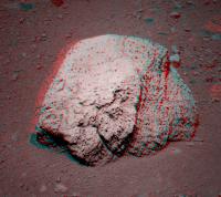
New pancams are down! I'm not even going to try to add them to The Panorama - I'll leave that to Ant and James! - but I would like to highlight a couple of rocks seen more clearly in the new images...
|
There's a "mini Wopmay" bottom left there, as Nick already pointed out, but this fella is pretty striking, don't you think..?

|
Posted by: Tesheiner Feb 1 2010, 12:08 PM
I thought that "your fella" was actually mini-Wopmay.
BTW, I checked the pancam web and it has been named "Mahanay Island".
Posted by: serpens Feb 1 2010, 12:38 PM
Looks like fracture fill. Makes sense that the bedrock would separate along a pre-existing fracture on impact.
Posted by: Egon Feb 1 2010, 12:59 PM
I agree.
Posted by: charborob Feb 1 2010, 02:35 PM
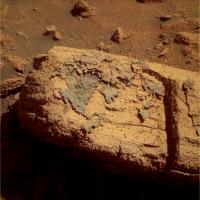
Stu, thanks for posting these images, especially the "little fella" (Mahanay Island is it?). This rock shows very well the degradation process in action on the Meridiani rocks. In a previous post, I was wondering why other (older) craters that we've seen weren't surrounded by rocks, like Conceptión is. The answer is right there. The rocks simply disintegrate away, like Phil mentioned. If this rock has only been exposed for 1000 - 10,000 years, imagine what would be left of it in a million years.
Posted by: Stu Feb 1 2010, 04:14 PM
Thanks charborob, I find this an interesting image too - look at the huge differences between the two largest rocks visible on it. The layered one on the left, that looks like rotten wood (but ISN'T!!!!! If any Woo Woo'ers are reading, that's a visual comparison, I'm not saying it's a tree, ok?!?!?!) looks so fragile and delicate you can imagine touching it and seeing it fall to pieces. The one on the right, another "mini-Wopmay", looks much denser and sturdier.

|
There will be some fascinating 3D views here soon, I'm sure...
Posted by: alan Feb 1 2010, 04:20 PM
Nice pile of blueberries around Mahanay Island, could be useful in making a more precise age estimate.
Posted by: Phil Stooke Feb 1 2010, 04:21 PM
Stu, I think the differences you mention are more about viewing the layers end-on or face-on. They look like similar rocks to me.
Phil
Posted by: Stu Feb 1 2010, 04:23 PM
You think? Hmm. They look quite different to me - the one on the left has none of that Wopmayesque crazy-paving surface structure.... You may be right. I'll look forward to a closer look.
Posted by: Phil Stooke Feb 1 2010, 04:47 PM
Right, but the one on the left turns its Wopmay face away from us. It's still probably as wrinkled as I am.
Phil
Posted by: belleraphon1 Feb 1 2010, 10:58 PM
OOOhhh Boy....
I think the rock hounds are gonna wanna stay here a while.
Craig
Posted by: fredk Feb 2 2010, 12:24 AM
They may get their wish. From the http://www.planetary.org/news/2010/0131_Mars_Exploration_Rovers_Update_Robots.html
Posted by: Zeke4ther Feb 2 2010, 01:59 AM
What I find intriguing is how we have sharp, clean shear faces on some rocks, and at the same time, very obvious erosion on the others.
Posted by: fredk Feb 2 2010, 03:39 AM
Amusing error in http://marsrovers.jpl.nasa.gov/spotlight/20100201a.html
Posted by: elakdawalla Feb 2 2010, 04:11 AM
I'm guessing the caption writer got a bit carried away from the starting point that Concepcion is probably the youngest crater that Oppy has visited.
Posted by: serpens Feb 2 2010, 04:42 AM
But the Planetary Society report attributes to Squires the comment that this is the freshest crater on Mars?
Posted by: fredk Feb 2 2010, 05:18 AM
Clearly a typo. Probably meant to say "This is by far the freshest crater we've visited yet on Mars..."
Posted by: MarkG Feb 2 2010, 05:20 AM
From this pancam picture...
http://qt.exploratorium.edu/mars/opportunity/pancam/2010-02-01/1P318252235EFFAB66P2369L2M1.JPG
...there is a real nice example of a fully-mineralized crack in a fragment of ejecta....

|
Posted by: Tesheiner Feb 2 2010, 09:18 AM
Next drive is planned for tomorrow, sol 2143.
Posted by: NW71 Feb 2 2010, 12:05 PM
Got a horrible feeling this is going to appear very naive but I'm going to post anyway...
Reading this thread there appears to be an assumption (which I'm sure is correct) that Concepcion cannot possibly be the youngest crater (at least of this size) on Mars. Do we know for sure that is the case? Can this be proved statistically or simply by the evidence in front of our eyes?
Statistically, I'd be very interested to know how regularly meteorites form such craters on Mars (and how this number compares to Earth)?
With our eyes, I'm assuming that we have pictures over the last 30 years of Mars showing new craters and therefore proving Concepcion is not the youngest?
Neil
Posted by: Phil Stooke Feb 2 2010, 12:23 PM
Absolutely right. We have before-after images of lots of craters forming in the last decade or so. This one, merely by virtue of its ejecta being so visible over the drifts, is the youngest seen so far by our rover.
Phil
Posted by: Oersted Feb 2 2010, 12:36 PM
And statistical evidence you say?
Well, I'd say that Opportunity is a rover which systematically demolishes every statistical presupposition... From it's "hole in one" touchdown, to all it did since then. So, statistics are out, and Oppy would probably also have landed right within roveable distance to the freshest crater on Mars if it could have...
Posted by: Hungry4info Feb 2 2010, 12:42 PM
NW71, MGS and MRO have imaged areas of Martian terrain multiple times, and on at least one occasion, a crater appeared in the later image that was not there in the earlier image.
http://hirise.lpl.arizona.edu/PSP_010200_1805
Posted by: djellison Feb 2 2010, 12:43 PM
And CTX has spotted over 100 new craters on Mars in our brief history of Martian exploration.
Posted by: NW71 Feb 2 2010, 02:16 PM
Thanks guys... I did say I might regret the naivety of that post... (walks off, slightly embarrassed)
Neil
Posted by: ElkGroveDan Feb 2 2010, 02:32 PM
MRO: http://www.nasa.gov/mission_pages/MRO/news/mro20090924.html
MGS MOC: http://www.msss.com/mars_images/moc/2006/12/06/craters/index.html
Posted by: Floyd Feb 2 2010, 03:31 PM
Neil--No problem asking questions. After a year or two of reading all the posts, you will be a space expert . Well at least you will read what the real space experts have to say. Welcome.
Posted by: fredk Feb 2 2010, 03:44 PM
No problem, Neil. I'm sure you weren't the only one out there.
And, Oersted's jesting aside, the odds of Oppy finding the youngest crater really are ridiculously low. Total Mars surface area is around 140 000 000 sq km. Area visited by Oppy is something like 20 km x 0.1 km = 2 sq km. Call it 100 sq km if you like. Then we've visited around one millionth of the surface. So the odds are one in a million that we'd stumble on the youngest crater. And even if we did, it wouldn't stay the youngest for long!
Posted by: BrianL Feb 2 2010, 04:16 PM
Let's hope that Concepcion doesn't become the youngest crater on Mars anytime in the near future.
Posted by: Phil Stooke Feb 2 2010, 04:30 PM
Should we rename the crater Misconcepcion?
Phil
Posted by: Stu Feb 2 2010, 04:34 PM
Don't worry, Neil, as they say, there are no stupid questions... Actually, that's not true; there are some VERY stupid questions, but you haven't asked any yet!
Posted by: ElkGroveDan Feb 2 2010, 05:06 PM
http://www.youtube.com/watch?v=7yl3UMO-TkE
Posted by: NW71 Feb 2 2010, 05:35 PM
Phil, that has to be an earlier contender for pun of the year (that is a competition I would not enjoy judging)!
Seriously, thank you (Stu, Dan, Doug, Fred, Oersted, Hungry4info, Floyd, Tesheiner etc) for the reassurance and the time you have all taken answering queries etc. I'm only just beginning to realise just how many factors and how many different directions this forum can go in... If you're ready to answer them I'm ready to keep asking them!
Until the next query...
Neil
Posted by: Den Feb 2 2010, 08:21 PM
It is not hard to infer that "this crater/rock is older than that one" by comparing which one is more weathered, but absolute age... IIUC now it is only tentatively known than Concepción is somewhere between 100 and 10000 years old, right?
What can be done by rovers in order to better constrain absolute ages of features on Mars? Come to think of it, I don't know how geologists do it on Earth either... These rovers can't do radioisotope dating, so what then can do?
Can APXS detect hydrogen/water? Can it be put into crater's dust covered center? In very young craters, ice may still very slowly sublimate from under surface, long after it looks covered by dry dust... OTOH, do we have detectable subsurface ice here, on the equator?
Posted by: marsophile Feb 2 2010, 09:32 PM
If we could find the impactor that created Concepcion crater, we might possibly be able to estimate how long it has been on Mars from APXS isotope measurements. Not sure if APXS can measure the relevant isotopes, but products of cosmic ray impacts while in space decay at a known rate after landfall on the surface.
Posted by: Sunspot Feb 3 2010, 01:13 AM
The layering in some of these rocks is stunning. !!
Posted by: nprev Feb 3 2010, 01:17 AM
I'm still stunned by Phil's pun...
Posted by: exoplanet Feb 3 2010, 02:29 AM
I think what is really and truly interesting in these rocks are the status of the blueberries. From what I have read from previous posts is that it would take "millions" of years for the blueberries to fall out of the "muffin" rocks. Here we are seeing this in 1000's of years.
Posted by: exoplanet Feb 3 2010, 02:57 AM
Before I sign off for the night I would like to put my thoughts down on this crater. The previous "hypothesis" of how the blueberries are eroding out of the bedrock just does not make sense if this crater is so young. The rock faces should not only be razor sharp but the blueberries should be broken in many cases (not all) along the fractures of the bedrock due to the impact. This is not what we are seeing here. Either this crater is much older than what has been stated (in this case - move on to Endurance ASAP as there is no real science here) or the blueberries are not concretions but something else.
I am sorry but the blueberries along the route to Endurance have stayed the same size for many kilometers. If these are truly concretions we should be seeing the size of the blueberries differ by great amounts over this distance. I hope Juramike is reading this thread - I would love to hear his take on this.
Posted by: fredk Feb 3 2010, 03:01 AM
Here's what may be one reason to stick around. I've noticed a couple of cobbles that stand out recently. Here's a good example: it's much smoother than the meridiani pavement ejecta, and also much darker in L2:

|
Could this be a piece of the impactor?
Posted by: ups Feb 3 2010, 03:14 AM
Phil
hee hee http://www.youtube.com/watch?v=K8E_zMLCRNg
Posted by: Phil Stooke Feb 3 2010, 03:41 AM
"Should we rename the crater Misconcepcion?"
Wow, that went over quite well. I must be witty more often.
Phil
Posted by: nprev Feb 3 2010, 03:44 AM
Well, the first time's always a charm... 
Posted by: Stu Feb 3 2010, 08:24 AM
Very interesting sighting, Fred! I believe today is a driving day, so we can all play "Spot the Impactor"!
(Any we find, Nick gets to keep as birthday presents - happy birthday Nick! )
Posted by: Tesheiner Feb 3 2010, 09:02 AM
Yes it was.
There are still no images on the exploratorium (another bottleneck in the pipeline?) but from the available data it was something like a few meters back over the tracks and then 5m east. Is there any interesting rock on that area?
(Happy birthday Nick!)
Posted by: Stu Feb 3 2010, 11:03 AM
Nice view now...

|
Posted by: Stu Feb 3 2010, 11:25 AM
Your rock is very interesting in a colour view, Fred...

|
... but I'm always amazed by the sight of rock 'towers' like these...

|
Posted by: djellison Feb 3 2010, 11:44 AM
When you rip a muffin into two pieces, do the blueberries in THAT split? What about a chocolate bar with nuts in it?
When a rock breaks apart, it'll do so in the easiest way possible - leaving the berries intact.
Despite that - there are some cases of split-berries around - we've seen them - so it happens very rarely, but it does happen.
Posted by: Stu Feb 3 2010, 12:21 PM
Couple more pics in a new post over on my blog: http://roadtoendeavour.wordpress.com/?p=349
Posted by: nprev Feb 3 2010, 01:12 PM
)Awesome...thanks, Stu! Gonna go pick those suckers up after work...
Posted by: exoplanet Feb 3 2010, 02:26 PM
Doug,
I can see your analogy but I politely disagree . . . These rocks were not gently broken apart like you would a muffin - they were blasted out of the ground relatively recently.
Due to this craters young age - we should be seeing something different here.
Posted by: algorimancer Feb 3 2010, 02:32 PM
Nevertheless, hematite is VERY hard, and sandstone correspondingly soft (commonly it will crumble in your hands), so it appears to me that what we are seeing is not inconsistent with a very recent impact. Probably only immediately adjacent to the impactor itself would the shock have been high enough to shatter blueberries, and I would expect that when the shock is that high the sandstone in which they were embedded would have been turned to sand.
Posted by: fredk Feb 3 2010, 03:04 PM
I love those towers too, Stu!
So it looks like we've been positioned to approach the rim again, but between rays.
Posted by: hendric Feb 3 2010, 05:09 PM
Exo,
I think the misconception is that the crater is 1000 yrs old, +- X%. It's not, according to Emily's blog. It's more like the crater is 1e4 yrs old, +- a couple factors of ten, ie 10-100,000 yrs old. That would give sufficient time for any "boundary berries" to have eroded out.
Posted by: Joffan Feb 3 2010, 06:15 PM
I would expect the amount of "fast break" rock to be tiny compared to the "slow break" rock. During the cratering event, the surface rock will keep getting broken and displaced until the energy transmitted is too low. The energy spread should mean that most of the affected rock was broken by energies only a little way above the rock-breaking threshold.
Here's my understanding of the process: the impactor arrives at a point on the surface, travelling at more than the speed of sound in rock, massively compresses itself and the immediate impact surface with local fast-break shear and shock waves, then the subsequent violent decompression disperses spherically at the speed of sound creating a slow-break explosion which is responsible for most of the rubble.
A cross-section simulation video on crater formation would be fascinating - I'm sure there's a good one out there somwhere.
Corrections from people who actually know the crater formation process (rather than my approximation) would be most welcome.
Posted by: fredk Feb 3 2010, 06:38 PM
I guess you meant 10^3. Emily's post said it was older than the bright rayed 10^1 yr old craters, and younger than the estimated 10^5 yrs ago that the dunes last moved. So they interpolated logarithmically to get 10^3. But you're right that it really should be 10^(3+/-2) yrs.
But I wonder if we can do better, now that we've got the ground view. There must be some thinking about the erosion rate of meridiani sandstone due to wind. If there was some way to estimate how much these ejecta blocks have eroded since the crater formed (degree of roundedness of originally sharp corners? gaps between blocks that had been adjacent in the ground??), then we could get another estimate of the age of Concepcion. Or is the erosion rate very uncertain?
Posted by: MarkG Feb 3 2010, 06:45 PM
In guessing the age of Concepcion (and developing a geomorphic age scale for Meridiani craters), one must keep in mind the non-linearity of processes at work here. Dune migration has already been shown to be likely episodic.
Another type of phenomenon not yet discussed is the de-hydration of once-buried debris. If there is any residual moisture or hydration in the excavated rocks, it will be exposed to wider temperature and lower effective pressure, and will rapidly evaporate, perhaps causing shrinkage as well (look at the tiny cracks on mini-Wopmay). This erosion may occur rapidly in even a few days (or seasons), and then tail off. But it would generate a lot of deterioration of the excavated debris relatively quickly, and then things would slow down.
The result of this may be big error bars in certain age ranges in our Meridiani crater-dating scale.
Posted by: elakdawalla Feb 3 2010, 06:45 PM
There's an awful lot of arm-wavey geology going on in this thread -- I think if you guys are really that interested in this stuff, you need to go and do some reading in the literature to see what planetary geologists have come up with based upon the many decades of work that's been done in the fields of impact cratering, age dating, and so on. LPSC abstracts are a very good place to start because they're free to download and are two pages long -- neither overwhelmingly long nor too brief -- with the caveat that they are not peer-reviewed. It's fine to speculate about what it is that you're seeing, but I think it doesn't make a lot of sense to actually sit around and argue interpretations until you inform your arguments a little bit more. Do http://lpsc%20site:www.lpi.usra.edu and follow links to the Program with Abstracts for each, you'll find lots of stuff to read. If you find something good to inform the discussions on this thread, post a link here. Googling individual authors whose LPSC abstracts indicate they do a lot of work in this field may lead you to personal websites where they post PDF copies of their published papers.
Posted by: helvick Feb 3 2010, 08:03 PM
The fact that the rocks here are clearly substantially eroded while the consensus is that Concepción is relatively young merely adds another useful datapoint with which to refine overall crater ages. The assumption that it is 10^3 +- a couple-of-orders-of-magnitude in age is still only an informed estimate based on a lot assumptions (relatively static weathering over the time frame, an estimate that dune formation is on the order of 100k years (IIRC), etc). If the ground truth evidence means that Concepción must be at least 100k years old (for example) then we need to re-examine the other assumptions, in cases like this at any rate.
The blueberries haven't been consistent in size over the whole trip - there is substantial variation. The fact that they are the same here as they were in other areas only tells us that the conditions that formed them here and in those other areas were quite similar. The fact that all blueberries are generally fairly uniform in size (in one area) and all have been below x-size (so far) provides useful data points too but all it really means is that we can rule out many processes that would produce wider variations in size over small areas and processes that would lead to very large concretions.
The difference in hardness between the "sandstone" of the meridiani rocks and the hematite spherules is very large - the analogy with cracking open a blueberry muffin is not really a good analogy (sorry Doug) because (organic) blueberries and muffins are not that dissimilar in texture\hardness. This stuff is like flint nodules in chalk, and even then the chalk is too probably too hard. It's very hard to break flint nodules embedded in chalk when you hit the chalk.
Posted by: Adonis Feb 3 2010, 09:10 PM
I have some doubt related with crater's age estimation that I'd like to address, since I don't known if I could be right in something or wrong at all.
In the 6 years we have Opportunity in Mars we could have a close estimation of the of annual ammount of sand which falls into the martian soil from the atmosfere, due to the duststorms or suspension sand. This can be done from the visual appearance of the MER solar panels we have among those years from the cam images. Let's say this rate to be 0,1 mm per year (only a rough guess, maybe far from actual value I don't have, but suppose can be calculated with some accuracy). This dust is also, along the craters age, deposited in the craters floor, so craters in Mars gets filled with sand and their depth are, with time, been reduced. With that guessed rate (it's only an example), craters floor would be filled with 1 meter of sand every 10.000 years.
If we have the ratio of crater diameter versus crater depth for a new crater (something that I thing can also be done within a degree of accuracy), we can have a way to calculate craters age from the measured crater depth. Of course, some factor should be taken into account, due to the action of martian wind which both, gets sand into and send out sand from the crater. So, my question is ¿this method can be accurate enougth to calculate crater ages to some accuracy?
Thanks
Posted by: centsworth_II Feb 3 2010, 09:36 PM
(Non-expert opinion
)Posted by: Den Feb 3 2010, 09:38 PM
Dust isn't only deposited - it is also blown off
Posted by: BrianL Feb 3 2010, 09:40 PM
Surely you jest, Emily. Millions of debates are settled each day not on facts, but on who can better argue their position. It's called our legal system.
Posted by: centsworth_II Feb 3 2010, 10:06 PM
Of course scientific interpretation is an entirely different matter from legal interpretation.
Posted by: ngunn Feb 3 2010, 10:51 PM
But if the expert witnesses turn up with an estimate that has an uncertainty of two orders of magnitude then somebody has to step in and adjudicate.
Posted by: Adonis Feb 3 2010, 10:54 PM
I think you're correct,... and dust is also blown into (maybe more than blown off, because a crater acts like a hole in the soil). In any case, it's evident that older craters are more dust filled than newer ones. There are plenty of ancient dust filled craters almost completely filled, which rims are almost unrecognizable. Maybe it's complex to determine an approximate relationship of crater age from crater diameter and depth, but I suppose that's because it's not a trivial relationship, but I think it's evident that it exists. At least, this could be a method for chronological ordering crater ages in a same martian regional area, where sand and dust behavior are the sam in all their craters.
Posted by: ngunn Feb 3 2010, 11:21 PM
It may not even be a monotonic relationship. A crater could fill up and get cleaned out again over and over, on long timescales. Same with drifts and dunes. They may move rapidly in some epochs, hardly at all in others, and the active epochs could be out of phase at different locations on Mars. It's not that easy to find a reliable clock on any world. (Ask the archaeologists.)
Posted by: mhoward Feb 4 2010, 02:44 PM
http://www.flickr.com/photos/marscat/4329659891/sizes/o/
Sol 2143 view with the model at sol 2138 .The false-color Pancam image was labelled "Loboc River".
Posted by: Stu Feb 4 2010, 03:31 PM
Some very interesting features on that rock, and the one to its right...
|
|
Posted by: Juramike Feb 4 2010, 03:40 PM
Cool!
I wonder when those fracture patterns set up on that central block. Pre-impact or post-impact?
Posted by: machi Feb 4 2010, 03:58 PM
Interesting quasicircular feature on square-shaped rock.
Posted by: Stu Feb 4 2010, 04:21 PM
Mahanay Island's a bit rough, isn't it?
|
Posted by: Beauford Feb 4 2010, 08:33 PM
Mahanay Island's a bit rough, isn't it?
Is that a ring of blueberries around the base? If so, I wonder if some scholarly soul with a knowledge of the weathering rate could put this scene to good use.
Posted by: kenny Feb 4 2010, 10:39 PM
|
|
For me, the undercutting erosion of features like this blows away the idea that Concepcion is a mere 1000 years old. It must be much older, surely... with the caveat that I have not yet done the homework advised by Emily.
Posted by: Tesheiner Feb 5 2010, 08:33 AM
The Concepción was burned on the island of Bohol, that's one cool name isn't it?...And the island as its own nice places...like Chocolate Hills...
Just got word from our beloved MC, the suggestion was approved, a Mars bar anyone?
This is from tosol's plan:
> 02145::p2556::24::4::0::0::4::2::10::pancam_Chocolate_Hills_L257R1
Enjoy it.

Posted by: Stu Feb 5 2010, 08:38 AM
Chocolate Hills... you couldn't make it up, could you?
Posted by: Tesheiner Feb 5 2010, 09:08 AM
And here's an autostitched mosaic of http://qt.exploratorium.edu/mars/opportunity/navcam/2010-02-05/.
|
|
This is Chocolate Hills. Original picture here: http://qt.exploratorium.edu/mars/opportunity/pancam/2010-02-05/1P318612743EFFABC0P2556L2M1.JPG

|
Posted by: Stu Feb 5 2010, 09:34 AM
Colour of Chocolate Hills (missing area at top, grrrr)

|
Posted by: ustrax Feb 5 2010, 09:52 AM
writing with my mouth full...
...and those are some tasty images you got there Stu!
Posted by: Stu Feb 5 2010, 10:32 AM
More images in a new post on my blog, along with some background info on Bohol Island, which some of you might find interesting...
http://roadtoendeavour.wordpress.com/2010/02/05/oppy-reaches-the-chocolate-hills
Posted by: Juramike Feb 5 2010, 01:23 PM
Contrast-adjusted crop of the Chocolate Hills to enhance the cracks and fissures. Filtered images 2 and 5 were combined and heavily played with:

|
Details and full res version here: http://www.flickr.com/photos/31678681@N07/4331802075/
The blueberries on their stems are funky!
Posted by: Stu Feb 5 2010, 01:46 PM
Yep, they are!
http://twitpic.com/11hoqt/full
Posted by: Juramike Feb 5 2010, 03:27 PM
I *think* that might be telling something about the ages of the ejected blocks.
Noway those structures could've pre-existed prior to impact. Blocks got ejected. Failure along regions of surface "defects", putting blueberries at the crack margins. Then slow sand ablation leaves the blueberries at the end of stalks. In 10E(quoi?) years the stems will fail, and the blueberries will drop, and the stems will get ablated down to the rock surface.
So given an average blueberry diameter of 4 mm. Those stalks are about another 4 mm. Assuming the blueberries started with the tips flush at the crack margin, there has been 8 mm of erosion since block emplacement.
Posted by: SteveM Feb 5 2010, 04:00 PM
Yes, but it looks like a complicated problem, since the blueberrys on stalks (at least the ones that we can see) are in the niches that are comparatively sheltered from the erosive action of the wind.
Steve M
Posted by: Ant103 Feb 5 2010, 04:24 PM
Sol 2145 navcam pan
http://www.db-prods.net/marsroversimages/Opportunity/2010/Sol2145-pano.jpg
Posted by: fredk Feb 5 2010, 08:14 PM
Those Chocolate Hills sure do look tasty...
The http://marsrovers.jpl.nasa.gov/mission/status_opportunityAll.html#sol2137 said we're approaching some ejecta blocks to possibly use the IDD on - perhaps Chocolate Hills?
The update also had this little tidbit:
Posted by: Stu Feb 6 2010, 11:12 AM
My 'pan so far' of Concepcion...
http://twitpic.com/11nwh2/full
LOoking forward to seeing the proper versions here soon!
Posted by: NW71 Feb 6 2010, 11:19 PM
At the risk of inviting more of the 'arm-wavey geology' highlighted by Emily what would be the underlying story with the twin craters? Would I be right in thinking it would be a meteorite that split into two on its descent through the martian atmosphere?
(I think this should be in the distant vistas thread - can someone help please!)
Neil
Posted by: Phil Stooke Feb 7 2010, 12:14 AM
Consider all the possibilities:
- two separate impacts, a pure coincidence
- a meteorite that split in two
- two ejecta blocks from a distant crater, or one that split in two (i.e. these are secondary craters)
Nothing we have now could distinguish between these possibilities. One rule for arm-waving is not to stop with the first idea that comes along, but to look at all the other possibilities as well. Multiple working hypotheses! Then we can try to weed out the weaker suggestions with observations or other approaches.
Phil
Posted by: Stu Feb 7 2010, 10:56 AM
Oh wow... the Chocolate Hills are turning out to be quite fantastic 3D targets...

|

|
Looking forward to more colour views of these rocks.
Posted by: akuo Feb 7 2010, 12:58 PM
I don't usually do this kind of thing, but...
Does anyone else think Oppy has found her companion?

|
Posted by: Ant103 Feb 7 2010, 01:34 PM
So, updated version of the Sol 2140 color pan of Concepcion. We can now see it entierely :
http://www.db-prods.net/marsroversimages/opportunity-2010.html#concepcion
(I prefer to link to my page because the direct link to the full version will lead to load a 4.4 Mo pic).
Posted by: Stu Feb 7 2010, 10:21 PM
Ooooohhhh.... Easily one of my most favourite 3D views yet...
|
... and straightened out a bit...
|
Posted by: nprev Feb 8 2010, 12:43 AM
Garg!!! What can I say, what can anyone say: damn cool is all, Stu, wow! What an amazing rock, and your 3Ds always kick ass; well done!!!
Posted by: climber Feb 8 2010, 11:30 AM
|
|
The shapes on this (left) rock look like an ancien map of the (Mars) world, don't you think?
Posted by: Tesheiner Feb 8 2010, 11:53 AM
So it wasn't just me.
I saw a shape similar to north and central america on it.
Posted by: climber Feb 8 2010, 01:59 PM
Very much so.
Please do NOT let Rui play with this rock/map
Posted by: Stu Feb 9 2010, 09:09 AM
Wow...
|
Discuss!
Posted by: antoniseb Feb 9 2010, 09:55 AM
It's not such a fresh crater after-all, the protective coating is wearing off the debris.
Posted by: Phil Stooke Feb 9 2010, 12:06 PM
A mechanically weak layered deposit, originally formed in a fracture, is falling apart now it's exposed to the surface environment. Age can't be determined from the appearance of the rock if we don't know its strength.
Phil
Posted by: Stu Feb 9 2010, 02:34 PM
Some more colour and 3D views on my blog, here:
http://roadtoendeavour.wordpress.com/2010/02/09/colourful-chocolate-hills
Posted by: Marz Feb 9 2010, 02:49 PM
It looks as if a congregation of berries became cemented into the rind, almost like a clast? The upper portion looks as if large crystals formed, perhaps hinting at how long this vein formed under solution?
Posted by: eoincampbell Feb 9 2010, 03:01 PM
Could this be the "impact melt" the team referred to ?
Posted by: fredk Feb 9 2010, 03:15 PM
They mentioned a dark crust that was potentially impact melt. I'm sure this is what they were referring to - the only other rock crusts around look very similar to this.
Do these closeups provide any hints about whether this is a filled fracture or impact melt? Obviously the IDD work will be important...
Posted by: Ant103 Feb 9 2010, 04:05 PM
Stu, I think I can see North-Am... ahem... nevermind
Oh ! And I also see ... *please Ant, shut up !* :/
Hum
So, the Sol 2147 pan, with Chocolate Hills at the "wheels" of Oppy
http://www.db-prods.net/marsroversimages/Opportunity/2010/Sol2147-pano.jpg
Posted by: Phil Stooke Feb 9 2010, 04:07 PM
The multi-layered appearance would argue strongly against impact melt, but more seriously still, this is on a bit of Meridiani sandstone, not an exotic rock. Evaporitic deposits in a vein - an old fracture - make far more sense, especially since we've been seeing these vein-filling materials ever since Eagle crater.
Phil
Posted by: climber Feb 9 2010, 04:08 PM
Gentlemen, I think Stu means "Discuss of the shape of the coating that looks like an ancient map of Mars" (see previous posts)...but I might be wrong
Posted by: vikingmars Feb 9 2010, 04:48 PM
Well, it rather looks like a prediction sent by Martians for our future : the Earth as seen AFTER a global sea level rise by global warming (America is at left and what's left of Europe on the right...)

|
Posted by: Hungry4info Feb 9 2010, 05:20 PM
That was such a cute game xD.
And yeah, I think we'll stay here a bit. This rock seems to be crying out for attention.
Posted by: Phil Stooke Feb 9 2010, 07:19 PM
Here's Ant's latest pan in a circular format.
Phil

|
Posted by: Greg Hullender Feb 10 2010, 02:21 AM
I still haven't forgotten the high-speed turtle.
--Greg
Posted by: Stu Feb 10 2010, 03:44 PM
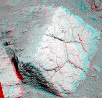
Okay, who wants first crack at this beautiful rock with their geology hammer and field magnifying lens..?

|
Posted by: Juramike Feb 10 2010, 04:02 PM
A gentle whack and then turn through the pages of time.
I really like the way that the fissures on the sides stop at some of the layering. Those layers are just waiting to be pried apart with a chisel.
Posted by: leustek Feb 10 2010, 04:23 PM
Quote Stu - Okay, who wants first crack at this beautiful rock with their geology hammer and field magnifying lens..?
Mud cracks?
the Earthly kind http://www.earthscienceworld.org/images/search/results.html?Keyword=Mud%20Cracks#null
Posted by: Nirgal Feb 10 2010, 05:00 PM
First MI images are up at exploratoium ...
here is a very quick try of a 3D shape-from-shading DEM ... unoptimized and uncalibrated as I havn't used the method for MI/rock images before.
Not sure if this could be of any use geologically (*), I was just curious what it would look like :-)

|
(*) probably more for entertainment: something like a fly-through video over MI rock images
Posted by: djellison Feb 10 2010, 05:12 PM
Try comparing the technique to results in here - http://an.rsl.wustl.edu/mer/merbrowser/mergedfocal.aspx?rover=2 - to see how accurate it is.
Posted by: Stu Feb 10 2010, 06:44 PM
Rather like this view... Oppy getting ready to get down to work!

|
Lots more pics on my blog, if anyone would like a look...
http://roadtoendeavour.wordpress.com/2010/02/10/oppy-takes-a-closer-look-at-concepcions-chocolate-chunks
Posted by: dburt Feb 10 2010, 07:06 PM
Or more properly, shrinkage cracks (of which mud cracks are probably the best-known terrestrial example). They can occur in many different rock types that have undergone bulk shrinkage owing to drying, cooling, or weathering (with leaching). They also occur in concrete.
-- HDP Don
Posted by: fredk Feb 11 2010, 12:00 AM
The MI's are targetting a part of the "rind" (whatever it is). Here's the portion covered so far, roughly outlined in black on Stu's fabulous colour view:

|
Basically, this gives us a closeup view of the western Canada portion of "North America". Excellent place to start.
On the other hand, according to this Martian map, it looks like a big chunk of western Canada/US is missing and presumably has slipped into the Pacific.
 Another "prediction"?
Posted by: nprev Feb 11 2010, 12:22 AM
Hey, Fred, this is a highly impertinent request, but any chance you could throw a couple of your famous Shadow Men around Concepcion? That sense of scale you provide is a great thing. (But no pressure if you got things to do, man; I can definitely relate!)
Posted by: Phil Stooke Feb 11 2010, 12:48 AM
"it looks like a big chunk of western Canada/US is missing "
It's the old 'Mer de L'ouest'. Must have been the old Admiral's inspiration.
Phil
Posted by: Stu Feb 11 2010, 04:38 PM
Mosaic of some new MIs...
|
Posted by: eoincampbell Feb 11 2010, 05:18 PM
Wow, the blueberries seem to be really concentrated though still embedded... a heavier cluster than any berry bowl we've seen ?
Posted by: Stu Feb 11 2010, 06:03 PM
Easy to imagine actually standing there, next to these rocks, when you see a view like this...

|
Posted by: MarkG Feb 11 2010, 06:18 PM
...The anatomy of a crack, and a very dirty one. Likely a result of dessication shrinkage and debris (mostly blueberries, plus general Martian dust) filling, with evidence of multiple episodes of some sort of degree of re-hydration cementing things a bit.
We see again how the passage of time preferentially concentrates the hematite nodules while the sulfur-salt-sandstone matrix is powdered and blown away.
The extreme friability and tiny particle size of debris powder of the Meridiani substrate create some interesting questions. We have seen dunes of the sulfur-salt stuff only on places like the rim of Victoria, where the rate of production and concentration of the sulfur-salt powder is relatively prodigious. Where does it go? Some ideas...
1) The Meridiani hematitie/sulfur-salt plains occur only on a small percentage of the surface of Mars. Its eroded dust thus becomes just a trace constituent of the general Martian dust. It is just diluted to near-invisibility.
2) The sulfur-salt dust could be a preferred nucleation site for precipitation. Snow nucleus. This would systematically remove it from the global dust inventory over time.
3) There could be some sort of very slow chemistry going on between these sulfur salts and the Martian atmosphere. This might also influence how it erodes. It could be driven by some trace atmospheric constituent or even solar/cosmic radiation side effects.
Anyhow, these are some thoughts that the Concepcion MI's have brought to mind. I don't have good access to journals (I do read articles I find out about, by the way) or daily bull sessions with grad students, or full access to all the results of the instrumentation, so maybe this has been covered already. This forum is my scientific coffee break, about all I have time for. I hope the working scientists don't take offense, and will be glad for the display of interest in the details of their work, and forgive the speculations-based-on-inadequate-data that come out of this forum.
Posted by: Tman Feb 11 2010, 06:21 PM
yummy...baked blueberries?
Posted by: Stu Feb 11 2010, 09:52 PM
Introducing the new "Chocolate Hills" bar... crammed full of tasty berries and covered in a delicious, dark crunchy coating...
|
Posted by: fredk Feb 11 2010, 10:46 PM
Rightmost block of Chocolate Hills as pancam anaglyph:
|
Nprev, with some luck I may be able to coerce the Mystery Men to come out of hiding - they're remarkably shy, but all this talk of chocolate may help...
Posted by: ngunn Feb 11 2010, 10:52 PM
I love the way the random polygons on that rock fit themselves into a square. It reminds me of this:
http://images.google.co.uk/imgres?imgurl=http://2modern.blogs.com/photos/uncategorized/2008/02/15/watercube3.jpg&imgrefurl=http://2modern.blogs.com/2modern/2008/02/bubble-wrapped.html&usg=__jplZ1rG2KMT9OSAA9QQuhMPPw5c=&h=333&w=500&sz=57&hl=en&start=39&um=1&itbs=1&tbnid=EJKbjOHyruLFDM:&tbnh=87&tbnw=130&prev=/images%3Fq%3DBeijing%2Bwater%2Bcube%26ndsp%3D18%26hl%3Den%26client%3Dfirefox-a%26rls%3Dorg.mozilla:en-GB:official%26hs%3DTiN%26sa%3DN%26start%3D36%26um%3D1
Posted by: Shaka Feb 12 2010, 12:29 AM
Hmmm....verrrry interesting.
Is this the first time we have seen blueberries so tightly packed within a lithifying (?) matrix? Most of the laminated sandstone around here has the concretions well and evenly spaced, as in the usual pattern of their in situ formation. I assume they cannot form in such a closely-packed pattern, so we must infer that they were eroded out of the laminated sandstone, collected together in a crack between blocks and then re-cemented by later fluid invasion of the crack. Is this final step a rare and localized event, such that we have not seen before on Meridiani? Does this region have an unusually lengthened diagenetic history? One which points to a wet period following blueberry formation and excavation? Some areas of the exposure seem to show where blueberries have fallen out, leaving an "egg-carton" like pattern in the matrix. Blueberries excavated for the second time in their 'lives'! How long was this part of Meridiani wet?
Always something new.
EDIT: Or could the local impact have played a role? C'mon, Don, are you taking the plunge?
Posted by: centsworth_II Feb 12 2010, 12:56 AM
If those are remnants of a fracture fill on the surface of the rock, maybe it was a fracture filled with loose berries which were then lithified by the fill material.
Posted by: Shaka Feb 12 2010, 01:55 AM
I'd say that's the most parsimonious explanation, $.02, (Don might disagree), but then why haven't we seen it before?
Could the crater here provide a more localized, recent mechanism to 'cement' the concretions?
Posted by: fredk Feb 12 2010, 02:52 AM
In the http://marsrovers.jpl.nasa.gov/mission/status_opportunityAll.html#sol2145, they still refer to impact melt:
Posted by: dburt Feb 12 2010, 04:34 AM
...How long was this part of Meridiani wet?
...Or could the local impact have played a role? C'mon, Don, are you taking the plunge?
I'd hesitate to rule out a role for impact being so close to the little crater, but probably not, other than excavation. "Wet" is a relative term, so a possible working hypothesis might involve the role of soluble salts plus fallen dust plus transient moisture/frost in creating a cement to hold the fallen berries together within an initially open fracture, before impact exposed the sample. That potentially gives us billions of years of daily and seasonal and epochal climate change to call upon to cement the berries, without having to call upon flowing or standing water, other than transient surface films. (Or impact; sorry, I didn't even stick my little toe in...)
Just an initial working hypothesis, of course. One possibility among many, including impact melting, especially given that moist salt mixtures must have quite low melting temperatures (i.e., be very easy to fuse into a cement). On the other side, if the rock were exposed to enough impact stress to fuse the salts, how on Mars did all the brittle berries survive intact? So I'd tentatively rule out impact.
I'd tentatively rule out large quantities of liquid water too, because everything remains so fine-grained. If salty water were standing or flowing in that crack for any length of time, we might expect to see visible salt crystals (or their ghostly imprints) lining it, or perhaps solution/recrystallization damage (i.e., disaggregation) or other visible alteration affecting the salty rock next to the crack. (Where salts are concerned, liquid water is powerful stuff!) Such evidence appears to be lacking.
That seems to leave a crack filled with fallen berries and salty dust and frost and transient moisture and time as the least unattractive hypothesis for cementation. So boring!!
--HDP Don
Posted by: centsworth_II Feb 12 2010, 05:00 AM
It seems a bit of a knife edge to define an impact that would leave such a small crater and melt the surface of fragile sulfate ejecta blocks while leaving them intact, and not throwing them very far.
Posted by: Shaka Feb 12 2010, 05:17 AM
AHAAA! The penny drops...
The dollar drops...
The euro rises...
The moon is blue and Prof Don favors moist chemistry, whereas JPL favors "impact melt".
...anyway, Shall we then follow our JPL PI's and view the 'matrix' as the product of molten or vaporized impact material injected under high pressure into cracks in the bedrock, engulfing and entombing the berries within? Why haven't we seen it around any of the other craters we have surveyed? Is it a very short-lived material like a glass, which breaks down quickly ( i.e. in thousands rather than millions of years)? Should it have an exotic - partly extraterrestrial (Mars equivalent) - composition, which we can detect with the IDD? Can we see any other signs of this violent history? On the other hand, this IS a crater and there must be some violence involved!
Is Mars boring? Noooooo!
Posted by: fredk Feb 12 2010, 05:21 AM
We have seen similar looking "rinds" before. IIRC, at Erebus, but also inside Victoria, eg check out http://www.unmannedspaceflight.com/index.php?s=&showtopic=4570&view=findpost&p=110873 I'm sure others can recall other locations.
Posted by: Shaka Feb 12 2010, 05:30 AM
Rinds, yes, but matrices packed solid with blueberries?
(image links requested)
Posted by: brellis Feb 12 2010, 06:54 AM
For every thousand times I wanna ask a question here, I keep mum 947 of 'em. This time I gotta ask one simple (set of ) Qs(hehe):
Have we come across an impact crater that shows an object hit a wet surface? We have hints of subsurface water ice from Phoenix, and from the deposits dug up by Spirit; do we have any similar hints from something like the blueberries or other facts gleaned from the rovers' studies of craters and ejecta thus far that establish an object "splashed down" on Mars?
Could Endeavour crater give us such tantalizing hints? Did Endeavour crater occur while Mars was wet enough to prove in a new way that there was surface water? Or, have we already established that scenario from other data?
Thanks, and again, I really love this site!
Posted by: CosmicRocker Feb 12 2010, 07:05 AM
I thought I might have seen a glimpse of what you are talking about as I flipped through some of the recent MIs, but then I realized it was a case of inverted topography. MI imagery can sometimes trick your brain since the images are inverted. Note that the shadows imply a sun shining from the bottom upwards.
Yes, we've seen many examples of these rinds before, as Phil previously noted. But I am pretty sure we never saw a rind containing closely packed concretions as we observe them here. It seems easy to imagine eroded berries falling into a dessication crack and eventually becoming cemented by some fracture filling, if some water is available in some form. Dr. Burt makes a good point regarding the grain size of recrystallized salts.
I've been trying to imagine an impact process that could release concretions from the matrix and then allow them to concentrate in a bedrock fracture. If the impact generated enough energy to melt or vaporize sulphates, it seems that most of the released blueberries would be blown out of the fractures. However, I can imagine some berries getting concentrated at flow path choke points.
Posted by: Den Feb 12 2010, 06:03 PM
I guess we did. There are numerous indications Mars was wet.
(1) Mars loses water faster than Earth - its gravity is ~3 times weaker, and it has no strong magnetic field to keep solar wind away. Yet, it _still_ has a lot of water (as ice). This means that it had to have much more water in the past than it does now. More water -> more water vapor -> stronger greenhouse effect.
(2) Primordially, it had to have much more water per unit of mass than Earth had just because it formed in colder region of proto-Solar system.
(3) We have solid evidence of minerals and landforms which can form _only_ in liquid water.
Posted by: brellis Feb 12 2010, 06:37 PM
Thanks for the response, Den. What you're suggesting is that we've proven Mars was once wet on the surface. Theory has it that Mars dried up to basically its current state billions of years ago, and all these craters we're seeing are from collisions that happened after it dried up. I'm wondering if we have a chance to find evidence that one of these big old craters splashed - not crashed - to the surface.
Wouldn't there be a different signature in the ejecta if an asteroid splashed down on a Martian lake/ocean, instead of crashing into a dried up lake bed?
Oppy didn't make it all the way to the bottom of Victoria crater; did we learn all we needed to learn by going 1/3 of the way down? Was Victoria a lake at one point?
When the object that created Victoria crater struck Mars, was there surface or subsurface liquid water (not ice)?
I guess an obvious place to look would be Gusev crater, which became a huge lake bed before Mars dried up. That object crashed or splashed into a wetter Mars.
Posted by: elakdawalla Feb 12 2010, 06:42 PM
Do http://adsabs.harvard.edu/cgi-bin/nph-abs_connect?db_key=AST&db_key=PRE&qform=AST&arxiv_sel=astro-ph&arxiv_sel=cond-mat&arxiv_sel=cs&arxiv_sel=gr-qc&arxiv_sel=hep-ex&arxiv_sel=hep-lat&arxiv_sel=hep-ph&arxiv_sel=hep-th&arxiv_sel=math&arxiv_sel=math-ph&arxiv_sel=nlin&arxiv_sel=nucl-ex&arxiv_sel=nucl-th&arxiv_sel=physics&arxiv_sel=quant-ph&arxiv_sel=q-bio&sim_query=YES&ned_query=YES&adsobj_query=YES&aut_logic=OR&obj_logic=OR&author=&object=&start_mon=&start_year=&end_mon=&end_year=&ttl_req=YES&ttl_logic=AND&title=rampart+craters&txt_logic=OR&text=&nr_to_return=200&start_nr=1&jou_pick=ALL&ref_stems=&data_and=ALL&group_and=ALL&start_entry_day=&start_entry_mon=&start_entry_year=&end_entry_day=&end_entry_mon=&end_entry_year=&min_score=&sort=SCORE&data_type=SHORT&aut_syn=YES&ttl_syn=YES&txt_syn=YES&aut_wt=1.0&obj_wt=1.0&ttl_wt=0.3&txt_wt=3.0&aut_wgt=YES&obj_wgt=YES&ttl_wgt=YES&txt_wgt=YES&ttl_sco=YES&txt_sco=YES&version=1 -- these things have splashy-looking ejecta that most scientists think are the result of ejecta being entrained in mobilized groundwater (produced from ground ice melted by the impact), while others (mostly Pete Schultz) say you can explain them with atmospheric effects.
Posted by: Stu Feb 12 2010, 06:54 PM
You want layers? We've got your layers right here...

|
Posted by: Phil Stooke Feb 12 2010, 07:22 PM
I wouldn't say Mars dried up, it froze. It looks dry because it's so cold but it's actually got lots of water.
Rinds - the first I think was in Eagle, and was called shark or something like that. Over near the Berry Bowl.
And we haven't seen this specific thing before because we never saw one of these filled fractures in the open before - they were just protruding from the eroding rock.
Phil
Posted by: nprev Feb 12 2010, 08:38 PM
That's stunning, Stu!
Posted by: dburt Feb 12 2010, 09:20 PM
Agree completely. Mars is still very water-rich, but almost all seems to be in ice. In terms of the observable surface though, after cessation of the (Late) Heavy Bombardment you might say that Mars "freeze-dried" (in part owing to lowered atmospheric pressure). That is, martian surface ice tends to vaporize, losing heat, except near the poles or at lower elevations (where it can transiently melt before vaporizing).
---HDP Don
Posted by: nprev Feb 12 2010, 10:47 PM
What, if anything, can be inferred about the history of the density of Mars' atmosphere from these deposits? A correlation between the apparent decline of atmospheric pressure & the planetary magnetic field would be interesting if true, and the layering observed in Meridiani appears to offer some capability to refine the timeline of these changes to a significant degree.
Posted by: brellis Feb 13 2010, 12:41 AM
Thanks Emily! As always, you have illuminated the paths of further knowledge. I take it most of these atmospheric effects would happen post-impact. One can imagine the spray of ejecta ~ including a bunch of water ice ~ changing in mid-air. Still, the shapes of the ejecta from the Rampart craters look watery.
Back to the topic of this thread: does elevation have any bearing on dust/sand levels? What/where is the zero point, or sea level, on Mars?
Posted by: Robert S Feb 13 2010, 02:25 PM
Hi all! I was just wondering if this crater differs much from "Fram"-crater? And if, in what ways? Just a beginners question!
Posted by: centsworth_II Feb 13 2010, 04:58 PM
Posted by: Robert S Feb 14 2010, 01:10 AM
Aha!!! That was some interesting reading, thank you centsworth_II!
Posted by: brellis Feb 14 2010, 02:59 AM
ditto! It's fun to see everyone's youthful postings from six years ago.
Posted by: Stu Feb 14 2010, 11:25 AM
The mini martians have built a seige tower for the assault on the Chocolate Hills...!

|
Posted by: centsworth_II Feb 14 2010, 05:29 PM
Mmmm.... chocolate.

|
Posted by: imipak Feb 14 2010, 05:59 PM
"...Run away! Run away!"
Posted by: Den Feb 14 2010, 09:29 PM
Yes, it looks like "drying up" happened quite some time ago, on the order of billions of years. Thus any impacts which hit liquid water are also necessarily happened long ago, and are heavily eroded by now. Also, I imagine underwater craters are eroded more significantly than dry ones.
I'm afraid we don't see any such craters by now. Even nearly-disappeared old craters like this one in Acidalia Planitia were likely "dry":
Google Mars: http://www.google.com/mars/#lat=29.343875&lon=-24.125976&zoom=7
MOC image across the crater:
http://global-data.mars.asu.edu/moc/img/M04/01722
Note how many smaller craters it has. It is _old_.
However, as others point out, "drying up" was achieved in significant part by water hiding as ice underground. On Mars, underground temperatures are below 0 Celsius to depths of ~2 km even on equator.
No one knows how much dirty ice is hiding there, protected from evaporation by several meters of dry dust and rocks. Thanks to HIRISE, we do know that new craters as low as at 40 latitude uncover ice.
Therefore impacts even today can hit a very icy location and melt it, creating "splashes" and lots of water temporarily.
Posted by: Den Feb 14 2010, 09:44 PM
And looks like in places this water melted and evaporated, leaving huge holes in the ground. It should be easier on equator. Valles Marineris is nearly on equator.
Perhaps the most striking feature there is Hebes Chasma:
http://www.google.com/mars/#lat=-1.087581&lon=-76.580200&zoom=8
It is nearly 200 miles long, more than 50 miles wide and about 8 km deep (!) in the lowest point, relative to rim. The volume of removed material is gigantic. But it has no outlets. Where did all this material go?
There are several more smaller (but still very large) subsidence features nearby which have no outlets.
Posted by: Hungry4info Feb 14 2010, 10:05 PM
I think crustal stress associated with the formation of the Tharsis bulge is a much better explanation.
Posted by: Stu Feb 14 2010, 11:28 PM
UGH! Sorry, my last colourisation was hideous!!!! Didn't have access to my usual software. Do now tho...
http://twitpic.com/13ar2w
Posted by: john_s Feb 15 2010, 08:45 PM
Crustal stresses were definitely involved. However it's very difficult to produce an enormous closed depression like Hebes in unbroken plains by tectonic stress alone- how do you stretch the crust enough in this one spot to make room for the collapse of 100,000 cubic kilometers of rock, without any more than minor fracturing of the surrounding plains?
John
Posted by: Phil Stooke Feb 16 2010, 02:40 PM
Hebes Chasma: "It is nearly 200 miles long, more than 50 miles wide and about 8 km deep (!) in the lowest point, relative to rim. The volume of removed material is gigantic. But it has no outlets. Where did all this material go?
There are several more smaller (but still very large) subsidence features nearby which have no outlets. "
No outlets on the surface, but if ice melted under a cap of rock and drained through subsurface aquifers into Echus and then along Kasei Valles, it can still get out. I imagine a thick cap of Tharsis lavas over buried ice, heating from beneath related to Tharsis activity, and relatively slow collapse of the major chasma depressions as the water drains out through aquifers into the various outflow valleys. There are those pesky interior layered deposits, of course... I suspect mainly ash deposits from multiple eruptions, later cemented by ground water, like giant Home Plates.
But the main point of this is to say that a surface outlet is not required for a place like Hebes Chasma.
Phil
Posted by: Stu Feb 16 2010, 08:26 PM
Hmmm. Think Oppy will want a closer look at this one...

|
3D view: http://twitpic.com/13mwa3
Posted by: brellis Feb 17 2010, 01:47 AM
It's amazing how all the rocks are turned to the same angle, in a sea of sand. Have we been able to ascertain the status of any rocks buried deeper than this level of sand? Did we find some rocks peeking out from the cliffs at Victoria that answer this question?
Posted by: PaulM Feb 17 2010, 12:39 PM
I do not think that they were turned to the same angle.
I think that they are probably ventifacts. Ventifacts form when a field of rocks are all first sand blasted by a wind from a constant direction for a considerable time and then are sandblasted from a wind from another direction for another considerable time. An angular join forms where the two sandblasted surfaces meet.
EDIT: Spirit has seen more probable examples of Ventifacts. For example Spirit took the following photo of ventifacts as part of the Bonestell Pan:
http://mars.lyle.org/imagery/color/2-271689561-6.jpg
Posted by: Phil Stooke Feb 17 2010, 01:10 PM
All the same angle? It looks like totally random angles to me.
Phil
Posted by: Stu Feb 17 2010, 03:19 PM
You want angles? Here ya go...

|
Download... grab your funky glasses... zoom in and spend a few minutes wandering at leisure around this fascinating rock garden.
Off to work now.
Posted by: fredk Feb 17 2010, 03:33 PM
Stunning view, Stu!
Here's another closer up stereo view of the lovely ejecta blocks:

|
Posted by: jamescanvin Feb 17 2010, 09:06 PM
There will be more to add later, but here is the pan so far (taken on sol 2153) from Opportunities current location at Chocolate Hills.
http://www.nivnac.co.uk/mer/index.php/b2153
James
Posted by: fredk Feb 18 2010, 03:44 PM
I love these low-sun shots. This one was taken at around 4:30 pm local time, with the Sun only around 20 degrees up:

|
Posted by: Stu Feb 18 2010, 03:55 PM
Just been looking at that Fred, a lovely view indeed.
I liked the look of this view, with the robot arm over the Chocolate Hills, and the Sun dropping towards the horizon over there...
http://twitpic.com/13ybxj
Posted by: marsophile Feb 18 2010, 08:42 PM
Is it going to be safe to drive into the crater? How deep is the dust covering in the middle?
Not that there is anything interesting inside, but it would be the easiest way to approach rocks at the rim on the other side.
Posted by: centsworth_II Feb 18 2010, 08:51 PM
..... I don't think so. Besides, the scientific objective is to explore as much of the rim as possible before moving on. There is no incentive to avoid circumnavigating the rim.
Posted by: Tesheiner Feb 18 2010, 08:55 PM
No it wouldn't. She would be stuck in the sand before reaching the other side.
Posted by: Floyd Feb 18 2010, 08:57 PM
I think that would be fatal. The interior is nothing but dust. You think Spirit is stuck--Oppy could easily get buried up to her solar panels. Now if we had one of those vacuum excavators, we could remove all the dust to show the crater much as it looked after formation. I would assume the dust has protected the rocks at the bottom from weathering, assuming dust influx was rapid compared to age. Anyone have an educated guess as to how long it would take to fill with dust. I would think less than 100 years with strong dust storms.
Edit: I'm a slow typist, by the time I'm done, two people have posted ahead of me
Posted by: Hungry4info Feb 18 2010, 10:09 PM
Yeah I've been having all sorts of fantasies about driving Opportunity into there.
I, too, am curious as to how deep it is. When is the last time Opportunity dug with one wheel?
Posted by: belleraphon1 Feb 18 2010, 10:49 PM
Driving into Concepcion!?
No way, no how!
Endeavour awaits. Phylosilicates folks.
Craig
Posted by: ElkGroveDan Feb 19 2010, 04:21 AM
We'll all forget the phylosilicates when she shows us the wave-cut terraces covered with the sand and pebbles of Lake Meridiani.
Posted by: bgarlick Feb 19 2010, 05:40 AM
Concepcion crater was referred to as 'fresh crater' before it got it's name. The reason it was considered a 'fresh crater' was because in the HIRise pictures it looked darker as if fresh material had been recently kicked up and had not weathered yet nor been covered in dust.
Looking at the latest images, it seems that Concepcion and it's rubble field is darker because the crater depression and dead air spaces between the rubble disproportionally collects *dark* colored dust, not because the material that has been kicked up is so fresh that it has not yet weathered to a lighter color or has not yet been covered by the light colored dust that is globally pervasive. I am not necessarilly saying the crater is old, just that aolean dust collection processes may have tricked us into thinking the crater is younger than it really is.
Another way to put it is that Concepcion appears dark and fresh from orbit because the rubble field and depression is trapping dark colored dust from miles away, not because the Concepcion impact kicked up dark colored material...
Make sense?
Posted by: Hungry4info Feb 19 2010, 06:02 AM
Yeah, I see what you're saying. Looking at the latest panorama, I can't convince myself that the sand in the area is truly much darker.
Posted by: fredk Feb 19 2010, 03:26 PM
I'd say the dark dust is part of it. Definitely in the bowl of the crater. But in the ejecta field, it looks to me like the darkness is more because of the roughness of the ejecta. These big rocks and boulders cast really dark shadows (unless you're imaging from the Sun's direction). And many of them have very rough surfaces that also look dark, unless again you're viewing from the Sun. The regular Meridiani pavement is wind-planed quite smooth and level, so it looks bright.
Right after the impact, perhaps there was a coating of pulverized bedrock that would've been bright? Very young craters have bright rays (in some regions due to ice of course). I guess that light coating gets covered quick, but the rough ejecta field takes much longer to erode flat.
Posted by: Stu Feb 19 2010, 11:18 PM
Rather nice new view of the Choc Hills...

|
Posted by: nprev Feb 19 2010, 11:41 PM
...damn!!! Did not realize quite how fine the layering really is till this image; really amazing work, Stu!
Posted by: Stu Feb 19 2010, 11:54 PM
Well, if you liked that you're gonna love this...
http://twitpic.com/147bb1/full
Posted by: Juramike Feb 20 2010, 12:22 AM
Hah! I like that little rock behind Chocolate Hills!
It looks like some kinda blueberry http://en.wikipedia.org/wiki/Chia_Pet!!
Posted by: eoincampbell Feb 20 2010, 05:05 AM
That's a smashing view, Stu,
Would the "blue stuff" on the floor be ruled out as impactor material now, given the recent consensus on the crusty stuff atop choc. hills ?
Ta,
Eoin
Posted by: fredk Feb 20 2010, 08:59 PM
I haven't heard about a consensus on the crust yet...
Posted by: James Sorenson Feb 20 2010, 10:44 PM
The crust and the blueberry's seem to have the same color, maybe its Hematite??
Posted by: CosmicRocker Feb 21 2010, 07:22 AM
I hadn't heard of a consensus on the rind/crust either. Superficially it resembles the rinds seen a while back on a target called "Lemonrind." Lemonrind was later described as having a composition similar to the bedrock. This crust also resembles the fracture fillings seen in Endurance Crater at a target called "razorback." Neither of the previous rinds or crusts contained concentrations of cemented blueberries as these rinds at at Chocolate Hills do. http://www.unmannedspaceflight.com/index.php?s=&showtopic=6434&view=findpost&p=155380 the Microscopic Imager pictures.
With so many concretions in the rind we might expect it to contain a lot of hematite. Attached is a right-filter, false color image from sol 2147 of the rind that should display hematite in a yellow color. It appears that much of the rind is composed of hematite, even the parts that do not display obvious spherules.

|
Posted by: Stu Feb 21 2010, 08:53 AM
Couple of interesting rocks in a new image...
Look at that very sharp little guy up there, top left...

|
And this rock is just... odd...

|
Posted by: Marz Feb 21 2010, 07:12 PM
Thanks, Stu!
Is that an inclusion in the flat-top rock in the middle of the image, or is it a rind-fragment?
Posted by: Tesheiner Feb 21 2010, 08:50 PM
Today, sol 2161, it was time to say good bye to Chocolate Hills. Opportunity has started driving CW around Concepción.
Navcams: http://qt.exploratorium.edu/mars/opportunity/navcam/2010-02-21/
Posted by: fredk Feb 21 2010, 09:23 PM
Navcam anaglyph of the new view of Concepcion:

|
Posted by: Tesheiner Feb 21 2010, 10:45 PM
Here's sol 2161 navcam mosaic, pointing due south and showing the "ejecta ray" in the foreground.

|
Posted by: Stu Feb 21 2010, 11:11 PM
I know James and Ant will do much better when they get to work on them, but I had a go at stitching together the beautiful pancams that popped up on Exploratorium today, and I'm really chuffed with how it turned out... http://twitpic.com/14me2r/full
Some of the "highlights"...

|

|

|
If the member of the MER team who decided to head for Concepcion is reading this - THANK YOU! I love this place!
Posted by: fredk Feb 22 2010, 09:00 PM
The latest downlink includes a lovely L6 horizon sequence of our eventual destination:
http://qt.exploratorium.edu/mars/opportunity/pancam/2010-02-22/1P319941177ESFABCXP2378L6M1.JPG
I wonder if there are more filters to come...
Edit: Oops, should've posted in the Distant Vistas thread...
Powered by Invision Power Board (http://www.invisionboard.com)
© Invision Power Services (http://www.invisionpower.com)