Distant vistas, Endeavour, Iazu, and beyond |

  |
Distant vistas, Endeavour, Iazu, and beyond |
 Aug 27 2010, 10:27 PM Aug 27 2010, 10:27 PM
Post
#631
|
|
 Administrator  Group: Admin Posts: 5172 Joined: 4-August 05 From: Pasadena, CA, USA, Earth Member No.: 454 |
Sorry! Attached it to the original post...the file is there so I am not sure why our website isn't serving it properly.
-------------------- My website - My Patreon - @elakdawalla on Twitter - Please support unmannedspaceflight.com by donating here.
|
 |
 
|
|
Aug 28 2010, 01:21 AM
Post
#632
|
|
 Member Group: Members Posts: 754 Joined: 9-February 07 Member No.: 1700 |
It works for me and is quite informative! thanks Emily
|
|
|
|
|
Aug 28 2010, 05:00 AM
Post
#633
|
|
 Senior Member Group: Members Posts: 4246 Joined: 17-January 05 Member No.: 152 |
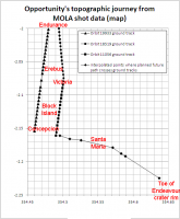
Thanks for that Emily, those plots are useful. One thing that might make the "Oppy Journey" plot even more useful would be markers at a few milestones along the route, such as Erebus, Concepcion, or something similar. (Victoria is pretty obvious.) With the understanding that this would be only crude, since the samples don't coincide exactly with the route.
Also, would it be possible to extend that plot with the few data samples along the projected route we've been following? Of course that's only projected, but it would give us some idea of what's to come. |
|
|
|
|
Aug 28 2010, 07:07 AM
Post
#634
|
|
|
Senior Member Group: Moderator Posts: 4279 Joined: 19-April 05 From: .br at .es Member No.: 253 |
QUOTE (fredk @ Aug 28 2010, 07:00 AM)  Also, would it be possible to extend that plot with the few data samples along the projected route we've been following? Of course that's only projected, but it would give us some idea of what's to come. I think that's exactly what's on the first graph (named "Opportunity's topographic journey from MOLA shot data") in Emily's article. Check the diamond-shaped plots. |
|
|
|
|
Aug 28 2010, 07:25 AM
Post
#635
|
|
|
Senior Member Group: Members Posts: 4246 Joined: 17-January 05 Member No.: 152 |
The diamond path "future path across MOLA tracks" extends to total distance 22km, which is our current odometry. So does that mean the horizontal axis ("straight line distance") is as-the-Martian-crow-flies from landing? Perhaps I was stumped by the coincidence that that crow-flies distance at Endeavour is the same as the current odometry?
|
|
|
|
|
Aug 28 2010, 11:23 AM
Post
#636
|
|
|
Senior Member Group: Members Posts: 2920 Joined: 14-February 06 From: Very close to the Pyrénées Mountains (France) Member No.: 682 |
Thank you Emily, this give more perspectives and more feeling that we're on flat terrain.
Assuming we'll ever climb Cape York, the "Distant vistas" will better appear but I don't think we'll feel to be on the rim of a crater looking down inside. From Mola's we'll be then around -1400 and the lowest point inside the crater I could find is -1971 but it's near the other side of Endeavour and may be not visible from Cape York. We'll have "-1600's" in the near distance but I don't think we'll have the same feeling of been on a summit like Spirit when she was on the "Everest". Flat terrain it is. -------------------- |
|
|
|
|
Aug 28 2010, 01:45 PM
Post
#637
|
|
 Senior Member Group: Admin Posts: 4763 Joined: 15-March 05 From: Glendale, AZ Member No.: 197 |
Hope I don't sound too clueless, but what do the unlabeled lines represent?
-------------------- If Occam had heard my theory, things would be very different now.
|
|
|
|
|
Aug 28 2010, 02:35 PM
Post
#638
|
|
|
Administrator Group: Admin Posts: 5172 Joined: 4-August 05 From: Pasadena, CA, USA, Earth Member No.: 454 |
The straight-line distance is along orbital tracks -- Opportunity's wheels have rolled much more than that as she's twisted and turned and rolled up to targets. I'll post a map guide if I have time this weekend.
Dan, I only turned on the labels for two representative ground tracks because to turn them all on totally covers the opening view with numbers and slows down your computer. Open the folder "MOLA shot points" (click the plus sign next to it) and turn on as many labels as you like. I've sorted the tracks in order -- all the ascending (yellow) tracks from west to east, followed by all the descending (orange) tracks from west to east. -------------------- My website - My Patreon - @elakdawalla on Twitter - Please support unmannedspaceflight.com by donating here.
|
|
|
|
|
Aug 28 2010, 03:18 PM
Post
#639
|
|
|
Senior Member Group: Admin Posts: 4763 Joined: 15-March 05 From: Glendale, AZ Member No.: 197 |
This is really awesome Emily. Thanks for taking the time to put it all together.
-------------------- If Occam had heard my theory, things would be very different now.
|
|
|
|
|
Aug 28 2010, 04:24 PM
Post
#640
|
|||
|
Administrator Group: Admin Posts: 5172 Joined: 4-August 05 From: Pasadena, CA, USA, Earth Member No.: 454 |
Fred, maybe this will help.
Attached thumbnail(s)
-------------------- My website - My Patreon - @elakdawalla on Twitter - Please support unmannedspaceflight.com by donating here.
|
||
|
|
|
||
|
Aug 28 2010, 05:35 PM
Post
#641
|
|
|
Senior Member Group: Members Posts: 4246 Joined: 17-January 05 Member No.: 152 |
Yeah, those look great, thanks Emily.
|
|
|
|
|
Sep 2 2010, 04:10 AM
Post
#642
|
||
 Senior Member Group: Members Posts: 1887 Joined: 20-November 04 From: Iowa Member No.: 110 |
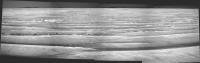
Latest drive topped a local rise and reveals an additional 'horizon' in the middle distance. Could be part of the parking lot terrain. There are some subtle bumps along it or possibly behind it south of the rimshot crater, Cape York?
|
|
|
|
|
|
|
Sep 2 2010, 06:54 AM
Post
#643
|
|
|
Senior Member Group: Moderator Posts: 4279 Joined: 19-April 05 From: .br at .es Member No.: 253 |
Here're some further data I gathered with Google Earth.
Cape York should be in the same line of sight as the crater and spanning 5 deg. to the right. Santa Maria should be 15 deg. left of the crater. |
|
|
|
|
Sep 2 2010, 07:58 AM
Post
#644
|
|
|
Junior Member Group: Members Posts: 41 Joined: 27-May 09 From: Burgundy Member No.: 4798 |
So, we can see Santa Maria !!!?
|
|
|
|
|
Sep 2 2010, 11:54 AM
Post
#645
|
|
 Senior Member Group: Moderator Posts: 2262 Joined: 9-February 04 From: Melbourne - Oz Member No.: 16 |
No, I don't think so. I'll see what i can do when at home later, but I can't see anything in the raws.
It does look like we can now see part of the parking lot. My gut feeling is that Santa Maria is still below the near horizon (and that the bit of the parking lot we can see is beyond it) So I wouldn't be surprised to see it pop into view any sol now. 
-------------------- |
|
|
|
|

|
Lo-Fi Version | Time is now: 25th April 2024 - 03:38 PM |
|
RULES AND GUIDELINES Please read the Forum Rules and Guidelines before posting. IMAGE COPYRIGHT |
OPINIONS AND MODERATION Opinions expressed on UnmannedSpaceflight.com are those of the individual posters and do not necessarily reflect the opinions of UnmannedSpaceflight.com or The Planetary Society. The all-volunteer UnmannedSpaceflight.com moderation team is wholly independent of The Planetary Society. The Planetary Society has no influence over decisions made by the UnmannedSpaceflight.com moderators. |
SUPPORT THE FORUM Unmannedspaceflight.com is funded by the Planetary Society. Please consider supporting our work and many other projects by donating to the Society or becoming a member. |
|