Satellite Feature Maps |

 Unmanned Spaceflight.com > Outer Solar System > Saturn > Cassini Huygens > Cassini general discussion and science results
Satellite Feature Maps |
 Feb 26 2012, 07:00 PM Feb 26 2012, 07:00 PM
Post
#1
|
||
 Senior Member  Group: Members Posts: 1628 Joined: 5-March 05 From: Boulder, CO Member No.: 184 |
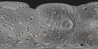
Greetings,
Here's a map with a feature overlay for Mimas:
Full resolution here: http://laps.noaa.gov/albers/sos/features/c..._180_center.png Steve -------------------- Steve [ my home page and planetary maps page ]
|
|
 |
 
|
|
 |
|
Mar 16 2012, 06:28 PM
Post
#2
|
||
|
Senior Member Group: Members Posts: 1628 Joined: 5-March 05 From: Boulder, CO Member No.: 184 |
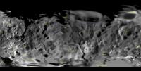
Here's what I have for a Phoebe feature map so far:
This uses the Cassini December 2005 map release PIA07775. There was a subsequent cartographic map release (e.g. PIA07795) that has some higher resolution imagery. However so far I've unable to find this version in a clean (unlabeled) cylindrical projection. The difference in the imagery is particularly noticeable around the craters Amphion and Eurytion. Steve -------------------- Steve [ my home page and planetary maps page ]
|
|
|
|
|
|
 scalbers Satellite Feature Maps Feb 26 2012, 07:00 PM
 scalbers I had earlier shown Enceladus in the post here: ht... Feb 26 2012, 07:42 PM scalbers Next in line is Rhea - here's what I have so f... Feb 27 2012, 09:13 PM MarcF Hey Steve,
Thank you very much for this great work... Feb 28 2012, 10:13 AM scalbers Marc, thanks for the comments and useful feedback.... Mar 3 2012, 05:37 PM scalbers For Titan, please check this thread:
http://www.u... Mar 3 2012, 08:25 PM scalbers This is what I have for Iapetus, with special atte... Mar 4 2012, 04:26 PM
scalbers I had earlier shown Enceladus in the post here: ht... Feb 26 2012, 07:42 PM scalbers Next in line is Rhea - here's what I have so f... Feb 27 2012, 09:13 PM MarcF Hey Steve,
Thank you very much for this great work... Feb 28 2012, 10:13 AM scalbers Marc, thanks for the comments and useful feedback.... Mar 3 2012, 05:37 PM scalbers For Titan, please check this thread:
http://www.u... Mar 3 2012, 08:25 PM scalbers This is what I have for Iapetus, with special atte... Mar 4 2012, 04:26 PM |

|
Lo-Fi Version | Time is now: 24th April 2024 - 05:44 PM |
|
RULES AND GUIDELINES Please read the Forum Rules and Guidelines before posting. IMAGE COPYRIGHT |
OPINIONS AND MODERATION Opinions expressed on UnmannedSpaceflight.com are those of the individual posters and do not necessarily reflect the opinions of UnmannedSpaceflight.com or The Planetary Society. The all-volunteer UnmannedSpaceflight.com moderation team is wholly independent of The Planetary Society. The Planetary Society has no influence over decisions made by the UnmannedSpaceflight.com moderators. |
SUPPORT THE FORUM Unmannedspaceflight.com is funded by the Planetary Society. Please consider supporting our work and many other projects by donating to the Society or becoming a member. |
|