Victoria Crater Vs Big Crater, Visibility |

  |
Victoria Crater Vs Big Crater, Visibility |
 Apr 2 2005, 06:03 PM Apr 2 2005, 06:03 PM
Post
#16
|
|
 Senior Member  Group: Members Posts: 2173 Joined: 28-December 04 From: Florida, USA Member No.: 132 |
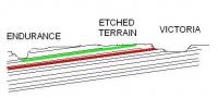
QUOTE (ElkGroveDan @ Apr 2 2005, 10:55 AM) Rarely is depositional bedding so uniform as to preclude the need for studies over a wide area. Endurance told a wonderful stratigraphic story, but by no means was it a complete story.  I wonder if this drawing is one possibility. The layers would not have to be tilted very much to get a look at layers that were not exposed at Endurance. Such layers may even be seen in the etched terrain. |
 |
 
|
|
Apr 2 2005, 06:06 PM
Post
#17
|
||
|
Senior Member Group: Members Posts: 2173 Joined: 28-December 04 From: Florida, USA Member No.: 132 |
QUOTE (ElkGroveDan @ Apr 2 2005, 10:55 AM) Rarely is depositional bedding so uniform as to preclude the need for studies over a wide area. Endurance told a wonderful stratigraphic story, but by no means was it a complete story. I wonder if this drawing is one possibility. The layers would not have to be tilted very much to get a look at layers that were not exposed at Endurance. Such layers may even be seen in the etched terrain.
Attached thumbnail(s)
|
|
|
|
|
|
|
Apr 2 2005, 08:44 PM
Post
#18
|
|
 Senior Member Group: Members Posts: 3419 Joined: 9-February 04 From: Minneapolis, MN, USA Member No.: 15 |
QUOTE (ElkGroveDan @ Apr 2 2005, 09:55 AM) Victoria is far enough away from Endurance to provide a necessary glimpse into a broader sample of the depositional history of the region. Moreover, since it is larger (did someone say five times?) then it will provide more opportunities for more nice clean exposed layers like Burns Cliff at varyious depths. At five times the diameter, Victoria will offer 20-30 times the circumference, and hence miles of new geologic observing that wasn't available at Endurance. You can bet the geologists won't be planning any summer vacations this year. More like fall and winter vacations. Considering how much larger the dunes become between here and Victoria, and considering how much of the evaporite layer is exposed (and just begging to be analyzed) within the etched terrain, my guess is that it will be September or October before we actually reach Victoria. -the other Doug -------------------- The trouble ain't that there is too many fools, but that the lightning ain't distributed right. -Mark Twain
|
|
|
|
|
Apr 3 2005, 02:05 AM
Post
#19
|
|
 Member Group: Members Posts: 809 Joined: 11-March 04 Member No.: 56 |
I was wondering if Victoria might end up being, visually, something of a Viking/Voyager writ large -- not a well-defined crater like Endurance, but a sandy depression surrounded by flat outcrops which don't emerge more than a meter or so from the surface.
|
|
|
|
|
Apr 3 2005, 08:58 AM
Post
#20
|
|
|
Founder Group: Chairman Posts: 14431 Joined: 8-February 04 Member No.: 1 |
No - Victoria is very big, very deep, and very much larger than Endurance - let alone viking and voyager
Doug |
|
|
|
|
Apr 4 2005, 04:36 AM
Post
#21
|
|
 Senior Member Group: Members Posts: 2228 Joined: 1-December 04 From: Marble Falls, Texas, USA Member No.: 116 |
QUOTE (centsworth_II @ Apr 2 2005, 12:06 PM) QUOTE (ElkGroveDan @ Apr 2 2005, 10:55 AM) Rarely is depositional bedding so uniform as to preclude the need for studies over a wide area. Endurance told a wonderful stratigraphic story, but by no means was it a complete story. I wonder if this drawing is one possibility. The layers would not have to be tilted very much to get a look at layers that were not exposed at Endurance. Such layers may even be seen in the etched terrain. At the LPSC it was mentioned that Opporunity will be climbing up the geological section as it heads south. I'd guess that is because the bedding is horizontal and Oppy is climbing in altitude, or that the bedding dips toward the south. As has been pointed out previously, any observations that can be made about the lateral and vertical variations in these fascinating rocks will be important. I really am hoping that the etched terrain will have vertical outcrops, so we can add to the type section. If the etched terain is anyting like what I am expecting, Opportunity will spend a lot of time there. -------------------- ...Tom
I'm not a Space Fan, I'm a Space Exploration Enthusiast. |
|
|
|
|
Apr 4 2005, 04:59 AM
Post
#22
|
|
 The Insider Group: Members Posts: 669 Joined: 3-May 04 Member No.: 73 |
I think it's likely that the climb in altitude is attributed to an ejecta blanket caused by the Victoria impact, in which case it's all just a bunch of rubble with no clear depositional layering, sort of what we saw around Endurance but in much grander scale.
Now, the cliffs inside Victoria may tell a nice story though, if they are reachable in any way 
|
|
|
|
|
Apr 4 2005, 05:48 AM
Post
#23
|
|
|
Senior Member Group: Members Posts: 3419 Joined: 9-February 04 From: Minneapolis, MN, USA Member No.: 15 |
QUOTE (Pando @ Apr 3 2005, 10:59 PM) I think it's likely that the climb in altitude is attributed to an ejecta blanket caused by the Victoria impact, in which case it's all just a bunch of rubble with no clear depositional layering, sort of what we saw around Endurance but in much grander scale. Now, the cliffs inside Victoria may tell a nice story though, if they are reachable in any way I disagree that the rise ahead is Victoria ejecta. It's too widespread and doesn't appear to be situated right to simply be Victoria ejecta. There is a crater roughly, what, four times the size of Victoria directly to the south of Erebus (the one I'm speaking of is very degraded, has a very dark duned plains floor, and probably looks a lot like Vostok in being eroded nearly to the ground). It, and a cluster of other craters similar in age and degradation (including Erebus at the northen border of the cluster) seem to sit along a ridge of somewhat higher elevation than the plains where we landed. It's possible that the rise in elevation we're looking at is an ejecta pile from that ancient crater cluster. Also arguing against this rise being Victoria ejecta, in my opinion, is that Victoria seems to lie on a plateau of the same kind of very flat plains unit where we landed. The MOLA data shows that it's a little higher in altitude than the plains where we landed, but it looks very similar. I'm guessing that the ejecta from the ancient crater cluster caused an initial landform rise, which was heavily modified by continuing epochal inundation by the brine sea we know was there. Once the sea receded for good, the relative roughness of the crater cluster terrain drove selective aeolian erosion patterns, which have resulted in the "etched" appearance we see today. Finally, relating to the smoothness of the "plateau" on which Victoria is located -- if we postulate that the plains where we landed *and* the plateau on which Victoria is located were all formed by the slow wind erosion of a reasonably flat evaporite layer, and the etched terrain was formed by wind erosion of jumbled and water-modified ejecta blankets of a cluster of fairly large craters, then it stands to reason that Victoria was formed well after the altitude rise and the differentiation between flat plains and etched terrain had already developed. Otherwise, we'd have to dismiss ejecta roughening as the reason for the types of wind erosion we see in the etched terrain. -the other Doug -------------------- The trouble ain't that there is too many fools, but that the lightning ain't distributed right. -Mark Twain
|
|
|
|
|
Apr 4 2005, 07:10 AM
Post
#24
|
|
|
The Insider Group: Members Posts: 669 Joined: 3-May 04 Member No.: 73 |
Looking at it again I think you are right - Victoria is a much younger crater compared to others nearby (Erebus and another larger one south-southwest).
This image shows an interesting pattern around Victoria (lighter colored terrain), but it's much too large to be ejecta from Viccy (which probably fueled by comment earlier). There has been much resurfacing due to impacts, and there appear to be some monster ones like the one on the south-east cornier of this image. I don't know if it's possible to tell though which craters were created during or after the "wet" period at Meridiani. |
|
|
|
|
Apr 4 2005, 06:15 PM
Post
#25
|
|
|
Senior Member Group: Members Posts: 3419 Joined: 9-February 04 From: Minneapolis, MN, USA Member No.: 15 |
QUOTE (Pando @ Apr 4 2005, 01:10 AM) I don't know if it's possible to tell though which craters were created during or after the "wet" period at Meridiani. Yeah -- that's a challenge. There are a lot of differences between obviously younger craters and ancient, degraded craters, including the old stand-bys of sharpness and blockiness. For example, Endurance and Victoria, while far different in size, look quite similar in morphology (at least from the orbital images) and might well be of similar ages. The cluster of which Erebus is a part is obviously a *lot* older and more degraded. But, if I'm reading it right, it appears that the ancient cluster has left an uneven terrain that promotes selective wind erosion, while the impacts causing both Endurance and Victoria did not. That might be a matter of the size of the impacts in the cluster, or the interaction of multiple ejecta blankets (assuming the cluster was made all at the same time, which is not a very provable assumoption). But it also might be that the ancient craters struck water-laden target rock and the later impacts of Endurance and Victoria struck mostly dried rocks. My thinking is that the difference in mass of volatiles in the target rock would make a difference in how impacts make the landforms deform, and could cause the relief that has created the etched terrain appearance (explaining why ejecta blankets around ancient craters are still somewhat preserved in the etched terrain, while ejecta blankets around the younger craters have either been completely worn down or are in the process of being flattened out of view). That's where I'm getting my (admitteldy WAG-ish) hypothesis that the ancient crater cluster was formed when the target rock was water-laden, and following it up with the further supposition that the resulting craters and ejecta were further modified by flowing and/or standing water by "cementing" the ancient craters' ejecta patterns with further overlays of evaporite that has "filled in the cracks" in the ejecta blankets. I think maybe the *only* way we can establish this kind of stratigraphic sequence in this area is going to be determining if impacts occurred in wet or dry rock -- and especially at this site, where there has been so much erosion of what seems to be a *very* soft and erodable evaporite layer, that's going to be even tougher. But since I observe that the erosion patterns, as well as the erosion results, of obviously older craters seems so different than the erosion patterns we see at the younger, sharper craters, I can't help but come to the conclusion that such a difference in the groundwater state at the time of the impacts may well be a factor... -the other Doug -------------------- The trouble ain't that there is too many fools, but that the lightning ain't distributed right. -Mark Twain
|
|
|
|
|
Apr 5 2005, 12:39 AM
Post
#26
|
|
|
Member Group: Members Posts: 307 Joined: 16-March 05 Member No.: 198 |
QUOTE (djellison @ Mar 31 2005, 10:37 AM) Vostok always looked flat to me - MOC imagery showed no elevation. However - there is almost certainly ( and infact, we can almost see in Erebus from where we are now ) quite a lot of elevation there. According to Steve Squyres--or at least as an article's report of him--"the etched terrain looks absolutely flat". (Mind you, that same article claims Victoria is "900 kilometers (560 miles) across with 40 meters of exposed sedimentary rock on the walls". At a guess the article's author mistook "560m" for 560 miles rather than 560 metres".) |
|
|
|
|
Apr 5 2005, 03:56 AM
Post
#27
|
|
 Member Group: Members Posts: 118 Joined: 14-March 05 Member No.: 195 |
QUOTE (dvandorn @ Apr 4 2005, 06:15 PM) QUOTE (Pando @ Apr 4 2005, 01:10 AM) I don't know if it's possible to tell though which craters were created during or after the "wet" period at Meridiani. Yeah -- that's a challenge. There are a lot of differences between obviously younger craters and ancient, degraded craters, including the old stand-bys of sharpness and blockiness. For example, Endurance and Victoria, while far different in size, look quite similar in morphology (at least from the orbital images) and might well be of similar ages. The cluster of which Erebus is a part is obviously a *lot* older and more degraded. But, if I'm reading it right, it appears that the ancient cluster has left an uneven terrain that promotes selective wind erosion, while the impacts causing both Endurance and Victoria did not. That might be a matter of the size of the impacts in the cluster, or the interaction of multiple ejecta blankets (assuming the cluster was made all at the same time, which is not a very provable assumoption). But it also might be that the ancient craters struck water-laden target rock and the later impacts of Endurance and Victoria struck mostly dried rocks. My thinking is that the difference in mass of volatiles in the target rock would make a difference in how impacts make the landforms deform, and could cause the relief that has created the etched terrain appearance (explaining why ejecta blankets around ancient craters are still somewhat preserved in the etched terrain, while ejecta blankets around the younger craters have either been completely worn down or are in the process of being flattened out of view). That's where I'm getting my (admitteldy WAG-ish) hypothesis that the ancient crater cluster was formed when the target rock was water-laden, and following it up with the further supposition that the resulting craters and ejecta were further modified by flowing and/or standing water by "cementing" the ancient craters' ejecta patterns with further overlays of evaporite that has "filled in the cracks" in the ejecta blankets. I think maybe the *only* way we can establish this kind of stratigraphic sequence in this area is going to be determining if impacts occurred in wet or dry rock -- and especially at this site, where there has been so much erosion of what seems to be a *very* soft and erodable evaporite layer, that's going to be even tougher. But since I observe that the erosion patterns, as well as the erosion results, of obviously older craters seems so different than the erosion patterns we see at the younger, sharper craters, I can't help but come to the conclusion that such a difference in the groundwater state at the time of the impacts may well be a factor... -the other Doug If these craters did happen upon "wet" rocks shouldn't it be rather easy to spot when looking at the fracturing within the impacted rocks? |
|
|
|
|
Apr 5 2005, 07:04 AM
Post
#28
|
|
|
Senior Member Group: Members Posts: 3419 Joined: 9-February 04 From: Minneapolis, MN, USA Member No.: 15 |
QUOTE (wyogold @ Apr 4 2005, 09:56 PM) If these craters did happen upon "wet" rocks shouldn't it be rather easy to spot when looking at the fracturing within the impacted rocks? Maybe it will. If my theory is correct, we're just now appraching the edge of the ejecta blankets from the ancient crater cluster. The problem, of course, is that the ejecta blankets have been highly degraded and modified since they were emplaced. I would guess, from the way the terrain looks, that the best shot for seeing exposed ridges of actual ejecta would be in the lightest patches of what looks like outcrop within the etched terrain. -the other Doug -------------------- The trouble ain't that there is too many fools, but that the lightning ain't distributed right. -Mark Twain
|
|
|
|
|
Sep 9 2005, 01:51 PM
Post
#29
|
|
|
Founder Group: Chairman Posts: 14431 Joined: 8-February 04 Member No.: 1 |
The figures I've heard are 10m of strata at Endurance, and up to 40 at Victoria.
Doug |
|
|
|
|

|
Lo-Fi Version | Time is now: 16th April 2024 - 01:52 PM |
|
RULES AND GUIDELINES Please read the Forum Rules and Guidelines before posting. IMAGE COPYRIGHT |
OPINIONS AND MODERATION Opinions expressed on UnmannedSpaceflight.com are those of the individual posters and do not necessarily reflect the opinions of UnmannedSpaceflight.com or The Planetary Society. The all-volunteer UnmannedSpaceflight.com moderation team is wholly independent of The Planetary Society. The Planetary Society has no influence over decisions made by the UnmannedSpaceflight.com moderators. |
SUPPORT THE FORUM Unmannedspaceflight.com is funded by the Planetary Society. Please consider supporting our work and many other projects by donating to the Society or becoming a member. |
|