InSight Surface Operations, 26 Nov 2018- 21 Dec 2022 |

  |
InSight Surface Operations, 26 Nov 2018- 21 Dec 2022 |
 Jul 15 2020, 08:45 PM Jul 15 2020, 08:45 PM
Post
#961
|
|
|
Senior Member  Group: Members Posts: 1582 Joined: 14-October 05 From: Vermont Member No.: 530 |
On Apollo, did they fly the third stages into the Moon to test the seismometers? Anything missions beginning with a Mars gravity assist soon? Too much of a Planetary Protection hurdle to jump?
|
 |
 
|
|
Jul 15 2020, 10:05 PM
Post
#962
|
|
|
Founder Group: Chairman Posts: 14432 Joined: 8-February 04 Member No.: 1 |
You intentionally target missions away from Mars so the upper stage has a tiny chance of - over 50 years - hitting the planet. You then use TCM 1 to tidy that up and put the spacecraft on a trajectory to intercept the planet. Upper stages are just not cleared for planetary protection.
|
|
|
|
|
Jul 16 2020, 02:09 AM
Post
#963
|
|
 Senior Member Group: Members Posts: 2530 Joined: 20-April 05 Member No.: 321 |
On the airless Moon, the energy of an artificial impactor would be perfectly known. On Mars, you'd also have to reckon with the loss of energy during entry be something of an unknown, and with an elongated object whose attitude is not controlled, that might be quite an uncontrolled variable.
|
|
|
|
|
Jul 16 2020, 02:37 AM
Post
#964
|
|
|
Solar System Cartographer Group: Members Posts: 10151 Joined: 5-April 05 From: Canada Member No.: 227 |
For Curiosity, the cruise stage and several balance masses struck the surface, and presumably it will be the same for Percy. So impacts are likely but may be too far away to be detected.
Edit: China's landing site is in Utopia Planitia, closer to InSight than Jezero is. I don't know if it will drop hardware during the descent, and I hope it will not crash but there could be a signal from that landing attempt. Phil -------------------- ... because the Solar System ain't gonna map itself.
Also to be found posting similar content on https://mastodon.social/@PhilStooke Maps for download (free PD: https://upload.wikimedia.org/wikipedia/comm...Cartography.pdf NOTE: everything created by me which I post on UMSF is considered to be in the public domain (NOT CC, public domain) |
|
|
|
|
Jul 17 2020, 03:37 AM
Post
#965
|
||
|
Solar System Cartographer Group: Members Posts: 10151 Joined: 5-April 05 From: Canada Member No.: 227 |
Some night-time images (6:30 pm local time) were taken on sol 580. I don't know why. This is the set of images merged and brightened a bit.
Phil
-------------------- ... because the Solar System ain't gonna map itself.
Also to be found posting similar content on https://mastodon.social/@PhilStooke Maps for download (free PD: https://upload.wikimedia.org/wikipedia/comm...Cartography.pdf NOTE: everything created by me which I post on UMSF is considered to be in the public domain (NOT CC, public domain) |
|
|
|
|
|
|
Jul 17 2020, 05:49 AM
Post
#966
|
|
 Senior Member Group: Members Posts: 2428 Joined: 30-January 13 From: Penang, Malaysia. Member No.: 6853 |
QUOTE (Phil Stooke @ Jul 17 2020, 11:37 AM)  Some night-time images (6:30 pm local time) were taken on sol 580. I don't know why. This is the set of images merged and brightened a bit. From the recent mission update from JPL: QUOTE Scientists also want to resume using the arm to spot meteors streaking across the night sky, as they did earlier in the mission. Doing so could help them predict how often meteors strike this part of the planet. They could also cross-check to see whether data from InSight's seismometer reveals a meteor impact on Mars shortly afterward. It does not look like a full blown attempt to spot meteors as there's only a small amount of sky in the frame, unless they dont want to point the camera at the sky during the dusty season, but it could have been an exercise to calibrate the camera for use at night? (akin to a noise check?) |
|
|
|
|
Jul 22 2020, 12:58 PM
Post
#967
|
|||
|
Senior Member Group: Members Posts: 2428 Joined: 30-January 13 From: Penang, Malaysia. Member No.: 6853 |
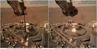
Then & Now: About 17 months between these frames of a section of InSight's deck (both after deployment of the WTS and HP3). 2 processed IDC images from Sols 85 and 584. I've included an animated GIF and a side-by-side comparison. Besides the grapple, the most obvious changes are the dust levels, as well as the softened shadows (probably as a result of the increased levels of suspended dust in the atmosphere). Also note what appears to be a little relaxation in the HP3 engineering tether that stretches across the deck.
|
||
|
|
|
||
|
Jul 31 2020, 06:11 PM
Post
#968
|
||
|
Solar System Cartographer Group: Members Posts: 10151 Joined: 5-April 05 From: Canada Member No.: 227 |
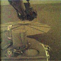
This is a night IDC image from sol 593 taken about 10 pm or 22 hours local lander time (here, denoised to some extent and contrast stretched). Presumably this is a meteor search image, or at least a test of meteor imaging - there was only one frame. I was interested to observe that there is a faint dark patch, indicated with arrows at right, corresponding to the end of the arm as seen in every IDC image. Is it an artifact, a persistent image burned into the chip? Or is it a silhouette of the arm against a scene which is not totally dark, lit by stars, scattered sunlight even this far from the terminator, light reflected off Phobos or even an aurora? If it was sky brightness I might expect to see the horizon but I don't see it, though probably it's well above the horizon. (EDIT: yes, must be pointing high, the daytime images show that)
Phil -------------------- ... because the Solar System ain't gonna map itself.
Also to be found posting similar content on https://mastodon.social/@PhilStooke Maps for download (free PD: https://upload.wikimedia.org/wikipedia/comm...Cartography.pdf NOTE: everything created by me which I post on UMSF is considered to be in the public domain (NOT CC, public domain) |
|
|
|
|
|
|
Jul 31 2020, 10:47 PM
Post
#969
|
|
 Martian Photographer Group: Members Posts: 352 Joined: 3-March 05 Member No.: 183 |
The effect was noted in the Banfield et al. Nature paper. It is not burn-in; a test looking at the ground at night was done, and the image must be of the sky to detect it. Later images show that when Phobos is up, the brightness can about double. I don't believe the explanation in the paper (umm, I wrote it); but it seems to me to be somewhat too bright for star light, and way too bright for anything else. So maybe star light?
|
|
|
|
|
Jul 31 2020, 11:28 PM
Post
#970
|
|
 Senior Member Group: Members Posts: 4246 Joined: 17-January 05 Member No.: 152 |
Here on Earth the night sky brightness is dominated by airglow, at dark sites. Recently there was a measurement from TGO of martian airglow. I don't know how its brightness compares to Earth's, but perhaps this adds significantly to the somewhat low starlight contribution?
BTW, great catch, Phil! |
|
|
|
|
Aug 2 2020, 11:50 AM
Post
#971
|
||
|
Senior Member Group: Members Posts: 2428 Joined: 30-January 13 From: Penang, Malaysia. Member No.: 6853 |
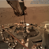
After a few weeks of performing other activities the robotic arm returned to the saving the mole campaign earlier today on Mars (sol 598). Here's a processed IDC frame that shows some back-filling of the shallow pit around the mole. I'm presuming that additional images are in the pipeline and we may have a better picture once they are all down, but I thought I'd share this one now.
#savethemole 
|
|
|
|
|
|
|
Aug 4 2020, 03:13 AM
Post
#972
|
||
|
Senior Member Group: Members Posts: 2428 Joined: 30-January 13 From: Penang, Malaysia. Member No.: 6853 |
A number of IDC images were acquired on Sol 599 from different positions around the pit, I presume this was to make a 3D model of the partially filled pit prior to deciding the next step(s)
I used MS ICE to assemble the frames together to make a mosaic that I cropped to remove the arm(s), as this provides a slightly better view of the scrape, the partially filled pit and the rest of the ground around the pit in case they decide to scrape in some more material before proceeding.
#SaveTheMole
|
|
|
|
|
|
|
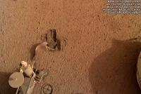
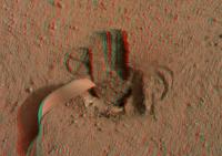
Aug 4 2020, 04:20 PM
Post
#973
|
|||
|
Senior Member Group: Members Posts: 4246 Joined: 17-January 05 Member No.: 152 |
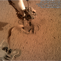
Cross-eyed view:
and anaglyph:
|
||
|
|
|
||
|
Aug 11 2020, 09:35 AM
Post
#974
|
|
|
Senior Member Group: Members Posts: 2428 Joined: 30-January 13 From: Penang, Malaysia. Member No.: 6853 |
DLR Mission Logbook entry updated (10 August 2020)
https://www.dlr.de/blogs/en/desktopdefault....9577_read-1144/ |
|
|
|
|
Aug 11 2020, 01:49 PM
Post
#975
|
|
|
Senior Member Group: Members Posts: 1582 Joined: 14-October 05 From: Vermont Member No.: 530 |
So they didn't intend to bury it, but nonetheless will give it one more push.
Thermal conductance increased, which means better contact with regolith. Encouraging. |
|
|
|
|

|
Lo-Fi Version | Time is now: 26th April 2024 - 06:06 PM |
|
RULES AND GUIDELINES Please read the Forum Rules and Guidelines before posting. IMAGE COPYRIGHT |
OPINIONS AND MODERATION Opinions expressed on UnmannedSpaceflight.com are those of the individual posters and do not necessarily reflect the opinions of UnmannedSpaceflight.com or The Planetary Society. The all-volunteer UnmannedSpaceflight.com moderation team is wholly independent of The Planetary Society. The Planetary Society has no influence over decisions made by the UnmannedSpaceflight.com moderators. |
SUPPORT THE FORUM Unmannedspaceflight.com is funded by the Planetary Society. Please consider supporting our work and many other projects by donating to the Society or becoming a member. |
|