Martian Cartography |

  |
Martian Cartography |
 Jan 22 2009, 12:13 AM Jan 22 2009, 12:13 AM
Post
#16
|
|
|
Senior Member  Group: Members Posts: 2542 Joined: 13-September 05 Member No.: 497 |
QUOTE (elakdawalla @ Jan 21 2009, 02:14 PM)  Does the shape of Mars and the variety of mapping conventions that have been used over the years cause problems with geographic features appearing to shift from one mission to the next? The main problem other than registration errors has been the various redefinitions of W0 and to a lesser extent, the IAU spheroid. See http://astrogeology.usgs.gov/Teams/Geomati...esy/P22D-06.pdf Hopefully we are now past these problems, at least at the 100-meter scale. -------------------- Disclaimer: This post is based on public information only. Any opinions are my own.
|
 |
 
|
|
Jan 23 2009, 02:55 PM
Post
#17
|
||
|
Solar System Cartographer Group: Members Posts: 10226 Joined: 5-April 05 From: Canada Member No.: 227 |
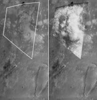
Here is a comparison between a MOC wide-angle mosaic - courtesy of Malin Space Science Systems - and a reprojected version of Mariner 4 frame 1. I can't recall seeing this frame matched to topography before (correct me if I'm wrong). At the time I think people said many features were likely atmospheric rather than on the surface, but this comparison shows a very close match even to the smallest bright spots on the surface. It also suggests only the most trivial changes have occurred in this area. Orcus Patera at bottom right gives the location. Blinking the two halves reinforces the close match.
Phil
-------------------- ... because the Solar System ain't gonna map itself.
Also to be found posting similar content on https://mastodon.social/@PhilStooke Maps for download (free PDF: https://upload.wikimedia.org/wikipedia/comm...Cartography.pdf NOTE: everything created by me which I post on UMSF is considered to be in the public domain (NOT CC, public domain) |
|
|
|
|
|
|
Feb 1 2009, 09:04 PM
Post
#18
|
||
|
Solar System Cartographer Group: Members Posts: 10226 Joined: 5-April 05 From: Canada Member No.: 227 |
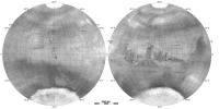
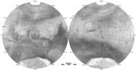
This is Mars as it was known just after the Mariner 6 flyby. The background is Mariner 6 far encounter frames, except the north pole which is filled in with a USAF map based on telescopic data. Superimposed on that are the Mariner 4 images (left hemisphere) and Mariner 6's near encounter frames (right side).
Phil
-------------------- ... because the Solar System ain't gonna map itself.
Also to be found posting similar content on https://mastodon.social/@PhilStooke Maps for download (free PDF: https://upload.wikimedia.org/wikipedia/comm...Cartography.pdf NOTE: everything created by me which I post on UMSF is considered to be in the public domain (NOT CC, public domain) |
|
|
|
|
|
| Guest_PhilCo126_* |
Feb 2 2009, 06:17 PM
Post
#19
|
|
Guests |
This is a nice poster: Mariner IV Mars flyby 1965
|
|
|
|
|
Feb 2 2009, 06:27 PM
Post
#20
|
|
|
Solar System Cartographer Group: Members Posts: 10226 Joined: 5-April 05 From: Canada Member No.: 227 |
It's a very nice poster, but the locations of the first few images are based on predictions, not feature mapping, and they are not very reliable. The inset at lower left shows the area of image no. 3. It suggests that this was the first one for which surface features could be identified. My post above in this thread shows that even image 1 reveals actual surface features, but they were not recognized at the time.
(sorry, Tayfun!) Phil -------------------- ... because the Solar System ain't gonna map itself.
Also to be found posting similar content on https://mastodon.social/@PhilStooke Maps for download (free PDF: https://upload.wikimedia.org/wikipedia/comm...Cartography.pdf NOTE: everything created by me which I post on UMSF is considered to be in the public domain (NOT CC, public domain) |
|
|
|
|
Feb 2 2009, 08:48 PM
Post
#21
|
|
 Member Group: Members Posts: 106 Joined: 26-September 05 Member No.: 508 |
QUOTE (Phil Stooke @ Feb 2 2009, 08:27 PM) (sorry, Tayfun!) Phil  As far as I remember it was based on a figure from a very old article by Leighton, if I can find the original file I will update the poster. As far as I remember it was based on a figure from a very old article by Leighton, if I can find the original file I will update the poster.
|
|
|
|
|
Feb 2 2009, 09:13 PM
Post
#22
|
|
|
Solar System Cartographer Group: Members Posts: 10226 Joined: 5-April 05 From: Canada Member No.: 227 |
Don't worry, you didn't do it incorrectly, it was your source that was wrong. The original image location predictions are a bit off.
Phil -------------------- ... because the Solar System ain't gonna map itself.
Also to be found posting similar content on https://mastodon.social/@PhilStooke Maps for download (free PDF: https://upload.wikimedia.org/wikipedia/comm...Cartography.pdf NOTE: everything created by me which I post on UMSF is considered to be in the public domain (NOT CC, public domain) |
|
|
|
|
Feb 4 2009, 05:22 PM
Post
#23
|
||
|
Solar System Cartographer Group: Members Posts: 10226 Joined: 5-April 05 From: Canada Member No.: 227 |
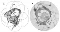
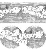
Here's the very beginning of Mars cartography. Who drew the first map of Mars? It wasn't Beer and Madler, as most sources seem to assume. It was William Herschel, in 1783. This is his map, compared with a map drawn in 1962 by the U. S. Air Force for NASA.
Herschel drew Mars over several weeks, observing all longitudes eventually. The small south polar cap was visible in every drawing. He conceived the idea of arranging the full disk images like flower petals, using the polar cap as a fixed central point, so he could see the global distribution of dark markings. In my illustration, his map (labelled A) shows that pattern, with an overlay of circles indicating the individual views which made up his set of observations. In his original, each circle is labelled with the date of observation. Map B is the USAF MEC-1 Prototype made by the Aeronautical Chart and Information Center in 1962 for NASA's Mars mission planning. I have removed the grid and placenames and reprojected it to match the south polar projection of Herschel's map. The shape of Sinus Meridiani and Sinus Sabaeus at left will be familiar to Mars viewers. The bulge above it is Syrtis Major, not as pointed as in the USAF map, and the triangle at the bottom is probably Lunae Lacus, or a confused combination of that and Margaritifer Sinus. The hook shape at the top is Thoth-Nepenthes. Phil
-------------------- ... because the Solar System ain't gonna map itself.
Also to be found posting similar content on https://mastodon.social/@PhilStooke Maps for download (free PDF: https://upload.wikimedia.org/wikipedia/comm...Cartography.pdf NOTE: everything created by me which I post on UMSF is considered to be in the public domain (NOT CC, public domain) |
|
|
|
|
|
|
Feb 5 2009, 01:34 AM
Post
#24
|
|
 Interplanetary Dumpster Diver Group: Admin Posts: 4404 Joined: 17-February 04 From: Powell, TN Member No.: 33 |
Excellent work! I have worked with a lot of these images, but making a map like this is out of my league!
-------------------- |
|
|
|
|
Feb 5 2009, 01:45 AM
Post
#25
|
|||
|
Interplanetary Dumpster Diver Group: Admin Posts: 4404 Joined: 17-February 04 From: Powell, TN Member No.: 33 |
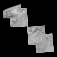
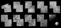
QUOTE (Phil Stooke @ Jan 23 2009, 03:55 PM) Here is a comparison between a MOC wide-angle mosaic - courtesy of Malin Space Science Systems - and a reprojected version of Mariner 4 frame 1. I can't recall seeing this frame matched to topography before (correct me if I'm wrong). At the time I think people said many features were likely atmospheric rather than on the surface, but this comparison shows a very close match even to the smallest bright spots on the surface. It also suggests only the most trivial changes have occurred in this area. Orcus Patera at bottom right gives the location. Blinking the two halves reinforces the close match. Phil This makes sense, based on my mosaic of the first four frames.
Here is my complete set of two frame mosaics....the image in the lower right hand corner is a telescopic view of the area taken around the time of the flyby.
-------------------- |
||
|
|
|
||
|
Feb 23 2009, 04:07 PM
Post
#26
|
||
|
Solar System Cartographer Group: Members Posts: 10226 Joined: 5-April 05 From: Canada Member No.: 227 |
I posted a map showing Mars as it was known after the Mariner 6 flyby, a bit earlier. Here's the post-Mariner 7 version. A slight misregistration of the Mariner 6 near encounter mosaic has been corrected here.
Phil
-------------------- ... because the Solar System ain't gonna map itself.
Also to be found posting similar content on https://mastodon.social/@PhilStooke Maps for download (free PDF: https://upload.wikimedia.org/wikipedia/comm...Cartography.pdf NOTE: everything created by me which I post on UMSF is considered to be in the public domain (NOT CC, public domain) |
|
|
|
|
|
|
Feb 26 2009, 01:03 PM
Post
#27
|
|
|
Junior Member Group: Members Posts: 68 Joined: 10-September 05 Member No.: 493 |
Main results current and history cartography Mars
http://www.planetary.brown.edu/pdfs/3416.pdf http://adsabs.harvard.edu/abs/2008AGUFM.P31D..04E ftp://ftp.lpi.usra.edu/pub/outgoing/lpsc2009/full626.pdf Mariner-9 (1971-1972) 85% 1-2 km 7329 picture Viking-1,2 (1976-1978) 97% 300 m 51539 picture MGS (1999-2006) 100% 225m 93893+32414 picture 3% 1.4-12m 85859 picture Mars Odyssey (2001-2006) 19% <20 m 35% <50 m Mars Express (2003-2008) 50% 15 m 100% 30 m Mars Reconnaissance orbiter (2006-2008) 38% 6 m 0.6% 0.25-1.2 m 9549 picture My prediction future for 2015 Mars Express - 15 metres resolution 3D color global map Mars Mars Reconnaissance orbiter - 6 metres resolution monochrome global map Mars MGS+MEX+MRO 0.25-2.5 metres resolution 10% map Mars -------------------- |
|
|
|
|
Feb 26 2009, 02:08 PM
Post
#28
|
|
|
Founder Group: Chairman Posts: 14434 Joined: 8-February 04 Member No.: 1 |
You can scrap MEX from your last line. It can't produced imagery at 2.5m/pixel - the SRC channel that it has is out of focus, so it's best imagery is basically the HRSC Nadir Channel.
Also - at 0.6% in 2 years - a further 6 years will allow MRO to have mapped a further 1.8% - for a total of 2.4% at <2.5m res. Add on MGS's 3% (not all of which is < 2.5m/pixel). That's 5.4%. Where are you getting 10% from? It would take MRO 20+ years to get to that figure. |
|
|
|
|
Feb 26 2009, 02:50 PM
Post
#29
|
|
|
Junior Member Group: Members Posts: 68 Joined: 10-September 05 Member No.: 493 |
10% were not precise calculations, but just at random assumption
The future can be better than plans! Example http://www.planetary.brown.edu/pdfs/3416.pdf Context camera (CTX) Planned: 15% (R=6m/px) http://adsabs.harvard.edu/abs/2008AGUFM.P31D..04E As of 31 August 2008, 36% of Mars was imaged at 6 m/pixel and 10.8% was covered more than once. -------------------- |
|
|
|
|
Aug 27 2009, 09:28 PM
Post
#30
|
||
|
Solar System Cartographer Group: Members Posts: 10226 Joined: 5-April 05 From: Canada Member No.: 227 |
Here is a very unusual Mars map - in two different projections. If anybody can identify its source* I'll give them a virtual Mars Bar. Answer next week...
Phil
* I mean its original source - it didn't look exactly like this originally, I have made changes. -------------------- ... because the Solar System ain't gonna map itself.
Also to be found posting similar content on https://mastodon.social/@PhilStooke Maps for download (free PDF: https://upload.wikimedia.org/wikipedia/comm...Cartography.pdf NOTE: everything created by me which I post on UMSF is considered to be in the public domain (NOT CC, public domain) |
|
|
|
|
|
|

|
Lo-Fi Version | Time is now: 23rd September 2024 - 06:37 PM |
|
RULES AND GUIDELINES Please read the Forum Rules and Guidelines before posting. IMAGE COPYRIGHT |
OPINIONS AND MODERATION Opinions expressed on UnmannedSpaceflight.com are those of the individual posters and do not necessarily reflect the opinions of UnmannedSpaceflight.com or The Planetary Society. The all-volunteer UnmannedSpaceflight.com moderation team is wholly independent of The Planetary Society. The Planetary Society has no influence over decisions made by the UnmannedSpaceflight.com moderators. |
SUPPORT THE FORUM Unmannedspaceflight.com is funded by the Planetary Society. Please consider supporting our work and many other projects by donating to the Society or becoming a member. |
|