Cape York - Northern Havens, Sol 2780 - 2947 |

  |
Cape York - Northern Havens, Sol 2780 - 2947 |
 Dec 12 2011, 01:33 AM Dec 12 2011, 01:33 AM
Post
#196
|
||
|
Member  Group: Members Posts: 808 Joined: 10-October 06 From: Maynard Mass USA Member No.: 1241 |
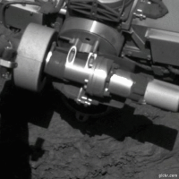
Here is an animation from the pancam on Sol2801(?)
The IDD is in the frame and then a picture of the rock below (not sure of the feature name) The filters are all right-eye
-------------------- CLA CLL
|
|
 |
 
|
|
|
Dec 12 2011, 05:35 PM
Post
#197
|
||
|
Member Group: Senior Member Posts: 136 Joined: 8-August 06 Member No.: 1022 |
Hi Folks:
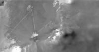
Because it's a nice round number, or maybe because we have so many overlapping navcam pans in this location, I thought I'd output a 1cm/pixel map of our current (and recent) locations. best, -Tim.
Attached thumbnail(s)
|
|
|
|
|
|
|
Dec 12 2011, 11:39 PM
Post
#198
|
|
|
Member Group: Members Posts: 154 Joined: 21-April 05 From: Rochester, New York, USA Member No.: 336 |
QUOTE (tim53 @ Dec 12 2011, 12:35 PM)  Because it's a nice round number, or maybe because we have so many overlapping navcam pans in this location, I thought I'd output a 1cm/pixel map of our current (and recent) locations. I think this should be called a splat-o-gram. |
|
|
|
|
Dec 13 2011, 12:37 AM
Post
#199
|
|
 Member Group: Members Posts: 267 Joined: 5-February 06 Member No.: 675 |
QUOTE (tim53 @ Dec 12 2011, 12:35 PM) Because it's a nice round number, or maybe because we have so many overlapping navcam pans in this location, I thought I'd output a 1cm/pixel map of our current (and recent) locations. Superbly detailed image! How did you do it?SteveM |
|
|
|
|
Dec 13 2011, 02:19 PM
Post
#200
|
|
|
Member Group: Members Posts: 808 Joined: 10-October 06 From: Maynard Mass USA Member No.: 1241 |
Steve, its all goes together with the right projection mapping software and enough navcam images
But I am pretty sure that Tim P. could have pulled it off just with scissors and elmer's glue 
-------------------- CLA CLL
|
|
|
|
|
Dec 13 2011, 04:59 PM
Post
#201
|
|
|
Member Group: Senior Member Posts: 136 Joined: 8-August 06 Member No.: 1022 |
QUOTE (PDP8E @ Dec 13 2011, 07:19 AM) Steve, its all goes together with the right projection mapping software and enough navcam images But I am pretty sure that Tim P. could have pulled it off just with scissors and elmer's glue I use a special version of our planning software that has my 35 gigapixel georeferenced HiRISE/CTX base map as a background, and projects the Navcam panoramas onto a terrain mesh derived from the stereo. So, rocks and stuff are not only in the right direction, they're at the right distance, too. The terrain mesh falls apart about 20 meters out, on flat terrain, though. -Tim. |
|
|
|
|
Dec 13 2011, 09:57 PM
Post
#202
|
||
|
Senior Member Group: Members Posts: 2998 Joined: 30-October 04 Member No.: 105 |
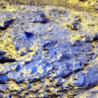
Here is a preliminary Rx21 (an R721 with guesstimated Red channel info) of the IDD site Boesmanskop on Sol-2801, indicated as "post-Brush". I've not been able to match the MI's up with the Pancams, but I think they are near the center of the image or slightly above center. And I can't hardly see the Brushed area, though I've not closely compared the pre- and post-brush grayscales. Hopefully we'll get a few more Pancams over the next few days, so enjoy.
In the meantime, let me toss out my initial impression of the MIs of this site: "drusy vugs". --Bill
Attached thumbnail(s)
-------------------- |
|
|
|
|
|
|
Dec 14 2011, 03:43 PM
Post
#203
|
|
|
Member Group: Members Posts: 267 Joined: 5-February 06 Member No.: 675 |
QUOTE (tim53 @ Dec 13 2011, 11:59 AM) I use a special version of our planning software that ... projects the Navcam panoramas onto a terrain mesh derived from the stereo. So, rocks and stuff are not only in the right direction, they're at the right distance, too. The terrain mesh falls apart about 20 meters out, on flat terrain, though. The result is very nice. Any advantage in blending the stereo terrain mesh into a HiRise DTM at 20 meters to extend this process?-Tim. SteveM |
|
|
|
|
Dec 15 2011, 04:01 PM
Post
#204
|
|
|
Member Group: Senior Member Posts: 136 Joined: 8-August 06 Member No.: 1022 |
QUOTE (SteveM @ Dec 14 2011, 08:43 AM) The result is very nice. Any advantage in blending the stereo terrain mesh into a HiRise DTM at 20 meters to extend this process? SteveM I can think of a lot of advantages! I sometimes use another program written by Jeff Hall in MIPL to map project the pancam data, which extends these maps out another 20 meters or so, where the pancam data is available. But the project doesn't have the resources to include the HiRISE DTM in the planning software. Curiosity will, however. I wish I were a programmer, but I'm not. I have to enlist the services of those who are. -Tim. |
|
|
|
|
Dec 16 2011, 04:18 AM
Post
#205
|
|
|
Junior Member Group: Members Posts: 98 Joined: 17-July 11 From: Pasadena, CA Member No.: 6066 |
QUOTE (tim53 @ Dec 15 2011, 08:01 AM) I can think of a lot of advantages! I sometimes use another program written by Jeff Hall in MIPL to map project the pancam data, which extends these maps out another 20 meters or so, where the pancam data is available. But the project doesn't have the resources to include the HiRISE DTM in the planning software. Curiosity will, however. I wish I were a programmer, but I'm not. I have to enlist the services of those who are. -Tim. Wishes: 1) More project resources for more of the pretty 2) Navcam complete 360s at 1 bazillion bits per pixel I do believe that would satisfy our Tim! -m |
|
|
|
|
Dec 16 2011, 06:23 AM
Post
#206
|
|
 Senior Member Group: Members Posts: 2228 Joined: 1-December 04 From: Marble Falls, Texas, USA Member No.: 116 |
QUOTE (tim53 @ Dec 15 2011, 10:01 AM) ... I wish I were a programmer, but I'm not. I have to enlist the services of those who are. ... No kidding... If I could do it all over again I would do a second degree, or major, or at least a minor in computer programming. Being a scientist or engineer with the ability to write computer code would be an incredible advantage in today's world.-------------------- ...Tom
I'm not a Space Fan, I'm a Space Exploration Enthusiast. |
|
|
|
|
Dec 16 2011, 09:31 PM
Post
#207
|
||
 Member Group: Members Posts: 404 Joined: 5-January 10 Member No.: 5161 |
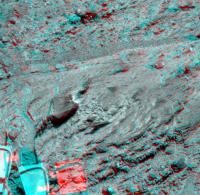
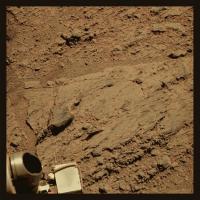
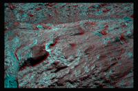
Very interesting rock close-up from Sol 2803. There's a particularly sharp "spike," and some bright material as if a seagull had perched there. Powdered/eroded gypsum? Very nice in 3D! Looking forward to color renditions of this outcrop.
|
|
|
|
|
|
|
Dec 16 2011, 09:31 PM
Post
#208
|
||
 The Poet Dude Group: Moderator Posts: 5551 Joined: 15-March 04 From: Kendal, Cumbria, UK Member No.: 60 |
Some more luvverly rocks...
-------------------- |
|
|
|
|
|
|
Dec 16 2011, 09:58 PM
Post
#209
|
||
|
The Poet Dude Group: Moderator Posts: 5551 Joined: 15-March 04 From: Kendal, Cumbria, UK Member No.: 60 |
You're right, Walfy... this is one fascinating-looking rocky area...
-------------------- |
|
|
|
|
|
|
Dec 17 2011, 03:06 AM
Post
#210
|
||
|
Junior Member Group: Members Posts: 98 Joined: 17-July 11 From: Pasadena, CA Member No.: 6066 |
QUOTE (walfy @ Dec 16 2011, 01:31 PM) Very interesting rock close-up from Sol 2803. There's a particularly sharp "spike," and some bright material as if a seagull had perched there. Powdered/eroded gypsum? Very nice in 3D! Looking forward to color renditions of this outcrop.
Wow, I didn't even notice that one... The one we're IDD'ing (or now done IDD'ing) was that smoother bit to the left, a "clast". The science team wanted the "matrix" rock (Boesmanskop), some soil near it, and a nearby "clast" to tell a full story. I'm not sure what they expect. Compositionally I don't expect anything different than Transvaal, though I'm no scientist... -m |
|
|
|
|
|
|

|
Lo-Fi Version | Time is now: 23rd April 2024 - 11:14 PM |
|
RULES AND GUIDELINES Please read the Forum Rules and Guidelines before posting. IMAGE COPYRIGHT |
OPINIONS AND MODERATION Opinions expressed on UnmannedSpaceflight.com are those of the individual posters and do not necessarily reflect the opinions of UnmannedSpaceflight.com or The Planetary Society. The all-volunteer UnmannedSpaceflight.com moderation team is wholly independent of The Planetary Society. The Planetary Society has no influence over decisions made by the UnmannedSpaceflight.com moderators. |
SUPPORT THE FORUM Unmannedspaceflight.com is funded by the Planetary Society. Please consider supporting our work and many other projects by donating to the Society or becoming a member. |
|