Printable Version of Topic
Click here to view this topic in its original format
Unmanned Spaceflight.com _ MSL _ Exploring Mt Sharp north of the dunes - Part 1: Beyond Pahrump Hills
Posted by: elakdawalla Mar 12 2015, 08:38 PM
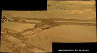
Finally drove away from Pahrump Hills on sol 923. Wheel tracks sure are piling up at the end of the drive -- there seems to have been quite a bit of slip.
[admin note: I was going to start a new thread for this, but realized our thread naming may be a bit out of whack because we're really not journeying to Mt Sharp anymore, are we? We'll discuss it with admins and I'll move/rename posts when we figure out our naming schema.]

|
Posted by: ngunn Mar 12 2015, 09:49 PM

Isn't 'Mount Sharp' essentially the name of a topographic feature rather than a geologic one?. We may have arrived at rocks that are from the same unit as the base of the mountain but we certainly haven't arrived at the mountain, so I'd say the team were stretching a point to make a point (with good reason) when they announced the 'arrival' and that the thread title's fine.
Posted by: fredk Mar 12 2015, 11:11 PM
I agree with ngunn that it's reasonable to say we're still "journeying to Mt Sharp". But the precise boundary of the topographic feature is not well defined, so at some (somewhat arbitrary) point in the future some moderator will have to put their foot down and say "we've arrived".
Posted by: Explorer1 Mar 12 2015, 11:33 PM
Maybe after passing the dune fields would be as good a point as any in the meantime? It could be titled 'final approach', or 'ascent beginning'?
Posted by: Phil Stooke Mar 13 2015, 03:51 PM
http://www.midnightplanets.com/web/MSL/image/00924/NRB_479523710EDR_F0450774NCAM00277M_.html
<sings> You're so vein, you prob'ly think this image is of you... <backtoprose>
Yes, vein alert! Very interesting area.
Phil
Posted by: elakdawalla Mar 13 2015, 03:56 PM
Well, according to the mission, we arrived at Mount Sharp as we approached Pahrump Hills, and the rocks we're driving on now are basal to Mount Sharp. But I won't rename the old thread.
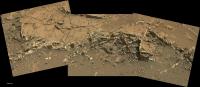
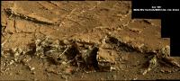
We've driven onto some rocks with some pretty interesting-looking veins:
|
Posted by: Phil Stooke Mar 13 2015, 04:45 PM
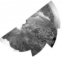
A quick circular view of the region - half a circle anyway.
Phil
|
Posted by: brellis Mar 14 2015, 01:58 AM
I had a brief gasp  when I read "we're not journeying to Mt. Sharp anymore, are we?" -- I wondered if plans to climb after adequate science has occurred at the base had changed. ack, I'm still the kid in the back seat who wants the panoramic view and to see Curiosity hold the altitude title.
Posted by: atomoid Mar 14 2015, 02:35 AM
http://www.midnightplanets.com/web/MSL/image/00924/NLB_479523648EDR_F0450774NCAM00277M_.html...And a two-hump camel makes an ummm..  (http://www.solspot.com/files/2011/12/camel-poop-taro-gomi.jpg kidding!)

|
Posted by: jvandriel Mar 14 2015, 07:49 AM
The road ahead.
The MastCam L view on Sol 923.
Jan van Driel
|
|
Posted by: jvandriel Mar 14 2015, 12:12 PM
The partial Navcam L view on Sol 924.
Jan van Driel
|
Posted by: jvandriel Mar 14 2015, 04:10 PM
Mastcam L view on Sol 924.
Jan van Driel
|
Posted by: PaulH51 Mar 14 2015, 11:29 PM
I believe that Joe's drive log derives drive distance on wheel rotation data. If that is still the case, then we also appear to have had significant wheel slip during the sol 924 drive. JPL issued a point to point distance of 6.13 meters, Joe's page indicates >20m, this could be corruption in the NAIF data, or slip.
The rear pointing NavCam images of the drive on 624 are only down as thumbnails so far, but the wheel track in one of those thumbs looks similar to the deep tracks on the 923 drive. Joe's http://curiosityrover.com/tracking/speedplot.php?drivenum=267 has some really interesting sharp fluctuations in elevation that don't seem to reflect the path, could this be recording the wheels digging in a little until forward progress was made?
Posted by: djellison Mar 14 2015, 11:34 PM
NAIF reports raw rover motion ( thus not accounting for slip ) at first until it's bundle adjusted and then it'll be normalized back to the 6m distance as I understand it.
Posted by: xflare Mar 15 2015, 06:03 PM
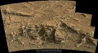
YES! Looks like we are going to take a look at all those veins
http://mars.jpl.nasa.gov/msl/multimedia/raw/?rawid=FRB_479702715EDR_F0450852FHAZ00302M_&s=926.565191980773
Posted by: jvandriel Mar 15 2015, 09:14 PM
The Navcam L view on Sol 926.
Jan van Driel.
|
Posted by: Phil Stooke Mar 16 2015, 12:59 AM
What amazing veins. I'm irresistibly drawn to the old description of the discovery of gold in the Klondike:
"gold lying thick between flaky slabs of rock like cheese in a sandwich"
Phil (reporting from LPSC)
Posted by: tanjent Mar 16 2015, 04:05 AM
Don't underestimate the PR value of a gold discovery...
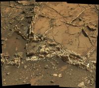
Posted by: xflare Mar 16 2015, 06:30 PM
We may be here a while  wow
wow
|
Posted by: Explorer1 Mar 16 2015, 06:44 PM
Wow indeed; that's paydirt (if we're still talking in terms of gold)!
Posted by: djellison Mar 16 2015, 08:07 PM
Extraordinary stuff!
|
Posted by: atomoid Mar 16 2015, 09:31 PM
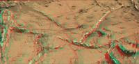
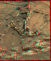
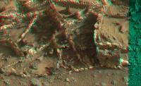
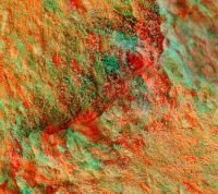
must be trying to steal the limelight from Oppy.. http://www.midnightplanets.com/web/MSL/image/00926/0926MR0040720050501734E01_DXXX.htmlanaglyph .. what happened here?
|
|
Posted by: atomoid Mar 17 2015, 12:31 AM
so much going on here, had to revisit the area to the left of above.. and portion in xeye form
|
|
Posted by: MarsInMyLifetime Mar 17 2015, 02:13 AM
Visible on the lower right of that last anaglyph rendering is a dimensional "bubble" of sorts that certainly has a hollowed aspect to it. And those boxy segments remind me of overhead views of Pueblo Bonito in New Mexico (http://arch.ced.berkeley.edu/kap/gallery/gal151.html). All around, this is an amazing place to be. And this is an amazing time to be witnessing all these outstanding and previously unseen views of so many distant worlds.
Posted by: nprev Mar 17 2015, 02:42 AM
Absolutely spectacular, surely to be one of the highlights of the entire mission.
Speaking as a COMPLETE amateur, this looks to me like extraordinarily powerful evidence of hydrothermal activity; finding silica would presumably clinch that interpretation.
Posted by: eliBonora Mar 17 2015, 07:36 PM
Our mosaic and anaglyph of this amazing angle!
https://flic.kr/p/rEv1Er
https://flic.kr/p/rCqjZW
and sol 926 mosaic:
https://flic.kr/p/rohbXM
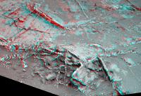
Posted by: Gerald Mar 17 2015, 10:17 PM
I wonder, whether the dark phase of the veins are (enriched in) hematite or other ores, and whether there may be a connection to Hematite Ridge, interpreting the veins as clastic dikes filling fractures with liquids of a later epoch, and precipitating minerals.
May be resolved later with data from younger layers.
Short-term I'm hoping for - almost expecting - interesting elemental enrichments in the veins, and possible detection of new types of minerals (for Mars).
Although I'm unsure, whether a new drilling will be approved so shortly after the previous drilling.
Posted by: jvandriel Mar 18 2015, 10:27 AM
The Mastcam R view on Sol 924.
Jan van Driel
|
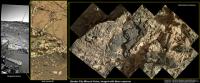
Posted by: PaulH51 Mar 18 2015, 12:25 PM
My take on the MastCam-R view of Garden City on Sol 924 (Raw)
|
Posted by: dvandorn Mar 18 2015, 05:46 PM
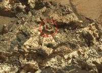
Interesting -- y'all remember those things Curiosity came across early on, that looked like popped mud bubbles that had frozen into stone?
Looks to me like this formation shows one of those bubbles as an erosional remnant in the uppermost layers of what has most effectively resisted erosion, circled in red in the attached detail.
I also see a lot of other little circular-to-spherical features in the remnant formation, here. Some might be the remains of small impacts, but others might well be the final remains of other of these "popped bubble" formations.
-the other Doug
|
Posted by: neo56 Mar 18 2015, 07:41 PM
Here is my take on stitching pictures of this amazing place.
Sol 924:
https://flic.kr/p/rFyRPX
Sol 925:
https://flic.kr/p/rFonkE
https://flic.kr/p/rnbVcH
Sol 926:
https://flic.kr/p/rEkrxQ
https://flic.kr/p/rFsVZx https://flic.kr/p/rFof9V
https://flic.kr/p/rm77ZM
Posted by: tdemko Mar 18 2015, 10:05 PM
The shape, orientation, and geometry of these fractures reminds me of terrestrial examples of seal failures due to hydrofracturing via overpressure. This is also supported by the observations that they occur in a rather thick massive to laminated mudstone interval and terminate in the overlying more permeable coarser-grained strata.
For the interested, this a nice accessible review article on the subject:
http://journal.frontiersin.org/article/10.3389/feart.2013.00004/full
For those less curious, here is a link to a nice photo from the article of the phenomena:
http://www.frontiersin.org/files/Articles/74145/feart-01-00004-HTML/image_m/feart-01-00004-g006.jpg
For those in the UK, the classic exposures at Kilve and Watchet in Somerset are worth a pilgrimage to see these phenomena in incredible beach cliff and wave-cut terrace exposures. Check a tide chart, if you do though!
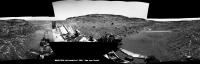
Posted by: jvandriel Mar 19 2015, 08:44 PM
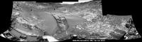
Here is the complete Navcam L panoramic view taken on Sol 926.
Jan van Driel
|
Posted by: jvandriel Mar 19 2015, 09:00 PM
Wheeltracks on Sol 928.
Jan van Driel
|
Posted by: jvandriel Mar 20 2015, 10:10 AM
MAHLI Panorama on Sol 930.
Jan van Driel
|
Posted by: Ron Hobbs Mar 20 2015, 02:26 PM
What a beautiful rock!!!

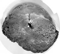
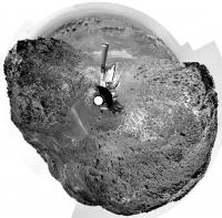
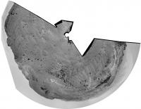
Posted by: Phil Stooke Mar 20 2015, 02:50 PM
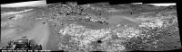
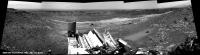
Jan's full panorama in circular format.
Phil
|
Posted by: eliBonora Mar 20 2015, 08:54 PM
Sol 930, some processing:
https://flic.kr/p/rHfkvK
https://flic.kr/p/rqPv3a
and anaglyph
https://flic.kr/p/qLtRUn
Posted by: serpens Mar 20 2015, 10:37 PM
Outstanding work Elizabeth.
Posted by: PaulH51 Mar 21 2015, 10:24 AM
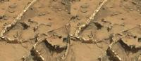
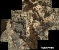
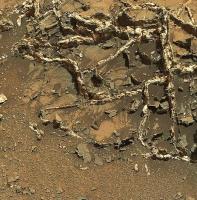
The Garden City mineral veins, rotated and shown in context
|
Links :-
https://www.flickr.com/photos/105796482@N04/16258719743/sizes/l/
https://www.flickr.com/photos/105796482@N04/16258719743/sizes/h/
https://www.flickr.com/photos/105796482@N04/16258719743/sizes/k/
https://www.flickr.com/photos/105796482@N04/16258719743/sizes/o/
Edit: Apologies, posted to wrong section, can mods please relocate the post?
Posted by: Gerald Mar 21 2015, 04:21 PM
http://mars.jpl.nasa.gov/msl-raw-images/msss/00930/mcam/0930MR0040900010501797E01_DXXX.jpg, probably of the Telegraph Peak drill powder.
This simplifies arm movements, e.g. for MAHLI wheel imaging, and opens an option for a next drilling.
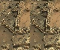
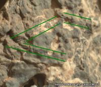
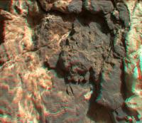
With respect to the Garden City MAHLIs, here an annotated crop of http://mars.jpl.nasa.gov/msl-raw-images/msss/00930/mhli/0930MH0004770010303180C00_DXXX.jpg:
|
With an interpretation of the darker phase as partially brecciated mudrock, having lithified a little faster than the light-toned fine-grained phase, I could get a more or less consistent view of the image. Both phases look rather resistant to erosion by considering the angularity of the surface; the darker phase maybe a little more resistant than the light-toned phase. Each of the two presumed phases may vary a bit in composition.
The part which doesn't like to fit easily into this interpretation are the parallel-looking features I've annotated by green lines.
Initially I've been looking for http://en.wikipedia.org/wiki/Cleavage_(crystal) to narrow down mineralogy, but instead found these linear structures, which don't seem to care too much about the remaining structuring of the rock.
Posted by: neo56 Mar 21 2015, 08:10 PM
My take on MAHLI close-up on those mineral veins. Images are corrected from artifact and color corrected:
https://flic.kr/p/rpJ2FR https://flic.kr/p/qMaPk5
https://flic.kr/p/rGT6D9
Posted by: tdemko Mar 21 2015, 09:55 PM
The features that Gerald has highlighted look like healed fractures; that is, fractures that formed by a propagating crack tip but were not subsequently propped open by fluid or precipitating mineralization. They would have closed, reversing the extensional, opening mode void. The cross-cutting relationships suggest that this was an earlier fracturing episode since they terminate against the mineralized fractures (veins). The fracture faces of these features seem to have been slightly mineralized (Gerald's parallel-looking features), making them a bit more resistant to erosion and stand out in relief.
Posted by: Gerald Mar 22 2015, 12:59 AM
That sounds plausible. Thanks a lot for helping over this hurdle!
Posted by: Floyd Mar 22 2015, 12:54 PM
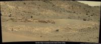
Mars is full of serendipity. You spend 6 months throughly exploring and studying a scientifically important area (Pahrump Hills), then hit the road and travel less than 100m before finding Garden City.
To explore Mars with less chance of driving by unseen treasures (just 100m away behind a hill or in the next canyon over), it would be nice to have a swarm or rovers or a rover with a drone scout 
Posted by: jvandriel Mar 22 2015, 02:24 PM
The MASTCAM R view on Sol 929.
Jan van Driel
|
Posted by: PaulH51 Mar 22 2015, 09:47 PM
Another take on the extended R-MastCam mosaic from sol 929. I tried to add the images from 926, but had stitching issues, working on resolving those (edit : link repaired)
https://flic.kr/p/qN2a4e
https://www.flickr.com/photos/105796482@N04/16273346823/sizes/l
https://www.flickr.com/photos/105796482@N04/16273346823/sizes/k/
https://www.flickr.com/photos/105796482@N04/16273346823/sizes/o/
|
Posted by: atomoid Mar 23 2015, 07:55 PM
whimsical wisp in foreground http://www.midnightplanets.com/web/MSL/image/00929/0929ML0040870240402859E01_DXXX.html
|
Posted by: Habukaz Mar 23 2015, 09:35 PM
Luckily, the http://www.jpl.nasa.gov/news/news.php?feature=4457 might just be on its way.

Posted by: Gerald Mar 26 2015, 11:05 AM
A (probably failed) attempt to find fluorescence in the Sol 935 MAHLI night shots:
Starting from this http://mars.jpl.nasa.gov/msl-raw-images/msss/00935/mhli/0935MH0004820020303337C00_DXXX.jpg, RGB channel-wise histo stretch returned this image:
http://imgur.com/L95m0mh
Starting from http://mars.jpl.nasa.gov/msl-raw-images/msss/00935/mhli/0935MH0004820060303341C00_DXXX.jpg, perliminary cleaning by subtracting a Sol 910 night image without LED returned this image
http://imgur.com/a8ZrV8H
then RGB channel-wise histo stretch returned this one:
http://imgur.com/OzbrhTG
Subtraction of the histo stretched white LED image from the cleaned and histo stretched uv LED image returned this image:
http://imgur.com/kSTFIyA
Histo stretch of the difference image returned this result:
http://imgur.com/TBstHL5
In the latter image I wasn't able to indentify fluorescence or phosphorescence uniquely.
Most variations are probably due to shadows and slightly different positions of the LEDs (my preliminary interpretation).
Posted by: Gerald Mar 26 2015, 05:52 PM
http://mars.jpl.nasa.gov/msl-raw-images/msss/00936/mhli/0936MH0004830050303406C00_DXXX.jpg(Sol 936) close to the complex Garden City vein seems to be very soft again (well-scratchable by the brush).
The rock contains grains (clusts, concretions,...) which appear harder (more erosion-resistant) than the matrix. The interior of the rock looks greyish relative to the rind.
Posted by: algorithm Mar 26 2015, 09:03 PM
The same brushed target as an anaglyph.
|
Posted by: algorithm Mar 26 2015, 09:21 PM
This is a really zoomed in crop, my brain/eyes can't make sense of anything any closer.
The detail is great, the only problem is that I can no longer focus on my keybooorf!!
|
Posted by: algorithm Mar 26 2015, 09:53 PM
Two more MAHLI images as an anaglyph, from Sol935
|
Posted by: Gerald Mar 26 2015, 10:10 PM
...
For left red, right blue, I'd say the channels should be exchanged.
Posted by: serpens Mar 26 2015, 10:33 PM
If this were an image from Earth I would be querying raindrop impressions. Not suggesting they are, just noting the similarity.
Posted by: Gerald Mar 27 2015, 10:11 AM
In the meanwhile the focus stacked version is available (anaglyph version) :
http://imgur.com/g1B9Ht4
Posted by: Gerald Mar 27 2015, 12:02 PM
http://mars.jpl.nasa.gov/msl/multimedia/raw/?rawid=0936MH0004810050303378C00_DXXX&s=936.
Here a version with the derived scale:
http://imgur.com/1laccAS
The size of the grains seems to be between about 0.5 and 1.0 mm.
There may be some fine layering.
My favorite interpretation would be a sandy mudstone/siltstone of fluvial (velocity about 30 cm/s) origin.
Posted by: neo56 Mar 27 2015, 07:53 PM
My turn to add a scale: I used the motor count of sol 930 MAHLI pictures to derive the scale for these mosaics of veins at Garden City:
https://flic.kr/p/rMnCCo
Posted by: Actionman Mar 27 2015, 09:24 PM
Any way you cut it the rock is black & white. Seems this area is a mantel breach of some type. The black rock being mantel basalt.
Posted by: Gerald Mar 28 2015, 12:58 AM
Basalt would be very surprising as a vein fill.
The http://en.wikipedia.org/wiki/Vein_%28geology%29 are probably the result of some kind of groundwater activity (fluids).
Transported or solved minerals have been precipitated in fractures, or even extended the fractures.
In a http://www.unmannedspaceflight.com/index.php?showtopic=7988&view=findpost&p=218956 T. Demko provided a link to very detailed explanations.
Posted by: atomoid Mar 30 2015, 09:19 PM
resistant fill patch and dune xeyes http://www.midnightplanets.com/web/MSL/image/00940/NRB_480948797EDR_F0450996NCAM00354M_.html
|
|
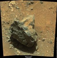
Posted by: PaulH51 Mar 31 2015, 11:05 AM
R-Mastcam mosaic of the sol 940 target "Kanosh"
https://www.flickr.com/photos/105796482@N04/16800030640/sizes/k/
Edited
|
Posted by: Gerald Mar 31 2015, 01:18 PM
Cap rock "Kanosh" Sol 940, Mastcam L/R, x-eyed, and anaglyph version:
http://imgur.com/BPaLJl5 http://imgur.com/GuU86WG
Posted by: atomoid Mar 31 2015, 09:27 PM
interesting little 'http://www.midnightplanets.com/web/MSL/image/00940/0940MR0041320090501939E01_DXXX.html' at the bottom of the image here, theres no parellax betweent he two http://www.midnightplanets.com/web/MSL/image/00940/0940MR0041320080501938E01_DXXX.html, and the m34 doesnt provide enough resolution in the second crosseye, nonetheless it does seem to be half embedded in and thus eroded out of the rock (outcrop?) at its left, as opposed to being a segment of cleanly detached fill vein as if jetsam from Kanosh.
|
|
Posted by: PaulH51 Mar 31 2015, 11:41 PM
A better look down Artist's Drive. Sol 940, left mast camera.
https://www.flickr.com/photos/105796482@N04/16994259855/sizes/h/
Also a possible return to Garden City : http://astrogeology.usgs.gov/news/astrogeology/sols-942-943-cap-rock-kanosh-
Posted by: jvandriel Apr 1 2015, 08:20 AM
The road ahead.
The Navcam L view on Sol 942.
Jan van Driel
|
Posted by: jvandriel Apr 1 2015, 09:15 AM
Nice view.
MAHLI looking at the wheels and down on Sol 939.
Jan van Driel
|
Posted by: neo56 Apr 1 2015, 06:13 PM
A rock of Garden City imaged with MAHLI on sol 937:
https://flic.kr/p/rBL5LJ
Posted by: PaulH51 Apr 1 2015, 11:45 PM
MAHLI close-up of Kanosh on sol 942 (red/cyan anaglyph)
https://www.flickr.com/photos/105796482@N04/16818098389/sizes/l
Posted by: PaulH51 Apr 2 2015, 06:24 AM
4-image, R-MastCam Mosaic : Looking deeper into Artist's Drive (Sol 942)
https://www.flickr.com/photos/105796482@N04/16819226728/sizes/k/
Posted by: jvandriel Apr 2 2015, 12:28 PM
The complete Navcam L Panoramic view on Sol 940.
Jan van Driel
|
Posted by: Gerald Apr 2 2015, 04:08 PM
The decision has been made:
http://astrogeology.usgs.gov/news/astrogeology/sols-944-945-return-to-garden-city
Posted by: Phil Stooke Apr 2 2015, 04:57 PM
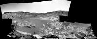
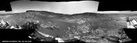
Jan's sol 940 panorama in circular form - it shows the path through the valley quite clearly, and the view back to Pahrump Hills..
Phil
|
Posted by: algorithm Apr 3 2015, 06:52 PM
A NavCam anaglyph of the Garden City, Sol 944
|
Here in England, we've had garden cities since 1898, http://en.wikipedia.org/wiki/Garden_city_movement, I think this pre-dates that though,

Posted by: jvandriel Apr 4 2015, 02:06 PM
Back at Garden City.
The Navcam L view on Sol 944.
Jan van Driel
|
Posted by: PaulH51 Apr 5 2015, 11:22 AM
6 image mast camera mosaic of the extended veins at Garden City, images acquired after the drive during sol 944 (April 03, 2015
https://www.flickr.com/photos/105796482@N04/16832828647/sizes/h/
Contrast marginally stretched to highlight the different surface materials.
Posted by: PaulH51 Apr 5 2015, 11:19 PM
A section of the mineral filled veins at Garden City acquired on sol 946 (9 MAHLI frames) EDIT : Additional frame added (now 10 MAHLI frames) and roughly stitched and rotated to provide a little context with some earlier mast camera images (sol 929)
https://www.flickr.com/photos/105796482@N04/16859884210/sizes/h/....https://www.flickr.com/photos/105796482@N04/16861485368/sizes/h/
Posted by: serpens Apr 6 2015, 12:10 AM
Nicely done Paul. A consensus seems to be forming that the veins seen here and at Sheepbed represent hydraulic fracture fill. This indicates that the mudstone must have been covered to depth certainly no less than a kilometre and probably much more. But it also implies that there would be a significant thickness of sediment below the mudstone which compacted to provide the high pressure solution necessary to fracture the mudstone cap and form the fracture fill. This means that the basal unit could be much deeper than suggested by Anderson and Bell in their outstanding landing site selection paper.
Posted by: PaulH51 Apr 6 2015, 05:15 AM
Thanks Serpens. Earlier I was studying the mineral layering in this http://mars.jpl.nasa.gov/msl-raw-images/msss/00946/mhli/0946MH0004900000303882R00_DXXX.jpg and noting the amount of separate mineral veins. I can not even begin to imagine how long these took to form, but now I can begin to appreciate why they decided to return to this location to gather more data before heading towards the mountain once again.
Posted by: serpens Apr 6 2015, 07:34 AM
Yeah, I can see why they want more mineralogy and it will be interesting to get the take of the experts. I don't know if it is just my deranged imagination but there seems to be a couple of examples of sigmoidal fracture fill in your image at post #76 which could imply rotation of segments of mudstone. The thicker white fracture fill which I assume is the ubiquitous calcium sulphate could imply hydration of anhydrite to gypsum which gives a hefty increase in volume.
Posted by: PaulH51 Apr 6 2015, 08:18 AM
This small R-MastCam mosaic may help you decide if one of those areas is a sigmoidal fracture fill, differential erosion, or something else entirely
https://www.flickr.com/photos/105796482@N04/17025710906/sizes/h/
This is certainly an interesting location, whatever these features are
Posted by: craigmcg Apr 6 2015, 11:21 AM
While following this thread, I saw this come by my news feed. Visually similar to my non-geologist eye.
http://www.dpreview.com/galleries/3065032146/photos/52326/sunset-colors-death-valley?inalbum=death-valley
Posted by: serpens Apr 6 2015, 12:17 PM
I was thinking more along the lines of the "S" and "C" structures here.
|
Posted by: PaulH51 Apr 6 2015, 12:51 PM
OK
I'll watch out for any R-MastCam images that may help.
Posted by: eliBonora Apr 6 2015, 05:38 PM
Some of our latest processing
sol 938 anaglyph
https://flic.kr/p/rY2taf
wheels sol 939
https://flic.kr/p/rRjCwP
Kanosh anaglyph sol 940
https://flic.kr/p/rRgMxL
and some more vivid MAHLI sol 942
https://flic.kr/p/rVSha3
https://flic.kr/p/r2n7kk
https://flic.kr/p/rVSgEL
@PaulH51 nice composition!
Posted by: Mr. Bergstrom Apr 6 2015, 08:41 PM
craigmcg, thank you for uploading that photo. Has helped me put it into a Terran context. Have similar geological processes produced what we're seeing at Garden City?
PaulH51, 'A Puzzle For The Geologists' wow pretty impressive mosaic, how long did it take you to do? Were the images literally taken from the raw images page on NASA's site here http://marsmobile.jpl.nasa.gov/msl/multimedia/raw/?s=#/?slide=946 , and then stitched together by yourself? Loved it anyway!
Posted by: tdemko Apr 6 2015, 11:11 PM
Yes, the source of the overpressure that resulted in the brittle tensile failure of the mudstone is where my curiosity(!) lies. An authigenic or mineralogic volume increase, as you've stated, could certainly be a good candidate, especially when dealing with anhydrous and hydrated sulphate minerals. Hydrated clays also can exhibit significant volume changes as water is added and lost from their crystal lattice. Deep burial, on its own, should not cause this type of feature. Deep burial followed by quick exhumation, on the other hand, can do this, in the presence of isolated pressure cells (here the sandstone and mudstone strata). Other terrestrial causes include biogenic and thermogenic hydrocarbon generation, although when this happens at deepest burial, horizontal, rather than vertical tensile fractures can form (the famous "beef" veins of the Yorkshire, Dorset, and Somerset Jurassic exposures). It is interesting that you are seeing sigmoidal fractures and C-S features, suggesting some horizontal stress and shear in addition to the burial/vertical/lithostatic stress. In terrestrial fracture fills associated with overpressure, calcite crystallizes in veins as a distinctive cone-in-cone fabric when there is a component of horizontal stress, rather than the prismatatic, fracture-spanning "beef" fabric associated with overcoming lithostatic stress (nice review article, behind a paywall, http://www.sciencedirect.com/science/article/pii/S0264817213000299).
The go-to analyses to really determine the source of the overpressure involve determining the phase/PT behavior and composition of fluid inclusions in the fracture fill minerals. Certainly would be candidates for caching for a possible sample return, or reason for including such instrumentation on a future landed mission.
Posted by: tdemko Apr 6 2015, 11:25 PM
Deep burial and exhumation could be due to filling of accommodation followed by landscape degradation via erosion, or growth and decay of a thick ice sheet.
(sorry for the additional post, but...I'm a Member!...finally!...100 posts!...it only took 11 years!)
Posted by: PaulH51 Apr 6 2015, 11:59 PM
Yes, less than a minute to stitch the raw images using "Microsoft Image Composite Editor" (ICE) http://research.microsoft.com/en-us/um/redmond/projects/ice/ I use an older version V1.4.4.0 which I prefer to V2.0. There are many better tools, but this one works for me. PhotoScape then used to add the annotations etc. There is a thread for http://www.unmannedspaceflight.com/index.php?showtopic=7418&pid=218826&st=465&#entry218826 Kindly use that thread if you have any other queries re MS ICE, plus there is a host of great material there worth studying
Posted by: PaulH51 Apr 7 2015, 01:47 AM
One of the many ChemCam-RMI targets acquired in recent days. Shown here in context with its location at Garden City.
Roughly stacked and converted to a red/cyan anaglyph
https://www.flickr.com/photos/105796482@N04/17060502471/sizes/l
Posted by: PaulH51 Apr 7 2015, 12:46 PM
Evidence of laser strikes observed on a ChemCam target on the last planned full day of science at Garden City (sol 948)
https://flic.kr/p/rXLMdd
Posted by: jvandriel Apr 7 2015, 02:18 PM
The last images are down and here is the complete Navcam L Panorama
taken on Sol 944.
Jan van Driel
|
|
Posted by: PaulH51 Apr 8 2015, 03:57 AM
Another section of the Garden City mineral filled veins captured by Curiosity on sol 948.
EDIT : Added another 7 frames (total = 14) There is a lot of overlap with the first mosaic, but the additional frames finish it off well
https://www.flickr.com/photos/105796482@N04/17073683535/sizes/k/ . . . .https://www.flickr.com/photos/105796482@N04/16875605777/sizes/o/
Scale bar added
Posted by: jvandriel Apr 8 2015, 08:51 AM
Curiosity looking back on Sol 944.
Jan van Driel
|
Posted by: TheAnt Apr 8 2015, 08:58 AM
(sorry for the additional post, but...I'm a Member!...finally!...100 posts!...it only took 11 years!)
Congrats to the 100 then, yet better with quality over quantity. =)
Thank you for your thoughts on this site, and I think you nailed it with your second post there. I have a hunch that what we see is the result of both mechanical stress and erosion and pressure that happened during one ice epoch. Like craigmcg I have also seen something similar in sandstone with mineral veins of calcium, where the the last ice age is thought to have removed part of the sandstone. I am going to work outdoors in the coming weeks, if I pass by of one of the two sites where its found I might snap a picture and post one Earth comparison image here. =)
Posted by: Gerald Apr 8 2015, 01:10 PM
Sol 949 NRB pano, after a drive, http://astrogeology.usgs.gov/news/astrogeology/sol-949-leaving-garden-city:
http://imgur.com/rNNHssK
Posted by: jvandriel Apr 8 2015, 02:04 PM
Here is my view of the Navcam L panoramic view on Sol 949.
Jan van Driel
|
Posted by: Phil Stooke Apr 8 2015, 02:50 PM
Thanks, Jan and Gerald, for your panoramas. I made a composite of the two (to clean up the view of the valley behind us) and made a circular version. We get a good view along the valley from here.
Phil

|
Posted by: jvandriel Apr 9 2015, 09:45 AM
Partial Navcam L Panoramic view on Sol 950.
The rest of the images will be added when they are down.
Jan van Driel
|
|
Posted by: Ant103 Apr 9 2015, 12:12 PM
Welcome everyone
Looong time no panoramic stitching. I prefer to keep my own tempo on it
So, I feel like to made the stitching of the last Sol 949 Navcam pan, and maybe Sol 950 will come.
http://www.db-prods.net/marsroversimages/Curiosity/2015/Sol949_pano.jpg
Posted by: tdemko Apr 9 2015, 12:35 PM
The close-up mosaic posted by PaullH1 reveals some fascinating details. The vein fills are complex, multi-generation features with evidence of several or repeated tensile fracturing events. There are anastomosing, en echelon, and hair-like network veins of several different mineral phases paired on either side of the center of the fracture. These are called stacked veins. The dark material seems to me to be mudstone country rock that was trapped between these sub-veins and subject to metasomatic alteration. When rocks are fractured in a tensile fashion, one possible result is the polygonal-to-crazed pattern we see at the exposure. The dominantly opening-mode dilation (with some evidence of slight shear) was filled by precipitation of minerals, presumably from the fluids that provided the hydraulic force that drove the crack tip propagation. Once rocks are fractured and veins emplaced, these discontinuities in the rock volume act as planes of weakness which localize subsequent brittle deformation. In general, the vein-host rock boundary is about half as strong (resistant to breakage when subject to the same stresses again) as the unfractured host rock. The relative strengths of the vein fill versus the altered and unaltered host rock controls the subsequent fracture morphology. If the vein material breaks first, a crack-seal pattern is the result, and there are mirrored pairs of older vein material split by the new fracture and filled with younger vein material. If the vein material is stronger than the host rock, the crack propagates in crazed fashion along the boundary, creating a crack-jump pattern, and the radiating/horse-tail hair-like fractures and veins. The crack can also deflect in and out of the host rock as it propagates along the interface, and the result are slices and slivers of host rock incorporated into the vein stack.
Although this http://onlinelibrary.wiley.com/doi/10.1002/2013JB010540/abstract (should be publicly available) concerns modeling of fractures and veins, it also has a nice summary and some illustrations of these concepts.
I'd also like to delicately point out that these fractures and veins show abundant evidence of formation and implacement at depth, in the subsurface. Although superficially similar to surficial features like mudcracks and polygonal fractures due to evaporite precipitation, the evidence points to a hydraulic fracturing origin and failure via overpressure or pressure differential.
Posted by: Phil Stooke Apr 9 2015, 01:32 PM
Very pleased to see Ant103 back with us! For the 950 drive, here is the circular pan (from Jan's post, still missing a couple of frames) I used for locating the site on my map.
Phil

|
PS from tdemko's post above: " the evidence points to a hydraulic fracturing origin" - yikes, they're fracking on Mars now! Hope it doesn't mess up the groundwater.
Posted by: Dig Apr 9 2015, 05:32 PM
Hello again Damia,
I also took a long time without posting any new panorama and was thinking maybe post some.
I think it makes little sense to publish all the same scene three or four times.
Jan is doing a good job and fast, very fast.
Posted by: Arizona Dave Apr 9 2015, 05:48 PM
Regarding the veins and the fractures, the thing Im trying to understand is this:
These vein outcrops occur near the lower elevations of this large crater, Mt Sharp and the Rims being anywhere form 2 to 3.5 miles higher in elevation. Its now widely accepted that where Curiosity is exploring was under water far longer than previously estimated, and then that water slowly evaporated, leaving behind layered sedimentary rock layers and other tell-tale signs of long periods of a "shallow sea".
So, if these veins are the result of minerals precipitating under high pressure, then this would mean these veins formed under Several Kilometers of overburden...and now they are been exposed due to "erosion" the questions are:
a) Being near the bottom of Gale crate, rather than the top, where did the KM's of rock and overburden erode to? Erosion goes downhill, there isnt anywhere for KM's to have eroded to, The crater prevents excavation of sediment outside of the rim (thus all erosion remains inside the crater) - and There is clear evidence of surface water at this location, and that it was under water at different shallow depths for perhaps billions of years...so, that situation in effect negates the overburden hypothesis, because again, the surface water action evidence is side-by-side with the veins.
Is it more possible this is non-pressure related, and more ancient heat/hydrothermal in nature?
If we accept Mars has been pretty dry for the last Billion years, then we are seeing something that had been roughly the same for a billion years...those flaky paper-thin wafer of rock resting in position where they are well above the surface show the wind load isnt enough to move them...so certainly not KM of overburden were removed simply by wind.
Im thinking Non Terrestrial erosion and mineralization mechanisms need to be considered...Mars has no Techtonic plates, and less water no matter how long it existing, and 2/5th the gravity, meaning erosion forces far less than earth...
Id love to hear some thesis on how these veins are so near the surface - thx.
Posted by: erwan Apr 9 2015, 06:26 PM
Superbe Damia ! Et cela fait plaisir.
Posted by: jvandriel Apr 9 2015, 06:54 PM
The Mastcam L view on Sol 949.
Jan van Driel
|
|
Posted by: centsworth_II Apr 9 2015, 06:56 PM
Barring an error in my quick math, an average of 1mm removed per 100 years will lead to 10 km removed in a billion years.
Posted by: Arizona Dave Apr 9 2015, 07:19 PM
Yes, mathematically thats correct, but "Where" did the material go?
a) Not all overburden is "dust/sand" at least 50% of overburden would be hard rock and thus at least 50% of that overburden could not be moved by wind, thus it cannot be located outside of the crated, rocks dont roll uphill.
Where does the 1mm/year data come from? 1mm/yr is a HUGE amount of material, and 1mm/yr assume 100% of that 1mm/yr was removed from the crater and deposited somewhere else...this brings up another interesting question: Does dust and sand only get removed from the crated to higher areas, or does dust also get blown in from outside the crater and deposited to Lower areas (dust and sand usually settles to lower/depressed areas over time)c) WHERE did 1mm per year go? Only outside the crater?
d) at 1% of the earth's atmosphere, 100mph winds on mars would exert the force of a 1mph wind on earth...living in AZ for 20 years, dust storms simply dont happen in winds under 30-40 mph, and we certainly dont get 1mm of dust/sand per year removed or deposited in AZ...The dust in Mar's atmosphere is very fine dust, due to the lack of air compared to earth, so what mechanism not only eroded, but excavated all that material to Only Outside the crater?
Gale Crater itself is known to be as old or older than the sea/lake that they now know existed there. Mars' entire geology is entirely different than Earths...craters since almost he beginning of its forming still exist...while 99% of Earths craters and been sublimated via Plate Tectonics, and mass erosion.
Im really asking as serious question here, I dont see the mechanism to not only erode, but then Move the Kilometers of material away...not only that, but the clear signs of surface water, with the Veins Fracturing those surface water features means that the veins formed After? the water was lost, or at least When the Water was there...this them means Kilometers of Overburden were not only Deposited over the area to create the pressures required to form them, but then subsequently that same material was removed...
It had to come from somewhere and then it had to go somewhere...Or, the veins were formed under Low pressure/Surface conditions.
I think its absolutely fascinating whatever they are and however they formed...The paper thin wafer pieces all over are especially intriguing. Viewing these images in Streoscopic makes 2D photos seem bland.
Posted by: Arizona Dave Apr 9 2015, 08:03 PM
On a little diff note:
Has anyone else noticed the lack of new full-res Raw images of late? Seems like they were putting up 20-40+ MAHLI and even more Pano full-res images until they hit Garden City...
I wonder if this because they are not taking as many pics, or something else?
Posted by: ngunn Apr 9 2015, 08:04 PM
Well, perhaps some of the overburden could have been ice. Ice can 'erode' uphill - and in the case of Mars just keeps going that way.
Posted by: mcaplinger Apr 9 2015, 08:11 PM
What do you mean by "full-res" and "raw"? Mastcam and MAHLI have no summing modes so all images are "full-res" technically. You can't tell the difference between lossless and JPEG return with MAHLI. Returning losslessly-compressed Mastcam images seems to have tailed off, is that what you mean? There are different users of Mastcam data and some would rather take more lossy images, some fewer lossless.
Posted by: centsworth_II Apr 9 2015, 08:19 PM
Posted by: Floyd Apr 9 2015, 10:19 PM
Arizona Dave-
On Earth erosion is mostly by water and stuff goes down hill. On Mars erosion (the last 3 billion years or so) is mostly by wind. Over this time frame, rocks break down to dust and wind carries it off, sometimes even from the bottoms of craters.
Posted by: Arizona Dave Apr 9 2015, 10:45 PM
KM's of Ice certainly could produce the pressure necessary, but the issue with that is that the veins and fractures are through old pre-existing mudstone etc...the waters that formed many of the features has been evaluated to have come from "shallow" sea/lake...that lake then evaporated (over many repeated wet/dry periods over millions of years), so once the lake dried up, where did the water come from to form KM's deep of ice? Mars never had enough water to cover the entire surface, and so if it caem from millions of years worth of snow, why did the snow pile up there KMs deep? The Snow could not have accumulated over the entire surface KM's because there wasnt enough water...especially after the lakes and seas started drying.
Im just trying to build a picture of how that process looks, without Plate tectonics, the original Oceans/seas and lower elevations of Mars have essentially stayed the same for billions of years..Earth meanwhile has drastically changed continents and oceans in just the past 500 million years.
Is it possible there was some other geothermal process that could have caused these, maybe they are not even that old...possibly they are new compared to the exposed mudstones and layered sedimentary rocks?
Just throwing out some ideas, outside the box a little.
Posted by: Arizona Dave Apr 9 2015, 10:57 PM
On Earth erosion is mostly by water and stuff goes down hill. On Mars erosion (the last 3 billion years or so) is mostly by wind. Over this time frame, rocks break down to dust and wind carries it off, sometimes even from the bottoms of craters.
True, current erosion on mars is caused by wind, more specifically dust particles carried by the wind basically sand-blasting other rocks.
The atmosphere being 1% has 1/100th the force of the wind on earth, there is no way around this. While on earth, winds can move pebbles and chunks of wood and blow over buildings at 100 and 200 and even 300 mph winds, on mars 300 mph wind will have the force to move what a 3mph wind on earth can move...perhaps 7 or 8 mph due to the gravitational weakness. So...on mars a 300 mph wind can move particles with as much force as an 8mph wind on earth, or move particles 1/100th the size at the same speed as winds on earth. Any way we cut it, wind erosion on mars is 1/100th what it would be on earth.
If KMs of material have been literally pulverized into talcum-powder dust by wind in Gale crater alone, and then transported, we should expect almost every KM+ tall feature on Mars to have been likewise blasted to dust (Mt Sharp for example), and dust layers of several KM deep covering almost the entire surface...what we see is quite drastically different. So why would the martian wind pick the lowest level of Gale Crate to blast into dust and export away while leaving Mt Sharp alone? We need a full process, not just one portion of it.
Needless to say, not all rocks get blasted away into dust...the dust blowing against a rock would need to be harder than the rock itself...we dont see a rock pile in Gale Crater, we see Bedrock features with boulders littered around...did 99.9% of the KM deep overburden really get sand-blasted while everything else remained intact?
Did Gale Crater happen AFTER the veins were formed deep underground, and exposed them from the impact, and then shallow seas filled Gale Crater? Or again, formed from other near-surface geologic process?
Posted by: Arizona Dave Apr 9 2015, 11:14 PM
Again, and not trying to argue, but scientifically speaking, how does 1mm per year get eroded? I have a stucco house, and I have 2" thick soft-concrete pavers for sidewalks, the house is 35 yrs old, the stucco is 1-1/2" thick, or 38mm...in 35 years the stucco has not eroded away, neither have my pavers which get hammered with AZ sandstorms, HEAVY rain laced with Sand and dust, etc. Simply put, rocks dont erode in a 1% atmosphere at 1 mm per year. Not even .1 mm per year. Water, when dripping on stone can "drill holes" over hundreds/thousands of years.
Now imagine an almost vacuum...where it takes 300mph wind to move grains of sand...but 300mph on mars happens how often? Its not as if there is a constant 100-300 mph wind on mars...thus how "Often" do "Erosional" event take place on Mars? Specifically at Gale Crate? 2 times, 10 time per year...then work that into the formula, and again, that is assuming that is the only mechanism...
So, again, if we accept the wind erosion theory, we must apply it over large portions of the Martian surface, and we need to find all that dust...KMs deep of it over large portions of the planet...what we see is opposite...scattered dunes, many with heavy grained sand, and LOTS of boulder and exposed bedrocks...Sririt, Opportunity and Curiosity all show this. HiRise and MRI images show this...we simply dont see a decimated planet covered in deep dust. We see dust storms, and dust accumulated on the rover...talcum fine dust. If wind erodes KMs deep of material on Mars, then we would find that accumulations of dust.
Also...NASA is now saying Gale Crated may have had water up until 1.5 or even 1B yrs ago...not 3.5B years...this would drastically change things as well.
So, Mars again...even if the overburden did erode away, why was did it selectively do so? Why Not eroded away entire Mt Sharp? Shat about all the Hard Rocks that must have been harder than the wind blown
Posted by: Arizona Dave Apr 9 2015, 11:30 PM
Here is the site I am accessing for images, maybe there is a better one? http://mars.jpl.nasa.gov/msl/multimedia/raw/index.cfm
A great majority of images on those links in the past 2 weeks have been thumbnails...before that a lot of the images were large...Im just hoping the rover isnt having problems...I know the wheels are deteriorating.
How far will this thing make it up Mt Sharp, or are they going to stay in the low-land valleys and alleys?
Posted by: Arizona Dave Apr 9 2015, 11:34 PM
Re-looking at what you said, maybe your suggesting its possible KM's worth of loose overburden was deposited over areas of Gale Crate, and then subsequently blown away ??
Interesting idea...also tilt of Mars Axis over time causing major wind patterns to change.
Also, I misread your 1mm relation...I read "per year", not 100 yrs...my apologies.
Posted by: djellison Apr 10 2015, 12:05 AM
Interesting idea...
That is the prevailing hypothesis regarding the formation of Gale at this time.
Posted by: elakdawalla Apr 10 2015, 12:12 AM
Thumbnails are always sent down first. High-priority images necessary for planning are returned at full resolution very quickly, but science images may wait days or months (sometimes many months) before transmission. We are edging closer to conjunction and MRO was in safe mode last week, so there's a bit of a bottleneck with data transmission at the moment. Eventually, most of those thumbnails will be upgraded to full-res images.
The condition of the wheels (which has not been deteriorating rapidly) has nothing to do with imaging or data return.
Posted by: serpens Apr 10 2015, 12:42 AM
Currently the environment on Mars is extremely benign but it would be a little silly to assess the formation of the current Mount Sharp topography based on current conditions. Gale is assessed to be between 3.6 to 4.1 billion years old and we know from Curiosity that when the areas she has traversed were laid down there was abundant surface water. Subaerial, not under ice. Looking at Mount Sharp we also know that the lower levels were water influenced and that following Mr Steno's wisdom, the layers should have covered the erosional end state explored by Curiosity to a significant depth. Lakes in Gale would possibly have been episodic but it would seem reasonable to assume that the formation of the lower layers of Mount Sharp occurred over a reasonably short geological timeframe. The increasing sulphates in the layers implies a change to an acidic, volcanic influenced environment and while as you say, Mars probably never developed tectonic plates, the formation of the Tharsis Bulge would have given the planet a real shakeup. If there was a northern ocean the effect on it would have been significant.
With respect to the veining, ice may or may not have provided a degree of compression and relaxation but given Tim Demko's indication that the fracturing and fill occurred at depth authigenic /mineralogic volume increases is probably the most likely cause of the veins, both here and also the larger examples higher up the mountain. Centsworth II gave a pretty fair indication of the cumulative effect of really minimal erosion over billions of year. Now extend that thinking to more rapid cycles of erosion and deposition in a reasonably high energy environment with the level of energy decreasing over billions of years until we get to the situation we see today. The upper, pretty much unconsolidated section of the mountain seems to reflect Kite's valley wind deposition concept but the lower levels, and Opportunity's observations, confirm lacustrine/fluvial deposition.
Where did all the eroded material go? Some contributed to the upper level of Mount Sharp. Since Gale is on the edge of the dichotomy much probably followed the gravitational gradient towards the northern lowlands.
Posted by: Arizona Dave Apr 10 2015, 05:25 AM
I have to admit, the time period involved with the known parameters would offset other arguments against hard erosion...This still presents some really interesting scenarios, because the fractures occur in pre-existing water-based bedrock...this means whatever process formed the veins had to involve water/hydrothermal processes under extreme pressure after that layer was originally formed, so now we are talking active processes happening after the base sea/lake evaporated, and the time involved in the deposition of overburden, and the "recent" wind-erosion.
In other words, in the last 30-25% of Mars' life, active geological (non weather-related) processes have been occurring!! So, the water that precipitated the mineralization was after the seas/lake dried up...
And perhaps 1/2B yrs ago, the atmosphere was far greater than current...plus NASA is saying water seas may have existed up until 1 to 1.2B yrs ago...a huge factor.
Whats next? its truly awe-inspiring what images we are getting, and in stereo-scopic is when the magic happens...I feel bad for ppl who cant see the stereoscopes...they are seeing a fraction of the overall scene. I tried describing it to a few ppl...they didnt "get" how much the veins and features are elevated above the surrounding material, 2D images just dont do it justice.
very cool indeed!
Posted by: Arizona Dave Apr 10 2015, 05:50 AM
The condition of the wheels (which has not been deteriorating rapidly) has nothing to do with imaging or data return.
Safe Mode answers most of my question, thank you. Do you have a link to the data that states the current/recent past status of curiosity? Ive looked and tried, and found nothing, its probably in plain sight and Im not seeing it...like most of the online bill paying portals lol :-)
Posted by: neo56 Apr 10 2015, 09:09 AM
Back to sol 942, I made a composite of two successive zooms on the surface of Kanosh rock by MAHLI camera (with scale):
https://flic.kr/p/r6YGST
Posted by: PaulH51 Apr 10 2015, 09:47 AM
My take on the sol 950 'drive direction' left mast camera mosaic (roughly stitched)
https://www.flickr.com/photos/105796482@N04/16909163468/sizes/k/
Posted by: Dig Apr 10 2015, 10:34 AM
My return to UMSF.
Left Navcam Sol 950 Full Resolution.
http://bit.ly/1PrEYE7
Click image for full resolution.
http://bit.ly/1jvdOKg
Posted by: Ant103 Apr 10 2015, 10:40 AM
Sol 950 Navcam panoramic.
http://www.db-prods.net/marsroversimages/Curiosity/2015/Sol950_pano.jpg
Posted by: PaulH51 Apr 10 2015, 11:31 AM
USGS Curiosity Mission Update for http://astrogeology.usgs.gov/news/astrogeology/sol-951-10k (today) "10k" by Ryan Anderson.
Posted by: Dig Apr 10 2015, 01:43 PM
To do something different.
Left Navcam and Left Mastcam (M-34) in single panorama.
http://bit.ly/1DPA8xu
Click image for full resolution.
http://bit.ly/1jvdOKg
Posted by: hendric Apr 10 2015, 03:49 PM
Deposition can go uphill. It's entirely possible that lower altitudes erode more because of thicker atmosphere, and the dust ends up at higher altitudes because the atmosphere cannot keep it afloat any more and the atmosphere cannot erode as effectively at altitude. Or the erosion at low altitudes puts dust into the air that ends up entrained in ice somewhere else. Larger grains are probably all local, but once they reach a size that they can be distributed via dust storms, they end up globally distributed.
d) at 1% of the earth's atmosphere, 100mph winds on mars would exert the force of a 1mph wind on earth...living in AZ for 20 years, dust storms simply dont happen in winds under 30-40 mph, and we certainly dont get 1mm of dust/sand per year removed or deposited in AZ...The dust in Mar's atmosphere is very fine dust, due to the lack of air compared to earth, so what mechanism not only eroded, but excavated all that material to Only Outside the crater?
Where is the 50% rock/dust number coming from?
I think the dryness on Mars allows for much finer dust - Az is a wet tropical paradise compared to the amount of water in the air on Mars. Also, moisture on Earth limits the minimum size of dust before it starts sticking together and falling out of the sky. The extreme dryness of Mars' atmosphere prevents small dust particles from cementing together.
http://en.wikipedia.org/wiki/Martian_soil#Atmospheric_dust
"Hard rock" I would guess is only true for the source basalts - once they have eroded into dust, and turned into sedimentary layers, I expect they are much softer than corresponding rock on Earth, due to lower gravity not compressing them as much and generally not as much water to cement grains together.
Topology of the crater could have influenced how the material interior hardened and was eroded away. It could affect where and how much water percolated upwards through the cracks generated by the impact, the size distribution of the dust depositions due to the initial crater walls and original central peak, and how wind erosion swirled around the crater. With the higher southern wall, it seems to me that winds blowing north would swirl over the wall, and erode the interior to the south of the central peak pretty effectively. I don't know if that's a prevailing direction of wind over the last 1Gy, but it would help explain why it looks that way.
Don't forget our view of Mars is a small snapshot in time of a very dynamic climatic system - with the huge axial tilt variability allowing for "permanent" ice caps at the equator. Lecture 1.20 gives an overview of what to expect over the range of axial tilts on Mars:
https://class.coursera.org/solarsystem-002/lecture
Having large ice caps at the equator probably causes some pretty intense & strange winds.
Posted by: Arizona Dave Apr 10 2015, 04:55 PM
Ice Caps at the equator would indeed have extreme impacts on weather/climate...Thats a very interesting concept, and although I knew about its extreme changes in axism I never put 2 and 2 together...I wonder if the axis precession over the eons could also be a source of the "mass flooding" event that there is evidence of in so many of the different areas of Mars.
I just hope Curiosities wheels dont give out before it makes some more stunning discoveries like those veins...those things and the other features around them are awesome!
Thank you and everyone for patience...I really was trying to get a mental picture of the erosion processes, and now I do..maybe they are right, maybe something else, but definitely those ideas address the differences between terrestrial and martian erosion.
Also, someone else posted a link regarding Curiosities daily plan - THANK YOU! :-)
Posted by: Ant103 Apr 10 2015, 05:05 PM
How about a colorized version of the Sol 950 panorama ?
Here we go
http://www.db-prods.net/blog/2015/04/10/artists-drive-a-sol-950-colorized-postcard/
Posted by: Phil Stooke Apr 10 2015, 05:42 PM
Nobody does that as well as you, Damia!
Phil
Posted by: Dig Apr 10 2015, 05:46 PM
Excellent, Damia!
Posted by: Phil Stooke Apr 10 2015, 05:59 PM
Just a word to our panorama compilers here. I love you all! You might think the duplication is unnecessary, and I'm not trying to over-burden the server... but every one is different - maybe left versus right cameras, or slight variations in geometry (try overlaying two apparently identical pans... they vary much more than you might think). So I personally am very pleased to see more than one version of a panorama. Then, of course, there are other ways of adding value: the Mastcam color overlay is nice, the full colorization is nice, highlighting ChemCam RMI targets might be another interesting addition.
Phil
Posted by: charborob Apr 10 2015, 06:06 PM
Sol 951 navcam anaglyph of the curved outcrop that Phil Stooke referred to in the route map thread:

|
Posted by: jvandriel Apr 10 2015, 08:06 PM
The Navcam L partial panoramic view on Sol 951.
Jan van Driel
|
|
Posted by: Phil Stooke Apr 10 2015, 08:28 PM
Great! Here's a quick circular view to match with the map.
Phil

|
Posted by: Floyd Apr 10 2015, 08:45 PM
So will de drive down the middle over the ripples, or take the right or left shoulder to avoid them?
Posted by: algorithm Apr 10 2015, 11:07 PM
Sol 950/951 Front HazCam anaglyph

|
Assuming we have a full locking differential, it could be one toe in, one toe out!
Posted by: atomoid Apr 11 2015, 02:26 AM
still gobbling up delicious vertically-tensile-fractured beef ice-cream sandwiches from http://www.midnightplanets.com/web/MSL/image/00948/0948MH0004910050304033C00_DXXX.html MAHLIs

|

|

|
Posted by: PaulH51 Apr 11 2015, 04:21 AM
Another take on the sol 951 NavCam, using a few extra images (roughly stitched)
https://www.flickr.com/photos/105796482@N04/16915778698/sizes/o/
Plus the sol 952 http://astrogeology.usgs.gov/news/astrogeology/sol-952-longer-drive from Ken Herkenhoff :
Posted by: jvandriel Apr 11 2015, 09:52 AM
and the complete Navcam L view on Sol 951.
Jan van Driel
|
|
Posted by: PaulH51 Apr 11 2015, 11:40 AM
ChemCam-RMI in telescopic mode captures "Joshua Tree" on Sol 951, April 10, 2015. Joe Knapp's 'Image Synth Page' suggests that Joshua Tree is in the upper right near the ridge line of this sol 950, April 09, 2015 NavCam image. I think I have located it, but I will await the mast camera images to be downlinked to be sure. Also included is a low resolution red/cyan anaglyph on the right side.
https://www.flickr.com/photos/105796482@N04/17081793436/sizes/l
Note that the sol 952 end-of-drive NavCam are now in, looks like a 75.6m WSW drive see http://www.midnightplanets.com/web/MSL/sol/00952.html
Posted by: jvandriel Apr 11 2015, 01:12 PM
The Navcam L view on Sol 952.
Jan van Driel

|
Posted by: PaulH51 Apr 11 2015, 04:04 PM
Looks like it was a wise choice to go around this potential sand trap... sol 951 left mast camera
https://www.flickr.com/photos/105796482@N04/16490175873/sizes/h/
Posted by: jvandriel Apr 11 2015, 07:12 PM
Great view on Sol 952.
Jan van Driel

|
Posted by: vjkane Apr 11 2015, 10:54 PM
Still a long time before Curiosity plants the flag on the summit. This makes it real that she's still on just the lowest flanks.
Posted by: Explorer1 Apr 11 2015, 11:18 PM
There was no plan to ever go to the summit, originally? From orbit the upper slopes are more or less mundane material seen elsewhere, so of lower scientific value.
I'm sure the REMS team would love the higher altitudes, but there's a rover-load of instruments to think about...
Posted by: serpens Apr 12 2015, 12:27 AM
I think that they will be delighted if they can get past the hematite ridge and investigate the phyllosilicate trough and the fan.
Posted by: mcaplinger Apr 12 2015, 12:52 AM
Plan, no, but it's one of many options for a very extended mission. http://www.space.com/13723-nasa-rover-curiosity-climb-mountain-gale-crater.html
Posted by: vjkane Apr 12 2015, 03:02 AM
I wouldn't be surprised to see the rover return to lower haunts eventually to confirm findings found on the way up.
Posted by: Ant103 Apr 12 2015, 05:41 AM
Sol 952 Navcam pan The view toward Mount Sharp is lovely !
http://www.db-prods.net/marsroversimages/Curiosity/2015/Sol952_pano.jpg
(Thank you for all your kind message next to my postcard :') )
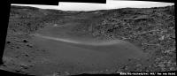
Posted by: PaulH51 Apr 12 2015, 01:00 PM
The end of sol 952 drive direction left mast camera mosaic that features what could be the exit ramp out of the bowl shaped depression (image center)
https://www.flickr.com/photos/105796482@N04/16913329917/sizes/k/
Posted by: PaulH51 Apr 13 2015, 12:00 AM
~200 hundred sols ago when we first arrived at the Pahrump Hills, I created this for an exercise to see if I could better define the possible path through the valley systems towards the mountain. I used a section one of Fred's fine location maps in addition to the extended mission path http://mars.jpl.nasa.gov/msl/images/NASA-MSL-MRO-Curiosity-Rover-HIRISE-Planned-Route-Map-Pahrump-Hills-to-Mount-Sharp-pia18780-full.jpg, but even using that hi-resolution version, the thick yellow line indicating the path masked many of the underlying features. Basically I just avoided the sandy ripples and what appeared to be steep inclines. I used a contour map produced by Joe Knapp for the first few sections of what we now know as Artists Drive, but I cant seem to find Joe's great map.
Now we have the sol 952 end-of-drive mast camera images, we can see what maybe the exit ramp into the next system, looks like I picked the wrong spot on my old plan Going to be an interesting journey...
https://www.flickr.com/photos/105796482@N04/15323669756/sizes/h
Posted here to keep the Maps section for actual maps https://flic.kr/p/pm6P9G
Posted by: neo56 Apr 13 2015, 10:55 AM
My take on MAHLI mosaic of Garden City veins on sol 946 in context with a MC34 mosaic taken on sol 929:
https://flic.kr/p/rPoekE
Posted by: Phil Stooke Apr 13 2015, 01:36 PM
If you compare this sol 954 image:
http://www.midnightplanets.com/web/MSL/image/00954/NRB_482186043EDR_F0460000NCAM00309M_.html
With this 952 image:
http://www.midnightplanets.com/web/MSL/image/00952/NRB_482013202EDR_F0460000NCAM00353M_.html
you can see a little sample dump took place between them.
Phil
Posted by: Arizona Dave Apr 13 2015, 06:33 PM
The lack of images lately is driving me crazy...need more than thumbnails!!! Looks like they found some new interesting rock formations based on thumbnails.
Posted by: algorithm Apr 13 2015, 07:13 PM
Looks like we're having a closer look at the sample dump that Phil noticed.

|
Posted by: neo56 Apr 13 2015, 07:53 PM
The last vein of Garden City imaged by MAHLI, its context with a MC34 mosaic and scale for both images:
https://flic.kr/p/raCb8c
Posted by: Arizona Dave Apr 13 2015, 10:49 PM
Removed full in line quote of previous post - Mod
Awesome Mosaic!
Those veins remind me of exposed surface tree roots that grow on grassy areas, like my backyard.
Very cool!
Posted by: Arizona Dave Apr 13 2015, 11:02 PM
Some really interesting rocks and small dunes from the NavCams on Sol 952.
http://mars.jpl.nasa.gov/msl/multimedia/raw/?rawid=NLB_482006748EDR_D0451768TRAV00319M_&s=952
Some of the larger pics show a wide variety of rock types and shapes...like a debris flow-field I see in deserts out here.
Posted by: Arizona Dave Apr 13 2015, 11:07 PM
That Sand with the sun lighting from directly behind is looks like its glowing...like some types of silica-sand on Earth. It might be the wavelength of light the NavCam is set to see...but Mt Sharp is glowing also...really neat.

|
Posted by: PaulH51 Apr 15 2015, 04:37 AM
Based on Phil's latest update and using a crop from JPL's sol 951 location map, I have plotted a possible path from the current location into the next system.
The latest USGS Curiosity Mission Update shows a planned drive for sol 956 (~6 hours from now) Ryan indicates that the drive is scheduled for ~2 hours, so if all goes well, we may enter the next system. I am sure there are many other possible paths, this is just for fun only.
https://www.flickr.com/photos/105796482@N04/16965818470/sizes/h/
http://astrogeology.usgs.gov/news/astrogeology/sol-956-mercury-transit
Posted by: Floyd Apr 15 2015, 11:22 AM
Thanks Paul. Nice to see the probable route on the detailed color map.
Posted by: PaulH51 Apr 15 2015, 01:15 PM
The first images of the drive on sol 956 are now available. I have used 4 L-NavCam images for this simple and roughly stitched mosaic, others will make far better versions which I look forward to seeing here....
We appear to be just in front of the entrance into the next system and it does looks inviting, ignoring the potential for sand traps
Maybe a short drive forward to better see what awaits us and to plan for the longer drives? Time will tell...
https://www.flickr.com/photos/105796482@N04/16969228620/sizes/h/
Posted by: Phil Stooke Apr 15 2015, 01:46 PM
A quick circular view of this site to show a different perspective. I expect we can go quite a way into the valley ahead on the next drive.
Phil

|
Posted by: Gerald Apr 15 2015, 02:03 PM
Sol 956 NRB post-drive semipan:
http://imgur.com/IVYXjYn
Edit: Sol 956 NRB 3-image mid-drive mosaic:
http://imgur.com/M9YE5JZ
Posted by: Gerald Apr 15 2015, 03:40 PM
A moderately successful anaglyph version of the stitched Sol 956 Navcam mid-drive images:
http://imgur.com/KuXtlX9
Posted by: Ant103 Apr 15 2015, 05:04 PM
My take on these two panoramic. What we can say about the view is "WOW !"
http://www.db-prods.net/marsroversimages/Curiosity/2015/Sol956_pano1.jpg
http://www.db-prods.net/marsroversimages/Curiosity/2015/Sol956_pano2.jpg
Posted by: Arizona Dave Apr 15 2015, 06:08 PM
Nice Mosaics!
Looks like a lot of dust in air out a ways to the crater rim.
Also...new pics of rocks and soil today very interesting: http://mars.jpl.nasa.gov/msl/multimedia/raw/?rawid=0955MH0004960030304217C00_DXXX&s=955
Notice the "crack" in the soil...freeze/thaw of brine possibly? Its obviously fairly recent. Also, lots of rounded rocks...more evidence for fast flowing water in past.
Posted by: fredk Apr 15 2015, 06:54 PM
Fairly recent is right - that's due to work with the turret. Notice that several pebbles have been pushed into the soil, leading to cracks.
The "before" view (lower right corner):
http://mars.jpl.nasa.gov/msl-raw-images/msss/00952/mcam/0952ML0041950010403452E01_DXXX.jpg
shows that these features weren't there a few sols earlier.
Posted by: vikingmars Apr 15 2015, 07:05 PM
My interpretation of Sol 956 view in 3-D... Enjoy !

|
Posted by: djellison Apr 15 2015, 07:54 PM
Or simply imaging the area that the APXS was pressed into just a few minutes before
http://mars.jpl.nasa.gov/msl/multimedia/raw/?rawid=FRB_482286249EDR_F0460000FHAZ00206M_&s=955
Posted by: Phil Stooke Apr 15 2015, 08:54 PM
This is a circular version of Damia's sol 952 panorama, giving a nice view of the outcrops around this broad shallow depression. Mount St Mary appears to be the hilly area southeast of this rover location.
Phil
|
Posted by: PaulH51 Apr 15 2015, 11:12 PM
Sol 955 : 3-frame MC100 mosaic featuring the location where the rover stopped at the end of its sol 956 drive.
https://www.flickr.com/photos/105796482@N04/16541456953/sizes/k/
Posted by: Arizona Dave Apr 15 2015, 11:54 PM
http://mars.jpl.nasa.gov/msl/multimedia/raw/?rawid=FRB_482286249EDR_F0460000FHAZ00206M_&s=955
Yep, see it now, pebbled very clearly pushed down and to side. Dang, was hoping for one of those moments like when Opportunity uncovered what appeared to be ice/front under its tracks one time.
Has anyone else noticed more appearance of veins in some of the daily Navcam shots? Not close enough to say for sure, but appears possible some along side several of the valley walls scattered.
Posted by: djellison Apr 16 2015, 12:25 AM
Are you referring to when Spirit uncovered amorphous silica deposits near Home Plate?
http://photojournal.jpl.nasa.gov/catalog/PIA11758
Posted by: atomoid Apr 16 2015, 01:11 AM
..or perhaps the http://www.nasa.gov/mission_pages/phoenix/images/press/20080531.html uncovered beneath Phoenix, or in http://upload.wikimedia.org/wikipedia/commons/3/3e/Evaporating_ice_on_Mars_Phoenix_lander_image.jpg. as well as cryoturbation http://upload.wikimedia.org/wikipedia/commons/5/5c/Phoenix_mission_horizon_stitched_high_definition.jpg.
brings up the question that if there was indeed an epoch of permafrost, snowpack, or even glaciation during some Milankovitch cycle at these latitudes, could there still be any evidence visible or should have long since deflated away?
Posted by: PaulH51 Apr 16 2015, 01:32 AM
Would it be possible to create an anaglyph using the two sets of NavCam images (wide base-line)?
Posted by: PaulH51 Apr 16 2015, 09:10 AM
Updated MSL map, rotated 90 degrees to align with the NavCam view into the next section, hopefully this will makes it a little easier to identify some of the prominent features.
https://www.flickr.com/photos/105796482@N04/17164680151/sizes/h/
Latest USGS Mission Update from Ken Herkenhoff http://astrogeology.usgs.gov/news/astrogeology/sol-957-limited-downlink
Posted by: Ant103 Apr 16 2015, 11:28 AM
Sol 956 Navcam pan updated (see my previous post, instead of publish twice the same picture).
Posted by: Phil Stooke Apr 16 2015, 04:07 PM
New images... we had a drive on sol 957. I'm not sure of the exact location yet but it looks like about 15 m roughly west, with the Navcam mini-pan looking northwest.
(Midnight planets reporting 60+ m west. I can't make that work. EDIT - ah - OK, now I'm making it work! OK, got it)
Phil

|
Posted by: Gerald Apr 16 2015, 04:25 PM
A try to stitch some of the Sol 957 NRBs:
http://imgur.com/iRtZG31
Posted by: jvandriel Apr 16 2015, 07:49 PM
The Navcam NL B Panoramic view on Sol 957.
Jan van Driel
|
|
Posted by: vikingmars Apr 16 2015, 08:55 PM
Sol 957 of Curiosity's mission : another gorgeous view in 3-D ! Enjoy

|
Posted by: PaulH51 Apr 16 2015, 11:35 PM
Nice MAHLI from sol 952
https://www.flickr.com/photos/105796482@N04/16985646359/sizes/l/
JPL issued this http://mars.jpl.nasa.gov/msl/multimedia/images/?ImageID=7118 which gives us a new name for PHil's maps
Posted by: charborob Apr 17 2015, 02:14 AM
Nice http://www.midnightplanets.com/web/MSL/latestImages.html (thumbnails?) have come down.
Posted by: PaulH51 Apr 17 2015, 02:25 AM
Those should be the http://astrogeology.usgs.gov/news/astrogeology/sol-956-mercury-transit I'll be watching for the full frames
Posted by: Gerald Apr 17 2015, 09:52 PM
Sol 958 preliminary NRB pano:
http://imgur.com/7zMqJNy
Posted by: PaulH51 Apr 17 2015, 11:14 PM
Left mast camera, looking West after the drive on sol 957
https://www.flickr.com/photos/105796482@N04/16994197328/sizes/h/
USGS Mission Update from Ryan Anderson http://astrogeology.usgs.gov/news/astrogeology/sol-958-officially-10k-
Posted by: Gerald Apr 18 2015, 12:36 AM
In some cases. Here an attempt with a cropped (and slightly rotated) Sol 957/958 NRB pair:
|
|
Posted by: PaulH51 Apr 18 2015, 01:52 AM
Many thanks Gerald
I really appreciate your contributions across this forum.
Posted by: jvandriel Apr 18 2015, 07:16 AM
The Navcam NL B Panoramic view on Sol 958.
Jan van Driel

|
Posted by: neo56 Apr 18 2015, 01:41 PM
MC100 picture and two successive MAHLI zoom on Telegraph Peak drill sample. Pictures taken on sol 954.
https://flic.kr/p/sbNDXZ
Posted by: Phil Stooke Apr 18 2015, 07:31 PM
Jan's latest pan in circular format.
Phil

|
Posted by: charborob Apr 18 2015, 08:35 PM
Sol 957 pre-drive right mastcam panorama:

|
Posted by: PaulH51 Apr 18 2015, 10:21 PM
Sol 958 : drive-direction left mast camera.
https://www.flickr.com/photos/105796482@N04/17004579190/sizes/h/
Posted by: neo56 Apr 19 2015, 10:38 AM
My take on the MC100 panorama taken on sol 957:
https://flic.kr/p/rV6KnG
and MC34 mosaic of Libby outcrop:
https://flic.kr/p/rVg7ck
Posted by: Ant103 Apr 19 2015, 12:48 PM
Sol 958 Navcam pan :
http://www.db-prods.net/marsroversimages/Curiosity/2015/Sol958_pano.jpg
Posted by: algorithm Apr 19 2015, 07:59 PM
From Sol960,
A NavCam anaglyph

|
Posted by: algorithm Apr 19 2015, 08:01 PM
And a HazCam one. (Slightly tortured)

|
Posted by: PaulH51 Apr 20 2015, 06:38 AM
18 frames (complete?) version of the pre-drive right mast camera panorama looking WSW (some colour correction applied)
https://www.flickr.com/photos/105796482@N04/17207979421/sizes/h/
Posted by: atomoid Apr 20 2015, 09:36 PM
washed-out Mt. Sharp mini-pano sol960
|
|
Posted by: PaulH51 Apr 21 2015, 06:41 AM
Sol 960 Drive direction left mast camera mosaic. Maybe considering going north of the butte and then dropping south into the pass to avoid driving through the sand on the south side of the butte? See Phil's latest map
https://www.flickr.com/photos/105796482@N04/17218695942/sizes/h/
Posted by: vikingmars Apr 21 2015, 08:07 AM
In this very interesting image, taken Sol 958, you can see two different sediments : a light-colored one (the most usual on which we roved for many Sols) and a dark-colored one, which seems to be fine-powdered (center) : maybe a preview of the dark-colored dunes to be seen later on the mission... Enjoy !

|
Posted by: jvandriel Apr 21 2015, 02:05 PM
The Navcam L Panoramic view on Sol 960.
Jan van Driel
Edit. (Added 1 image)
|
|
|
|
Posted by: Dig Apr 21 2015, 04:53 PM
Left Navcam Sol 960 Full Resolution.
http://bit.ly/1bpX4a9
Click image for full resolution.
http://bit.ly/1jvdOKg
Posted by: Arizona Dave Apr 21 2015, 05:10 PM
Ive been noticing a lot of the wide-variations in sand as well...some of the sand appears extremely bright. I wonder if part of this is due to longer-wavelength infrared being allowed to be filtered through?
Posted by: atomoid Apr 21 2015, 09:46 PM
it looks like http://www.midnightplanets.com/web/MSL/image/00958/NLB_482545774EDR_F0461162NCAM00299M_.html was relatively overexposed in the Left pancam, is more equalized in the Right frame, nonetheless its bright enough to consider possibly sourced from erosion of (thanks Gerald) MgO=5.8% CaO=56.3% veins. dark sand ive always assumed basaltic but never read up on it.. (the stereo of this wasn't very satisfying so here just posting the R pano).

|
Posted by: PaulH51 Apr 22 2015, 04:10 AM
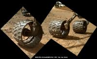
Another 4 sets of wheel check MAHLI images during sol 962
Animations of just one wheel (reduced to 1024 x 777) : http://i.imgur.com/Lhmks8F.gifv or https://www.flickr.com/photos/105796482@N04/17229539221/sizes/o/ All Images http://www.midnightplanets.com/web/MSL/sol/00962.html
Posted by: PaulH51 Apr 22 2015, 08:20 AM
USGS Curiosity Mission Update from Lauren Edgar http://astrogeology.usgs.gov/news/astrogeology/sol-963-making-a-run-for-it checking out "Logan's Run"
Posted by: Phil Stooke Apr 22 2015, 04:44 PM
This is a circular view of Dig's sol 960 panorama. I was pretty far off with my last map, as I mistook one or two nearby features for others. I will fix the map after the next drive.
Phil

|
Posted by: PaulH51 Apr 22 2015, 09:33 PM
Mars Orbiter Sees Curiosity Rover in 'Artist's Drive' during sol 949 http://photojournal.jpl.nasa.gov/catalog/PIA19392 - http://photojournal.jpl.nasa.gov/jpeg/PIA19392.jpg - http://photojournal.jpl.nasa.gov/figures/PIA19392_fig1.jpg
Posted by: PaulH51 Apr 23 2015, 12:02 AM
Simple merge/stack focus and red/cyan anaglyph using just 9 frames of the ChemCam-RMI target dubbed "Apple" acquired during Sol 963
https://www.flickr.com/photos/105796482@N04/17213017356/sizes/l/
Click image or this https://www.flickr.com/photos/105796482@N04/17213017356/sizes/l/
Posted by: Arizona Dave Apr 23 2015, 12:49 AM
Do you know where the "Apple" is in relation to this pan? (Nice pano btw!, overexposed or not, it shows a LOT of different composition materials)
ADMIN: About 100 metres away in the opposite direction. Refer to the http://www.unmannedspaceflight.com/index.php?showtopic=7442&view=findpost&p=219737.
Posted by: PaulH51 Apr 23 2015, 03:52 AM
USGS http://astrogeology.usgs.gov/news/astrogeology/sols-964-965-logan-s-run-or-just-a-short-dash- : Sols 964-965: Logans Run? Or just a short dash, from Lauren Edgar
Joe's http://curiosityrover.com/tracking/drivelog.html has already been updated, but the map appears to contain a small offset to the south.
Very roughly stitched sol 963 post-drive left NavCam pano. The other available frames were giving huge stitching errors, so I omitted them.
https://www.flickr.com/photos/105796482@N04/16622093443/sizes/l/
Link to Flickr preview https://flic.kr/p/rjQzgZ
Posted by: jvandriel Apr 23 2015, 11:41 AM
The complete Navcam NL B Panoramic view taken on Sol 963.
Jan van Driel
|
|
Posted by: Phil Stooke Apr 23 2015, 05:33 PM
Very nice, Jan - here's a circular version of it.
Phil

|
Posted by: Zelenyikot Apr 23 2015, 07:50 PM
MAHLI at Sols 960, 963.

|

|
Posted by: algorithm Apr 23 2015, 08:57 PM
Sol963 MC100 pan with added saturation.

|
Posted by: charborob Apr 24 2015, 12:16 AM
Wow! A new driving distance record 
|
Posted by: PaulH51 Apr 24 2015, 08:11 AM
One of the post-drive L-MastCam mosaics from sol 963, this one looking south toward the entrance to Logan Pass (contrast stretched)
https://www.flickr.com/photos/105796482@N04/17045164357/sizes/h/
Posted by: PaulH51 Apr 24 2015, 12:35 PM
Lengthening Shadows - One hour before sunset on sol 964. Contrast stretched.
https://www.flickr.com/photos/105796482@N04/16630800014/sizes/o/
Posted by: Dig Apr 24 2015, 02:13 PM
Left Navcam Sol 964 Full Resolution.
http://bit.ly/1OOrqj2
Click image for full resolution.
http://bit.ly/1jvdOKg
Posted by: Phil Stooke Apr 24 2015, 02:31 PM
A very nice view! This is a circular version of it. You can see the big crater to the northwest - in HiRISE it shows up with dark drifts on its floor. Here we just see the northern and southern ridges which define it.
Phil

|
Posted by: neo56 Apr 24 2015, 07:12 PM
My take on MC34 panorama of sol 963. According to Phil's map, West Ridge is on the right and Logan Pass is between West Ridge and the background ridge.
https://flic.kr/p/shSbYF
Posted by: Gerald Apr 24 2015, 10:02 PM
Sol 964 MastCam Right thumbnails, Target "Blackrock", which stopped the Sol 963 drive:

|
Posted by: Gerald Apr 25 2015, 01:36 AM
Quick-and-dirty version of the Sol 964 post-drive Left Mastcam 5-image mosaic:
http://imgur.com/ib6aoH4
Posted by: Phil Stooke Apr 25 2015, 01:24 PM
"According to Phil's map"
Yes... but unfortunately I don't know where that ridge actually is. I am waiting for a map with some names, or or other confrmation, to locate that and several other names.
Phil
Posted by: jvandriel Apr 25 2015, 02:16 PM
The last Mastcam L images of Sol 938 are down, debayered and stitched.
Jan van Driel
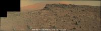
|
Posted by: neo56 Apr 25 2015, 05:09 PM
My take on MC34 and MC100 mosaic of Logan's Run on sol 964. High difference of luminosity between individual pictures made difficult to obtain homogeneous mosaics.
https://flic.kr/p/siAvb9
https://flic.kr/p/siNcki
https://www.flickr.com/photos/105035663@N07/17266669675/sizes/o/
Posted by: jvandriel Apr 25 2015, 08:14 PM
All the MASTcam L images of Sol 964 stitched together.
Jan van Driel

|
Posted by: jmknapp Apr 26 2015, 02:10 AM
I adjusted the current http://curiositymsl.com/rovermap1.html to match Phil's latest--moved about 12 meters to the northeast.
Posted by: jvandriel Apr 26 2015, 02:10 PM
Enjoy.
Jan van Driel

|
Posted by: neo56 Apr 26 2015, 05:02 PM
My take on the lovely view of sol 952:
https://flic.kr/p/s1w3eD
Posted by: Phil Stooke Apr 26 2015, 05:51 PM
Stunning!
Phil
Posted by: vikingmars Apr 26 2015, 06:24 PM
Thanks Neo56... You win ! I was to post it too !

|
Posted by: Gerald Apr 26 2015, 10:41 PM
Sol 967 Right NavCam half-pan:
http://imgur.com/9Cz8BKq
Posted by: antipode Apr 26 2015, 11:54 PM
Wow. What an amazingly photogenic area. And Oppy is in one too. A real feast for the Mars-scape aesthetes out there ATM.
P
Posted by: marsophile Apr 27 2015, 02:23 AM
The sand (or dust) "sea" looks a bit "choppy" there.
Posted by: charborob Apr 27 2015, 12:08 PM
The view on sol 952 with the right mastcam:
|
|
Posted by: charborob Apr 27 2015, 12:20 PM
Sol 966 left mascam view:

|
Posted by: Gerald Apr 27 2015, 02:14 PM
Sol 967 NRB update:
http://imgur.com/hiP1zm1
Posted by: Phil Stooke Apr 27 2015, 08:11 PM
Thanks, Gerald - here is a circular reprojection of it. Presumably these outcrops in front of us are Logan's Run... I confess I can't quite see what is so special about the area, but what do I know?
Phil

|
Posted by: Gerald Apr 27 2015, 09:09 PM
From http://mars.jpl.nasa.gov/msl/news/whatsnew/index.cfm?FuseAction=ShowNews&NewsID=1803:
The unit characterized by a sequence of almost parallel small valleys and hills seems to be called 'Washboard unit'.
Between the lines I'm reading, that besides Logan Pass, also Logan's Run may be considered a candidate either as a contact/transition zone to the Washbord unit, or as an outcrop revealing the structure and composition of the Washboard unit. Investigating two similar sites improves the confidence in possible results (regarding the Washbord unit and its distinction).
Posted by: Phil Stooke Apr 27 2015, 09:44 PM
I get that... but why divert to Logan's Run rather than go straight to Logan Pass? It looks like it exposes less rather than more.
Phil
Posted by: elakdawalla Apr 27 2015, 11:41 PM
Just a wild guess: maybe they judged an outcrop to be more likely to be reachable by in-situ instruments?
Posted by: atomoid Apr 28 2015, 12:09 AM
Heres a crosseye for a section of those great http://www.midnightplanets.com/web/MSL/image/00952/0952ML0041900030403409E01_DXXX.html pancam views. and a fun section of the recent http://www.midnightplanets.com/web/MSL/image/00828/0828ML0036350660401240E01_DXXX.html downlinks as well
|
|

|
(if too wide, open in SPM http://stereo.jpn.org/eng/stphmkr from IE context menu for easy pan/zoom)
Posted by: serpens Apr 28 2015, 07:01 AM
.
Actually the view is Mt. Shields - the wheels are on Logan's Run. Not sure about accessibility but these are nicely differentiated outcrop layers.
Posted by: Phil Stooke Apr 28 2015, 10:08 AM
Yes... the new USGS blog gives us the details. I'm hoping for one of Fred Calef's nice maps annotated with placenames to give me some more certainty about other names.
Phil
Posted by: PaulH51 Apr 28 2015, 10:25 AM
You may not have to wait too long, Fred has been tweeting this seek as astrotweeps... Here is a little preview he gave https://twitter.com/astrotweeps/status/592755331815624705
Posted by: Gerald Apr 28 2015, 11:21 AM
If asked where to take samples along the direction marked by the dark red line in this annotated crop

|
of the file http://mars.jpl.nasa.gov/msl/images/mars-rover-curiosity-msl-traverse-map-10k-drive-Sol957-PIA18390-br2.jpg (full-res http://mars.jpl.nasa.gov/msl/images/mars-rover-curiosity-msl-traverse-map-10k-drive-Sol957-PIA18390-full.jpg) - given limited ressources - to test linear models of the Washboard unit, I'd prefere points far apart in terms of projections onto the coordinate axis of interest, since interpolation is most sensitive to the lower and upper bound of the considered interval:

|
So under the aspect to find out a trend roughly along the marked dark red line in the annotated crop above, the decision to look at Logan's Run/Mt. Shields makes sense, without knowing whether this consideration has actually been part of the decision process.
Posted by: Phil Stooke Apr 28 2015, 02:11 PM
"You may not have to wait too long, Fred has been tweeting....."
Excellent, thanks! Just using that I have been able to fix and add to my map, so there is an updated route map today.
Phil
Posted by: algorithm Apr 29 2015, 02:11 PM
Sol 967 NavCam images cropped as an anaglyph.

|
Posted by: algorithm Apr 29 2015, 03:23 PM
Another Sol967 NavCam anaglyph, showing how stoney it is around here. Hopefully lots of soft sandy soil to push them into.

|
Posted by: algorithm Apr 29 2015, 05:54 PM
Sol969 FHaz anaglyph.
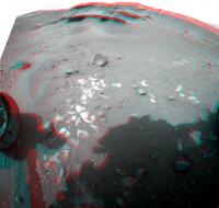
|
Posted by: algorithm Apr 29 2015, 06:22 PM
With reference to post #626, I noticed that the right 55% or so of the image is predominantly sand and the left mostly stoney.
I kind of assumed that it was to do with the prominance of the rocky outcrops catching wind blown grains, and therefore defining some sort of boundary, would this be correct?
Posted by: atomoid Apr 29 2015, 09:09 PM
..you probably mean http://www.unmannedspaceflight.com/index.php?showtopic=7988&view=findpost&p=219864? if so id assume the opposite cause, sand dunes likely indicating the prevailing wind patterns with the leeward side of the ridge where the sand collects atop the otherwise similar stony terrain sourced from the windy side where it is blown relatively quickly off of over to the leeward side. in any case the question remains how long has it taken for this to accumulate?
Posted by: PaulH51 Apr 30 2015, 12:26 PM
sol 969, 6x3 R-MastCam mosaic of a section of the "Mt. Shields" outcrop.
https://www.flickr.com/photos/105796482@N04/17319160472/sizes/h/
This mosaic is mentioned in the latest USGS Mission Update "Sol 969-970: Studying Mt. Shields" http://astrogeology.usgs.gov/news/astrogeology/sol-969-970-studying-mt-shields
Posted by: Gerald Apr 30 2015, 01:03 PM
A http://en.wikipedia.org/wiki/River_delta#Sedimentary_structure of a http://en.wikipedia.org/wiki/River_delta#Gilbert_deltas?
Posted by: dburt Apr 30 2015, 06:18 PM
Possible, but there are several depositional environments that can have inclined bedding. This is just an isolated small outcrop. I'd probably want to see more of the package (e.g., a complete sandwich including horizontal topset beds on top and bottomset beds underneath) before arriving at such a hypothesis.
dburt
Posted by: fredk Apr 30 2015, 11:45 PM
Pebble going for a ride:
http://mars.jpl.nasa.gov/msl-raw-images/msss/00971/mhli/0971MH0002620000304268E01_DXXX.jpg
Posted by: PaulH51 May 1 2015, 08:15 AM
Partial left navcam pano of the arrival at the Mt Shields outcrop.
https://www.flickr.com/photos/105796482@N04/17329445545/sizes/l/
Posted by: jvandriel May 1 2015, 08:48 AM
Partial Navcam L view on Sol 971.
Jan van Driel

|
Posted by: MahFL May 1 2015, 11:30 AM
Reminds me of Spirit in Eagle Crater .
Posted by: jvandriel May 1 2015, 01:26 PM
and here is the complete view on Sol 971.
Jan van Driel

|
Posted by: fredk May 1 2015, 01:52 PM
I don't think Spirit made it quite that far around the planet...

Posted by: PDP8E May 1 2015, 09:07 PM
Fred,
it took me a couple of seconds, but that was pretty funny....
Posted by: Habukaz May 1 2015, 10:20 PM
The way things are turning out, I think it would be more likely to see Opportunity in Gusev Crater.... where it could nudge Spirit back into life, and then they can travel to Eagle Crater together.
Posted by: Gladstoner May 1 2015, 11:41 PM
Who's on Home Plate?
Posted by: PaulH51 May 1 2015, 11:53 PM
Delicate layering at Mt Shields - sol 971 L-MastCam
https://www.flickr.com/photos/105796482@N04/16716738643/sizes/l/
Posted by: PaulH51 May 2 2015, 04:51 AM
USGS Curiosity Mission Update from Ken Herkenhoff :http://astrogeology.usgs.gov/news/astrogeology/sol-973-975-albert-bigfork-and-charity
Posted by: PaulH51 May 2 2015, 05:27 AM
Drive direction? mast camera mosaic looking SSE, sol 971. Maybe for when they finish up at Mt Shields?
https://www.flickr.com/photos/105796482@N04/17131740547/sizes/h/
Posted by: Phil Stooke May 2 2015, 07:59 AM
A circular view of the current location on sol 971, from Jan's panorama.
Phil

|
Posted by: PaulH51 May 2 2015, 09:07 AM
Locations identified for 2 of the recent ChemCam-RMI targets at Mt Shields (R-MastCam 969, RMI's 970 & 971)
https://www.flickr.com/photos/105796482@N04/17339999801/sizes/l/
Posted by: eliBonora May 2 2015, 09:38 AM
Here 2 last our anaphyphs
sol 964
https://flic.kr/p/sjToow
and sol 969
https://flic.kr/p/spDium
Posted by: blake May 2 2015, 02:59 PM
Those layers "look" extremely delicate.
Amateur Question: Would the arm or turret ever be used to try and break some of these rock layers (maybe by preloading the drill against it, for example)? Would there be any science gained from such an action (maybe to see the inside of a rock or measure shear strength)?
Just wondering, thanks.
Posted by: Phil Stooke May 2 2015, 03:04 PM
Absolutely not the arm! It's full of delicate equipment. But the wheels sometimes break rocks as they drive over them (Curiosity in Yellowknife Bay at Snake, for instance, or Opportunity at Pinnacle Island) and sometimes it's even done deliberately to create a fresh surface for analysis.
Phil
Posted by: PaulH51 May 3 2015, 03:20 AM
ChemCam-RMI target from sol 973. I'm not sure if it is http://astrogeology.usgs.gov/news/astrogeology/sol-973-975-albert-bigfork-and-charity
https://www.flickr.com/photos/105796482@N04/16729155623/sizes/l/
Posted by: Phil Stooke May 3 2015, 08:07 AM
It must be Charity, because according to the USGS blog Albert will be the site of DRT brushing later... and they would never brush that flimsy thing.
Phil
Posted by: PaulH51 May 3 2015, 08:46 AM
Nicely deduced Phil... "Once you eliminate the impossible, whatever remains, no matter how improbable, must be the truth."
Posted by: PaulH51 May 3 2015, 11:59 AM
Sol 953 R-MastCam, raw and stretched versions.
https://www.flickr.com/photos/105796482@N04/17352697931/sizes/h/
Full size https://www.flickr.com/photos/105796482@N04/17352697931/sizes/o/
Posted by: Gerald May 3 2015, 03:30 PM
Some of the crêpe-like laminae have also been beneath the rover on Sol 972, here a http://mars.jpl.nasa.gov/msl-raw-images/msss/00972/mrdi/0972MD0003830000103699E01_DXXX.jpg image processed by "dust-decoating", color modification (applying color-correction for Mastcam images), and linearization (squaring raw color values) :
http://imgur.com/xLnVI95
Posted by: neo56 May 3 2015, 04:59 PM
Some MC34 and MC100 mosaics of Artist's Drive valley which were downloaded lately:
North side of Artist's Drive valley with MC100 and MC34 on sol 950:
https://flic.kr/p/s89YpL https://flic.kr/p/spLNAM
Southeast side of Artist's Drive valley with MC34 on sol 950:
https://flic.kr/p/rtTZP6
Northwest side of Artist's Drive valley with MC34 on sol 951:
https://flic.kr/p/sornNW
Tucki Mountain on southeast side of Artist's Valley with MC34 on sol 951:
https://flic.kr/p/sqQ6u4
Posted by: centsworth_II May 3 2015, 06:20 PM
It looks like a few shots of the ChemCam laser could bore a hole clear through one of those plates.
Posted by: PaulH51 May 3 2015, 11:56 PM
Telescopic RMI imaging the distant target named 'Empire'
https://www.flickr.com/photos/105796482@N04/17174273879/sizes/o/
https://www.flickr.com/photos/105796482@N04/17174273879/sizes/o/
Posted by: PaulH51 May 4 2015, 02:33 AM
Roughly stitched overlapping MAHLI's from sol 974 (Mt Shields)
https://www.flickr.com/photos/105796482@N04/17154611327/sizes/o/
https://www.flickr.com/photos/105796482@N04/17154611327/sizes/o/
Posted by: Phil Stooke May 4 2015, 02:14 PM
This is the location of Empire on a Navcam frame - it is south east of the rover.
Phil

|
Posted by: algorithm May 4 2015, 07:41 PM
An anaglyph from two focus merged MAHLI images from Sol974

|
Posted by: neo56 May 4 2015, 07:53 PM
Panorama of the base of Mt Sharp and Grey Wolf Peak taken with MC100 on sol 952:
https://flic.kr/p/srHe2T
A close-up on the hills and canyons of Mt Sharp. I'm looking forward to see Curiosity driving in this region!
https://flic.kr/p/sqKq8C
Posted by: Arizona Dave May 4 2015, 09:30 PM
Hopefully the wheels can make it
Posted by: Arizona Dave May 4 2015, 09:59 PM
[/url]
A close-up on the hills and canyons of Mt Sharp. I'm looking forward to see Curiosity driving in this region!
That valley up the middle in the distance looks so similar to the Devils Corkscrew coming up out of the Grand Canyon! Awesome.
Question on Colors: Ive noticed several of the images were the sky has blue-ish tones, but recently the sky is very orange, is it just different angles/time of day, or is the color processing different? It doesnt seem like a dust storm because you can see so far and details on the hills that are 10-20 miles away, maybe upper atmosphere dust?
Posted by: Gladstoner May 4 2015, 10:53 PM
I'm reminded of the area around Moab, Utah. I can imagine the Slickrock Trail on the light-toned stuff.
Posted by: Floyd May 5 2015, 12:12 AM
Dave
Martian sky color has be much discussed here in dozens if not hundreds of threads and you can find out a lot by searching and reading. Orange is usual--close to what we would see if there--blue shows up in color stretched images and some sunsets. Skies are only blue on Mars if you are in a spacecraft above a high percentage of the atmosphere...
Posted by: stevesliva May 5 2015, 12:27 AM
I believe that's Navajo sandstone, and it erodes into domes in a number of places, like the San Rafael Swell and Capitol Reef. https://scontent.xx.fbcdn.net/hphotos-xpf1/t31.0-8/257961_695576062836_4141172_o.jpg Always think of that when I see Mt. Sharp.
Posted by: Gladstoner May 5 2015, 12:59 AM
The Navajo ss. is amazing, magical stuff.
Posted by: PaulH51 May 5 2015, 01:53 AM
USGS Curiosity Mission Update from Ken Herkenhoff http://astrogeology.usgs.gov/news/astrogeology/sols-976-977-onward-to-jocko-butte
Posted by: Gerald May 5 2015, 04:59 PM
As fragile as the laminae look from a distance, they seem to be much more abrasion resistant than the soft rock at Pahrump: http://mars.jpl.nasa.gov/msl-raw-images/msss/00975/mhli/0975MH0004760010304378C00_DXXX.jpg.
Powered by Invision Power Board (http://www.invisionboard.com)
© Invision Power Services (http://www.invisionpower.com)