The "Lump of Good Hope", Significant..? |

  |
The "Lump of Good Hope", Significant..? |
 Feb 22 2007, 08:49 PM Feb 22 2007, 08:49 PM
Post
#1
|
|||
 Senior Member  Group: Members Posts: 4246 Joined: 17-January 05 Member No.: 152 |
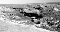
Interesting blocky feature visible in the latest navcams (centred in this crop):
I've identified it orbitally - it's the block marked with the black arrow in this crop:
It appears to be at the exposed end of - dare I say it - a linear feature marked with white arrows in that crop. |
||
 |
 
|
||
|
Feb 22 2007, 09:20 PM
Post
#2
|
|
|
Member Group: Members Posts: 242 Joined: 17-February 04 From: Ohio, USA Member No.: 34 |
Good observation noting the apparent linear feature. I'll withhold comment for now
 ... ... That big block looks like it's in the brecciated zone. I wonder if it's just a mega-sized fragment in the breccia. |
|
|
|
|
Feb 22 2007, 09:26 PM
Post
#3
|
|
 Senior Member Group: Members Posts: 3419 Joined: 9-February 04 From: Minneapolis, MN, USA Member No.: 15 |
It's a little tough to say whether the feature in question is linear or arcuate, though I admit it looks more linear to me. (If it's arcuate, it's not really concentric to the impact point, is it...?)
-the other Doug -------------------- The trouble ain't that there is too many fools, but that the lightning ain't distributed right. -Mark Twain
|
|
|
|
|
Feb 22 2007, 09:35 PM
Post
#4
|
|
|
Senior Member Group: Members Posts: 3419 Joined: 9-February 04 From: Minneapolis, MN, USA Member No.: 15 |
Looking at the features along this portion of the rim a little more carefully, I get a gestalt impression of the entire landmass that contains the current capes and bays having slumped down fractures as the pressure of the mass in the rockbed has decreased as the rockbed has descended into the crater pit.
Look at it this way -- the Guam area, and the area along this new linear feature, are all places where the land between the feature and the rim of Victoria has slumped down a bit, a few centimeters here and there. No more than half a meter, I'd bet, anywhere along the line. Now, these may have been impact-created fractures or they may have been pre-existing, but as mass was removed from the rockbeds between these fractures and the rim of the crater, the entire rockbled has slumped along these fracture lines. Leaving these little ridges that we're seeing, here. Looking at it, my first impression is that the Guam formation represents slumping along an impact-generated fracture, while this linear feature is along a pre-existing linear fracture within the rockbeds. -the other Doug -------------------- The trouble ain't that there is too many fools, but that the lightning ain't distributed right. -Mark Twain
|
|
|
|
|
Feb 23 2007, 11:01 AM
Post
#5
|
|
|
Senior Member Group: Moderator Posts: 4279 Joined: 19-April 05 From: .br at .es Member No.: 253 |
While waiting for today's batch of images from Opportunity, just tell that the next cape clockwise (C3) has been named Cape of Good Hope.
|
|
|
|
|
Feb 23 2007, 12:04 PM
Post
#6
|
||
|
Senior Member Group: Moderator Posts: 4279 Joined: 19-April 05 From: .br at .es Member No.: 253 |
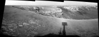
Sol 1096 images are downlinked and available.
Here is a three-frame navcam mosaic looking east and covering Bay C3, Cape of Good Hope (C3), Bay C5, and Cape D1.
Edit: I'm wondering if we would have a chance to "snif" the bright layer of bedrock --the first layer right below the jumbled ejecta-- we have seen on all (?) bays and capes since Duck Bay. It looks like that layer might be accessible at the tip of cape D1 or perhaps the one following D1. 
|
|
|
|
|
|
|
Feb 23 2007, 02:17 PM
Post
#7
|
||
 The Poet Dude Group: Moderator Posts: 5551 Joined: 15-March 04 From: Kendal, Cumbria, UK Member No.: 60 |
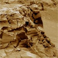
Quick close-up...
-------------------- |
|
|
|
|
|
|
Feb 23 2007, 02:53 PM
Post
#8
|
||
|
Junior Member Group: Members Posts: 52 Joined: 24-May 06 Member No.: 784 |
QUOTE (Tesheiner @ Feb 23 2007, 12:04 PM)  Here is a three-frame navcam mosaic looking east and covering Bay C3, Cape of Good Hope (C3), Bay C5, and Cape D1. Cape of Good Hope(C3) and Cape D1 look like they were uplifted during the impact -- more so than some of the other capes we've seen to date. Very interesting stuff.
(Feel free to move this to a new cape thread) |
|
|
|
|
|
|
Feb 23 2007, 04:02 PM
Post
#9
|
|
|
Senior Member Group: Members Posts: 3516 Joined: 4-November 05 From: North Wales Member No.: 542 |
QUOTE (dvandorn @ Feb 22 2007, 09:35 PM) Looking at the features along this portion of the rim a little more carefully, I get a gestalt impression of the entire landmass that contains the current capes and bays having slumped down fractures as the pressure of the mass in the rockbed has decreased as the rockbed has descended into the crater pit. -the other Doug This sounds very like what I have been suggesting for some time. Just add one ingredient - a buried layer of highly hydrated material that got fluidised by the impact shock. |
|
|
|
|
Feb 23 2007, 04:26 PM
Post
#10
|
|
|
Senior Member Group: Members Posts: 4246 Joined: 17-January 05 Member No.: 152 |
QUOTE (Tesheiner @ Feb 23 2007, 11:01 AM) ... the next cape clockwise (C3) has been named Cape of Good Hope. I'm curious where you heard this Tesheiner?
|
|
|
|
| Guest_Edward Schmitz_* |
Feb 23 2007, 04:34 PM
Post
#11
|
|
Guests |
Is anyone else curious about that lump on the next cape. It looks like an intact out crop where I would expect jumbled ejecta.
ed |
|
|
|
|
Feb 23 2007, 04:58 PM
Post
#12
|
|
|
Member Group: Members Posts: 240 Joined: 18-July 06 Member No.: 981 |
Its a very interesting lump indeed. Perhaps a single large block of ejecta that has resisted erosion, or come from another impact?
The dark material at the base of the eastern capes is getting more interesting as we get closer. It seems to be associated with a specific layer in the section which is perhaps more fully exposed along the northeastern extent of the crater edge. Maybe it is a blueberry rich seam? |
|
|
|
|
Feb 23 2007, 05:12 PM
Post
#13
|
|
|
Senior Member Group: Moderator Posts: 4279 Joined: 19-April 05 From: .br at .es Member No.: 253 |
QUOTE (fredk @ Feb 23 2007, 05:26 PM) I'm curious where you heard this Tesheiner? Elementary, my dear Watson!  Among the planned imaging sequences for tosol (1096) was this one: 01096 p2373.10 16 0 0 16 2 34 pancam_cape_good_hope_longbaseline_L257R2 |
|
|
|
|
Feb 23 2007, 05:46 PM
Post
#14
|
||
|
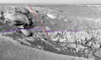
Member Group: Members Posts: 240 Joined: 18-July 06 Member No.: 981 |
You can see the Lump of Good Hope in the attached image cropped and up-sized from the original MRO shot. It does seem quite out of place and is possibly associated with an east northeast-trending fault. I hesitate to call it that because all I see is the barest indication that there may be a fault which has created some elevation differential leading to the abrupt edge of the dunefield to the north. There seems to be a depression to the east of the lump as well but I can't pick this out from the navcams mosaiced above.
|
|
|
|
|
|
|
Feb 23 2007, 07:16 PM
Post
#15
|
||
|
Junior Member Group: Members Posts: 52 Joined: 24-May 06 Member No.: 784 |
QUOTE (MarkL @ Feb 23 2007, 05:46 PM) [...]possibly associated with an east northeast-trending fault. I hesitate to call it that because all I see is the barest indication that there may be a fault which has created some elevation differential leading to the abrupt edge of the dunefield to the north. I laughed at first because I was thinking how odd it would be for a fault to show through that ejecta debris, but I'm a believer of sorts now. If that is a fault, it would show in the bay, and if it shows in the bay, what would it look like?
No smoking gun, but there does look to be a mismatch in that white layer where I've put the purple hint |
|
|
|
|
|
|

|
Lo-Fi Version | Time is now: 19th April 2024 - 08:00 PM |
|
RULES AND GUIDELINES Please read the Forum Rules and Guidelines before posting. IMAGE COPYRIGHT |
OPINIONS AND MODERATION Opinions expressed on UnmannedSpaceflight.com are those of the individual posters and do not necessarily reflect the opinions of UnmannedSpaceflight.com or The Planetary Society. The all-volunteer UnmannedSpaceflight.com moderation team is wholly independent of The Planetary Society. The Planetary Society has no influence over decisions made by the UnmannedSpaceflight.com moderators. |
SUPPORT THE FORUM Unmannedspaceflight.com is funded by the Planetary Society. Please consider supporting our work and many other projects by donating to the Society or becoming a member. |
|