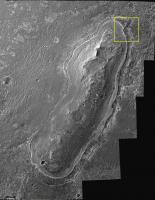
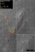
Cape York - Shoemaker Ridge and the NE traverse, Starting sol 2735 |

  |
Cape York - Shoemaker Ridge and the NE traverse, Starting sol 2735 |
 Oct 4 2011, 12:20 PM Oct 4 2011, 12:20 PM
Post
#1
|
||
 The Poet Dude  Group: Moderator Posts: 5551 Joined: 15-March 04 From: Kendal, Cumbria, UK Member No.: 60 |
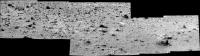
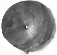
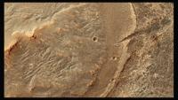
Oppy's next destination - the Shoemaker Ridge...
(3D version here http://roadtoendeavour.files.wordpress.com/2011/10/sr-3d.jpg ) Some more height...surrounded by lots of gorgeous rocks...view right across Endeavour... our first view too, probably, of the Promised Land in the centre of Cape York where the phylosillicates are waiting to be found... Go get 'em, Oppy!  Edit: looks like Oppy's on the move... http://qt.exploratorium.edu/mars/opportuni...84P1211L0M1.JPG -------------------- |
|
 |
 
|
|
|
Oct 4 2011, 02:23 PM
Post
#2
|
|
 Senior Member Group: Members Posts: 4247 Joined: 17-January 05 Member No.: 152 |
It looks like the 2735 move was towards the west, ie towards Odyssey crater, instead of directly towards Shoemaker ridge (north). Positioning for a drive north, or checking out Odyssey ejecta - we'll find out soon enough.
Edit: my guess is checking out Odyssey ejecta, since directly north looked totally drivable. |
|
|
|
|
Oct 4 2011, 05:36 PM
Post
#3
|
|
|
Senior Member Group: Members Posts: 2998 Joined: 30-October 04 Member No.: 105 |
QUOTE (Bill Harris @ Oct 2 2011, 08:41 AM)  <snips> The outcrop Skead Kirkland Lake is one we've drooled at before and is an interesting-looking exposure. Why is there an unusual purplish iridescent sheen to the rock? I'll guess it's a weathering phenomenon, which is the important step in turning silicate rocks into clays. Wouldn't hurt to have a closer look-- not necessarily a full IDD session, but a series of close-in Pancams would be peachy. http://i142.photobucket.com/albums/r91/wil...19P2398L2M1.jpg Oppy moved today, and as suggested, the move is to outcrop Skead Kirkland Lake to the west, which is near Odyssey ejecta. A few sols drooling on that outcrop, then off to the Shoemaker Ridge site for looks at what I'm naming informally on my end "the Allen Formation". And some interesting imagery in the data pipeline today, so stay tuned... --Bill -------------------- |
|
|
|
|
Oct 5 2011, 12:32 PM
Post
#4
|
||
|
Senior Member Group: Members Posts: 1074 Joined: 21-September 07 From: Québec, Canada Member No.: 3908 |
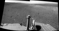
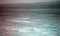
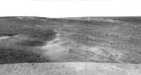
Navcam panorama of Oppy's position on sol 2735.
|
|
|
|
|
|
|
Oct 5 2011, 07:45 PM
Post
#5
|
||
|
Senior Member Group: Members Posts: 2830 Joined: 22-April 05 From: Ridderkerk, Netherlands Member No.: 353 |
The Pancam L2 view from Sol 2735 and 2736
stitched together. Jan van Driel
|
|
|
|
|
|
|
Oct 6 2011, 02:13 PM
Post
#6
|
|
|
Senior Member Group: Members Posts: 4247 Joined: 17-January 05 Member No.: 152 |
Looks like a good drive roughly to the north (away from Tribulation) on 2737:
http://qt.exploratorium.edu/mars/opportuni...0M1.JPG?sol2737 I guess they only wanted to do some quick imaging at the previous site close to Odyssey. |
|
|
|
|
Oct 6 2011, 02:49 PM
Post
#7
|
|
|
Senior Member Group: Members Posts: 2998 Joined: 30-October 04 Member No.: 105 |
It looks as though they're heading along the ridgetop upslope of "BostonCreek LarderLake". I was hoping to get a peek at the finely-bedded strata. Next area of interest may be that light-toned rectangular pattern on the way to the "summit crater" with the CRISM clays.
--Bill -------------------- |
|
|
|
|
Oct 6 2011, 06:07 PM
Post
#8
|
|
|
Senior Member Group: Moderator Posts: 4279 Joined: 19-April 05 From: .br at .es Member No.: 253 |
Looking north on this image, CY looks almost flat and featureless.
http://qt.exploratorium.edu/mars/opportuni...CVP1966L0M1.JPG |
|
|
|
|
Oct 6 2011, 06:12 PM
Post
#9
|
||
|
Senior Member Group: Members Posts: 2830 Joined: 22-April 05 From: Ridderkerk, Netherlands Member No.: 353 |
The Navcam L0 view in the drive direction on Sol 2737.
Jan van Driel
|
|
|
|
|
|
|
Oct 6 2011, 07:51 PM
Post
#10
|
||
|
Senior Member Group: Members Posts: 4247 Joined: 17-January 05 Member No.: 152 |
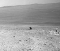
This looks like a precariously perched rock:
But my guess is the lower left side of the rock looks like background when it's really part of the rock. |
|
|
|
|
|
|
Oct 6 2011, 09:26 PM
Post
#11
|
|
|
Senior Member Group: Members Posts: 3516 Joined: 4-November 05 From: North Wales Member No.: 542 |
QUOTE (fredk @ Oct 6 2011, 08:51 PM) a precariously perched rock Hey, let's go and give it a shove!  I know, I've got this irrational urge to look under rocks. I think it comes from playing on the beach as a child. I know, I've got this irrational urge to look under rocks. I think it comes from playing on the beach as a child.
|
|
|
|
|
Oct 7 2011, 02:39 AM
Post
#12
|
|
|
Junior Member Group: Members Posts: 98 Joined: 17-July 11 From: Pasadena, CA Member No.: 6066 |
QUOTE (Bill Harris @ Oct 6 2011, 06:49 AM) It looks as though they're heading along the ridgetop upslope of "BostonCreek LarderLake". I was hoping to get a peek at the finely-bedded strata. Next area of interest may be that light-toned rectangular pattern on the way to the "summit crater" with the CRISM clays. --Bill Yeah, we're boogeying on out to Shoemaker Ridge as fast as we can. We need to do a detailed in-situ survey of north-facing slopes and plan out some lily-pads to take us through the Winter solstice (03/31/11). Among other things. -m |
|
|
|
|
Oct 7 2011, 03:01 AM
Post
#13
|
||
|
Member Group: Members Posts: 808 Joined: 10-October 06 From: Maynard Mass USA Member No.: 1241 |
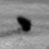
10x precariously perched rock (noise cancel on stretched jpg ... argg)
-------------------- CLA CLL
|
|
|
|
|
|
|
Oct 7 2011, 04:52 AM
Post
#14
|
|
|
Senior Member Group: Members Posts: 2998 Joined: 30-October 04 Member No.: 105 |
Ah, I remember reading about the need to winter-over on a north-facing slope this year, so a boogie makes more sense than a mosey. Whatever we zip by now can be revisited on the return trip to Tribulation...
--Bill -------------------- |
|
|
|
|
Oct 7 2011, 05:58 AM
Post
#15
|
|
 Senior Member Group: Members Posts: 2228 Joined: 1-December 04 From: Marble Falls, Texas, USA Member No.: 116 |
QUOTE (PDP8E @ Oct 6 2011, 09:01 PM) 10x precariously perched rock (noise cancel on stretched jpg ... argg) It looks like Nessie to me. -------------------- ...Tom
I'm not a Space Fan, I'm a Space Exploration Enthusiast. |
|
|
|
|
Oct 7 2011, 06:02 AM
Post
#16
|
|
 Senior Member Group: Moderator Posts: 3431 Joined: 11-August 04 From: USA Member No.: 98 |
Here's the Sol 2737 Pancam mosaic anaglyph. Watch out for that shallow crater, Oppy.
|
|
|
|
|
Oct 7 2011, 06:45 AM
Post
#17
|
|
|
Senior Member Group: Members Posts: 2086 Joined: 13-February 10 From: Ontario Member No.: 5221 |
At the far north-east corner is that odd straight 'cut' or 'slash' in the side of CY, right? Would be nice to look at while wintering over (assuming I didn't miss a consensus on it being something completely ordinary).
|
|
|
|
|
Oct 7 2011, 09:52 AM
Post
#18
|
|||
 Senior Member Group: Members Posts: 1088 Joined: 19-February 05 From: Close to Meudon Observatory in France Member No.: 172 |
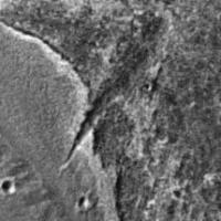
QUOTE (Explorer1 @ Oct 7 2011, 08:45 AM) At the far north-east corner is that odd straight 'cut' or 'slash' in the side of CY, right? Would be nice to look at while wintering over (assuming I didn't miss a consensus on it being something completely ordinary). ==> Are you speaking of "Dagger Valley" ?
|
||
|
|
|
||
|
Oct 7 2011, 02:13 PM
Post
#19
|
|
|
Senior Member Group: Members Posts: 4247 Joined: 17-January 05 Member No.: 152 |
It looks like another substantial drive northish on 2738:
http://qt.exploratorium.edu/mars/opportuni...0M1.JPG?sol2738 This should put us in a good spot to image the north-facing slopes of Shoemaker ridge. |
|
|
|
|
Oct 7 2011, 03:37 PM
Post
#20
|
||
|
Senior Member Group: Moderator Posts: 3431 Joined: 11-August 04 From: USA Member No.: 98 |
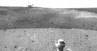
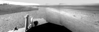
This isn't precisely accurate (unless the rover is hovering), but sort of pretty:
Attached thumbnail(s)
|
|
|
|
|
|
|
Oct 7 2011, 06:00 PM
Post
#21
|
|
|
The Poet Dude Group: Moderator Posts: 5551 Joined: 15-March 04 From: Kendal, Cumbria, UK Member No.: 60 |
Wow... every time you do that I get a real slap-across-the-face reality check... looking at the pictures on their own, with no rover for scale, it's easy to fool yourself into thinking Oppy is much, much smaller, or the landscape is much more, I don't know... epic? You plonk her down amidst the dunes and dust and suddenly everything seems smaller. Anyone else feel that?

-------------------- |
|
|
|
|
Oct 7 2011, 07:09 PM
Post
#22
|
|
|
Senior Member Group: Members Posts: 2920 Joined: 14-February 06 From: Very close to the Pyrénées Mountains (France) Member No.: 682 |
I agree Stu...but mind...it's gona be "worse" with Curiosity!
-------------------- |
|
|
|
|
Oct 7 2011, 07:21 PM
Post
#23
|
||
|
Senior Member Group: Moderator Posts: 3431 Joined: 11-August 04 From: USA Member No.: 98 |
QUOTE (Stu @ Oct 7 2011, 11:00 AM) Anyone else feel that? I've always found it incredibly difficult to judge the scale of things the rovers are seeing, which, thinking back, is why I put Doug's model in my program to begin with. But if one extends the view to the right, I think it's epic enough
Attached thumbnail(s)
|
|
|
|
|
|
|
Oct 7 2011, 07:57 PM
Post
#24
|
||
|
Senior Member Group: Members Posts: 4247 Joined: 17-January 05 Member No.: 152 |
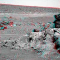
Shoemaker Ridge looks pretty subtle from this side:
|
|
|
|
|
|
|
Oct 7 2011, 09:54 PM
Post
#25
|
|
|
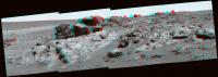
Senior Member Group: Members Posts: 3516 Joined: 4-November 05 From: North Wales Member No.: 542 |
Really beautiful (and obviously well constructed) 3D view. Never mind the ridge, look at the vista.
|
|
|
|
|
Oct 8 2011, 12:16 AM
Post
#26
|
|
|
Senior Member Group: Members Posts: 2086 Joined: 13-February 10 From: Ontario Member No.: 5221 |
Yes vikingmars, that's what I meant.
Does it have an official name yet? It certainly stands out enough. |
|
|
|
|
Oct 8 2011, 12:57 PM
Post
#27
|
|
|
Senior Member Group: Members Posts: 1088 Joined: 19-February 05 From: Close to Meudon Observatory in France Member No.: 172 |
QUOTE (Explorer1 @ Oct 8 2011, 02:16 AM) Yes vikingmars, that's what I meant. Does it have an official name yet? It certainly stands out enough. No official name yet : this is the name we gave this feature at Societe Astronomique de France, because it looks like a dagger made out of hard rock by cavemen as seen oftenly in our paleontology museums...
|
|
|
|
|
Oct 8 2011, 04:50 PM
Post
#28
|
|
|
Senior Member Group: Moderator Posts: 3431 Joined: 11-August 04 From: USA Member No.: 98 |
|
|
|
|
|
Oct 8 2011, 09:21 PM
Post
#29
|
||
|
The Poet Dude Group: Moderator Posts: 5551 Joined: 15-March 04 From: Kendal, Cumbria, UK Member No.: 60 |
Love these low Sun angle views...
-------------------- |
|
|
|
|
|
|
Oct 8 2011, 10:25 PM
Post
#30
|
||
|
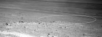
Senior Member Group: Members Posts: 4247 Joined: 17-January 05 Member No.: 152 |
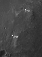
My estimate of our location after the 2739 drive:
It looks like a long drive (over 70 metres!). We should be able to map out the next group of north-facing slopes from around here. And judging from the rear hazcam view, we should now have a direct view of the putative clay-bearing region. Can't wait for the nav/pancams... |
|
|
|
|
|
|
Oct 9 2011, 05:55 AM
Post
#31
|
||
|
The Poet Dude Group: Moderator Posts: 5551 Joined: 15-March 04 From: Kendal, Cumbria, UK Member No.: 60 |
QUOTE (fredk @ Oct 8 2011, 11:25 PM) And judging from the rear hazcam view, we should now have a direct view of the putative clay-bearing region. Can't wait for the nav/pancams... I think you're right... two new pancams down so far, one (L) shows, I think, those 'rectangular markings'. Little clearer when stretched...
So Oppy sailed right past the Shoemaker Ridge and is going after the Good Stuff, eh? -------------------- |
|
|
|
|
|
|
Oct 9 2011, 06:17 AM
Post
#32
|
|
|
Senior Member Group: Moderator Posts: 3431 Joined: 11-August 04 From: USA Member No.: 98 |
QUOTE (Stu @ Oct 8 2011, 10:55 PM) two new pancams down so far That's still before the drive. Opportunity is now supposed to be on the left side of that image, with what might be a pretty interesting view. Looks like she's moving right along, yes. |
|
|
|
|
Oct 9 2011, 06:50 AM
Post
#33
|
|
|
The Poet Dude Group: Moderator Posts: 5551 Joined: 15-March 04 From: Kendal, Cumbria, UK Member No.: 60 |
They were *before* the drive? Sorry, should have checked the image reg. Anyway, even better, we should get a really good view of The Promised Land in the next batch...
-------------------- |
|
|
|
|
Oct 9 2011, 08:39 AM
Post
#34
|
||
|
Senior Member Group: Members Posts: 2830 Joined: 22-April 05 From: Ridderkerk, Netherlands Member No.: 353 |
The Navcam L0 view on Sol 2738.
Jan van Driel
|
|
|
|
|
|
|
Oct 9 2011, 08:52 AM
Post
#35
|
||
|
Senior Member Group: Members Posts: 2830 Joined: 22-April 05 From: Ridderkerk, Netherlands Member No.: 353 |
and the Pancam L2 view on Sol 2738.
Jan van Driel
|
|
|
|
|
|
| Guest_Oersted_* |
Oct 9 2011, 02:56 PM
Post
#36
|
|
Guests |
The slopes up ahead look promising for opportunities to tilt the rover before the impending winter. When is it more or less that we need to do that, btw?
Thx for the stitches! |
|
|
|
|
Oct 9 2011, 06:37 PM
Post
#37
|
|
|
Member Group: Members Posts: 194 Joined: 3-January 10 Member No.: 5156 |
Funny, instead of slowly driving north to search for the clays they rush in highspeed over Cape York. Cool, and that will give every day new views of this place.
I'm really interested how the clays and phyllosilicates look from the bottom! Will they have a distinct visible structure or are they just as rocks as we all have seen the last years? -------------------- Need more input ...
|
|
|
|
|
Oct 9 2011, 07:53 PM
Post
#38
|
|
|
Senior Member Group: Members Posts: 4247 Joined: 17-January 05 Member No.: 152 |
Yeah, my impression is they want to map out any north-facing slopes now, while they still have plenty of power to drive, in case they need them this winter. And the closer to the clays the better. So it looks like science is on hold for now. But that may change as soon as they decide they've found good slopes.
QUOTE (Oersted @ Oct 9 2011, 03:56 PM) When is it more or less that we need to do that, btw? They don't know yet if they'll need to park at all. It depends on the dust. Check out the latest PS update for some comments about this. |
|
|
|
|
Oct 9 2011, 08:12 PM
Post
#39
|
|||
|
Junior Member Group: Members Posts: 24 Joined: 17-March 05 From: Minneapolis Member No.: 208 |
By my estimate, we're now on the southern edge of the phyllosilicates. Compare Tesheiner's map for 2739 (today) and the phyllosilicate signatures (red) in CRISM:
|
||
|
|
|
||
|
Oct 9 2011, 08:15 PM
Post
#40
|
||
|
Senior Member Group: Moderator Posts: 3431 Joined: 11-August 04 From: USA Member No.: 98 |
A single Navcam image has made it to the web - one which isn't particularly illuminating, LOL. If it helps (probably not), the right side of that image is facing North.
Here's where the tracking data says the rover is:
Attached thumbnail(s)
|
|
|
|
|
|
|
Oct 9 2011, 10:42 PM
Post
#41
|
|
|
Senior Member Group: Members Posts: 2920 Joined: 14-February 06 From: Very close to the Pyrénées Mountains (France) Member No.: 682 |
I'm a bit confused not to stay "lost". On Eduardo's map, I have no doubt North is "UP". So, I see East facing slopes on pictures and no North facing slopes unless Oppy is decending at this time. Can somebody tell me what's wrong with this?
-------------------- |
|
|
|
|
Oct 9 2011, 11:25 PM
Post
#42
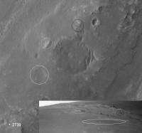
|
||
|
Senior Member Group: Members Posts: 4247 Joined: 17-January 05 Member No.: 152 |
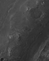
I'm not sure if this will help, but generally the slopes are east facing here, although there are some "knobs" that might have north-facing slopes of varying degrees, that I've circled here:
I'm thinking those are the areas they want to map carefully. |
|
|
|
|
|
|
Oct 10 2011, 02:23 AM
Post
#43
|
|
|
Senior Member Group: Members Posts: 2998 Joined: 30-October 04 Member No.: 105 |
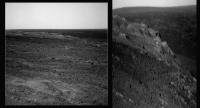
Interesting place, this Ridge of Shoemaker. FIrst loook, a different particle size and shape distribution in the soil, and look st the rounded cobbles.
http://qt.exploratorium.edu/mars/opportuni...00P0600L0M1.JPG --Bill -------------------- |
|
|
|
|
Oct 10 2011, 02:35 AM
Post
#44
|
|
|
Senior Member Group: Moderator Posts: 3431 Joined: 11-August 04 From: USA Member No.: 98 |
|
|
|
|
|
Oct 10 2011, 04:24 AM
Post
#45
|
|
|
Senior Member Group: Members Posts: 2228 Joined: 1-December 04 From: Marble Falls, Texas, USA Member No.: 116 |
QUOTE (Bill Harris @ Oct 9 2011, 08:23 PM) ... and look at the rounded cobbles. ... Those are curious, aren't they?
-------------------- ...Tom
I'm not a Space Fan, I'm a Space Exploration Enthusiast. |
|
|
|
|
Oct 10 2011, 04:38 AM
Post
#46
|
|
|
Senior Member Group: Members Posts: 4247 Joined: 17-January 05 Member No.: 152 |
Yep - I don't recall a group of globby cobbles quite like that.
This frame's looking farther up CY towards the main clay signature area: http://qt.exploratorium.edu/mars/opportuni...0M1.JPG?sol2740 |
|
|
|
|
Oct 10 2011, 04:54 AM
Post
#47
|
|
|
Senior Member Group: Moderator Posts: 3431 Joined: 11-August 04 From: USA Member No.: 98 |
Where do you even start with a place like this? Will be interesting to see what happens next.
Edit: Well, start with some Pancam, hopefully
|
|
|
|
|
Oct 10 2011, 05:13 AM
Post
#48
|
|
|
Senior Member Group: Moderator Posts: 3431 Joined: 11-August 04 From: USA Member No.: 98 |
Here's a version of the 360x80 degree Navcam anaglyph with image sharpened and focal point a bit farther out. (I'm fascinated by the topography to the north-northeast.)
|
|
|
|
|
Oct 10 2011, 06:05 AM
Post
#49
|
|
|
Senior Member Group: Members Posts: 2998 Joined: 30-October 04 Member No.: 105 |
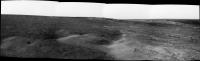
Curious, yes. Note that the cobbles all have a light area on one end. First thought was "ah, a specular reflection", but in an L0 Navcam, light=reddish so it's an "ocher" spot. Given the orientation, they seem to be in the "downwind" direction so it's in a wind-dead zone and light particles tend to collect and adhere or beind downwind, there is less aeolian abrasion and erosion. And in fredk's Navcam view, look at the ripple-forming sand plus the rounded cobbles, with a mix of particles like that, this is a area of active weathering and erosion. Unique area, and we've just now gotten here.
I'm hoping for a sidetrip to the spot with those rectangular lineations (which I'm informally calling "Secular City" til we get an official name) for a quick peek and close-in color views. That fascinating topography is in the direction of the dark-filled crater, "summit crater", informally. --Bill -------------------- |
|
|
|
|
Oct 10 2011, 06:48 AM
Post
#50
|
|
|
Senior Member Group: Moderator Posts: 4279 Joined: 19-April 05 From: .br at .es Member No.: 253 |
|
|
|
|
|
Oct 10 2011, 11:11 AM
Post
#51
|
|
|
Senior Member Group: Members Posts: 2998 Joined: 30-October 04 Member No.: 105 |
Good application of a circular panorama.
Compare with Phil's Cir_Pan of Mike's Sol-2710 Navcam pan: http://www.unmannedspaceflight.com/index.p...st&id=25510 (in post http://www.unmannedspaceflight.com/index.p...st&p=178440 ) -- you can tell we are no longer on the side of a hill, and you can just make out "summit crater" to the NNE. --Bill EDIT: and with Phil's current circular pan two posts down: http://www.unmannedspaceflight.com/index.p...st&id=25663 . Same data, different perspectives. -------------------- |
|
|
|
|
Oct 10 2011, 01:15 PM
Post
#52
|
|
|
Senior Member Group: Members Posts: 2920 Joined: 14-February 06 From: Very close to the Pyrénées Mountains (France) Member No.: 682 |
QUOTE (fredk @ Oct 10 2011, 01:25 AM) I'm not sure if this will help, but generally the slopes are east facing here, although there are some "knobs" that might have north-facing slopes of varying degrees, that I've circled here: I'm thinking those are the areas they want to map carefully. I've got the point , thanks Fredk, this make sense now. -------------------- |
|
|
|
|
Oct 10 2011, 01:38 PM
Post
#53
|
||
|
Solar System Cartographer Group: Members Posts: 10164 Joined: 5-April 05 From: Canada Member No.: 227 |
My version of mhoward's nice panorama in circular form.
Phil
-------------------- ... because the Solar System ain't gonna map itself.
Also to be found posting similar content on https://mastodon.social/@PhilStooke Maps for download (free PD: https://upload.wikimedia.org/wikipedia/comm...Cartography.pdf NOTE: everything created by me which I post on UMSF is considered to be in the public domain (NOT CC, public domain) |
|
|
|
|
|
|
Oct 10 2011, 04:59 PM
Post
#54
|
|
|
Senior Member Group: Members Posts: 2998 Joined: 30-October 04 Member No.: 105 |
I uploaded to the PhotoBucket site an index image of the area between Odyssey Crater and the "unnamed summit crater" in the CRISM clay area, in PNG format.
HiRISE image of part of Cape York, at Endeavour Crater. Cropped, sharpened and enhanced and map oriented. Covers MER traverse from Odyssey Crater to CRISM clay area Image ESP_024015_1775 _RED http://i142.photobucket.com/albums/r91/wil...maker_Ridge.png Somewhat grainy-looking, but I've concluded that this is due to sub-pixel light spots and dark cobbles on the ground pushing the average pixel value up or down. You can orient yourself using Tesheiner's Route Maps or with the Cir_Pans uploaded earlier. --Bill -------------------- |
|
|
|
| Guest_Sunspot_* |
Oct 10 2011, 05:22 PM
Post
#55
|
|
Guests |
Do those rectangular features correspond to the clay signature?
|
|
|
|
|
Oct 10 2011, 05:38 PM
Post
#56
|
|
|
Member Group: Members Posts: 910 Joined: 4-September 06 From: Boston Member No.: 1102 |
Nope, just the foundation stones of the old fort.

-------------------- |
|
|
|
|
Oct 10 2011, 07:10 PM
Post
#57
|
||
 Senior Member Group: Admin Posts: 4763 Joined: 15-March 05 From: Glendale, AZ Member No.: 197 |
Now we know where it landed after it was sent spinning.
Attached thumbnail(s)
-------------------- If Occam had heard my theory, things would be very different now.
|
|
|
|
|
|
|
Oct 10 2011, 08:12 PM
Post
#58
|
||
|
Senior Member Group: Members Posts: 4247 Joined: 17-January 05 Member No.: 152 |
Nice view from sol 2736 showing Odyssey ejecta, then Odyssey itself, then Spirit Point on CY, and finally the jumbled terrain we zoomed over on our way in...
|
|
|
|
|
|
|
Oct 10 2011, 10:23 PM
Post
#59
|
||
|
Senior Member Group: Moderator Posts: 3431 Joined: 11-August 04 From: USA Member No.: 98 |
Not seamless, but... (Sol 2736 "Kirkland Lake" red-cyan anaglyph)
Attached thumbnail(s)
|
|
|
|
|
|
|
Oct 11 2011, 12:19 AM
Post
#60
|
|
|
Member Group: Members Posts: 204 Joined: 14-April 06 From: Seattle, WA Member No.: 745 |
QUOTE (Bill Harris @ Oct 9 2011, 10:05 PM) I'm hoping for a sidetrip to the spot with those rectangular lineations (which I'm informally calling "Secular City" til we get an official name) for a quick peek and close-in color views. Those 'rectangular lineations' look a lot like the cemented fractures in Gale Crater. Description of cemented fractures.  They don't say anything about clay in the image caption, but it is evidence of water. My guess the MER team will want to take a look at this feature; maybe Oppy will scoop MSL. Anyway, I hope so too. Go Oppy, go! 
|
|
|
|
|
Oct 11 2011, 12:19 AM
Post
#61
|
||
|
The Poet Dude Group: Moderator Posts: 5551 Joined: 15-March 04 From: Kendal, Cumbria, UK Member No.: 60 |
QUOTE (ElkGroveDan @ Oct 10 2011, 08:10 PM) Now we know where it landed after it was sent spinning. Close, Dan, but I think this is more likely...
 -------------------- |
|
|
|
|
|
|
Oct 11 2011, 12:36 AM
Post
#62
|
|
|
Senior Member Group: Members Posts: 2998 Joined: 30-October 04 Member No.: 105 |
And the P2405 sequence images today from Sol -2739 named "Sutherland Knobbys" is to the southeast and shows just the edge of the rectangular lineations. They are still mostly hidden by the ridge.
http://qt.exploratorium.edu/mars/opportuni...G8P2405L2M1.JPG and http://qt.exploratorium.edu/mars/opportuni...G8P2405L2M1.JPG "Sutherland Knobbys" is an interesting bit of Aussie history-- http://coalriver.wordpress.com/2011/08/18/...s-head-on-mars/ The prominent ridge in the second image is actually Sutherland Point in Botany Bay and Knobbys Head is behind it. Or so I think. --Bill -------------------- |
|
|
|
|
Oct 11 2011, 12:38 AM
Post
#63
|
|
 Member Group: Members Posts: 399 Joined: 28-August 07 From: San Francisco Member No.: 3511 |
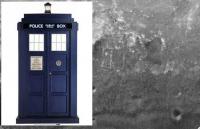
Don't want to Tar dis thread but... I hope we can investigate those features
...
-------------------- 'She drove until the wheels fell off...'
|
|
|
|
|
Oct 11 2011, 12:48 AM
Post
#64
|
||
|
Senior Member Group: Members Posts: 4247 Joined: 17-January 05 Member No.: 152 |
QUOTE (Bill Harris @ Oct 11 2011, 12:36 AM) And the P2405 sequence images today from Sol -2739 named "Sutherland Knobbys" is to the southeast and shows just the edge of the rectangular lineations. They are still mostly hidden by the ridge. I'd say that pancam sequence is looking more S-SW, well away from the "lineations". But the lineations are just visible in the navcams, here:
Obviously we'll need pancams (or to drive closer!) to make out any detail. |
|
|
|
|
|
|
Oct 11 2011, 12:51 AM
Post
#65
|
|
|
Senior Member Group: Members Posts: 2998 Joined: 30-October 04 Member No.: 105 |
QUOTE (Ron_Hobbs) Those 'rectangular lineations' look a lot like the cemented fractures in Gale Crater May very well be-- my first thought on those was "cold water hydrothermal cementation along fractures", which is another way of saying "mineral-saturated groundwater once filled the fractures. The water deposited minerals on both sides of the opening". There have been several suggestions of "cold water hydrothermal" activity at Meridiani and this clinches it. --Bill -------------------- |
|
|
|
|
Oct 11 2011, 12:56 AM
Post
#66
|
|
|
Senior Member Group: Members Posts: 2998 Joined: 30-October 04 Member No.: 105 |
QUOTE (FredK) I'd say that pancam sequence is looking more S-SW, well away from the "lineations". Errr, could be. I'm getting a bit disoriented here, even with tracking data and orbital images.--Bill -------------------- |
|
|
|
|
Oct 11 2011, 01:24 AM
Post
#67
|
||
|
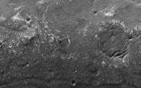
Senior Member Group: Members Posts: 4247 Joined: 17-January 05 Member No.: 152 |
Here's an identification of features to the NE, where the clay signatures lie:
(The inset is L/R registered average of the 2740 navcam, with 2x vertical stretch.) The circled outcrops could be our first peek at the rocks we've been seeking for so long... |
|
|
|
|
|
|
Oct 11 2011, 01:33 AM
Post
#68
|
|
|
Senior Member Group: Moderator Posts: 3431 Joined: 11-August 04 From: USA Member No.: 98 |
QUOTE (fredk @ Oct 10 2011, 07:24 PM) Here's an identification of features to the NE, where the clay signatures lie: Nice. And if it helps with orientation at all (which is indeed challenging), the 360 degree panorama I posted above is centered on north, as are the circular projections. |
|
|
|
|
Oct 11 2011, 03:21 AM
Post
#69
|
||
 Member Group: Members Posts: 404 Joined: 5-January 10 Member No.: 5161 |
Great new images of the Odyssey boulders have come down, looking forward to the mosaics (hope to learn how to make them myself one day). An example of the anaglyphs in store:
|
|
|
|
|
|
|
Oct 11 2011, 03:23 AM
Post
#70
|
|
|
Senior Member Group: Members Posts: 4247 Joined: 17-January 05 Member No.: 152 |
Yeah, I should say - I couldn't've made those ID's without your mosaic and the circular projections!
BTW, in case anyone isn't monitoring the website, the Endeavour approach movie has been compiled, with accelerometer soundtrack. Really nice. http://marsrovers.jpl.nasa.gov/newsroom/pr.../20111010a.html |
|
|
|
|
Oct 11 2011, 06:17 AM
Post
#71
|
|
|
Senior Member Group: Members Posts: 2228 Joined: 1-December 04 From: Marble Falls, Texas, USA Member No.: 116 |
This paper associates phyllosilicates with polygonal lineations in HiRise imagery, and offers some other interesting observations regarding the directions that some of the layers dip.
QUOTE 3. Morphology and Stratigraphy
[10] Images of the phyllosilicate-bearing crater rim segments from the MRO High Resolution Imaging Science Experiment (HiRISE) [McEwen et al., 2007] reveal layering and a range of polygonal textures (Figure 3a), similar in appearance to other phyllosilicate-bearing outcrops in Meridiani [Wiseman et al., 2008; Marzo et al., 2009] and many other locations on Mars [e.g., Wray et al., 2008; Bishop et al., 2008; Ehlmann et al., 2009]. Stereo views (Figure 3b) show that layers within the western rim dip away from the crater interior, as expected if the beds predate Endeavour crater and were back-tilted by the impact. In contrast, bright layers bounding many Endeavour rim segments [e.g., McEwen et al., 2009, Figure 29] dip down toward the crater interior; we cannot clearly determine whether these layers predate or postdate the impact based on orbital images. -------------------- ...Tom
I'm not a Space Fan, I'm a Space Exploration Enthusiast. |
|
|
|
|
Oct 11 2011, 12:32 PM
Post
#72
|
|
|
Senior Member Group: Members Posts: 1074 Joined: 21-September 07 From: Québec, Canada Member No.: 3908 |
QUOTE (walfy @ Oct 10 2011, 11:21 PM) Great new images of the Odyssey boulders have come down, looking forward to the mosaics. See this post. QUOTE (walfy @ Oct 10 2011, 11:21 PM) (hope to learn how to make them myself one day). Try, for example, Photoshop Elements. There are also other software, free and commercial, out there. A Google search will come up with plenty of information. |
|
|
|
|
Oct 11 2011, 02:56 PM
Post
#73
|
|
|
Senior Member Group: Members Posts: 4247 Joined: 17-January 05 Member No.: 152 |
QUOTE (CosmicRocker @ Oct 11 2011, 06:17 AM) This paper associates phyllosilicates with polygonal lineations in HiRise imagery Thanks for reminding us of that paper, Rocker. And Fig 3c in that paper shows the very polygons we're sitting next to right now!So we know they'll be interested in them. And yesterday there was this cryptic message from Maxwell: QUOTE Driving Opportunity with Tara today. No real obstacles to avoid, but at least our path is zig-zaggy, a nice change of pace from the plains. I can't wait to find out where we're going!( |
|
|
|
|
Oct 11 2011, 07:03 PM
Post
#74
|
||
|
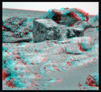
The Poet Dude Group: Moderator Posts: 5551 Joined: 15-March 04 From: Kendal, Cumbria, UK Member No.: 60 |
Colour mosaic, showing lots of rugged rocky goodness...
-------------------- |
|
|
|
|
|
|
Oct 11 2011, 08:00 PM
Post
#75
|
|
|
Senior Member Group: Members Posts: 1583 Joined: 14-October 05 From: Vermont Member No.: 530 |
Are those clouds? I know the vertical stuff is dust, but there's a horizontal banding in there. Just fill?
|
|
|
|
|
Oct 11 2011, 08:17 PM
Post
#76
|
|
|
The Poet Dude Group: Moderator Posts: 5551 Joined: 15-March 04 From: Kendal, Cumbria, UK Member No.: 60 |
QUOTE (stevesliva @ Oct 11 2011, 09:00 PM) Are those clouds? I know the vertical stuff is dust, but there's a horizontal banding in there. Just fill? Lot of fill at the top, well spotted. Just look at the rocky stuff.  -------------------- |
|
|
|
|
Oct 11 2011, 08:22 PM
Post
#77
|
|
|
Senior Member Group: Members Posts: 4247 Joined: 17-January 05 Member No.: 152 |
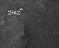
No time to check, but it looks like we've driven up to the lineations, and they're visible clearly in the navcams now:
http://qt.exploratorium.edu/mars/opportuni...0M1.JPG?sol2742 |
|
|
|
|
Oct 11 2011, 08:24 PM
Post
#78
|
||
|
The Poet Dude Group: Moderator Posts: 5551 Joined: 15-March 04 From: Kendal, Cumbria, UK Member No.: 60 |
Oooooohhhh....

-------------------- |
|
|
|
|
|
|
Oct 11 2011, 09:11 PM
Post
#79
|
||
|
The Poet Dude Group: Moderator Posts: 5551 Joined: 15-March 04 From: Kendal, Cumbria, UK Member No.: 60 |
Just to give a sense of scale of these features, here's a cloned Oppy shown next to them ...
-------------------- |
|
|
|
|
|
|
Oct 11 2011, 09:42 PM
Post
#80
|
|
 Senior Member Group: Moderator Posts: 2262 Joined: 9-February 04 From: Melbourne - Oz Member No.: 16 |
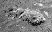
My version of the Kirkland Lake mosaic:
 That is some impressive rock pile! James -------------------- |
|
|
|
|
Oct 11 2011, 09:59 PM
Post
#81
|
|
|
Senior Member Group: Members Posts: 3516 Joined: 4-November 05 From: North Wales Member No.: 542 |
[quote name='fredk' date='Oct 11 2011, 09:22 PM' post='179180']
"we've driven up to the lineations, and they're visible clearly in the navcams now" Where are they in that image then? Can you point them out? Sorry not to have done my homework. |
|
|
|
|
Oct 11 2011, 11:09 PM
Post
#82
|
|
|
Senior Member Group: Moderator Posts: 3431 Joined: 11-August 04 From: USA Member No.: 98 |
|
|
|
|
|
Oct 11 2011, 11:16 PM
Post
#83
|
|
|
Senior Member Group: Moderator Posts: 3431 Joined: 11-August 04 From: USA Member No.: 98 |
Because this area might just be of particular interest, here's a QuickTime VR of the Navcam panorama anaglyph (Sol 2742) (7.4 MB)
Edit: Worth noting: when you first open this, the view is pointing North. And the big inadvertent seam marks South. |
|
|
|
|
Oct 11 2011, 11:23 PM
Post
#84
|
|
|
Senior Member Group: Members Posts: 2998 Joined: 30-October 04 Member No.: 105 |
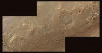
New enhanced crop of HiRISE image ESP_024015_1775 of the area surrounding the lineations:
http://i142.photobucket.com/albums/r91/wil...ecular_city.png --Bill -------------------- |
|
|
|
|
Oct 12 2011, 12:19 AM
Post
#85
|
|||
|
Senior Member Group: Members Posts: 4247 Joined: 17-January 05 Member No.: 152 |
QUOTE (fredk @ Oct 11 2011, 08:22 PM) No time to check, but it looks like we've driven up to the lineations I should've checked - we're still a ways short of the main lineations. Here's my best guess of the 2742 location - we appear to be sitting on the edge of a small depression/crater:
To my eye, the bright features in the middle of the navcam I posted look quite linear, but they're clearly much too close to be the main "tardis" features. The "tardis" features should be in this frame, roughly where I've circled:
Those nearby features may still be related lineations, just too small to see clearly on the hirise view. |
||
|
|
|
||
|
Oct 12 2011, 03:08 AM
Post
#86
|
||
|
Junior Member Group: Members Posts: 54 Joined: 10-August 11 Member No.: 6119 |
The 'back' of Stoughton,
Pancam sol 2736, L257 R2-1, Colour flicker gif with a synthesized right green channel (a la mhoward).
|
|
|
|
|
|
|
Oct 12 2011, 03:11 AM
Post
#87
|
|
|
Senior Member Group: Moderator Posts: 3431 Joined: 11-August 04 From: USA Member No.: 98 |
QUOTE (Jam Butty @ Oct 11 2011, 08:08 PM) Colour flicker gif with a synthesized right green channel Nice! |
|
|
|
|
Oct 12 2011, 04:05 AM
Post
#88
|
|
|
Senior Member Group: Members Posts: 2228 Joined: 1-December 04 From: Marble Falls, Texas, USA Member No.: 116 |
QUOTE (jamescanvin @ Oct 11 2011, 03:42 PM) That is some impressive rock pile! ... omg, that is sweet. I love this outcrop.-------------------- ...Tom
I'm not a Space Fan, I'm a Space Exploration Enthusiast. |
|
|
|
|
Oct 12 2011, 04:57 AM
Post
#89
|
|
|
Senior Member Group: Members Posts: 2228 Joined: 1-December 04 From: Marble Falls, Texas, USA Member No.: 116 |
This is some of the most amazing imagery we have ever seen of such ancient rocks.
-------------------- ...Tom
I'm not a Space Fan, I'm a Space Exploration Enthusiast. |
|
|
|
|
Oct 12 2011, 12:15 PM
Post
#90
|
|
|
Senior Member Group: Members Posts: 2998 Joined: 30-October 04 Member No.: 105 |
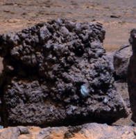
The lineations are indeed not readily visible from ground level. The sparse detritus overlying them "shields" the view at low viewing angles from the ground and blocks less in the "vertical" view of aerials. And they are undoubtedly mineralized joints or fractures, a form of low-temperature hydrothermal activity (a new word to bandy about). Probably created as stress-relief features from the unloading of the surface as the Endeavour rim has eroded (see them all the time in Appalachia) but they may also be related to shock from the concussion of the Endeavour impact (or earlier impacts). They are probably quite common here, but typically are less-visible and covered with the detritus of weathered material whereas at the spot the loose stuff has evidently been transported away. Notice that the Rover tracks sometimes disappear without an obvious change in the albedo or texture of the surface, so there is something different happening here.
Remember that we got a "preview" of lineations when we first arrived at CY and rushed by those fine, reddish lineations on the way to Odyssey. At any rate, the mineralogy of these structures will give great insight into conditions of the time. And a prequel of what cousin Curiosity ought to be looking at in Gale crater. --Bill -------------------- |
|
|
|
|
Oct 12 2011, 12:27 PM
Post
#91
|
||
|
Senior Member Group: Members Posts: 2998 Joined: 30-October 04 Member No.: 105 |
QUOTE (CR) I love this outcrop Indeed-- there is so much happening here. --Bill
Attached thumbnail(s)
-------------------- |
|
|
|
|
|
|
Oct 12 2011, 01:29 PM
Post
#92
|
|||
|
The Poet Dude Group: Moderator Posts: 5551 Joined: 15-March 04 From: Kendal, Cumbria, UK Member No.: 60 |
Just for fun - but scale is correct - a couple of simulated HiRISE views of what Oppy would look like if she continued to head north, stopping at some scenic points along the way...
-------------------- |
||
|
|
|
||
|
Oct 12 2011, 02:25 PM
Post
#93
|
|
|
Senior Member Group: Members Posts: 4247 Joined: 17-January 05 Member No.: 152 |
Nice post about the current mapping strategy at Lenda's blog.
Also some new maps, which split Shoemaker ridge into "A" and "B" (we're currently near B ). |
|
|
|
|
Oct 12 2011, 02:45 PM
Post
#94
|
|
|
Senior Member Group: Members Posts: 2998 Joined: 30-October 04 Member No.: 105 |
Neat. Does anyone know a public source for the topo map in Matt Lenda's late blog entry?
http://1.bp.blogspot.com/-F_1LEola0VQ/TpUK...labels_2742.png 'Twould be nice to be able to snag those from time to time... --Bill -------------------- |
|
|
|
|
Oct 13 2011, 12:27 AM
Post
#95
|
||
|
Junior Member Group: Members Posts: 54 Joined: 10-August 11 Member No.: 6119 |
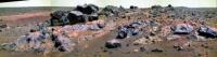
Small outcrop on Shoemaker Ridge 'B'
Navcam flicker gif, sol 2742.
|
|
|
|
|
|
|
Oct 13 2011, 05:48 AM
Post
#96
|
|
|
Senior Member Group: Members Posts: 2228 Joined: 1-December 04 From: Marble Falls, Texas, USA Member No.: 116 |
QUOTE (Bill Harris @ Oct 12 2011, 08:45 AM) Neat. Does anyone know a public source for the topo map in Matt Lenda's late blog entry?... Bill: I, too would like to find a source for that topo. We sometimes see some versions of that map at the Where are the Rovers now link at the JPL rover site. The OSU site is not very helpful in this regard.-------------------- ...Tom
I'm not a Space Fan, I'm a Space Exploration Enthusiast. |
|
|
|
|
Oct 13 2011, 06:07 AM
Post
#97
|
|
|
Senior Member Group: Members Posts: 2228 Joined: 1-December 04 From: Marble Falls, Texas, USA Member No.: 116 |
QUOTE Here context image! Take it! You'll need it! Matt: If you are going to post an image supporting a discussion about the need to find north facing slopes, you should either put a north arrow on your map, or you should follow the convention of making maps which have north at the top. Just a suggestion to make it easier for the rest us us to follow your line of reasoning.
-------------------- ...Tom
I'm not a Space Fan, I'm a Space Exploration Enthusiast. |
|
|
|
|
Oct 13 2011, 10:28 AM
Post
#98
|
|
|
Senior Member Group: Members Posts: 2998 Joined: 30-October 04 Member No.: 105 |
I wasn't able to find an "OSU" on the Web. The entity OSU is apparently a loose university consortium of photogrammetric genuises and GIS geeks and not a physical brick-and-mortar organization with a receptionist and front office. I suspect that they develop maps and charts on an as-needed contract basis.
But this is standard photogrammetric work, developing topo maps from stereo pairs. The hard part is making the grid of elevations from the aerials, but this work is done with the contours provided on the map. I'm retired but can probably call in favors on powerful gridding software-- once the elevations and map control points are entered into an autocad-like file it would be trivial to generate one's own topo maps. This can be a lot of work, but do-able as a hobby and I may try it for grins and giggles some day. Thanks to Matt for sharing this with us, and I surely wish we had a similar topo map of the adjacent area to the NE... --Bill -------------------- |
|
|
|
|
Oct 13 2011, 10:46 AM
Post
#99
|
|
|
Solar System Cartographer Group: Members Posts: 10164 Joined: 5-April 05 From: Canada Member No.: 227 |
OSU - Ohio State University, where Dr. Ron Li and his group have been involved in rover location finding and mapping since the start of the mission!
Phil http://shoreline.eng.ohio-state.edu/ron/_private/cv.html -------------------- ... because the Solar System ain't gonna map itself.
Also to be found posting similar content on https://mastodon.social/@PhilStooke Maps for download (free PD: https://upload.wikimedia.org/wikipedia/comm...Cartography.pdf NOTE: everything created by me which I post on UMSF is considered to be in the public domain (NOT CC, public domain) |
|
|
|
|
Oct 13 2011, 11:05 AM
Post
#100
|
|
|
Senior Member Group: Members Posts: 2998 Joined: 30-October 04 Member No.: 105 |
Yes, I saw Li's CV and know what OSU is and later found http://shoreline.eng.ohio-state.edu/ and even found this:
http://shoreline.eng.ohio-state.edu/album/...03/opp_2710.jpg --Bill -------------------- |
|
|
|
|

|
Lo-Fi Version | Time is now: 19th May 2024 - 07:43 AM |
|
RULES AND GUIDELINES Please read the Forum Rules and Guidelines before posting. IMAGE COPYRIGHT |
OPINIONS AND MODERATION Opinions expressed on UnmannedSpaceflight.com are those of the individual posters and do not necessarily reflect the opinions of UnmannedSpaceflight.com or The Planetary Society. The all-volunteer UnmannedSpaceflight.com moderation team is wholly independent of The Planetary Society. The Planetary Society has no influence over decisions made by the UnmannedSpaceflight.com moderators. |
SUPPORT THE FORUM Unmannedspaceflight.com is funded by the Planetary Society. Please consider supporting our work and many other projects by donating to the Society or becoming a member. |
|