Mercury Flyby 2 |

  |
Mercury Flyby 2 |
 Feb 8 2008, 10:50 PM Feb 8 2008, 10:50 PM
Post
#1
|
|
|
Member  Group: Members Posts: 540 Joined: 17-November 05 From: Oklahoma Member No.: 557 |
|
 |
 
|
|
Feb 8 2008, 11:02 PM
Post
#2
|
|
|
Member Group: Members Posts: 117 Joined: 7-December 06 From: Sheffield UK Member No.: 1462 |
One interesting feature MESSENGER will get a good look at during the second flyby is the area of Mercury's surface dubbed 'Weird Terrain.'
This jumbled region of the planet's surface is antipodal to Caloris and marks the focal point of seismic waves generated by the impact. Mariner 10 only saw half of this disturbed region, so I'm looking forward to seeing just how much havoc Caloris wreaked on the other side of Mercury. I wonder if a good look at the Weird Terrain will yeild any new info about Mercury's interior? (at least at the time of the Caloris impact). -------------------- It's a funny old world - A man's lucky if he gets out of it alive. - W.C. Fields.
|
|
|
|
|
Feb 9 2008, 02:28 AM
Post
#3
|
|
|
Senior Member Group: Members Posts: 1276 Joined: 25-November 04 Member No.: 114 |
Do we get any polar regions imaged during any of the flybys?
|
|
|
|
|
Feb 9 2008, 03:26 AM
Post
#4
|
|
 Junior Member Group: Members Posts: 56 Joined: 6-September 05 From: Paderborn, Germany Member No.: 484 |
That's something I'm also interested in
 . .
-------------------- --- Under Construction ---
|
|
|
|
|
Feb 9 2008, 10:41 AM
Post
#5
|
|
 Member Group: Members Posts: 146 Joined: 23-August 06 From: Vriezenveen, Netherlands Member No.: 1067 |
I think you'll have to wait for that till the orbital insertion.
|
|
|
|
|
Feb 9 2008, 02:35 PM
Post
#6
|
|
|
Member Group: Members Posts: 903 Joined: 30-January 05 Member No.: 162 |
I recognize there are some controversial views regarding the Deccan Traps and the Yucatan impact on earth.
Perhaps study of Caloris/weird terrain on Mercury might help us understand possible analogous structure(s) on earth ?? I also note, flyby 2 will be flown ~ 1 mile per second slower than flyby 1. More time for pictures and other goodies! |
|
|
|
|
Feb 10 2008, 01:38 AM
Post
#7
|
|
|
Member Group: Members Posts: 688 Joined: 20-April 05 From: Sweden Member No.: 273 |
QUOTE (tasp @ Feb 9 2008, 03:35 PM)  I recognize there are some controversial views regarding the Deccan Traps and the Yucatan impact on earth. That idea is simply not on for two good and sufficient reasons: 1. Deccan was not antipodal to Chicxulub 65 MY BP. 2. The Deccan Traps started ereupting well before the K/T boundary as proven by Maastrichtian fossils in the Intertrappan beds. tty |
|
|
|
|
Feb 10 2008, 04:53 AM
Post
#8
|
|
 Senior Member Group: Members Posts: 2530 Joined: 20-April 05 Member No.: 321 |
The flybys are all near-equatorial and, moreover, they are so close to the planet that the poles are permanently over the horizon near C/A.
Yet moreover, the interesting thing about the poles, that the bottoms of the craters may contain ice, is by definition something that can't be observed in sunlight, because they're never in sunlight. So far as Mariner 10 showed, there was nothing unusual in the visible areas of the poles. The interesting thing will be to see the elemental spectroscopy of the north pole where any hydrogen would make a strong signal (as it did on the Moon and Mars). That will have to wait for the orbital mission. The other possibility is that some other element like sulfur is the culprit. I'm betting on ice, though, which would mean that every body in the inner solar system besides Venus has water ice at its poles. Come to think of it, it's probably about a sweep in the outer solar system, too, besides Io. |
|
|
|
|
Feb 11 2008, 04:26 PM
Post
#9
|
|
|
Member Group: Members Posts: 220 Joined: 13-October 05 Member No.: 528 |
I was reading an article on Spacedaily, and ran across this real mathematical puzzler: "Observations during this second Messenger flyby will almost complete the first high-resolution viewing of Mercury, adding another one-third of the planet surface to the 21% of territory not seen by Mariner 10 and first imaged by Messenger in January 2008," says Messenger Project Scientist Ralph McNutt. I'm scratching my noggin over this one. He appears to be saying: Mariner 10 + Messenger Flyby 1 = 21% unimaged, aka. 79% coverage. But if you add another 33% coverage, you get 112% coverage, which can't be correct. Or, perhaps: Mariner 10 + Messenger Flyby 1 = 79% Coverage. Of the 21% left unimaged, Flyby 2 will get 1/3 of that missing coverage, aka 7%, so the total coverage will go up to 86%. Anyone want to chime in? |
|
|
|
|
Feb 11 2008, 05:52 PM
Post
#10
|
|
|
Senior Member Group: Members Posts: 2530 Joined: 20-April 05 Member No.: 321 |
Mariner 10 viewed 45% of Mercury. By these numbers, Flyby 1 added 21% and Flyby 2 added 33%, summing to 99%. That works. I think 33% is a bit of an overstatement, but speaking in fractions, 29% could be the real figure, giving a total of 95%.
I still think that's an overstatement, or at least it includes areas on the limb which aren't really being effectively resolved, but the gist is that we'll see more new stuff this time than we did last time. And when it's done, we'll have viewed the great majority of Mercury's surface. The catch is that it looks totally different depending on phase angle, so we're going to have to see everything at least twice before we've really seen it. But the orbital mission will ace that assignment. |
|
|
|
|
Feb 11 2008, 11:23 PM
Post
#11
|
|
|
Solar System Cartographer Group: Members Posts: 10164 Joined: 5-April 05 From: Canada Member No.: 227 |
I'm pretty sure it means 33% of the blank area. There should still be a sizeable strip left to fill in after Flyby 2, and Flyby 3 will not add anything much to it. That will have to wait until orbit.
Phil -------------------- ... because the Solar System ain't gonna map itself.
Also to be found posting similar content on https://mastodon.social/@PhilStooke Maps for download (free PD: https://upload.wikimedia.org/wikipedia/comm...Cartography.pdf NOTE: everything created by me which I post on UMSF is considered to be in the public domain (NOT CC, public domain) |
|
|
|
|
Jul 10 2008, 03:14 PM
Post
#12
|
|
|
Member Group: Members Posts: 540 Joined: 17-November 05 From: Oklahoma Member No.: 557 |
Just one year (88 earth days) to go.
|
|
|
|
|
Sep 7 2008, 03:23 AM
Post
#13
|
|
|
Member Group: Members Posts: 540 Joined: 17-November 05 From: Oklahoma Member No.: 557 |
MESSENGER is solar sailing its way in to Mercury, according to this article.
Things should start to pick up in earnest soon. |
|
|
|
|
Sep 7 2008, 11:09 PM
Post
#14
|
|
|
Senior Member Group: Members Posts: 1018 Joined: 29-November 05 From: Seattle, WA, USA Member No.: 590 |
Although flyby #2 largely covers territory already imaged by Mariner 10, I think the resolution should be much better. Also, as JR implies, seeing it at a different phase angle ought to tell us a good bit as well.
It's flyby #3 that may be hard to get excited about. A bit slower, a slightly different phase angle, but otherwise pretty much a repeat of flyby #1. But maybe we'll get lucky and see something cool anyway. --Greg |
|
|
|
|
Sep 8 2008, 12:09 AM
Post
#15
|
|
 Senior Member Group: Members Posts: 2492 Joined: 15-January 05 From: center Italy Member No.: 150 |
QUOTE (Holder of the Two Leashes @ Sep 7 2008, 03:23 AM) MESSENGER is solar sailing its way in to Mercury, according to this article. This is a very exciting navigational technique, at least until a true solar sail will be developed... I wonder if is really new or if someone used it in previous missions? -------------------- I always think before posting! - Marco -
|
|
|
|
|
Sep 8 2008, 01:00 AM
Post
#16
|
|
|
Member Group: Members Posts: 540 Joined: 17-November 05 From: Oklahoma Member No.: 557 |
Apparently this is the first time the technique has been used to steer a spacecraft's trajectory. Mariner 4 had solar pressure vanes as an experiment to help control attitude, with mixed results. Mariner 10 successfully adjusted its attitude with solar pressure, which extended its life. But we are talking here about adjusting course.
|
|
|
|
|
Sep 8 2008, 12:44 PM
Post
#17
|
|
|
Member Group: Members Posts: 340 Joined: 11-April 08 From: Sydney, Australia Member No.: 4093 |
With the second flyby now just a month away, I have started to dig for events etc for my realtime simulation, and as always I am getting different times for the same events. I guess the closest approach time has not been inked in, but I thought I'd share my initial results anyway.
All times are Spacecraft Event Times in UTC: Mercury closest approach (altitude 200km) on 6 Oct 2008 between 08:40 and 08:42 Horizons currently has closest approach at 06 Oct 2008 08:41:25, resulting in: Entry into Mercury Hillsphere: 05 Oct 2008 20:33:55 Exit from Mercury Hillsphere: 06 Oct 2008 20:48:40 Again according to the Horizons information, the flyby changes the orbital elements as follows: Periapsis: from 47.5 million km to 45.8 million km Apoapsis: from 102.3 million km to 93.8 million km Eccentricity: from 0.36 to 0.34 Inclination: from 6.94 deg to 7.03 deg If anybody has more precise - or updated - information, please share, I will gladly put it on the realtime simulation -------------------- |
|
|
|
|
Sep 8 2008, 11:45 PM
Post
#18
|
|
 Administrator Group: Admin Posts: 5172 Joined: 4-August 05 From: Pasadena, CA, USA, Earth Member No.: 454 |
I have from a very reliable source
the current best estimate (as of Friday, September 5) of flyby time being 08:40:21.4 UTC. At that time it'll be 200.2 km from Mercury.My source has different orbital information -- is yours measured with respect to the ecliptic? I could also select "with respect to Earth mean equator" or "with respect to Mercury equator". These are with respect to the ecliptic: Semimajor axis: 7,596,000 before / 6,975,000 after Periapsis radius: 4,720,000 before / 4,523,000 after Eccentricity: 0.38 before / 0.35 after Inclination: 6.9 before / 7.0 after -------------------- My website - My Patreon - @elakdawalla on Twitter - Please support unmannedspaceflight.com by donating here.
|
|
|
|
|
Sep 9 2008, 12:14 AM
Post
#19
|
|
|
Member Group: Members Posts: 340 Joined: 11-April 08 From: Sydney, Australia Member No.: 4093 |
QUOTE (elakdawalla @ Sep 9 2008, 09:45 AM) My source has different orbital information -- is yours measured with respect to the ecliptic? Mine are the orbital information for Messenger's orbit around the Sun ... the Solar System Barycenter to be precise ... so maybe that is where the difference comes from. Thanks for the current best estimate. Will work it into the model shortly. Mmmm if your reliable source changes its figures, please post it here :-) -------------------- |
|
|
|
|
Sep 12 2008, 08:56 PM
Post
#20
|
|
 Member Group: Members Posts: 568 Joined: 20-April 05 From: Silesia Member No.: 299 |
Press Kit: MESSENGER Mercury Flyby 2 (PDF)
-------------------- Free software for planetary science (including Cassini Image Viewer).
http://members.tripod.com/petermasek/marinerall.html |
|
|
|
|
Sep 13 2008, 10:54 PM
Post
#21
|
|
|
Senior Member Group: Members Posts: 1276 Joined: 25-November 04 Member No.: 114 |
Is there a flyby preview video available?
|
|
|
|
|
Sep 15 2008, 03:34 AM
Post
#22
|
|
|
Member Group: Members Posts: 340 Joined: 11-April 08 From: Sydney, Australia Member No.: 4093 |
The Messenger website says that there will be (if I read it correctly).
Since I downloaded the images for my realtime simulation anyway (in case that the Solar System Simulator goes down during C/A), here are the images stringed together into a movie for CA +/- 1 hour: http://www.spaceoutreach.com/display.php?i...8nimdaq15025458 But I know there are people on here who can do much more impressive movies 
-------------------- |
|
|
|
|
Sep 25 2008, 09:40 PM
Post
#23
|
|
|
Member Group: Members Posts: 568 Joined: 20-April 05 From: Silesia Member No.: 299 |
-------------------- Free software for planetary science (including Cassini Image Viewer).
http://members.tripod.com/petermasek/marinerall.html |
|
|
|
|
Sep 25 2008, 10:01 PM
Post
#24
|
|||||
|
Member Group: Members Posts: 568 Joined: 20-April 05 From: Silesia Member No.: 299 |
NAC Departure Mosaic #2 NAC Departure Mosaic #3 NAC Departure Mosaic #4 WAC Departure Color Mosaic #2 -------------------- Free software for planetary science (including Cassini Image Viewer).
http://members.tripod.com/petermasek/marinerall.html |
||||
|
|
|
||||
|
Sep 29 2008, 12:35 AM
Post
#25
|
|
|
Newbie Group: Members Posts: 5 Joined: 25-September 08 Member No.: 4354 |
QUOTE (peter59 @ Sep 26 2008, 07:40 AM) Great tool, thanks! Not quite as good as the Cassini one but gives a great sense of what will take place
|
|
|
|
|
Sep 29 2008, 02:49 PM
Post
#26
|
|
|
Senior Member Group: Members Posts: 1074 Joined: 21-September 07 From: Québec, Canada Member No.: 3908 |
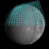
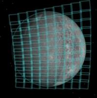
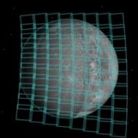
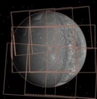
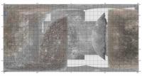
This page shows the part of Mercury that will be imaged during Flyby2.
|
|
|
|
|
Sep 30 2008, 03:40 PM
Post
#27
|
|
|
Member Group: Members Posts: 568 Joined: 20-April 05 From: Silesia Member No.: 299 |
New: Mercury Flyby 2 Instrument Operations.
http://messenger.jhuapl.edu/the_mission/mo...yby_web_sml.mov (17.8 MB) -------------------- Free software for planetary science (including Cassini Image Viewer).
http://members.tripod.com/petermasek/marinerall.html |
|
|
|
| Guest_PhilCo126_* |
Oct 2 2008, 09:25 AM
Post
#28
|
|
Guests |
That's great Peter!
The second Mercury flyby is slated for 2:40 a.m. MDT on Oct. 6 and the MESSENGER spacecraft will view areas not seen before by the 1974 & 1975 Mariner X flybys.... |
|
|
|
|
Oct 2 2008, 03:10 PM
Post
#29
|
|
|
Senior Member Group: Members Posts: 1018 Joined: 29-November 05 From: Seattle, WA, USA Member No.: 590 |
QUOTE (charborob @ Sep 29 2008, 07:49 AM) This page shows the part of Mercury that will be imaged during Flyby2. Nice! What's great about that link is that it clearly shows what was imaged by Mariner 10 and Flyby 1 and what will be imaged in this flyby. It makes it fairly clear that there will be relatively little unimaged surface after this flyby. I sent the Messenger team an e-mail about a month ago telling them I wished they'd show us something like this. They never replied, so maybe I'm vain to imagine this is a response to my request, but I was delighted to see it nonetheless! --Greg |
|
|
|
|
Oct 2 2008, 05:59 PM
Post
#30
|
|
|
Member Group: Members Posts: 706 Joined: 22-April 05 Member No.: 351 |
I hope that someone eventually publishes a map showing coverage by resolution from the flybys. It would visually show how well flybys can cover a world (useful for considering flybys of Galilean satellites, Triton, etc.).
-------------------- |
|
|
|
|
Oct 3 2008, 03:33 PM
Post
#31
|
|
|
Member Group: Members Posts: 568 Joined: 20-April 05 From: Silesia Member No.: 299 |
-------------------- Free software for planetary science (including Cassini Image Viewer).
http://members.tripod.com/petermasek/marinerall.html |
|
|
|
|
Oct 3 2008, 06:01 PM
Post
#32
|
|||
 Junior Member Group: Members Posts: 47 Joined: 27-June 08 From: Ashford, Kent, United Kingdom. Member No.: 4244 |
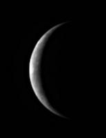
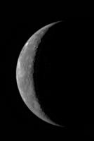
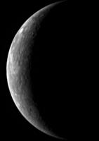
Enlargement & enhancement of Crescent Mercury.
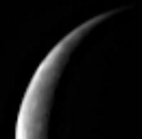
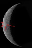
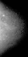
It looks like the Skinakas Basin exists after all, despite being written off, though it is still a bit too soon to jump to that conclusion. The crop & blow up I have just done shows a large feature foreshortened in the northern hemisphere. We will definitely know more tomorrow, as this afternoon's image will be approx 25% closer to Mercury than this one. There also appears to be another large impact feature in the southern hemisphere. There is clearly a smattering of much smaller craters with bright ejecta blankets in the equatorial region. Northern horn of crescent Mercury. Looks like there IS a large circular feature foreshortened. I think it is the suspected Skinakas Basin. Obviously we will know much more tomorrow as the second Navigation image will be down, from much closer in.
Every feature here is new to human eyes, very interesting & exciting. Andrew Brown. -------------------- "I suddenly noticed an anomaly to the left of Io, just off the rim of that world. It was extremely large with respect to the overall size of Io and crescent shaped. It seemed unbelievable that something that big had not been visible before". Linda Morabito on discovering that the Jupiter moon Io was volcanically active. Friday 9th March 1979.
|
||
|
|
|
||
|
Oct 3 2008, 07:57 PM
Post
#33
|
||
|
Solar System Cartographer Group: Members Posts: 10164 Joined: 5-April 05 From: Canada Member No.: 227 |
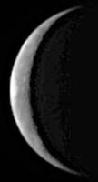
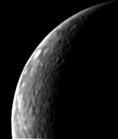
Here's another version of the new image.
Isn't Skinakas supposed to be a dark area? Nothing on here can be interpreted as a large impact basin or 'mare' from this image. I'm on record saying Skinakas doesn't exist - we will soon know. Phil
-------------------- ... because the Solar System ain't gonna map itself.
Also to be found posting similar content on https://mastodon.social/@PhilStooke Maps for download (free PD: https://upload.wikimedia.org/wikipedia/comm...Cartography.pdf NOTE: everything created by me which I post on UMSF is considered to be in the public domain (NOT CC, public domain) |
|
|
|
|
|
|
Oct 4 2008, 12:25 AM
Post
#34
|
|
|
Member Group: Members Posts: 202 Joined: 9-September 08 Member No.: 4334 |
This spacecraft is really, really exciting!
Please excuse the uninformed question, but what is Skinakas? |
|
|
|
|
Oct 4 2008, 12:46 AM
Post
#35
|
|
 Member Group: Members Posts: 524 Joined: 24-November 04 From: Heraklion, GR. Member No.: 112 |
QUOTE (Vultur @ Oct 4 2008, 03:25 AM) Please excuse the uninformed question, but what is Skinakas? Skinakas is actually a mountaintop in Crete hosting an observatory. A short story of the proposed "basin" (unfortunately named after it) is found here : http://en.wikipedia.org/wiki/Skinakas_Basin |
|
|
|
|
Oct 4 2008, 07:46 PM
Post
#36
|
||
|
Solar System Cartographer Group: Members Posts: 10164 Joined: 5-April 05 From: Canada Member No.: 227 |
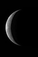
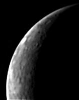
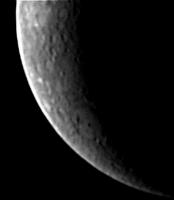
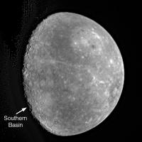
The next pic is up - here's an enlarged and processed version. A nice new basin in the south but nothing like that visible in the north.
Phil
-------------------- ... because the Solar System ain't gonna map itself.
Also to be found posting similar content on https://mastodon.social/@PhilStooke Maps for download (free PD: https://upload.wikimedia.org/wikipedia/comm...Cartography.pdf NOTE: everything created by me which I post on UMSF is considered to be in the public domain (NOT CC, public domain) |
|
|
|
|
|
|
Oct 4 2008, 10:45 PM
Post
#37
|
||
|
Solar System Cartographer Group: Members Posts: 10164 Joined: 5-April 05 From: Canada Member No.: 227 |
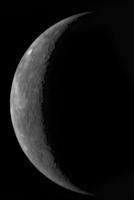
And the next...
Phil
The new southern basin's slightly lighter interior and dark spots suggest it might be a mini-Caloris. -------------------- ... because the Solar System ain't gonna map itself.
Also to be found posting similar content on https://mastodon.social/@PhilStooke Maps for download (free PD: https://upload.wikimedia.org/wikipedia/comm...Cartography.pdf NOTE: everything created by me which I post on UMSF is considered to be in the public domain (NOT CC, public domain) |
|
|
|
|
|
|
Oct 4 2008, 11:49 PM
Post
#38
|
|||
|
Junior Member Group: Members Posts: 47 Joined: 27-June 08 From: Ashford, Kent, United Kingdom. Member No.: 4244 |
Hi Phil,
Certainly Skinakas Does Not exist. I really hope that the fifth image will be available soon. That southern basin is impressive. Certainly is reminicent of a mini Caloris. I've had a go at enlargening & sharpening each hemisphere from the original. Northern Hemisphere enlarged.
Southern Hemisphere enlarged.
Andrew Brown. -------------------- "I suddenly noticed an anomaly to the left of Io, just off the rim of that world. It was extremely large with respect to the overall size of Io and crescent shaped. It seemed unbelievable that something that big had not been visible before". Linda Morabito on discovering that the Jupiter moon Io was volcanically active. Friday 9th March 1979.
|
||
|
|
|
||
|
Oct 5 2008, 02:44 AM
Post
#39
|
|
|
Administrator Group: Admin Posts: 5172 Joined: 4-August 05 From: Pasadena, CA, USA, Earth Member No.: 454 |
QUOTE (Phil Stooke @ Oct 4 2008, 03:45 PM) The new southern basin's slightly lighter interior and dark spots suggest it might be a mini-Caloris. Yeah, looks a lot like Tolstoj (that dark-rimmed bright-centered thing in the southern hemisphere on the limb in the flyby 1 departure images). --Emily -------------------- My website - My Patreon - @elakdawalla on Twitter - Please support unmannedspaceflight.com by donating here.
|
|
|
|
|
Oct 5 2008, 03:38 AM
Post
#40
|
|
 Senior Member Group: Moderator Posts: 3233 Joined: 11-February 04 From: Tucson, AZ Member No.: 23 |
That's the one I was trying to think of. Thanks, Emily. Nice central peak on that basin too.
-------------------- &@^^!% Jim! I'm a geologist, not a physicist!
The Gish Bar Times - A Blog all about Jupiter's Moon Io |
|
|
|
|
Oct 5 2008, 09:38 AM
Post
#41
|
||
|
Junior Member Group: Members Posts: 73 Joined: 25-June 07 From: United States Member No.: 2537 |
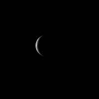
Getting closer.
|
|
|
|
|
|
|
Oct 5 2008, 10:29 AM
Post
#42
|
||||
|
Junior Member Group: Members Posts: 47 Joined: 27-June 08 From: Ashford, Kent, United Kingdom. Member No.: 4244 |
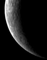
Image # 5.
#5 Image Northern Hemisphere.
#5 Image Southern Hemisphere.
That basin is really coming into its own now. More dark spots are starting to appear on it's floor. Andrew Brown. -------------------- "I suddenly noticed an anomaly to the left of Io, just off the rim of that world. It was extremely large with respect to the overall size of Io and crescent shaped. It seemed unbelievable that something that big had not been visible before". Linda Morabito on discovering that the Jupiter moon Io was volcanically active. Friday 9th March 1979.
|
|||
|
|
|
|||
|
Oct 5 2008, 11:20 AM
Post
#43
|
|
|
Member Group: Members Posts: 401 Joined: 5-January 07 From: Manchester England Member No.: 1563 |
To me it looks less like a basin with dark spots, more like a basin with a mottled floor. Thats a bit pedentic I know but I wonder if there's a partial covering of dark lava flows on the basin (mottled) or if later impacts have excavated darker material (spots).
-------------------- |
|
|
|
|
Oct 5 2008, 12:57 PM
Post
#44
|
||
|
Solar System Cartographer Group: Members Posts: 10164 Joined: 5-April 05 From: Canada Member No.: 227 |
Caloris suggests an answer to your question!
Here's the last image in my style of processing. Phil
-------------------- ... because the Solar System ain't gonna map itself.
Also to be found posting similar content on https://mastodon.social/@PhilStooke Maps for download (free PD: https://upload.wikimedia.org/wikipedia/comm...Cartography.pdf NOTE: everything created by me which I post on UMSF is considered to be in the public domain (NOT CC, public domain) |
|
|
|
|
|
|
Oct 5 2008, 02:55 PM
Post
#45
|
||
|
Solar System Cartographer Group: Members Posts: 10164 Joined: 5-April 05 From: Canada Member No.: 227 |
The feature highlighted here may be another old impact basin, overlapped on the north side by a later double-ring basin.
Phil
-------------------- ... because the Solar System ain't gonna map itself.
Also to be found posting similar content on https://mastodon.social/@PhilStooke Maps for download (free PD: https://upload.wikimedia.org/wikipedia/comm...Cartography.pdf NOTE: everything created by me which I post on UMSF is considered to be in the public domain (NOT CC, public domain) |
|
|
|
|
|
|
Oct 5 2008, 05:03 PM
Post
#46
|
||
|
Member Group: Members Posts: 311 Joined: 31-August 05 From: Florida & Texas, USA Member No.: 482 |
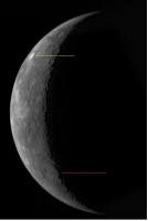
Hoping someone can clue me in on what we're seeing: Why is the crater pointed to with the green line so bright? Solar glare or is it surface composition? Is the feature pointed to with the red line perhaps volcanic? |
|
|
|
|
|
|
Oct 5 2008, 05:56 PM
Post
#47
|
|
 Senior Member Group: Moderator Posts: 2785 Joined: 10-November 06 From: Pasadena, CA Member No.: 1345 |
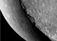
The shading on the southern basin towards the terminator looks "not right" (shouldn't it be bright rather than shaded?). Or is that a processing artifact?
-Mike -------------------- Some higher resolution images available at my photostream: http://www.flickr.com/photos/31678681@N07/
|
|
|
|
|
Oct 5 2008, 06:01 PM
Post
#48
|
|
|
Rover Driver Group: Members Posts: 1015 Joined: 4-March 04 Member No.: 47 |
i agree. it looks more like the edge of olympus mons like this.
all the other craters seem to have the shadow on the 'right' side. |
|
|
|
|
Oct 5 2008, 06:41 PM
Post
#49
|
||
 Senior Member Group: Members Posts: 3419 Joined: 9-February 04 From: Minneapolis, MN, USA Member No.: 15 |
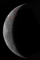
Hmmm... no Skinakas? I see arc-shaped lobes of dark material, in some areas bounded by what appear to be old, degraded arcs of rimwall massif. I'm not a consummate image manipulator, but look within the crudely drawn red circle below:
I really do see a structure there that seems to be roughly concentric with that very roughly drawn red circle. Very degraded, yes -- the southern rim seems to have been obliterated by subsequent large craters. But this might be a basin, after all... -the other Doug -------------------- The trouble ain't that there is too many fools, but that the lightning ain't distributed right. -Mark Twain
|
|
|
|
|
|
|
Oct 5 2008, 06:43 PM
Post
#50
|
|
|
Senior Member Group: Moderator Posts: 3233 Joined: 11-February 04 From: Tucson, AZ Member No.: 23 |
Looks like a good sized impact basin to me. Though it seems to be a central pit basin, rather than a central peak basin
 Doug, that looks like an optical illusion to me. I saw what you were talking about earlier, but now I really just see a chance alignment of craters. -------------------- &@^^!% Jim! I'm a geologist, not a physicist!
The Gish Bar Times - A Blog all about Jupiter's Moon Io |
|
|
|
|
Oct 5 2008, 06:50 PM
Post
#51
|
|
|
Solar System Cartographer Group: Members Posts: 10164 Joined: 5-April 05 From: Canada Member No.: 227 |
The odd shading in the southern basin is most easily explained as one of those big lobate scarps crossing the floor, or possibly part of a multi-ring structure. That bright spot alluded to earlier - a fresh impact crater or one of those craters we saw in the first encounter with extremely bright deposits on the floor. The past (encounter 1) is the key to the present, at least to generate a first hypothesis.
As for 'skinakas' - the feature described from earth was a lot bigger than the darker spots outlined above. If there's a basin rim up there I can't see it. Phil -------------------- ... because the Solar System ain't gonna map itself.
Also to be found posting similar content on https://mastodon.social/@PhilStooke Maps for download (free PD: https://upload.wikimedia.org/wikipedia/comm...Cartography.pdf NOTE: everything created by me which I post on UMSF is considered to be in the public domain (NOT CC, public domain) |
|
|
|
|
Oct 5 2008, 06:51 PM
Post
#52
|
|
|
Senior Member Group: Members Posts: 3419 Joined: 9-February 04 From: Minneapolis, MN, USA Member No.: 15 |
I almost decided it was a chance alignment of craters, too -- but my eye keeps going back to the dark-albedo arcs to the north and south. Those seem to be independent of the craters in the area, and their arc shapes define a big circular feature. Now, it seems to me that a big circular feature like that would have to be either the degraded remnants of a huge shield volcano or the degraded remnants of a basin. Since we've seen a lot of the latter and no other indications of the former, I sort of get led down the garden path to Skinakas...
-the other Doug -------------------- The trouble ain't that there is too many fools, but that the lightning ain't distributed right. -Mark Twain
|
|
|
|
|
Oct 5 2008, 07:24 PM
Post
#53
|
|
|
Member Group: Members Posts: 293 Joined: 22-September 08 From: Spain Member No.: 4350 |
It will be interesting to see if there are volcanoes at the opposite side of Caloris Basin. So far the southern side looks less cratered.
|
|
|
|
|
Oct 5 2008, 08:14 PM
Post
#54
|
|
|
Member Group: Members Posts: 540 Joined: 17-November 05 From: Oklahoma Member No.: 557 |
QUOTE (dvandorn @ Oct 5 2008, 01:51 PM) I almost decided it was a chance alignment of craters, too -- but my eye keeps going back to the dark-albedo arcs to the north and south. I know what you mean. I can't get over the feeling that there is something there. At the very least, we may be seeing the chance illusion that led to Skinakas in the first place. This may be one of those cases where more detail isn't going to help, and the coarse resolution pictures may show it best, provided there is an "it". If there is an old basin there, it may take laser altimetry from orbit to settle the issue. Well, I may regret this, but I'm going to vote that there is something to Skinakas. |
|
|
|
|
Oct 6 2008, 12:04 AM
Post
#55
|
|
|
Member Group: Members Posts: 509 Joined: 2-July 05 From: Calgary, Alberta Member No.: 426 |
QUOTE (Holder of the Two Leashes @ Oct 5 2008, 02:14 PM) At the very least, we may be seeing the chance illusion that led to Skinakas in the first place. This one had occurred to me as well. Maybe that's what we ought to concentrate on trying to sort out. I wonder if the illusion (if that's what it is) could be reproduced by taking some of tomorrow's images, and running them through a low pass filter to fuzz them out a bit? |
|
|
|
|
Oct 6 2008, 12:22 AM
Post
#56
|
|
|
Solar System Cartographer Group: Members Posts: 10164 Joined: 5-April 05 From: Canada Member No.: 227 |
My opinion is that Skinakas is nothing more than a region relatively free of ray craters, appearing a bit darker than its surroundings. You have to look at the original paper to see how tenuous the basin interpretation was. That sort of study can be done with these early images, there's no need to wait.
Check it out here - figure 9 is the image. http://www.alpo-astronomy.org/mercury/Ksanfomality.pdf Phil -------------------- ... because the Solar System ain't gonna map itself.
Also to be found posting similar content on https://mastodon.social/@PhilStooke Maps for download (free PD: https://upload.wikimedia.org/wikipedia/comm...Cartography.pdf NOTE: everything created by me which I post on UMSF is considered to be in the public domain (NOT CC, public domain) |
|
|
|
|
Oct 6 2008, 12:24 AM
Post
#57
|
|
|
Member Group: Members Posts: 340 Joined: 11-April 08 From: Sydney, Australia Member No.: 4093 |
Just over 8 hrs to closest approach, Messenger is now inside Mercury's hill-sphere. First wave of systems flyby mode activation is now just 2 hours away. Mercury is now "growing" noticeably as seen from Messenger ... JPL's solar system simulator seems to be holding up at present, so you can still watch the auto-refreshed images and timeline ticking by on my timeline simulator at http://www.dmuller.net/messenger
-------------------- |
|
|
|
|
Oct 6 2008, 12:49 AM
Post
#58
|
|
 Senior Member Group: Members Posts: 1431 Joined: 26-July 08 Member No.: 4270 |
A new picture appeared.
http://messenger.jhuapl.edu/gallery/scienc...0131695690M.jpg -------------------- -- Hungry4info (Sirius_Alpha)
|
|
|
|
|
Oct 6 2008, 12:59 AM
Post
#59
|
|
|
Senior Member Group: Moderator Posts: 3233 Joined: 11-February 04 From: Tucson, AZ Member No.: 23 |
Very nice. Now high enough res to actually do some analysis, not just make guess as to what we are seeing (even if it is a lot of fun
 The southern hemisphere basin looks like a double-ring basin with a dark-halo crater near the center of it. The very bright spot in the northern hemisphere looks like a small ray crater, but very fresh with a lot bright material surrounding it. I see no evidence to support a large, northern hemisphere basin -------------------- &@^^!% Jim! I'm a geologist, not a physicist!
The Gish Bar Times - A Blog all about Jupiter's Moon Io |
|
|
|
|
Oct 6 2008, 01:15 AM
Post
#60
|
||
|
Senior Member Group: Moderator Posts: 2785 Joined: 10-November 06 From: Pasadena, CA Member No.: 1345 |
Arrgh. VP beat me to it!
Anyway here's my contrast enhanced view of the southern multi-ring basin, and two other smaller multi-ring craters up at the top of the image. The bright reflection of the outer ring of the southern ring basin is visible (and bright like you'd expect).
(And I'm gonna assume that's a hot pixel or cosmic ray hit just off Mercury's limb) -Mike [EDIT: The edge of the southern basin at the terminator is gonna look really dramatic as we get closer!] -------------------- Some higher resolution images available at my photostream: http://www.flickr.com/photos/31678681@N07/
|
|
|
|
|
|
|
Oct 6 2008, 01:22 PM
Post
#61
|
||
 Lord Of The Uranian Rings Group: Members Posts: 798 Joined: 18-July 05 From: Plymouth, UK Member No.: 437 |
Here's a rough attempt at generating an overhead view:
-------------------- |
|
|
|
|
|
|
Oct 6 2008, 02:15 PM
Post
#62
|
|
|
Junior Member Group: Members Posts: 55 Joined: 8-November 06 From: Indiana, USA Member No.: 1337 |
Close Approach has passed. Is there any news about the spacecraft's performance during this critical stage?
|
|
|
|
|
Oct 6 2008, 02:15 PM
Post
#63
|
|
|
Founder Group: Chairman Posts: 14432 Joined: 8-February 04 Member No.: 1 |
The spacecraft doesn't start downlinking for several hours yet.
|
|
|
|
|
Oct 6 2008, 03:57 PM
Post
#64
|
|
|
Junior Member Group: Members Posts: 55 Joined: 8-November 06 From: Indiana, USA Member No.: 1337 |
Thanks.
I just figured the spacecraft would be monitored throughout the encounter, and we would have word by now that the spacecraft didn't safe or something similar. |
|
|
|
|
Oct 6 2008, 06:14 PM
Post
#65
|
|
|
Senior Member Group: Members Posts: 1018 Joined: 29-November 05 From: Seattle, WA, USA Member No.: 590 |
They have an update
http://messenger.jhuapl.edu/news_room/details.php?id=110 Here's a relevant bit from it: At a little after 4:40 a.m. EDT, MESSENGER skimmed 200 kilometers (124 miles) above the surface of Mercury . . . Initial indications from the radio signals indicate that the spacecraft continues to operate nominally. The first pictures from the flyby will be released around 10:00 a.m. on October 7, 2008. --Greg |
|
|
|
|
Oct 6 2008, 07:11 PM
Post
#66
|
|
 Member Group: Members Posts: 646 Joined: 23-December 05 From: Forest of Dean Member No.: 617 |
QUOTE (Greg Hullender) The first pictures from the flyby will be released around 10:00 a.m. on October 7, 2008. Gak! You know you're living online too long when... your brain automatically labels time values without a TZ as non-conformant  All the other times in the update are given in EST, so presumably that's 1500 UTC / 4pm BST. -------------------- --
Viva software libre! |
|
|
|
|
Oct 6 2008, 07:59 PM
Post
#67
|
||
|
Solar System Cartographer Group: Members Posts: 10164 Joined: 5-April 05 From: Canada Member No.: 227 |
This is a rough fit of the inbound coverage to Steve's map, to give an idea of the locations of features. I took IanR's image (above) and projected it to make the terminator a straight line, then overlaid it on Steve's map and fiddled with the scales until there was a reasonable match between features in the radar images and these new navigation images. There are about 10 or 12 matches between radar and messenger, so I think it's roughly correct. I emphasize roughly though, as the distortions to fit this to the map are very ad hoc.
Phil
-------------------- ... because the Solar System ain't gonna map itself.
Also to be found posting similar content on https://mastodon.social/@PhilStooke Maps for download (free PD: https://upload.wikimedia.org/wikipedia/comm...Cartography.pdf NOTE: everything created by me which I post on UMSF is considered to be in the public domain (NOT CC, public domain) |
|
|
|
|
|
|
Oct 6 2008, 08:12 PM
Post
#68
|
||
|
Solar System Cartographer Group: Members Posts: 10164 Joined: 5-April 05 From: Canada Member No.: 227 |
... and here is the last image from the first encounter, processed to emphasize detail on the terminator. The big bite out of the terminator is the other bit of the rim of the 'new' southern basin.
Phil
-------------------- ... because the Solar System ain't gonna map itself.
Also to be found posting similar content on https://mastodon.social/@PhilStooke Maps for download (free PD: https://upload.wikimedia.org/wikipedia/comm...Cartography.pdf NOTE: everything created by me which I post on UMSF is considered to be in the public domain (NOT CC, public domain) |
|
|
|
|
|
|
Oct 6 2008, 10:09 PM
Post
#69
|
||
|
Senior Member Group: Moderator Posts: 2785 Joined: 10-November 06 From: Pasadena, CA Member No.: 1345 |
Combination of Phil Stooke's image and my image of the Southern Basin:
(Dunno how accurate it is, but it was fun to try!) -Mike -------------------- Some higher resolution images available at my photostream: http://www.flickr.com/photos/31678681@N07/
|
|
|
|
|
|
|
Oct 7 2008, 06:52 AM
Post
#70
|
||
 Senior Member Group: Admin Posts: 3108 Joined: 21-December 05 From: Canberra, Australia Member No.: 615 |
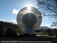
Just waiting for the latest images from Messenger to come in, so I thought I'd step outside my office and take a look at the 70-metre dish performing the downlink. Here's a nice view of Deep Space Station 43 currently bringing down the high priority data which should include the full-disk inbound and outbound images from yesterday's flyby.
Astro0 |
|
|
|
|
|
|
Oct 7 2008, 07:07 AM
Post
#71
|
|
|
Member Group: Members Posts: 340 Joined: 11-April 08 From: Sydney, Australia Member No.: 4093 |
hey Astro0 ... there's no USB plug on that thing with a cable straight to your PC?
BTW sent you updated script just now -------------------- |
|
|
|
|
Oct 7 2008, 11:59 AM
Post
#72
|
||
|
Junior Member Group: Members Posts: 73 Joined: 25-June 07 From: United States Member No.: 2537 |
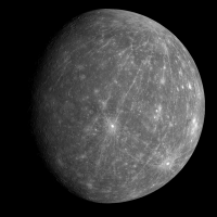
New image of Mercury.
|
|
|
|
|
|
|
Oct 7 2008, 12:17 PM
Post
#73
|
||
 Interplanetary Dumpster Diver Group: Admin Posts: 4404 Joined: 17-February 04 From: Powell, TN Member No.: 33 |
That is amazing! It has the feel of this Mariner-10 image.
Attached thumbnail(s)
-------------------- |
|
|
|
|
|
|
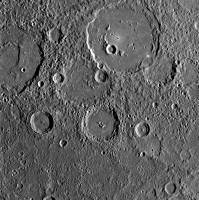
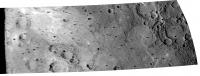
Oct 7 2008, 12:18 PM
Post
#74
|
|
|
Rover Driver Group: Members Posts: 1015 Joined: 4-March 04 Member No.: 47 |
|
|
|
|
|
Oct 7 2008, 12:40 PM
Post
#75
|
||
|
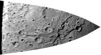
Junior Member Group: Members Posts: 47 Joined: 27-June 08 From: Ashford, Kent, United Kingdom. Member No.: 4244 |
It is indeed.!!!!!!
I've had a go at cropping off & enlargening the previously unseen terrain towards the hermean limb.
Andrew Brown. -------------------- "I suddenly noticed an anomaly to the left of Io, just off the rim of that world. It was extremely large with respect to the overall size of Io and crescent shaped. It seemed unbelievable that something that big had not been visible before". Linda Morabito on discovering that the Jupiter moon Io was volcanically active. Friday 9th March 1979.
|
|
|
|
|
|
|
Oct 7 2008, 12:41 PM
Post
#76
|
|
 Senior Member Group: Members Posts: 3648 Joined: 1-October 05 From: Croatia Member No.: 523 |
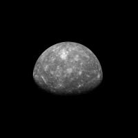
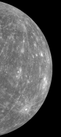
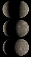
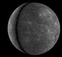
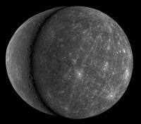
A collage of 4 views of Mercury provided by MESSENGER:
The top two shots are January flyby WAC shots in calibrated RGB color (contrast-stretched as noted in previous threads), below are the two highest resolution shots yet released in pseudo-color based on top composites.  EDIT: Updated the inbound crescent with a higher resolution WAC shot just released. -------------------- |
|
|
|
|
Oct 7 2008, 01:47 PM
Post
#77
|
|
 Member Group: Members Posts: 160 Joined: 4-July 05 From: Huntington Beach, CA, USA Member No.: 429 |
Can we say that Skinakas doesn't exist? I don't see any basin.
|
|
|
|
|
Oct 7 2008, 02:03 PM
Post
#78
|
||
|
Newbie Group: Members Posts: 6 Joined: 11-April 07 From: California Member No.: 1961 |
QUOTE (dvandorn @ Oct 5 2008, 10:41 AM) Hmmm... no Skinakas? I see arc-shaped lobes of dark material, in some areas bounded by what appear to be old, degraded arcs of rimwall massif. I'm not a consummate image manipulator, but look within the crudely drawn red circle below:
I really do see a structure there that seems to be roughly concentric with that very roughly drawn red circle. Very degraded, yes -- the southern rim seems to have been obliterated by subsequent large craters. But this might be a basin, after all... -the other Doug From the longitude and latitude, the Skinakas Basin would've been the dark albedo circle just below yours. |
|
|
|
|
|
|
Oct 7 2008, 02:09 PM
Post
#79
|
|
|
Senior Member Group: Members Posts: 3648 Joined: 1-October 05 From: Croatia Member No.: 523 |
http://messenger.jhuapl.edu/gallery/scienc...mp;image_id=215
http://messenger.jhuapl.edu/gallery/scienc...mp;image_id=217 -------------------- |
|
|
|
|
Oct 7 2008, 02:15 PM
Post
#80
|
|
|
Solar System Cartographer Group: Members Posts: 10164 Joined: 5-April 05 From: Canada Member No.: 227 |
Skinakas was a ray-free area of cratered terrain, not a basin. I think a good analogy here is with the old Soviet Mountains in Luna 3 images - low resolution albedo interpreted as topography, which is unwarranted. See the link to the original Skinakas paper in post #56 above.
Phil -------------------- ... because the Solar System ain't gonna map itself.
Also to be found posting similar content on https://mastodon.social/@PhilStooke Maps for download (free PD: https://upload.wikimedia.org/wikipedia/comm...Cartography.pdf NOTE: everything created by me which I post on UMSF is considered to be in the public domain (NOT CC, public domain) |
|
|
|
|
Oct 7 2008, 02:16 PM
Post
#81
|
||
|
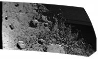
Member Group: Members Posts: 212 Joined: 19-July 05 Member No.: 442 |
It looks like Tycho's all over...
The first close-ups are also in, I can't wait to see the pictures of the Caloris Antipoidal point. http://messenger.jhuapl.edu/gallery/scienc...mp;image_id=215
Attached thumbnail(s)
|
|
|
|
|
|
|
Oct 7 2008, 02:22 PM
Post
#82
|
|
|
Member Group: Members Posts: 212 Joined: 19-July 05 Member No.: 442 |
The level of detail in pic 217 looks eerily like a model of the lunar surface.
|
|
|
|
|
Oct 7 2008, 02:27 PM
Post
#83
|
||
|
Solar System Cartographer Group: Members Posts: 10164 Joined: 5-April 05 From: Canada Member No.: 227 |
Here's the oblique view reprojected.
Phil
-------------------- ... because the Solar System ain't gonna map itself.
Also to be found posting similar content on https://mastodon.social/@PhilStooke Maps for download (free PD: https://upload.wikimedia.org/wikipedia/comm...Cartography.pdf NOTE: everything created by me which I post on UMSF is considered to be in the public domain (NOT CC, public domain) |
|
|
|
|
|
|
Oct 7 2008, 02:31 PM
Post
#84
|
|
|
Senior Member Group: Moderator Posts: 2785 Joined: 10-November 06 From: Pasadena, CA Member No.: 1345 |
QUOTE (Phil Stooke @ Oct 7 2008, 10:27 AM) Here's the oblique view reprojected. So the feature on the right is the NW corner of what we've been calling the "southern basin" then? -Mike -------------------- Some higher resolution images available at my photostream: http://www.flickr.com/photos/31678681@N07/
|
|
|
|
|
Oct 7 2008, 07:23 PM
Post
#85
|
||
|
Interplanetary Dumpster Diver Group: Admin Posts: 4404 Joined: 17-February 04 From: Powell, TN Member No.: 33 |
Here is Ugordan's montage with the Mariner 10 mosaics added.
Ted
-------------------- |
|
|
|
|
|
|
Oct 7 2008, 07:58 PM
Post
#86
|
|
|
Senior Member Group: Members Posts: 3648 Joined: 1-October 05 From: Croatia Member No.: 523 |
Awesome, Ted!
-------------------- |
|
|
|
|
Oct 7 2008, 08:02 PM
Post
#87
|
|
|
Interplanetary Dumpster Diver Group: Admin Posts: 4404 Joined: 17-February 04 From: Powell, TN Member No.: 33 |
QUOTE (ugordan @ Oct 7 2008, 07:58 PM) Awesome, Ted! Thanks. I will say that the color is a bit wacky. I tried to tweak the images to match Messenger color. Since the filters don't come anywhere near matching, there were limits to how well this could be done. It is interesting how that one new ray crater dominates so much of the planet. -------------------- |
|
|
|
|
Oct 8 2008, 03:20 PM
Post
#88
|
|
|
Member Group: Members Posts: 568 Joined: 20-April 05 From: Silesia Member No.: 299 |
Next image set:
http://messenger.jhuapl.edu/gallery/scienc...hp?gallery_id=2 -------------------- Free software for planetary science (including Cassini Image Viewer).
http://members.tripod.com/petermasek/marinerall.html |
|
|
|
|
Oct 8 2008, 03:35 PM
Post
#89
|
|
|
Senior Member Group: Moderator Posts: 2785 Joined: 10-November 06 From: Pasadena, CA Member No.: 1345 |
From caption for this image:
QUOTE "The crater in the upper right corner of this image is Boethius, which can also be seen in the WAC image released yesterday. These images overlap and will be used to produce the highest-resolution color mosaic ever obtained of Mercurys surface." [I can hear the UMSF processor chips revving up now....] -------------------- Some higher resolution images available at my photostream: http://www.flickr.com/photos/31678681@N07/
|
|
|
|
|
Oct 8 2008, 03:50 PM
Post
#90
|
||
|
Founder Group: Chairman Posts: 14432 Joined: 8-February 04 Member No.: 1 |
Was the processing loud?
Attached thumbnail(s)
|
|
|
|
|
|
|
Oct 8 2008, 03:58 PM
Post
#91
|
||
|
Administrator Group: Admin Posts: 5172 Joined: 4-August 05 From: Pasadena, CA, USA, Earth Member No.: 454 |
Here's an updated version of my context map. The new WAC image doesn't quite overlap with the NAC from yesterday, but there is nice overlap with the WAC.
The large crater in the center of the mosaic is Boethius; the large one to the upper right is Polygnotus. --Emily -------------------- My website - My Patreon - @elakdawalla on Twitter - Please support unmannedspaceflight.com by donating here.
|
|
|
|
|
|
|
Oct 8 2008, 04:41 PM
Post
#92
|
|
|
Senior Member Group: Members Posts: 1018 Joined: 29-November 05 From: Seattle, WA, USA Member No.: 590 |
In the "are we there yet" spirit, given that this flyby dropped the period of Messenger's orbit from 132 days to 116 days, Flyby #3 (almost a year away) will happen in just a bit more than three orbits. Remembering that the original orbit had exactly a one-year period, we sure have come a long way!
--Greg |
|
|
|
|
Oct 8 2008, 04:47 PM
Post
#93
|
||
|
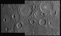
Solar System Cartographer Group: Members Posts: 10164 Joined: 5-April 05 From: Canada Member No.: 227 |
Here's a reprojection of the smooth plains image. If this isn't a case of volcanic plains embaying the cratered terrain I'm a monkey's uncle.
Phil
-------------------- ... because the Solar System ain't gonna map itself.
Also to be found posting similar content on https://mastodon.social/@PhilStooke Maps for download (free PD: https://upload.wikimedia.org/wikipedia/comm...Cartography.pdf NOTE: everything created by me which I post on UMSF is considered to be in the public domain (NOT CC, public domain) |
|
|
|
|
|
|
Oct 8 2008, 05:01 PM
Post
#94
|
||
|
Solar System Cartographer Group: Members Posts: 10164 Joined: 5-April 05 From: Canada Member No.: 227 |
... and another one of the northern limb. This kind of reprojection makes the limb images much easier to interpret.
Phil
-------------------- ... because the Solar System ain't gonna map itself.
Also to be found posting similar content on https://mastodon.social/@PhilStooke Maps for download (free PD: https://upload.wikimedia.org/wikipedia/comm...Cartography.pdf NOTE: everything created by me which I post on UMSF is considered to be in the public domain (NOT CC, public domain) |
|
|
|
|
|
|
Oct 8 2008, 05:09 PM
Post
#95
|
|
|
Senior Member Group: Moderator Posts: 2785 Joined: 10-November 06 From: Pasadena, CA Member No.: 1345 |
Is it just me or does almost every other "fresher" crater in Doug's combined image here seem to have a scarp bisecting the crater?
-Mike -------------------- Some higher resolution images available at my photostream: http://www.flickr.com/photos/31678681@N07/
|
|
|
|
|
Oct 8 2008, 07:28 PM
Post
#96
|
|
|
Lord Of The Uranian Rings Group: Members Posts: 798 Joined: 18-July 05 From: Plymouth, UK Member No.: 437 |
QUOTE (Phil Stooke @ Oct 8 2008, 05:47 PM) Here's a reprojection of the smooth plains image. If this isn't a case of volcanic plains embaying the cratered terrain I'm a monkey's uncle. Wow - are those wrinkle ridges in that picture Phil? If so, does this indicate that this volcanic flow was more viscous than those we typically see on the Moon? -------------------- |
|
|
|
|
Oct 8 2008, 08:04 PM
Post
#97
|
|
 The Poet Dude Group: Moderator Posts: 5551 Joined: 15-March 04 From: Kendal, Cumbria, UK Member No.: 60 |
Mercury's starting to look a lot like one of Chesley Bonestell's Moon paintings...
-------------------- |
|
|
|
|
Oct 8 2008, 10:41 PM
Post
#98
|
|
|
Merciless Robot Group: Admin Posts: 8784 Joined: 8-December 05 From: Los Angeles Member No.: 602 |
QUOTE (Juramike @ Oct 8 2008, 09:09 AM) Is it just me or does almost every other "fresher" crater in Doug's combined image here seem to have a scarp bisecting the crater? -Mike I don't think you're wrong. Hmm. Makes you kind of wonder if the crust of Mercury may have extensive deep magma reservoirs above the Hermian equivalent of the Mohorovicic Discontinuity; too deep to produce vulcanism, but enough to cause slumping & shifting after a major impact. -------------------- A few will take this knowledge and use this power of a dream realized as a force for change, an impetus for further discovery to make less ancient dreams real.
|
|
|
|
|
Oct 9 2008, 04:48 AM
Post
#99
|
|
|
Senior Member Group: Members Posts: 1018 Joined: 29-November 05 From: Seattle, WA, USA Member No.: 590 |
QUOTE (Juramike @ Oct 8 2008, 09:09 AM) Is it just me or does almost every other "fresher" crater in Doug's combined image here seem to have a scarp bisecting the crater? Well, we haven't actually seen a picture of you, so it's hard to be sure. --Greg :-) |
|
|
|
|
Oct 9 2008, 12:43 PM
Post
#100
|
|||
|
Solar System Cartographer Group: Members Posts: 10164 Joined: 5-April 05 From: Canada Member No.: 227 |
The Vivaldi release - showing that the same crater can be seen in both encounters with opposite lighting - and Juramike's post showing the big southern basin in a composite of two views - suggest that you can combine the views from these two encounters. It's possible but not perfect. Here is one hemisphere:
It works very well. Several craters along the terminator are visible in both views, and the combination of views looks roughly globe-like. The other side doesn't work so well:
It's not as symmetric as you might think. But it does give the idea. A proper Steve Albers-style reprojection would allow it to work properly. I'm only playing with Photoshop here. Phil -------------------- ... because the Solar System ain't gonna map itself.
Also to be found posting similar content on https://mastodon.social/@PhilStooke Maps for download (free PD: https://upload.wikimedia.org/wikipedia/comm...Cartography.pdf NOTE: everything created by me which I post on UMSF is considered to be in the public domain (NOT CC, public domain) |
||
|
|
|
||
|

|
Lo-Fi Version | Time is now: 22nd May 2024 - 02:27 PM |
|
RULES AND GUIDELINES Please read the Forum Rules and Guidelines before posting. IMAGE COPYRIGHT |
OPINIONS AND MODERATION Opinions expressed on UnmannedSpaceflight.com are those of the individual posters and do not necessarily reflect the opinions of UnmannedSpaceflight.com or The Planetary Society. The all-volunteer UnmannedSpaceflight.com moderation team is wholly independent of The Planetary Society. The Planetary Society has no influence over decisions made by the UnmannedSpaceflight.com moderators. |
SUPPORT THE FORUM Unmannedspaceflight.com is funded by the Planetary Society. Please consider supporting our work and many other projects by donating to the Society or becoming a member. |
|