South to Vera Rubin Ridge, (Sites 62-63, Sols 1659-1726, Apr 6 2017-Jun 14 2017) |

  |
South to Vera Rubin Ridge, (Sites 62-63, Sols 1659-1726, Apr 6 2017-Jun 14 2017) |
 May 9 2017, 06:29 PM May 9 2017, 06:29 PM
Post
#91
|
|||
|
Solar System Cartographer  Group: Members Posts: 10153 Joined: 5-April 05 From: Canada Member No.: 227 |
Sol 1691 - a short drive, just a few metres, southwestish. Here are the reprojected Hazcams and my recent circular image showing the drive very roughly - map update tonight.
Phil
-------------------- ... because the Solar System ain't gonna map itself.
Also to be found posting similar content on https://mastodon.social/@PhilStooke Maps for download (free PD: https://upload.wikimedia.org/wikipedia/comm...Cartography.pdf NOTE: everything created by me which I post on UMSF is considered to be in the public domain (NOT CC, public domain) |
||
 |
 
|
||
|
May 9 2017, 08:34 PM
Post
#92
|
||||
|
Member Group: Members Posts: 866 Joined: 15-March 05 From: Santa Cruz, CA Member No.: 196 |
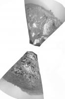
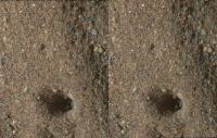
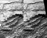
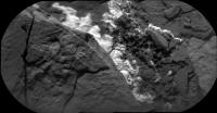
layer flake stereo of sol1688, presumably one of the '_Brook' vein targets. I'm not sure what the story is with that 'hole' apparently punched in the distressed area with Mahli pin chevrons apparently dragged behind.. the visible Z-offset stripes perhaps due to scan differences in the images being overlaid and made apparent in the stereo, the Mahli frame maybe crept a bit during exposure due to MSL settling?
|
|||
|
|
|
|||
|
May 9 2017, 10:10 PM
Post
#93
|
|
 Senior Member Group: Members Posts: 4246 Joined: 17-January 05 Member No.: 152 |
QUOTE (atomoid @ May 9 2017, 09:34 PM)  the visible Z-offset stripes perhaps due to scan differences in the images being overlaid and made apparent in the stereo, the Mahli frame maybe crept a bit during exposure due to MSL settling? If those are focus stacks, that's the kind of thing you expect since the process combines parts of the various images with the best focus. The original images shouldn't show those effects. |
|
|
|
|
May 9 2017, 10:45 PM
Post
#94
|
|
|
Solar System Cartographer Group: Members Posts: 10153 Joined: 5-April 05 From: Canada Member No.: 227 |
"I'm not sure what the story is with that 'hole' apparently punched in the distressed area with Mahli pin chevrons apparently dragged behind.. "
That's no MAHLI pin chevron! Those are ChemCam pits in sand, made the day before: http://www.midnightplanets.com/web/MSL/ima...CAM02687L1.html Each new blast pushes sand into the previous pit (each pit is the sum of numerous zaps with the laser). Phil -------------------- ... because the Solar System ain't gonna map itself.
Also to be found posting similar content on https://mastodon.social/@PhilStooke Maps for download (free PD: https://upload.wikimedia.org/wikipedia/comm...Cartography.pdf NOTE: everything created by me which I post on UMSF is considered to be in the public domain (NOT CC, public domain) |
|
|
|
|
May 10 2017, 03:08 AM
Post
#95
|
||
|
Solar System Cartographer Group: Members Posts: 10153 Joined: 5-April 05 From: Canada Member No.: 227 |
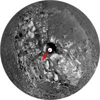
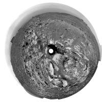
This is Jan's panorama from sol 1690 in circular form. It's basically the same as Paul's except I took it out to the horizon. We get a good view of the geography of the site. The Murray Buttes are just becoming visible again - they had disappeared behind the local horizon for a while but as we climb they are reappearing.
Phil
-------------------- ... because the Solar System ain't gonna map itself.
Also to be found posting similar content on https://mastodon.social/@PhilStooke Maps for download (free PD: https://upload.wikimedia.org/wikipedia/comm...Cartography.pdf NOTE: everything created by me which I post on UMSF is considered to be in the public domain (NOT CC, public domain) |
|
|
|
|
|
|
May 10 2017, 11:30 AM
Post
#96
|
||
|
Senior Member Group: Members Posts: 2820 Joined: 22-April 05 From: Ridderkerk, Netherlands Member No.: 353 |
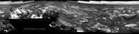
The Navcam L view on Sol 1691.
Jan van Driel
|
|
|
|
|
|
|
May 10 2017, 12:04 PM
Post
#97
|
||
 Senior Member Group: Members Posts: 2428 Joined: 30-January 13 From: Penang, Malaysia. Member No.: 6853 |
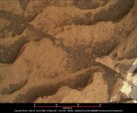
One of a series of pre-drive focus merged MAHLI's from sol 1691. A 30 millimeter scale has been bar added (based on the focus motor count reported for the first image then using Gerald's MAHLI Ruler)
Other MAHLI's from 1691 LINK |
|
|
|
|
|
|
May 10 2017, 02:15 PM
Post
#98
|
|
|
Senior Member Group: Members Posts: 2346 Joined: 7-December 12 Member No.: 6780 |
For the focus-stacked images, the motor count for the first image may be well off-focus. In this case, the motor count of the first image of the stacked image is 13722, while it is 13916 for a sharp similar single image.
Whenever the scale is essential for an investigation, I'd recommend to work with single unstacked images, and apply the scale to the sharpest areas. |
|
|
|
|
May 10 2017, 11:05 PM
Post
#99
|
|
|
Senior Member Group: Members Posts: 2428 Joined: 30-January 13 From: Penang, Malaysia. Member No.: 6853 |
QUOTE (Gerald @ May 10 2017, 10:15 PM) I'd recommend to work with single unstacked images, and apply the scale to the sharpest areas. Thanks Gerald |
|
|
|
|
May 10 2017, 11:14 PM
Post
#100
|
||
|
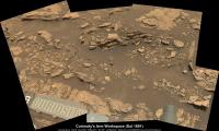
Senior Member Group: Members Posts: 2428 Joined: 30-January 13 From: Penang, Malaysia. Member No.: 6853 |
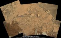
1691 L-MastCam of Curiosity's workspace, assembled in MS ICE, scaled using AlgorimancerPG. Reduced size posted here, LINK to full resolution on IMGUR
|
|
|
|
|
|
|
May 11 2017, 09:03 PM
Post
#101
|
||||
|
Member Group: Members Posts: 866 Joined: 15-March 05 From: Santa Cruz, CA Member No.: 196 |
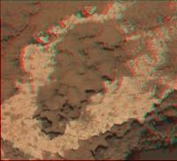
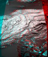
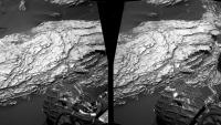
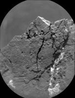
QUOTE (fredk @ May 9 2017, 02:10 PM) If those are focus stacks, that's the kind of thing you expect since the process combines parts of the various images with the best focus. The original images shouldn't show those effects. Thanks! I had no idea the RAW images actually contained stacked products, automated perhaps.. QUOTE (Phil Stooke @ May 9 2017, 02:45 PM) ... That's no MAHLI pin chevron! Those are ChemCam pits in sand, made the day before: http://www.midnightplanets.com/web/MSL/ima...CAM02687L1.html Each new blast pushes sand into the previous pit (each pit is the sum of numerous zaps with the laser). Phil Thanks, a surprising answer I never considered.. That was the explanation I was looking for! This sol1691 m34 may show some of the craziest lacey fillagree so far (at lower middle), its amazing what otherworldly effects saltating fines can have on loosely cemented sedimentary layers at near zero humidity and pressure over geologic timescales. There's no R m100 counterpart, but it was also captured in a less dramatic view by navcam on sol1690 so here's the anaglyph/cross/parallel of that:
|
|||
|
|
|
|||
|
May 11 2017, 09:28 PM
Post
#102
|
|
|
Senior Member Group: Members Posts: 4246 Joined: 17-January 05 Member No.: 152 |
QUOTE (atomoid @ May 11 2017, 10:03 PM) Thanks! I had no idea the RAW images actually contained stacked products, automated perhaps.. That's right, automated - see here for example. You can usually identify the focus stacks pretty easily because they'll be paired with a range map, like this one: http://mars.jpl.nasa.gov/msl-raw-images/ms...878S00_DXXX.jpg |
|
|
|
|
May 13 2017, 11:59 AM
Post
#103
|
||||
|
Senior Member Group: Members Posts: 2428 Joined: 30-January 13 From: Penang, Malaysia. Member No.: 6853 |
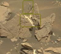
Sol 1693: 2 ChemCam RMI mosaic assembled in MS ICE, raw images, without processing except the stitching. Shown with a R-MastCam context image. This could be the target 'Bear Island mentioned in this mission update
|
|||
|
|
|
|||
|
May 13 2017, 01:26 PM
Post
#104
|
||
|
Senior Member Group: Members Posts: 2820 Joined: 22-April 05 From: Ridderkerk, Netherlands Member No.: 353 |
The Navcam L View on Sol 1693.
Jan van Driel
|
|
|
|
|
|
|
May 13 2017, 02:27 PM
Post
#105
|
||
|
Senior Member Group: Members Posts: 2428 Joined: 30-January 13 From: Penang, Malaysia. Member No.: 6853 |
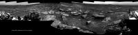
Sol 1693: L-MastCam workspace: Processed in MS ICE. Reduced resolution version to fit the max upload limit of 1Mb.
|
|
|
|
|
|
|

|
Lo-Fi Version | Time is now: 27th April 2024 - 06:32 PM |
|
RULES AND GUIDELINES Please read the Forum Rules and Guidelines before posting. IMAGE COPYRIGHT |
OPINIONS AND MODERATION Opinions expressed on UnmannedSpaceflight.com are those of the individual posters and do not necessarily reflect the opinions of UnmannedSpaceflight.com or The Planetary Society. The all-volunteer UnmannedSpaceflight.com moderation team is wholly independent of The Planetary Society. The Planetary Society has no influence over decisions made by the UnmannedSpaceflight.com moderators. |
SUPPORT THE FORUM Unmannedspaceflight.com is funded by the Planetary Society. Please consider supporting our work and many other projects by donating to the Society or becoming a member. |
|