Martian Cartography |

  |
Martian Cartography |
 Aug 28 2009, 04:50 PM Aug 28 2009, 04:50 PM
Post
#46
|
|
 Senior Member  Group: Members Posts: 2173 Joined: 28-December 04 From: Florida, USA Member No.: 132 |
QUOTE (stevesliva @ Aug 28 2009, 12:35 PM)  ...It's just that when you look at a globe of the earth, and imagine it through a telescope, you won't see rivers.... But you may see a band of enhanced vegetation along them. |
 |
 
|
|
Aug 28 2009, 06:30 PM
Post
#47
|
|
|
Solar System Cartographer Group: Members Posts: 10182 Joined: 5-April 05 From: Canada Member No.: 227 |
Right - the fertile Nile Valley is much wider than the river and shows up clearly against its dry surroundings. The supposed canals were also thought to be surrounded by irrigated land - the canal itself would have been invisible, they all accepted that.
Proctor and others at the time thought Mars was reasonably Earthlike. Lowell had given up on oceans, but Proctor had not. Rivers were a perfectly sensible interpretation of the faint and barely glimpsed markings. More sensible than canals, really. Phil -------------------- ... because the Solar System ain't gonna map itself.
Also to be found posting similar content on https://mastodon.social/@PhilStooke Maps for download (free PD: https://upload.wikimedia.org/wikipedia/comm...Cartography.pdf NOTE: everything created by me which I post on UMSF is considered to be in the public domain (NOT CC, public domain) |
|
|
|
|
Aug 31 2009, 12:59 AM
Post
#48
|
|
|
Member Group: Members Posts: 258 Joined: 22-December 06 Member No.: 1503 |
Those maps are interesting from an historical aspect. It's a nice tour down memory lane.
My interest is mainly concentrated on real surface features of Mars and what they tell us about geologic history. Given that Block Island proves a much thicker atmosphere on Mars in the distant past, what does that tell us about the prospects for ice and water related surface features? Most everything I've been reading lately suggest enormous reservoirs of water ice just underneath the surface of large tracts in many vastly different latitudes of Mars. The more that is found, the more that this suggests there must have been large glacial fields on Mars at one time in the very distant past. Occam's razor tells us that water or ice related processes cannot be logically ignored - as so often has been done in the past. |
|
|
|
|
Aug 31 2009, 09:11 PM
Post
#49
|
||
|
Solar System Cartographer Group: Members Posts: 10182 Joined: 5-April 05 From: Canada Member No.: 227 |
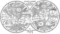
Here's the answer to my map question - the map was published here:
Proctor, R. A., 1888. Maps and Views of Mars. Scientific American, supplement, v. 26, July-December 1888, pp. 10659-10660. It seems that the map is not very well known. The earlier map from 'Other Worlds than Ours' is well known but has different names for many features. I'm assuming I can post this pic of the original as it's 120 years old. For my illustration I reprojected it to match the division into hemispheres that I am using elsewhere. Phil
-------------------- ... because the Solar System ain't gonna map itself.
Also to be found posting similar content on https://mastodon.social/@PhilStooke Maps for download (free PD: https://upload.wikimedia.org/wikipedia/comm...Cartography.pdf NOTE: everything created by me which I post on UMSF is considered to be in the public domain (NOT CC, public domain) |
|
|
|
|
|
|
Aug 31 2009, 09:27 PM
Post
#50
|
|
|
Founder Group: Chairman Posts: 14433 Joined: 8-February 04 Member No.: 1 |
Snow on the poles. I think he can be quite proud of that in 1888

|
|
|
|
|
Sep 1 2009, 12:27 AM
Post
#51
|
|
|
Merciless Robot Group: Admin Posts: 8784 Joined: 8-December 05 From: Los Angeles Member No.: 602 |
Very cool map, thanks for educating (me, at least), Phil!
"Fogland"...interesting. That wouldn't happen to coincide approximately with the Tharsis region, would it? -------------------- A few will take this knowledge and use this power of a dream realized as a force for change, an impetus for further discovery to make less ancient dreams real.
|
|
|
|
|
Sep 1 2009, 05:07 AM
Post
#52
|
|
 Administrator Group: Admin Posts: 5172 Joined: 4-August 05 From: Pasadena, CA, USA, Earth Member No.: 454 |
I like "windy land." Is that Hellas? Appropriate name for the source of planet-encircling dust storms
--Emily -------------------- My website - My Patreon - @elakdawalla on Twitter - Please support unmannedspaceflight.com by donating here.
|
|
|
|
|
Sep 1 2009, 10:48 AM
Post
#53
|
|
|
Solar System Cartographer Group: Members Posts: 10182 Joined: 5-April 05 From: Canada Member No.: 227 |
This original map is south up - mine was north up. So yes, Windy Land is Hellas, but Fog Land is Argyre, not Tharsis!
Phil -------------------- ... because the Solar System ain't gonna map itself.
Also to be found posting similar content on https://mastodon.social/@PhilStooke Maps for download (free PD: https://upload.wikimedia.org/wikipedia/comm...Cartography.pdf NOTE: everything created by me which I post on UMSF is considered to be in the public domain (NOT CC, public domain) |
|
|
|
|
Oct 1 2009, 06:14 AM
Post
#54
|
|
|
Member Group: Members Posts: 890 Joined: 18-November 08 Member No.: 4489 |
QUOTE It's a nice tour down memory lane. i have 12 maps CODE . |-- marte_1960.png |-- marte_1988.png |-- marte_alpo.png |-- marte_antoniadi_1896.png |-- marte_antoniadi_1909.png |-- marte_antoniadi_1930.png |-- marte_demottoni_1957.png |-- marte_green_1877.png |-- marte_lowell_1894.png |-- marte_maggini_1939.png |-- marte_schiapparelli_1881_82.png `-- marte_schiapparelli_1883_84.png all south up , well the image in the scope is upside down without a Barlow lens . the 3 oldest the images are 2048x1024 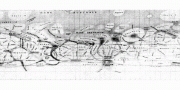 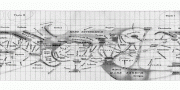 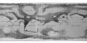 i was having some fun with them years ago in Celestia back in `03 it is interesting how things have changed over the years . From Edgar Rice Burroughs to " it's like the moon" with Merrier then to date with "hay there is melting water STILL " shots from mro and hirise |
|
|
|
|
Oct 1 2009, 08:13 PM
Post
#55
|
||
|
Solar System Cartographer Group: Members Posts: 10182 Joined: 5-April 05 From: Canada Member No.: 227 |
Here's another oldie but goldie:
The 1783 map by William Herschel, drawn in a south polar azimuthal projection, here reprojected into a cylindrical projection with north up. This was the first map of Mars ever compiled. It's often overlooked because of the unusual projection, but in cylindrical projection it's not bad at all. The big dark-ringed shape at the bottom is the residual south polar cap. Phil
-------------------- ... because the Solar System ain't gonna map itself.
Also to be found posting similar content on https://mastodon.social/@PhilStooke Maps for download (free PD: https://upload.wikimedia.org/wikipedia/comm...Cartography.pdf NOTE: everything created by me which I post on UMSF is considered to be in the public domain (NOT CC, public domain) |
|
|
|
|
|
|
Oct 2 2009, 09:06 PM
Post
#56
|
|
|
Member Group: Members Posts: 890 Joined: 18-November 08 Member No.: 4489 |
Phil I did not know of that one
from 1783 cool |
|
|
|
|
Oct 22 2009, 01:31 PM
Post
#57
|
|||
|
Solar System Cartographer Group: Members Posts: 10182 Joined: 5-April 05 From: Canada Member No.: 227 |
Here are a couple of other early maps which I have converted to cylindrical projection for use elsewhere. The Beer and Madler map corrects a mistake in their original. The Green map adds the poles, and in both cases the original grid and text labels have been removed.
Phil Beer and Madler:
Green:
-------------------- ... because the Solar System ain't gonna map itself.
Also to be found posting similar content on https://mastodon.social/@PhilStooke Maps for download (free PD: https://upload.wikimedia.org/wikipedia/comm...Cartography.pdf NOTE: everything created by me which I post on UMSF is considered to be in the public domain (NOT CC, public domain) |
||
|
|
|
||
|
Oct 22 2009, 03:56 PM
Post
#58
|
|
|
Solar System Cartographer Group: Members Posts: 10182 Joined: 5-April 05 From: Canada Member No.: 227 |
I've added an illustration showing five historic maps of Mars, including the three shown above, but all reprojected into a different projection, to my Mars Atlas web page:
http://publish.uwo.ca/~pjstooke/marsatlas.htm This is from the historical intro part of the book. Phil -------------------- ... because the Solar System ain't gonna map itself.
Also to be found posting similar content on https://mastodon.social/@PhilStooke Maps for download (free PD: https://upload.wikimedia.org/wikipedia/comm...Cartography.pdf NOTE: everything created by me which I post on UMSF is considered to be in the public domain (NOT CC, public domain) |
|
|
|
|
Oct 22 2009, 04:01 PM
Post
#59
|
|
 Senior Member Group: Admin Posts: 4763 Joined: 15-March 05 From: Glendale, AZ Member No.: 197 |
Phil I really love the Lunar Book. I can't wait for this one.
-------------------- If Occam had heard my theory, things would be very different now.
|
|
|
|
|
Jun 25 2012, 01:09 AM
Post
#60
|
|
 Member Group: Members Posts: 796 Joined: 27-February 08 From: Heart of Europe Member No.: 4057 |
I did my first map - Martian topography map.
I suppose, that I'll write more info about it tomorrow on my blog. Map is now available as 9MB jpeg (with equivalent resolution 2 km/pix) and if it'll be okay (all comments are welcome!), then I want to upload PDF version (which is much more useful, but also much larger - 56 MB):  -------------------- |
|
|
|
|

|
Lo-Fi Version | Time is now: 3rd June 2024 - 10:21 PM |
|
RULES AND GUIDELINES Please read the Forum Rules and Guidelines before posting. IMAGE COPYRIGHT |
OPINIONS AND MODERATION Opinions expressed on UnmannedSpaceflight.com are those of the individual posters and do not necessarily reflect the opinions of UnmannedSpaceflight.com or The Planetary Society. The all-volunteer UnmannedSpaceflight.com moderation team is wholly independent of The Planetary Society. The Planetary Society has no influence over decisions made by the UnmannedSpaceflight.com moderators. |
SUPPORT THE FORUM Unmannedspaceflight.com is funded by the Planetary Society. Please consider supporting our work and many other projects by donating to the Society or becoming a member. |
|