Zhurong Lander/Rover, Surface Operations at Utopia Planitia |

  |
Zhurong Lander/Rover, Surface Operations at Utopia Planitia |
 Oct 11 2021, 01:32 AM Oct 11 2021, 01:32 AM
Post
#331
|
|
|
Senior Member  Group: Members Posts: 2998 Joined: 30-October 04 Member No.: 105 |
Judging from the accuracy of the daily drives they have autonomous drives and/or the relay down pat.
I'm going to kick around the HiRISE site for a proper map to the Mud Volcano. Any other sources to look at? --Bill -------------------- |
 |
 
|
|
Oct 11 2021, 02:07 AM
Post
#332
|
|
 Senior Member Group: Members Posts: 1420 Joined: 26-July 08 Member No.: 4270 |
In the link I posted, there's an interview with a project scientist that points it out on a map. Even if you don't understand the language, it's pretty easy to follow.
-------------------- -- Hungry4info (Sirius_Alpha)
|
|
|
|
|
Oct 11 2021, 02:10 AM
Post
#333
|
|
|
Founder Group: Chairman Posts: 14432 Joined: 8-February 04 Member No.: 1 |
QUOTE (Bill Harris @ Oct 10 2021, 06:32 PM)  Judging from the accuracy of the daily drives they have autonomous drives and/or the relay down pat. This paper - https://assets.researchsquare.com/files/rs-...df?c=1632507046 - |
|
|
|
|
Oct 11 2021, 03:58 AM
Post
#334
|
|
|
Solar System Cartographer Group: Members Posts: 10153 Joined: 5-April 05 From: Canada Member No.: 227 |
No, Doug - look at the legend on Figure 2a of that paper. Each drive after the first c. 25 sols has a directed drive phase followed by an autonomous drive phase. That corresponds to the entry in Extended Data Table 2 which says "Switching the rover locomotion mode to high efficiency mode" some time after sol 23.
Phil -------------------- ... because the Solar System ain't gonna map itself.
Also to be found posting similar content on https://mastodon.social/@PhilStooke Maps for download (free PD: https://upload.wikimedia.org/wikipedia/comm...Cartography.pdf NOTE: everything created by me which I post on UMSF is considered to be in the public domain (NOT CC, public domain) |
|
|
|
|
Oct 11 2021, 04:11 AM
Post
#335
|
|
|
Founder Group: Chairman Posts: 14432 Joined: 8-February 04 Member No.: 1 |
Oh that's super subtle - I'm surprised they didn't actually mention it in the text anywhere. (I literally searched it for the word auto- but that text is baked into the illustration) This mission is so damned frustrating to try and follow.
|
|
|
|
|
Oct 11 2021, 06:43 AM
Post
#336
|
|
|
Solar System Cartographer Group: Members Posts: 10153 Joined: 5-April 05 From: Canada Member No.: 227 |
Bill: "I'm going to kick around the HiRISE site for a proper map to the Mud Volcano. Any other sources to look at?"
You might try using this site to track down CTX images: https://themis.asu.edu/maps (there are other ways to get into CTX images but this has a nice map interface) Phil -------------------- ... because the Solar System ain't gonna map itself.
Also to be found posting similar content on https://mastodon.social/@PhilStooke Maps for download (free PD: https://upload.wikimedia.org/wikipedia/comm...Cartography.pdf NOTE: everything created by me which I post on UMSF is considered to be in the public domain (NOT CC, public domain) |
|
|
|
|
Oct 11 2021, 01:51 PM
Post
#337
|
|
|
Senior Member Group: Members Posts: 2998 Joined: 30-October 04 Member No.: 105 |
I'll give the Themis site a try.
At HiRISE, just searching on the keyword "zhurong" I did find image strips, and even image strips containing mud volanoes, but didn't see an obvious connection between strips. The topography is fairly a series of random features and it's going to take some time to pick through. I need to determine some Lat-Longs and use them as search parameters. The presser also mentioned a "sand pile" they were keen to investigate. I found an area of different texture that might be it, but they may just be referring to one of the many light-toned barchan-like dunes we see. A very ambitious and successful mission. The only limitation they will run into will be atmospheric Tau and dust accumulation on the solar panels. --Bill -------------------- |
|
|
|
|
Oct 11 2021, 02:07 PM
Post
#338
|
|
|
Senior Member Group: Members Posts: 2998 Joined: 30-October 04 Member No.: 105 |
QUOTE (djellison @ Oct 10 2021, 11:11 PM) Oh that's super subtle - I'm surprised they didn't actually mention it in the text anywhere. (I literally searched it for the word auto- but that text is baked into the illustration) This mission is so damned frustrating to try and follow. And I was largely guessing that autonav was being used, based on how the Rover picks around obstacles. They have gotten ideas on what is possible from the MER rovers, but they have brilliantly implemented the workable system. The mission is tricky to follow. I don't think they are trying to be secretive, they are doing the mission for the mission's sake, but don't have a public outreach built into the infrastructure. It adds interesting dimensions to following the mission having to sleuth things up. --Bill -------------------- |
|
|
|
|
Oct 11 2021, 05:35 PM
Post
#339
|
||
|
Solar System Cartographer Group: Members Posts: 10153 Joined: 5-April 05 From: Canada Member No.: 227 |
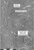
This is my interpretation of the recent discussion about distant targets. I can't see what the sediment pile statement is about if it is not referring to the shallow trough about 3 km south of the landing site (2 km south of the current location). How is a trough a sediment pile? - maybe because its shallowness suggests it is largely filled with sediment. It has lots of discrete drifts (the bright lines in higher resolution images) on the valley floor, but it must also be largely filled with sediment if it was originally like the many other more prominent troughs around it. The ground-penetrating radar may reveal the structures forming the trough walls, which would be a significant observation.
Phil
-------------------- ... because the Solar System ain't gonna map itself.
Also to be found posting similar content on https://mastodon.social/@PhilStooke Maps for download (free PD: https://upload.wikimedia.org/wikipedia/comm...Cartography.pdf NOTE: everything created by me which I post on UMSF is considered to be in the public domain (NOT CC, public domain) |
|
|
|
|
|
|
Oct 12 2021, 12:00 AM
Post
#340
|
||
|
Senior Member Group: Members Posts: 1420 Joined: 26-July 08 Member No.: 4270 |
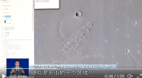
QUOTE (Hungry4info) In the link I posted, there's an interview with a project scientist that points it out on a map. Even if you don't understand the language, it's pretty easy to follow. A lot of time is spent pointing to this feature (see cursor in attached image), rather than the two large cones to the north-west. I suspect this is the intended target.
Attached thumbnail(s)
-------------------- -- Hungry4info (Sirius_Alpha)
|
|
|
|
|
|
|
Oct 12 2021, 06:19 AM
Post
#341
|
|
|
Solar System Cartographer Group: Members Posts: 10153 Joined: 5-April 05 From: Canada Member No.: 227 |
True, but they are about 25 km from the lander and the statement said 20 km to the cone.
Phil -------------------- ... because the Solar System ain't gonna map itself.
Also to be found posting similar content on https://mastodon.social/@PhilStooke Maps for download (free PD: https://upload.wikimedia.org/wikipedia/comm...Cartography.pdf NOTE: everything created by me which I post on UMSF is considered to be in the public domain (NOT CC, public domain) |
|
|
|
|
Oct 12 2021, 08:41 AM
Post
#342
|
|
 Member Group: Members Posts: 185 Joined: 4-January 19 Member No.: 8523 |
https://share.api.weibo.cn/share/255422038.html
https://mobile.twitter.com/CNSAWatcher/stat...840619913678850 [Zhurong Mars Rover faces east during solar transit phase as a trick] Jia Yang, deputy chief designer in CASC, said due to the high temperature of Mars at noon, researchers let the rover face east, so that the rover's mast can block part of the sunshine. I believe, in some point, we will need to have a relay satellite beetween Earth and Mars... -------------------- "The Earth is a very small stage in a vast cosmic arena"
|
|
|
|
|
Oct 13 2021, 02:38 AM
Post
#343
|
|
|
Senior Member Group: Members Posts: 2998 Joined: 30-October 04 Member No.: 105 |
Phil, I agree that the trough must be the "sediment pile" they referred to. This may be another quirk in translation. Remember the confusion with their Farside Lunar Rover when it imaged a vitreous (glassy) patch and there was a big to-do about what they really found.
And the two "cinder cone" mud cones are likely a target. Not knowing Chinese I have no idea why they were pointing to that "mud cone" field in the photo. We'll find out when we find out... --Bill -------------------- |
|
|
|
|
Oct 13 2021, 11:22 AM
Post
#344
|
|
|
Member Group: Members Posts: 185 Joined: 4-January 19 Member No.: 8523 |
QUOTE (Hungry4info @ Oct 11 2021, 09:00 PM) A lot of time is spent pointing to this feature (see cursor in attached image), rather than the two large cones to the north-west. I suspect this is the intended target. I believe they think it will be easier and with more results to analyse a Mud pit area then a Mud single cone. I can't imagine Zhurong going up on a mud cone, but rovering through a cone fileld is other thing... And the concentration on that field may sugest interesting features underground...
-------------------- "The Earth is a very small stage in a vast cosmic arena"
|
|
|
|
|
Oct 14 2021, 07:40 AM
Post
#345
|
|
|
Senior Member Group: Members Posts: 2998 Joined: 30-October 04 Member No.: 105 |
It is tempting to go to a spectacular-looking mud volcano cone but given that Zhurong is equipped with Ground Penetrating Radar that field of mud cones would indeed be scientifically attractive. Perhaps the single cone would be a waypoint on the route to the field.
We will know more once we see the route beyond the Sand Pit. --Bill -------------------- |
|
|
|
|

|
Lo-Fi Version | Time is now: 27th April 2024 - 04:20 AM |
|
RULES AND GUIDELINES Please read the Forum Rules and Guidelines before posting. IMAGE COPYRIGHT |
OPINIONS AND MODERATION Opinions expressed on UnmannedSpaceflight.com are those of the individual posters and do not necessarily reflect the opinions of UnmannedSpaceflight.com or The Planetary Society. The all-volunteer UnmannedSpaceflight.com moderation team is wholly independent of The Planetary Society. The Planetary Society has no influence over decisions made by the UnmannedSpaceflight.com moderators. |
SUPPORT THE FORUM Unmannedspaceflight.com is funded by the Planetary Society. Please consider supporting our work and many other projects by donating to the Society or becoming a member. |
|