Atop/Around the Greenheugh Pediment, Site 79-, sol 2695-3199, 3 Mar 2020-6 Aug 2021 |

  |
Atop/Around the Greenheugh Pediment, Site 79-, sol 2695-3199, 3 Mar 2020-6 Aug 2021 |
 Sep 16 2020, 05:52 PM Sep 16 2020, 05:52 PM
Post
#256
|
|
 Senior Member  Group: Members Posts: 4246 Joined: 17-January 05 Member No.: 152 |
QUOTE (fredk @ Aug 24 2020, 05:57 PM)  Starting around sol 2850 the MSSS images at mars.nasa.gov/msl-raw-images have been provided with incorrect MIME types. This means they won't display correctly in browsers. For example, clicking on this mastcam link: https://mars.nasa.gov/msl-raw-images/msss/0...307C00_DXXX.jpg browsers will typically ask what you want to do with the file or just download it. Clicking on an engineering pic, eg: https://mars.nasa.gov/msl-raw-images/proj/m...NCAM00543M_.JPG will open the image in a new window/tab as it should. I've been parsing the MSL json files into very basic (static) html and thought I could make the pages public in case anyone might find them useful. But the incorrect MSSS MIME types make it really hard to provide useful links to the images. Can anyone suggest someone to contact about the mars.nasa.gov/msl-raw-images server to fix this? I contacted the feedback link nearly a month ago but have gotten no reply. |
 |
 
|
|
Sep 16 2020, 07:02 PM
Post
#257
|
|
|
Member Group: Members Posts: 282 Joined: 18-June 04 Member No.: 84 |
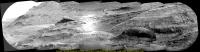
QUOTE (PaulH51 @ Sep 16 2020, 02:49 PM) No issues, just busy testing. Curiosity has recently ingested a sample from the Mary Anning 3 drill hole into SAM and is using the first of its 2 cups of TMAH to see what it can find in the clay unit. The SAM tests are energy hungry and the powdered rock sample remains in the sleeve of the drill so the use of the arm is on hold until the SAM / CheMin analysis is completed. Here's a nice RMI mosaic from earlier today of the target "Housedon Hill" target that lies ~400 meters East of the rover [attachment=46121:Housedon...4_stitch.jpg] The RAW page only works with the new Microsoft Edge Browser. |
|
|
|
|
Sep 16 2020, 09:14 PM
Post
#258
|
|
|
Solar System Cartographer Group: Members Posts: 10151 Joined: 5-April 05 From: Canada Member No.: 227 |
The RAW page on the mission website? No, I'm in it now on Firefox.
Phil -------------------- ... because the Solar System ain't gonna map itself.
Also to be found posting similar content on https://mastodon.social/@PhilStooke Maps for download (free PD: https://upload.wikimedia.org/wikipedia/comm...Cartography.pdf NOTE: everything created by me which I post on UMSF is considered to be in the public domain (NOT CC, public domain) |
|
|
|
|
Sep 17 2020, 06:29 AM
Post
#259
|
|
|
Solar System Cartographer Group: Members Posts: 10151 Joined: 5-April 05 From: Canada Member No.: 227 |
Sol 2884 - the dust devil search saw some very faint dust features over Vera Rubin Ridge. Not very pretty! So I won't post them but the wind is very active at the moment.
Phil -------------------- ... because the Solar System ain't gonna map itself.
Also to be found posting similar content on https://mastodon.social/@PhilStooke Maps for download (free PD: https://upload.wikimedia.org/wikipedia/comm...Cartography.pdf NOTE: everything created by me which I post on UMSF is considered to be in the public domain (NOT CC, public domain) |
|
|
|
|
Sep 17 2020, 07:56 PM
Post
#260
|
|
 Member Group: Members Posts: 809 Joined: 3-June 04 From: Brittany, France Member No.: 79 |
QUOTE (PaulH51 @ Sep 16 2020, 02:49 PM) Here's a nice RMI mosaic from earlier today of the target "Housedon Hill" target that lies ~400 meters East of the rover [attachment=46121:Housedon...4_stitch.jpg] Paul, do you know if there is a MastCam image or mosaic that comes along this RMI mosaic? -------------------- |
|
|
|
|
Sep 17 2020, 08:12 PM
Post
#261
|
|
|
Senior Member Group: Members Posts: 4246 Joined: 17-January 05 Member No.: 152 |
It's in the 2845 mosaic - here's the MR frame:
https://mars.nasa.gov/msl-raw-images/msss/0...029C00_DXXX.jpg (Pre-sol 2850 so the link works.) |
|
|
|
|
Sep 22 2020, 01:27 AM
Post
#262
|
||
 Senior Member Group: Members Posts: 2428 Joined: 30-January 13 From: Penang, Malaysia. Member No.: 6853 |
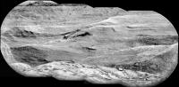
Another long distance RMI mosaic, this time from Sol 2889, 8 frames roughly assembled in MS-ICE, kindly try to ignore the poor processing of the forth frame as it was not pre-processed in the image pipeline like the other 7.
The mission update refers to:- "ChemCam RMI mosaics to document stratigraphy and to investigate the feasibility of extracting stereo information from overlapping RMI images". Fingers crossed they can tease that stereo information from their versions.
|
|
|
|
|
|
|
Sep 25 2020, 07:48 AM
Post
#263
|
||
|
Senior Member Group: Members Posts: 2428 Joined: 30-January 13 From: Penang, Malaysia. Member No.: 6853 |
Curiosity has been busy expanding the long-distance imaging of the terrain around "Housedon Hill" using its RMI-ChemCam while stationed at the Mary Anning sampling site. However some of the 'PNG processed' RMI's have not made it into the raw image server, making it difficult for me to process them into what is a rather nice mosaic.
Background: The JSON page and the MSL raw image server both contain all the RMI's in JPG format, these raw images appear 'unprocessed' as they are very underexposed and heavily vignetted. Thankfully the PNG versions that correct the exposure and vignetting are also loaded in the raw image server, but not on the JSON page I use. Is anyone here aware of a different JSON page where I can download the missing PNG format RMI's, as my processing skills and tools are not developed enough to restore the JPG files. Example: The most recent set of RMI's from Housedon Hill are from sol 2891 Note that there are 10 RMI frames in JPG format, but only 8 frames in PNG format. Here is a mosaic assembled from just 4 of the PNG frames.
|
|
|
|
|
|
|
Sep 25 2020, 12:40 PM
Post
#264
|
||
|
Senior Member Group: Members Posts: 1043 Joined: 17-February 09 Member No.: 4605 |
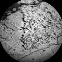
It seems that there will be a third drill adjacent to the Mary Anning site. From the September 23, 2020 update, "...we are already on the look out for the nearby target "Ayton." We want to drill there too, to follow up the chemical changes we have observed in the area."
"Ayton" target:
Attached thumbnail(s)
|
|
|
|
|
|
|
Sep 25 2020, 04:09 PM
Post
#265
|
|
|
Senior Member Group: Members Posts: 4246 Joined: 17-January 05 Member No.: 152 |
QUOTE (PaulH51 @ Sep 25 2020, 08:48 AM) Thankfully the PNG versions that correct the exposure and vignetting are also loaded in the raw image server, but not on the JSON page I use. Is anyone here aware of a different JSON page where I can download the missing PNG format RMI's, as my processing skills and tools are not developed enough to restore the JPG files. That json is the "v2" json and indeed doesn't include the chemcam pngs. There is also the "v1" json file (different format) here (and links therein) which does include the pngs (and thumbnails too), but unfortunately in my experience doesn't show any more images than the public jpeg server. Right now I'm also seeing two jpeg-only images in that 2891 sequence. I don't know why some pngs are missing - I thought those were generated on the ground. |
|
|
|
|
Sep 26 2020, 01:51 AM
Post
#266
|
|
|
Senior Member Group: Members Posts: 2428 Joined: 30-January 13 From: Penang, Malaysia. Member No.: 6853 |
QUOTE (fredk @ Sep 26 2020, 12:09 AM) I don't know why some pngs are missing - I thought those were generated on the ground Many thanks for the additional link, having just checked it there is still only 8 PNG RMI's from that long-distance group, I'll check again later to see if the missing 2 arrive. I also recall the PNG's were generated on the ground from very early on in the mission, but I can't recall which center performed that function, maybe they are not aware some failed to get converted. One could assume it's an automated pipeline that processes the RMI jpg's from the rover, but maybe it rejects images that don't meet certain criteria? I know we could wait until the PDS is updated, but that's not really a viable option for me at this stage in the mission as we'll likely drive a little closer to some of that terrain and be able to image it with the MastCams. It's a pity that some PNG's remain missing as another batch has since arrived that would expand the set even more. |
|
|
|
|
Sep 27 2020, 04:04 PM
Post
#267
|
||
|
Senior Member Group: Members Posts: 1074 Joined: 21-September 07 From: Québec, Canada Member No.: 3908 |
Sol 2894 long-distance RMI mosaic:
|
|
|
|
|
|
|
Sep 27 2020, 05:17 PM
Post
#268
|
|
|
Senior Member Group: Members Posts: 2511 Joined: 13-September 05 Member No.: 497 |
QUOTE (fredk @ Sep 16 2020, 09:52 AM) Can anyone suggest someone to contact about the mars.nasa.gov/msl-raw-images server to fix this? FWIW I asked our group at MSSS and they forwarded the problem on, so I presume the problem is at JPL or whoever they contract with to manage this. But the web site interface seems to have changed since the last time I looked at it, so I'm not sure this is still inconsistent between the science and engineering cameras. -------------------- Disclaimer: This post is based on public information only. Any opinions are my own.
|
|
|
|
|
Sep 27 2020, 05:34 PM
Post
#269
|
||
|
Senior Member Group: Members Posts: 1074 Joined: 21-September 07 From: Québec, Canada Member No.: 3908 |
Sol 2893 long-distance RMI:
|
|
|
|
|
|
|
Sep 28 2020, 05:00 AM
Post
#270
|
|
|
Senior Member Group: Members Posts: 4246 Joined: 17-January 05 Member No.: 152 |
QUOTE (mcaplinger @ Sep 27 2020, 06:17 PM) FWIW I asked our group at MSSS and they forwarded the problem on Much appreciated. And yes, MSSS images added begining yesterday appear to have the correct MIME types again. Someone got the message! |
|
|
|
|

|
Lo-Fi Version | Time is now: 25th April 2024 - 05:40 PM |
|
RULES AND GUIDELINES Please read the Forum Rules and Guidelines before posting. IMAGE COPYRIGHT |
OPINIONS AND MODERATION Opinions expressed on UnmannedSpaceflight.com are those of the individual posters and do not necessarily reflect the opinions of UnmannedSpaceflight.com or The Planetary Society. The all-volunteer UnmannedSpaceflight.com moderation team is wholly independent of The Planetary Society. The Planetary Society has no influence over decisions made by the UnmannedSpaceflight.com moderators. |
SUPPORT THE FORUM Unmannedspaceflight.com is funded by the Planetary Society. Please consider supporting our work and many other projects by donating to the Society or becoming a member. |
|