Journey to Mt Sharp - Part 1A: Darwin, Sol392 [Sep13,'13] to Sol401 [Sep22,'13] (Waypoint 1) |

  |
Journey to Mt Sharp - Part 1A: Darwin, Sol392 [Sep13,'13] to Sol401 [Sep22,'13] (Waypoint 1) |
 Sep 20 2013, 02:31 PM Sep 20 2013, 02:31 PM
Post
#31
|
|
 Senior Member  Group: Members Posts: 4246 Joined: 17-January 05 Member No.: 152 |
Starting to see some clouds as we head towards winter - they're pretty subtle in this new hazcam shot:
http://mars.jpl.nasa.gov/msl-raw-images/pr...FHAZ00206M_.JPG but compare them with this shot from 20 minutes earlier to see that they're not just dust on the optics: http://mars.jpl.nasa.gov/msl-raw-images/pr...FHAZ00206M_.JPG |
 |
 
|
|
Sep 20 2013, 02:51 PM
Post
#32
|
|
 Senior Member Group: Members Posts: 1084 Joined: 19-February 05 From: Close to Meudon Observatory in France Member No.: 172 |
QUOTE (Deimos @ Sep 20 2013, 04:34 PM)  Thanks a lot Deimos, jmknapp and Greenish for your interesting explanations. The boresights and optical FOVs illustration from jmknapp explains it also very well... And as Napoleon said : "A picture is worth a thousand words" ! Thanks again a lot to you all 
|
|
|
|
|
Sep 20 2013, 07:51 PM
Post
#33
|
|
|
Senior Member Group: Members Posts: 4246 Joined: 17-January 05 Member No.: 152 |
Better view of the clouds in this late-afternoon hazcam shot:
http://mars.jpl.nasa.gov/msl-raw-images/pr...FHAZ00215M_.JPG |
|
|
|
|
Sep 20 2013, 10:07 PM
Post
#34
|
||
|
Member Group: Members Posts: 866 Joined: 15-March 05 From: Santa Cruz, CA Member No.: 196 |
thanks for catching the clouds!
more nice MI topography coming down sol399..
|
|
|
|
|
|
|
Sep 21 2013, 02:19 AM
Post
#35
|
||
|
Junior Member Group: Members Posts: 31 Joined: 1-July 13 From: Ithaca, NY Member No.: 6966 |
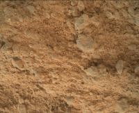
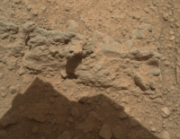
QUOTE (atomoid @ Sep 20 2013, 05:07 PM) more nice MI topography coming down sol399.. Sol 399 MAHLI blink image, cropped, downsized:
|
|
|
|
|
|
|
Sep 21 2013, 12:27 PM
Post
#36
|
||
 Senior Member Group: Members Posts: 1465 Joined: 9-February 04 From: Columbus OH USA Member No.: 13 |
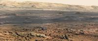
Photoshop from MR sol 395
-------------------- |
|
|
|
|
|
|
Sep 21 2013, 02:12 PM
Post
#37
|
|
 Senior Member Group: Admin Posts: 3108 Joined: 21-December 05 From: Canberra, Australia Member No.: 615 |
That was quick!?!
 Matt Heverly tweeted: # Curiosity is leaving the first scientific waypoint on the route to Mt. Sharp. Only 1.1 km until she stops again at science waypoint 2. |
|
|
|
|
Sep 22 2013, 12:56 AM
Post
#38
|
|
 Administrator Group: Admin Posts: 5172 Joined: 4-August 05 From: Pasadena, CA, USA, Earth Member No.: 454 |
Yes, I'd heard it would just be a few days. They have to really move fast to make it to the mountain by the end of the nominal mission.
-------------------- My website - My Patreon - @elakdawalla on Twitter - Please support unmannedspaceflight.com by donating here.
|
|
|
|
|
Sep 23 2013, 10:43 AM
Post
#39
|
|
|
Senior Member Group: Members Posts: 1465 Joined: 9-February 04 From: Columbus OH USA Member No.: 13 |
Sol 402, 26 meters
Around here, however, we don't look backwards for very long. We keep moving forward, opening up new doors and doing new things, because we're curious and curiosity keeps leading us down new paths. -- Walt Disney -------------------- |
|
|
|
|
Sep 23 2013, 03:22 PM
Post
#40
|
||
 Member Group: Members Posts: 219 Joined: 14-November 11 From: Washington, DC Member No.: 6237 |
Tons of MAHLI imaging on 399-401, including what looks like some stereo in addition to the focus merge depth mapping, and coordinated obs with Chemcam.
Tried a regular mosaic from one sequence on Sol 400 (still a missing a few missing but wanted to see if I could do it). May post a full res if I can when all of them are down. Really need to start paying more attention to the day job...
|
|
|
|
|
|
|
Sep 24 2013, 10:35 AM
Post
#41
|
|
|
Senior Member Group: Members Posts: 2346 Joined: 7-December 12 Member No.: 6780 |
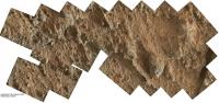
Autostitch of Sol 401 (sol of data product) focus-merged MAHLIs, full-res:
 (7 MB) (7 MB)
|
|
|
|
|
Sep 24 2013, 11:15 PM
Post
#42
|
|||
|
Member Group: Members Posts: 866 Joined: 15-March 05 From: Santa Cruz, CA Member No.: 196 |
|
||
|
|
|
||
|
Sep 26 2013, 10:13 PM
Post
#43
|
|
|
Senior Member Group: Admin Posts: 3108 Joined: 21-December 05 From: Canberra, Australia Member No.: 615 |
ADMIN: A whole lot of posts related to night sky observations have been moved to a new dedicated thread for the subject.
|
|
|
|
|
Mar 25 2014, 06:18 PM
Post
#44
|
|
|
Administrator Group: Admin Posts: 5172 Joined: 4-August 05 From: Pasadena, CA, USA, Earth Member No.: 454 |
QUOTE (Greenish @ Sep 17 2013, 01:47 PM) Here's another long-range RMI image, from Sol 396 looking to the ESE. This is a focus merge of 6 images, flatfielded and contrast enhanced. I am pretty sure it's it's aimed at the location circled in the NAVCAM image below, so the upper half of the image may show the flank of a "mesa" near the dunes (edit: seen also from a slightly different angle in the Sol 389 mastcam image also attached) QUOTE (Greenish @ Sep 17 2013, 02:07 PM) Looks like they also did multispectral MR100 imaging of the same spot on sol 387 (far right side of this image and subsequent 4 IR images). Wonder if they are using the passive spectroscopy capabilities of ChemCam and taking the above images to document it. QUOTE (Phil Stooke @ Sep 17 2013, 02:08 PM) Amazing picture! I think it's here, marked on a pan from sol 364 so not seeing the same foreground features. (so this is the left side, not the far right side, of the pic Greenish just linked to) I learned at LPSC that these images -- M-100s for context and RMIs for detail -- are taken by a group led by Nathan Bridges that is attempting to spot changes in the dune fields at the base of Mt Sharp over time. They're not looking for changes in the big dunes, but rather in the smaller sand ripples atop the dunes. They have not yet spotted any changes, but the comparisons are really hard because of the degree of foreshortening and the long distances involved. Earlier in the mission, right after landing, they got some lossless M-100 images down from the rover (the ones that look gray, because they didn't do the Bayer interpolation) on which they could clearly discern individual ripples. The compressed images they're getting now are not as good for spotting and matching specific ripples, so they're advocating for more lossless M-100 data; otherwise, they depend on RMI images. We'll keep seeing these sets of M-100 and RMI images as they traverse. -------------------- My website - My Patreon - @elakdawalla on Twitter - Please support unmannedspaceflight.com by donating here.
|
|
|
|
|
Mar 26 2014, 04:16 AM
Post
#45
|
|
|
Member Group: Members Posts: 219 Joined: 14-November 11 From: Washington, DC Member No.: 6237 |
Thanks, Emily for this update - great that you were able to get some insight on this.
Now I just need to make the time to reprocess some of those mosaics & focus stacks now that the PDS images are available. The "partially radiometrically calibrated" RDRs for the RMI are way better than the quick look JPGs... not saturated in the center, flatfielded & de-ghosted, and available as 16-bit TIFs (compare an EDR JPG vs PDS TIF) |
|
|
|
|

|
Lo-Fi Version | Time is now: 26th April 2024 - 12:07 AM |
|
RULES AND GUIDELINES Please read the Forum Rules and Guidelines before posting. IMAGE COPYRIGHT |
OPINIONS AND MODERATION Opinions expressed on UnmannedSpaceflight.com are those of the individual posters and do not necessarily reflect the opinions of UnmannedSpaceflight.com or The Planetary Society. The all-volunteer UnmannedSpaceflight.com moderation team is wholly independent of The Planetary Society. The Planetary Society has no influence over decisions made by the UnmannedSpaceflight.com moderators. |
SUPPORT THE FORUM Unmannedspaceflight.com is funded by the Planetary Society. Please consider supporting our work and many other projects by donating to the Society or becoming a member. |
|