2005-feb-15 Titan Flyby (t3) |

  |
2005-feb-15 Titan Flyby (t3) |
 Jan 20 2005, 11:00 PM Jan 20 2005, 11:00 PM
Post
#1
|
|
|
Senior Member  Group: Members Posts: 1276 Joined: 25-November 04 Member No.: 114 |
A little early to start a topic maybe
 I'm just so excited about this flyby. I'm just so excited about this flyby.I do have questions about this flyby. 1. What hemisphere will be imaged on this flyby? 2. Will Radar be used this time? 3. Any Non targeted Observations? (Besides Enceladus) |
 |
 
|
|
Jan 21 2005, 12:30 AM
Post
#2
|
|
 Senior Member Group: Moderator Posts: 3233 Joined: 11-February 04 From: Tucson, AZ Member No.: 23 |
QUOTE (Decepticon @ Jan 20 2005, 04:00 PM) A little early to start a topic maybe I'm just so excited about this flyby.I do have questions about this flyby. 1. What hemisphere will be imaged on this flyby? 2. Will Radar be used this time? 3. Any Non targeted Observations? (Besides Enceladus) 1. Same as last time. No massive regional scale mosaics this time, just some global scale observations and a high resolution set over the T3 RADAR altimetry swath. Don't worry, T4 and T5 on March 31 and April 16 respectively will cover new terrain. Both will cover the sub-saturnian hemisphere. 2. Yes. the swath will be over a little bit farther south than during Ta. Rest assured it will cross a known bright/dark boundary and some interesting albedo features seen by ISS including the multi-ring albedo structure seen here: http://photojournal.jpl.nasa.gov/jpegMod/PIA06154_modest.jpg. 3. There appear to be some distant high phase observations of Mimas, Rhea, Dione, and Tethys, designed, when combined with this orbit and subsquent orbits, to map out the variations in scattering properties of the surfaces of these moons. -------------------- &@^^!% Jim! I'm a geologist, not a physicist!
The Gish Bar Times - A Blog all about Jupiter's Moon Io |
|
|
|
|
Jan 21 2005, 12:54 AM
Post
#3
|
|
|
Senior Member Group: Members Posts: 1276 Joined: 25-November 04 Member No.: 114 |
QUOTE 2. Yes. the swath will be over a little bit farther south than during Ta. Rest assured it will cross a known bright/dark boundary and some interesting albedo features seen by ISS including the multi-ring albedo structure seen here: http://photojournal.jpl.nasa.gov/jpegMod/PIA06154_modest.jpg. Great! Looking forward to that. |
|
|
|
|
Feb 1 2005, 03:34 AM
Post
#4
|
|
|
Senior Member Group: Members Posts: 1276 Joined: 25-November 04 Member No.: 114 |
2 weeks to go!
I'm already excited! *Trys to Kick start thred* |
|
|
|
|
Feb 3 2005, 09:33 PM
Post
#5
|
|
|
Member Group: Members Posts: 154 Joined: 8-June 04 Member No.: 80 |
Will the Huygens landing site be studied further on this flyby? I think VIMS reveals the surface of Titan better than ISS. Will VIMS be used to on this flyby too?
|
|
|
|
|
Feb 3 2005, 10:31 PM
Post
#6
|
|
|
Senior Member Group: Moderator Posts: 3233 Joined: 11-February 04 From: Tucson, AZ Member No.: 23 |
QUOTE (pioneer @ Feb 3 2005, 02:33 PM) Will the Huygens landing site be studied further on this flyby? I think VIMS reveals the surface of Titan better than ISS. Will VIMS be used to on this flyby too? No, neither ISS nor VIMS take a good look at the landing site. We have some 1.4 km/pixel imaging of the area, but frankly we have better images of the area on the ground already. In terms of what VIMS will be doing, they will mostly be riding along with other instruments but they will get observations. Now, about that comment regarding what VIMS and ISS can see. VIMS can see Titan at farther infrared wavelengths than ISS can. As waavelength increases, optical depth decreases. So at the same pixel scales, VIMS can see more surface contrast than ISS can However, this only becomes at factor at the highest resolution, for VIMS, this is at around 2km/pixel. At that point they can see greater detail than even our best images. However, we can plan our images to mitigate this. First, we can use longer exposure times and more images at the same footprint to improve SNR. Second, we can look much closer to the sub-spacecraft point on the highest resolution observations to improve observed contrast by not looking through so much atmosphere. Combining these steps, we should see better than VIMS at our highest resolution. But it is true, that at the same pixel scale, VIMS can see more detail. -------------------- &@^^!% Jim! I'm a geologist, not a physicist!
The Gish Bar Times - A Blog all about Jupiter's Moon Io |
|
|
|
|
Feb 4 2005, 01:24 PM
Post
#7
|
|
|
Senior Member Group: Members Posts: 1276 Joined: 25-November 04 Member No.: 114 |
VP will the Images be more to the east compared to the last flybys?
|
|
|
|
| Guest_BruceMoomaw_* |
Feb 5 2005, 04:48 AM
Post
#8
|
|
Guests |
In his recent very informative NAI lecture, Don Lunine agreed that the best resolution for VIMS at Titan is indeed about equal to the best possible resolution for ISS, IF -- and it's a big if -- the latter is handled the right way. The reason, sez he, is that VIMS' CCDs aren't as sensitive as those on the ISS cameras.
|
|
|
|
|
Feb 13 2005, 05:14 PM
Post
#9
|
|
 Member Group: Members Posts: 809 Joined: 11-March 04 Member No.: 56 |
There are a couple of new images of Titan available from jpl:
http://saturn.jpl.nasa.gov/multimedia/imag...eiImageID=31851 http://saturn.jpl.nasa.gov/multimedia/imag...eiImageID=31850 |
|
|
|
|
Feb 13 2005, 08:34 PM
Post
#10
|
|
|
Senior Member Group: Members Posts: 1276 Joined: 25-November 04 Member No.: 114 |
^ Very Nice!
Looking forward to the radar map. I wonder whats taking so long for a Titan global map updates with the previous flybys. |
|
|
|
| Guest_Sunspot_* |
Feb 13 2005, 08:44 PM
Post
#11
|
|
Guests |
QUOTE (David @ Feb 13 2005, 05:14 PM) There are a couple of new images of Titan available from jpl: http://saturn.jpl.nasa.gov/multimedia/imag...eiImageID=31851 http://saturn.jpl.nasa.gov/multimedia/imag...eiImageID=31850 Those pictures arrived on Earth yeaterday, i've been clicking on "Browse latest 500 RAW images" - which doesn't see to bring up the latest images lol Using the search and WA/NA camera filters does. |
|
|
|
|
Feb 13 2005, 09:20 PM
Post
#12
|
||
 Interplanetary Dumpster Diver Group: Admin Posts: 4404 Joined: 17-February 04 From: Powell, TN Member No.: 33 |
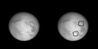
Looks like some interesting features. Here is my enhancement. Two circular features look interesting.
Attached thumbnail(s)
-------------------- |
|
|
|
|
|
|
Feb 13 2005, 09:44 PM
Post
#13
|
|
|
Senior Member Group: Members Posts: 1276 Joined: 25-November 04 Member No.: 114 |
QUOTE (tedstryk @ Feb 13 2005, 04:20 PM) Looks like some interesting features. Here is my enhancement. Two circular features look interesting. Cool! My guess : Ice Volcanos! ,<Wishful thinking. What did you do to bring the detail out?[B] |
|
|
|
|
Feb 13 2005, 10:12 PM
Post
#14
|
|
|
Member Group: Members Posts: 809 Joined: 11-March 04 Member No.: 56 |
Those features are also seen in an image that Sunspot posted to the Titan Surface Features topic on 12/17/04:
 I thought at first that the bright semicircle had to be a cloud, but it is seen on the image from two months ago and has not changed. The more northerly structure definitely strikes me as a large impact crater that has been modified by fluids, something like Lake Manicouagan in Quebec. The other feature seems odder. A mountain range left over from an impact? Or raised by some other process, like vulcanism? |
|
|
|
|
Feb 13 2005, 11:27 PM
Post
#15
|
|
|
Interplanetary Dumpster Diver Group: Admin Posts: 4404 Joined: 17-February 04 From: Powell, TN Member No.: 33 |
I created a mask based on smoothed versions of images that only showed the atmosphere. I then partially subtracted an enhanced contast version of this from the original image. That brought out surfaced details without making the image look too terribly awkward. I would have done more, but the jpeg effects in the original image made this not useful. I think the Lake Lake Manicouagan analogy and the volcano idea are possible. Hopefully radar will cross one of these regions soon. Remember, after Mariner 7 they thought Nix Olympica was a crater. Nix Olympica ("Snows of Olympus," so-called because it is often surrounded by clouds and thus looked bright in groundbased telescopes without the resolution to reveal its true nature) turned out to be Olympus Mons. I doubt there is anything of that scale in terms of topography on Titan, but I bring this up to say you never know what a feature might be from imagery of this quality.
Ted -------------------- |
|
|
|
|

|
Lo-Fi Version | Time is now: 27th April 2024 - 03:51 AM |
|
RULES AND GUIDELINES Please read the Forum Rules and Guidelines before posting. IMAGE COPYRIGHT |
OPINIONS AND MODERATION Opinions expressed on UnmannedSpaceflight.com are those of the individual posters and do not necessarily reflect the opinions of UnmannedSpaceflight.com or The Planetary Society. The all-volunteer UnmannedSpaceflight.com moderation team is wholly independent of The Planetary Society. The Planetary Society has no influence over decisions made by the UnmannedSpaceflight.com moderators. |
SUPPORT THE FORUM Unmannedspaceflight.com is funded by the Planetary Society. Please consider supporting our work and many other projects by donating to the Society or becoming a member. |
|