Printable Version of Topic
Click here to view this topic in its original format
Unmanned Spaceflight.com _ Earth Observations _ TerraSAR-X and TanDEM-X
Posted by: Schillrich May 23 2010, 08:05 AM
Hello,
I am from Germany, my name is Daniel and I am new to unmannedspaceflight.com. I have not found a thread about the German TerrarSAR-X (and soon TanDEM-X) mission. So started this thread and plan to give some report about that mission from time to time.
TerraSAR-X was launched in 2007 and circles the earth on a dusk-dawn-orbit at about 514 km altitude. It maps Earth's surface with a phased array X-band SAR-antenna. Soon its twin TanDAM-X will be launched into to almost the same orbit. In their dual mission the 2 satellites will fly as close as 200m for a long duration to produce stereoscopic radar images of the surface.
Here is one recent picture of Earth: Mexico City mapped with 4 months in between: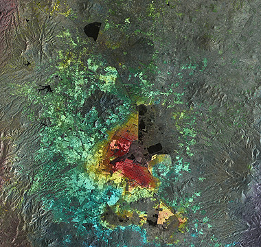
(DLR): http://www.dlr.de/Portaldata/1/Resources/portal_news/newsarchiv2010_3/mexico_city_hires.jpg
Interesting details are the red marked areas. These areas were lowered by 10cm in 4 months (I think that makes about 4 inch  ). The reason behind this is the high water consumption from local wells. The areas without any color overlay could not return useful radar data for this oberservation due to high vegetation density, which changes in itself rapidly.
PS: If I have missed an existing thread ... feel free to relocate this first posting.
Posted by: stevesliva May 23 2010, 04:12 PM
I don't believe there was a TerraSAR thread here. I'm sure the instruments and orbits aren't necessarily that similar, but I've always stumbled upon this mission when searching for SAR imagery of earth geology to compare to Titan. Is there even a good web resource of the public releases from this mission? What's available freely? Anything? Just raw data and not imagery?
Posted by: Schillrich May 23 2010, 09:26 PM
Hi,
there will not be many public resources or even access to raw data. That mission is a private-public partnership or joint venture. The acquired data is marketed by the Infoterra GmbH (limited).
Posted by: MahFL May 24 2010, 02:43 PM
So what happens when all the water is used up, if that is possible, could there be a catastrophic collapse ?
Posted by: Schillrich May 24 2010, 04:38 PM
Hi,
I am no expert in that field but that should be rather unlikely. The ground underneath compacts due to loss of volume. There will not be a collapse. It will have (and already has) impact on the local infrastructure, nevertheless.
Posted by: Schillrich May 25 2010, 09:40 AM
Some other interesting TerraSAR-X picture:
Radar image of the ISS taken from a distance of 195km on March 1rth 2008
(DLR): http://www.dlr.de/Portaldata/1/Resources/portal_news/newsarchiv2010_1/iss_radarbild_HiRes.jpg
Radar "prefers" edges and corners over plain surfaces, which tend to reflect the rays away from the antenna/source, hence the pronounced truss elements and grid elements of the solar arrays in the picture. The picture was taken almost directly from above. Earth's surface is not visible, because the antenna was tuned to register the reflected signals only within a small time window of 1.3 ms so that the signals from the surface had not yet returned to the satellite.
Posted by: Schillrich May 28 2010, 06:23 PM
TSX also saw the earth quake on Haiti.
Ground displacement on Haiti 
(DLR): http://www.dlr.de/Portaldata/1/Resources/raumfahrt/terrasar-x_tandem-x/haiti_groundmotion.jpg
The map shows the ground displacement observed between 2 radar passes on 18th February 2009 and 14th January 2010. The vectors indicate the direction and the colors the magnitude of the displacement. The red areas moved about 1,3 - 2m to the west. The accuracy is about 30cm.
Interesting (and for me still unexplained) are the singular red areas along the coast, for example in the bay of Port-au-Prince.
Posted by: Juramike May 28 2010, 10:06 PM
Underwater mudslides of loose sediments?
Posted by: Schillrich May 29 2010, 07:40 PM
Hi,
good idea, but unlikely. I doubt that the radar beams of TSX penetrate below the water surface. Otherwise we should see more details of subsurface structures on the pictures. There are other pictures of TSX where water surfaces always appear smooth and dark, explained by uniform radar echoes from the surface itself.
But the idea of an xyz-slide could be the explanation, still. Some strong local displacement, not of the ground as a whole but of surface material, could well account for the "red dots" scattered across the map.
Powered by Invision Power Board (http://www.invisionboard.com)
© Invision Power Services (http://www.invisionpower.com)