Apollo Sites from LRO |

  |
Apollo Sites from LRO |
 Jul 28 2009, 09:54 AM Jul 28 2009, 09:54 AM
Post
#121
|
|
 Senior Member  Group: Members Posts: 1465 Joined: 9-February 04 From: Columbus OH USA Member No.: 13 |
QUOTE (John Moore @ Jul 27 2009, 03:19 PM)  ..."Here Mankind left the slavery of Terra's tyrannical gravity Behind and dipped its first, trembling toe in the surf Or, as Buzz Aldrin put it: "Contact light." We never got the chance to send poets to the Moon, alas. -------------------- |
 |
 
|
|
Jul 28 2009, 10:49 AM
Post
#122
|
|
|
Member Group: Members Posts: 156 Joined: 22-May 09 From: Ireland Member No.: 4792 |
QUOTE (AndyG @ Jul 28 2009, 10:44 AM) "but it'll not rise and set for most locations on the Moon." Andy Ah, Andy...you're one of those Nearsider occupants  I have condo's at both poles, and two luxury villas -- each one located on the eastern and western limbs of the Moon (as viewed from Earth) respectively. So both latitudinal and longitudinal 'libration' effects of the Moon allows me to see Earth rises and sets, roughly, every 14 days or so I've currently set up renting options for all properties, so give me a ring sometime John |
|
|
|
|
Jul 28 2009, 12:30 PM
Post
#123
|
||
|
Member Group: Members Posts: 156 Joined: 22-May 09 From: Ireland Member No.: 4792 |
QUOTE (dvandorn @ Jul 27 2009, 11:50 PM) Re: Star crater There's a reference here (http://history.nasa.gov/alsj/a14/A14BoulderCommCheck.pdf) to 'Star Crater' in this Oct 5, 1970 Traverse changes PDF file (see image -- orietated and annoated to view better). It mentions in page three "In Test 1, traverse into and across Star Crater, a small but relatively deep crater..." The image in the PDF file (some pages down) is very poor, but it does show mention of "Star Rim", however, the exact location isn't very clear. Just below the image page in Table I, there's also a mention on the EVA 1 (extensions), and one sold, roughly, wrk out where Star Crater is from this , as they write "Continue from Star Crater to flat region NE of Star Crater and return to LM." John |
|
|
|
|
|
|
Jul 28 2009, 01:39 PM
Post
#124
|
|||
|
Solar System Cartographer Group: Members Posts: 10150 Joined: 5-April 05 From: Canada Member No.: 227 |
It's all in the atlas!
I've attached two composites of figures from my book. First Apollo 13:
It includes an overview identifying Star and Sunrise craters, the main substitutes for Cone if they had to land long. But the very fresh Cone was always the preferred target. Lovell couldn't have seen Star crater - the 'Star' at Fra Mauro was in darkness during both of his trips to the Moon, and they only saw the far side on Apollo 13 (there's a map of planned and actual image coverage in my book too). It wouldn't have been if they had landed, obviously, but it was during the Apollo 13 flyby. I never saw a landing target east of Cone, I think Doug is mistaken on that point. And Apollo 14:
Showing slightly modified landing points and EVAs. These EVA plans are taken from the flight plans for each mission with some additions (there were several versions of the route in the Doublet crater area). All those plans were seen at the LPI library. To answer Doug's original question, Star and Sunrise are in the LROC image, and my overview will make it easy to find them. Phil -------------------- ... because the Solar System ain't gonna map itself.
Also to be found posting similar content on https://mastodon.social/@PhilStooke NOTE: everything created by me which I post on UMSF is considered to be in the public domain (NOT CC, public domain) |
||
|
|
|
||
|
Jul 28 2009, 04:16 PM
Post
#125
|
|
|
Member Group: Members Posts: 813 Joined: 29-December 05 From: NE Oh, USA Member No.: 627 |
[quote name='Phil Stooke' date='Jul 26 2009, 07:20 AM' post='143881']
Love these landslides on a crater wall south of the Apollo 14 site. Phil Me Too... with the LROC resolution, will be great to compare sites with HRIS on Mars. Dust slides on Selene with similar morphologies on Mars. What constitutes a 'gully' made by possible volatiles, vs a dry dust slide as on Selene... Comparative planetology, Babie!!!! Craig |
|
|
|
|
Jul 29 2009, 06:37 AM
Post
#126
|
|
|
Newbie Group: Members Posts: 4 Joined: 27-July 09 Member No.: 4881 |
I gotta say the more and more I look at the LRO pics, they are beginning to far exceed my expectations. The thread that blew my mind was this french thread posted earlier in this thread. A certain poetic phrase caught my eye, ombre double du rocher 1...
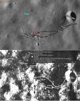
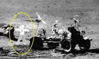
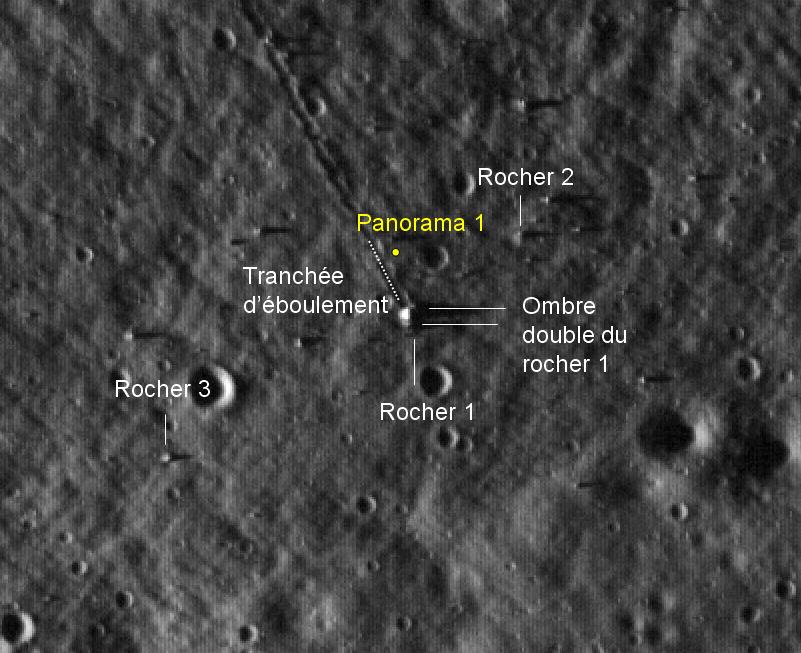 ombre double du rocher 1... the double shadow of Rock 1... Two white lines darting over to what is most certainly a rock at the end of a very strange and obviously straight trench, a boulder path. The two white lines are covering up the two shadows. Laying scattered across the moon like a giant golf ball settling in to a sand trap, likely flung off from another larger impact site some ways away. This is the great rocks of Geology Station 6, a beautiful vista and home of one of the strangest and most easily identified objects from the Apollo missions. Here's a fun diagram of the rocks you should look at before looking at the LRO photo again.  In the diagram we can see the rock has split into a few big junks, two big bits essentially laying next to eachother with a big gap in between, a gap that runs straight east and west. NASA really did us a favor taking it with the sun so low, in les ombres the features of everything in the LRO pics just pop. Okay now check it out without the labels and take in the double shadow of Rock 1, running along east and west. And of course Rocher 1 can be seen quite nicely in this gorgeous panoramic taken at the bottom of that deep sand-trap on the Apollo 17 mission (the spot where it is taken is annotated on the first pic), our two chunks of the discarded golf ball, even at this noon hour with the sun high in the sky le ombre double is quite evident. This one's huge so i'll just post a link: http://upload.wikimedia.org/wikipedia/comm...C_station_6.jpg A smaller version avec les annotes francais: 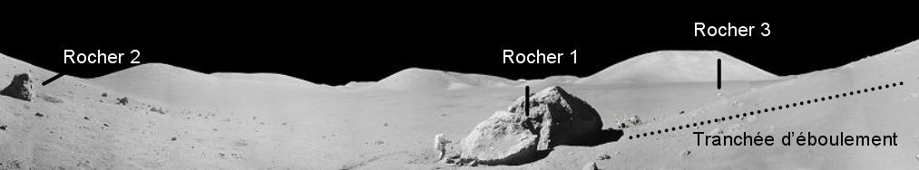 I like to make that one huge on my monitor and just stare at the whole vista for a quarter hour just taking in the beauty and the realness of this huge natural but clearly alien landscape. Everything sounds better in french, Trancheé d'éboulement sounds better than 'boulder path'. 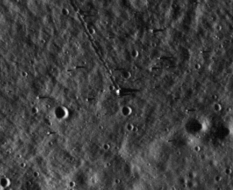 Rocher 1 is either a meteor or a bit of moon kicked up by the collision of a meteor, but it is also a unique monument placed there on the moon, by the moon. We have some very good pictures of it from both high up and up close on to the ground and it is a strikingly recognisable from any angle and any elevation. The gap gives it away, like a brutalist lunar Stonehenge; the gap marking out east and west as it dances with the sun, throwing out l'ombre double. Even at the disappointment educing initial shots level of resolution of the LRO pics (pictures NASA managed to get to us quite a bit sooner than I think anyone was really expecting, and there's no disappointment in that...hats off to you, NASA!) it stands out quite nicely. Christmas day isn't here yet tho, we'll get to open our real presents soon though  This is just the preview! This is just the preview!Anyway, I have been really mulling over the great stuff in this thread and joined the website, and wanted to share some really cool evidence that really physically connects you to a place they just took a picture of from a camera in the sky, a place we've been before, without a doubt. Figure that'll make a good first post. -- SMP p.s. there is a second panorama taken from a spot just west of the big chunk and we can see the sun high in the eastern sky, roughly in line with the gap. 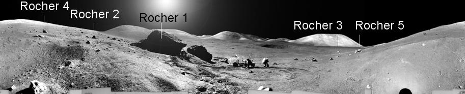 and here's the ginormous version for lunar meditation. |
|
|
|
|
Jul 29 2009, 08:40 AM
Post
#127
|
|
 Member Group: Members Posts: 547 Joined: 1-May 06 From: Scotland (Ecosse, Escocia) Member No.: 759 |
The rock is not a meteor, it's a melt breccia created by meteor impact. Someone has added a jokey cut-out figure next to the LRV in the big version of the last pan.
|
|
|
|
|
Jul 29 2009, 09:08 AM
Post
#128
|
|
|
Newbie Group: Members Posts: 4 Joined: 27-July 09 Member No.: 4881 |
QUOTE (kenny @ Jul 29 2009, 03:40 AM) The rock is not a meteor, it's a melt breccia created by meteor impact. Someone has added a jokey cut-out figure next to the LRV in the big version of the last pan. I can't wait for the nutters to construct a conspiracy theory around Flat Stanley. Surely whatever middleschool class printed this out and asembled it is in on it with NASA. More sinister though is what I'm pretty sure is a bright photoshop lens flare covering up probably the real lens flares of the real sun which might be a wee bit up more, the 7th grade photoshop guru is heading up the caper. Since these are a bunch of little photos put together as a panoramic each picture would have it's own little lens flare. I think i've seen other moon pano's like that. |
|
|
|
|
Jul 29 2009, 11:58 AM
Post
#129
|
|
|
Solar System Cartographer Group: Members Posts: 10150 Joined: 5-April 05 From: Canada Member No.: 227 |
It's common to fix the messy sky in panoramas - many of our UMSF colleagues have done the same with Mars Rover panoramas. But what's the problem with the figure near the rover in the big pan? Looks like Gene to me...
Phil PS for the record, Dale Hubert of Flat Stanley fame is my neighbour here in London, Ontario. -------------------- ... because the Solar System ain't gonna map itself.
Also to be found posting similar content on https://mastodon.social/@PhilStooke NOTE: everything created by me which I post on UMSF is considered to be in the public domain (NOT CC, public domain) |
|
|
|
|
Jul 29 2009, 03:33 PM
Post
#130
|
||
 Senior Member Group: Members Posts: 2173 Joined: 28-December 04 From: Florida, USA Member No.: 132 |
QUOTE (Phil Stooke @ Jul 29 2009, 06:58 AM) ...what's the problem with the figure near the rover in the big pan? Looks like Gene to me... 
|
|
|
|
|
|
|
Jul 29 2009, 04:02 PM
Post
#131
|
|
|
Solar System Cartographer Group: Members Posts: 10150 Joined: 5-April 05 From: Canada Member No.: 227 |
Oh, THAT figure! I'm going to have to have a word with Dale.
Phil -------------------- ... because the Solar System ain't gonna map itself.
Also to be found posting similar content on https://mastodon.social/@PhilStooke NOTE: everything created by me which I post on UMSF is considered to be in the public domain (NOT CC, public domain) |
|
|
|
|
Jul 29 2009, 05:19 PM
Post
#132
|
|
 Senior Member Group: Members Posts: 3419 Joined: 9-February 04 From: Minneapolis, MN, USA Member No.: 15 |
Ah, Photoshop -- so many nice things one can do with it...
Thanks for the Fra Mauro details, Phil. Looking at it now, I can see why Star crater was never very visible in the photocopy-quality images I've seen in .pdf files. It's not very big at all, just has a rather bright halo (making me believe it would have been difficult to find from the surface, akin to how difficult it was to find Halo crater for the 12 crew). Looks to me like Sunrise would have been a much better choice for getting deep samples. Also good to see that the planning for 14 also included some downrange-dispersion EVA plans. By the time we got to the official Apollo 14 press kit and such, they were really only showing the prime site and EVA routes. I do have to wonder, though, whether you might get some different types of rocks from Sunrise vs. Cone. The Imbrium basin ejecta blanket on which the Fra Mauro site is located was rather ropy in texture, emplacing itself in thick, ropy ridges and leaving apparently thinner layers in the valleys between the ridges. Cone was created by a later impact onto the top of one of the thick, ropy ridges (named by the Apollo planners after the crater, Cone ridge). Sunrise seems to have been a similar impact (roughly the same size as Cone, no more than 20% smaller) but into the inter-ridge valley terrain. While I don't believe that either impact could have drilled down beneath the Imbrium ejecta blanket, it would be interesting to compare the mineralogy of samples from the Cone rim to samples from Sunrise's rim. It could tell us whether the uneven-ness of the ejecta, as emplaced, is simply a function of the motion of the ejecta as it re-impacted the surface (wave dynamics and such) or whether there are compositional differences in the possibly thinner, less viscous material that filled in the valleys from the thicker, more viscous material that created the ropy ridges. -the other Doug p.s. -- I think that Lovell's comment of "still looking for Star crater" was more along the lines of exaggeration for effect -- rather like someone who had a layover at the San Francisco airport on a very foggy day at the Bay, saying to friends asking about the trip "Well, I'm still looking for the Golden Gate bridge." -dvd
-------------------- The trouble ain't that there is too many fools, but that the lightning ain't distributed right. -Mark Twain
|
|
|
|
|
Jul 29 2009, 05:59 PM
Post
#133
|
|
 Member Group: Members Posts: 290 Joined: 29-December 05 From: Ottawa, ON Member No.: 624 |
Are there any traverse maps for the original Apollo 14 landing site at Littrow? (had Apollo 13 been successfull)
|
|
|
|
|
Jul 29 2009, 06:42 PM
Post
#134
|
|
|
Senior Member Group: Members Posts: 3419 Joined: 9-February 04 From: Minneapolis, MN, USA Member No.: 15 |
IIRC, traverse planning was done for both the H-mission Littrow site and for the H-mission Censorinus site. Had Apollo 14 been able to fly in July of 1970 (per the original every-four-month schedule following the first successful landing), I believe the Littrow site would have been unavailable, and the Censorinus site would have been used. For the October, 1970 date that was settled on after the flights were spread out to every five to six months, Littrow was to have been the site.
Phil likely has the traverse plans for both sites. I just recall that the Censorinus landing point was a kilometer or less west of the crater proper, and the second EVA would have taken then back east to the crater rim. The Littrow site was, I want to say, about 20 km west of the mouth of the valley of Taurus-Littrow, near a wrinkle ridge. The second EVA at that site would have been a walking tour of the wrinkle ridge. -the other Doug -------------------- The trouble ain't that there is too many fools, but that the lightning ain't distributed right. -Mark Twain
|
|
|
|
|
Jul 29 2009, 06:48 PM
Post
#135
|
|
|
Solar System Cartographer Group: Members Posts: 10150 Joined: 5-April 05 From: Canada Member No.: 227 |
I've looked at more EVA plans than most people still alive, and I never saw a specific EVA plan for Littrow - it was abandoned too early for that. But there were studies of sampling areas. They would have landed at the south edge of the 'ghost crater' where a wrinkle ridge meets the elevated dark mantle area, and would have sampled the mare, the dark-mantle hills and the wrinkle ridge. (Fig. 192 in my book).
Phil -------------------- ... because the Solar System ain't gonna map itself.
Also to be found posting similar content on https://mastodon.social/@PhilStooke NOTE: everything created by me which I post on UMSF is considered to be in the public domain (NOT CC, public domain) |
|
|
|
|

|
Lo-Fi Version | Time is now: 24th April 2024 - 07:36 AM |
|
RULES AND GUIDELINES Please read the Forum Rules and Guidelines before posting. IMAGE COPYRIGHT |
OPINIONS AND MODERATION Opinions expressed on UnmannedSpaceflight.com are those of the individual posters and do not necessarily reflect the opinions of UnmannedSpaceflight.com or The Planetary Society. The all-volunteer UnmannedSpaceflight.com moderation team is wholly independent of The Planetary Society. The Planetary Society has no influence over decisions made by the UnmannedSpaceflight.com moderators. |
SUPPORT THE FORUM Unmannedspaceflight.com is funded by the Planetary Society. Please consider supporting our work and many other projects by donating to the Society or becoming a member. |
|