The Top of Vera Rubin Ridge Part 2, Site 67-73, sol 1944-2297, 24 Jan 2018-22 Jan 2019 |

  |
The Top of Vera Rubin Ridge Part 2, Site 67-73, sol 1944-2297, 24 Jan 2018-22 Jan 2019 |
 Nov 7 2018, 06:52 AM Nov 7 2018, 06:52 AM
Post
#556
|
|
|
Solar System Cartographer  Group: Members Posts: 10145 Joined: 5-April 05 From: Canada Member No.: 227 |
It is a combination of appearance from orbit and in situ observations of veins and other characteristics. This abstract from LPSC this year gets into it a bit, and the poster which accompanied it showed the boundaries and member names I have used in my maps.
Phil https://www.hou.usra.edu/meetings/lpsc2018/pdf/1769.pdf -------------------- ... because the Solar System ain't gonna map itself.
Also to be found posting similar content on https://mastodon.social/@PhilStooke NOTE: everything created by me which I post on UMSF is considered to be in the public domain (NOT CC, public domain) |
 |
 
|
|
Nov 7 2018, 12:00 PM
Post
#557
|
|
|
Senior Member Group: Members Posts: 1074 Joined: 21-September 07 From: Québec, Canada Member No.: 3908 |
Sol 2221 Lmastcam view:
|
|
|
|
|
Nov 7 2018, 01:15 PM
Post
#558
|
|
 Member Group: Members Posts: 684 Joined: 24-July 15 Member No.: 7619 |
QUOTE (jccwrt @ Nov 5 2018, 06:02 PM)  Curiosity is still in the Murray fm (upper Vera Rubin Ridge aka Jura mbr.) which is still a mudstone, but with odd highly oxidized patches. Last I heard (a few months ago), the interpretation was some odd diagenetic event taking place within this section of the Murray. ... dust stone deposits might become more common further up the mountain Ah, thanks, interesting links! I was thinking about dust deposits in terms of midwest salt-lakes/salt flats - aeolian dust accumulates over years or decades, with liquid-lakes occurring every few decades or centuries. Two basic ideas First was that liquid water at Gale would likely be covered by surface ice much of the time; similar to an artic-circle ice-over lake situation; lake levels rise and fall, but the the lake surface is iced over. Second, a recent paper calculated that global dust storms might generate large amounts of perchlorate bound to dust. So, I thinking about what would happen if global dust storms dump perchlorate enriched dust on the ice surface; that accumulates over the span of decades; periodic thawing dumps accumulated dust and perchlorate into the lake. That might provide the impetus for localized oxidation events |
|
|
|
|
Nov 8 2018, 12:23 AM
Post
#559
|
|
|
Senior Member Group: Members Posts: 1043 Joined: 17-February 09 Member No.: 4605 |
The Murray formation including Vera Rubin Ridge is a bit of an enigma and when it formed the Martian environment was far more robust than today's benign, erosional end state. While we can hypothesise, despite multiple erudite papers we aren't really sure what was going on. To put this in perspective, imagine trying to explain coal deposits in Antarctica based on the current Antarctic environment.
From the Pahrump Hills to the top of the ridge the Murray mudstone formation indicates rythmic deposition with narrow, discontinuous lamina and some sandstone lenses and a lot of the features are contradictory. For example Abigail Fraeman's 10.08.2018 mission update indicated that the Mojave gypsum crystals "grew at the interface between loose, water-logged sediment and either shallow water or air". Yet the physical aspects suggest traction sedimentation in deeper water. Heydari et al presented a paper at the ACE June convention noting the lack of any indication of shallow water such as wave ripples, exposure surfaces, strandlines, aeolian characteristics etc and argued that the sandstone lenses seemed indicative of subaqueous channels (chutes)or channel levee complexes. In short fan deposition in deep water. |
|
|
|
|
Nov 8 2018, 12:03 PM
Post
#560
|
|
|
Senior Member Group: Members Posts: 1074 Joined: 21-September 07 From: Québec, Canada Member No.: 3908 |
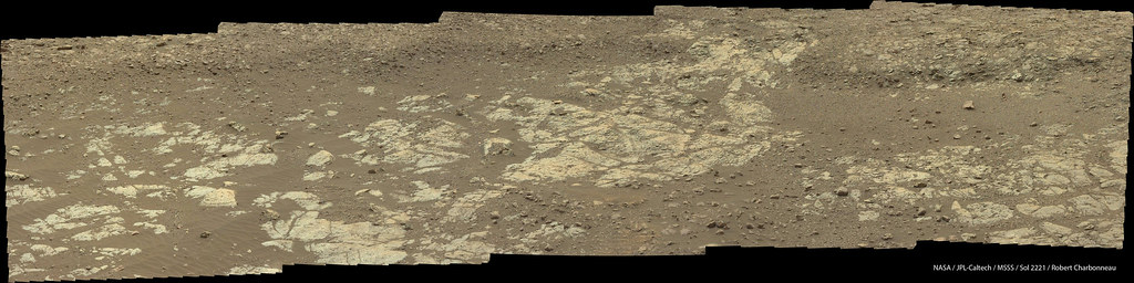
Sol 2222 Lmastcam view of the Highfield work area:
|
|
|
|
|
Nov 8 2018, 05:06 PM
Post
#561
|
|
|
Member Group: Members Posts: 684 Joined: 24-July 15 Member No.: 7619 |
QUOTE (serpens @ Nov 8 2018, 12:23 AM) To put this in perspective, imagine trying to explain coal deposits in Antarctica based on the current Antarctic environment. Hmm, just thinking about how the Chesapeake Bay crater determines the location of the mouth of the bay and determines the route of local rivers. It ALSO trapped a layer of brine under the surface water, so the hydrology is rather interesting... Given the elevation of Gale crater, and recent northern-ocean papers, is there any way to differentiate whether Gale was lacrustine or perhaps an interior estuary? QUOTE (serpens @ Nov 8 2018, 12:23 AM) mission update indicated that the Mojave gypsum crystals "grew at the interface between loose, water-logged sediment and either shallow water or air". Yet the physical aspects suggest traction sedimentation in deeper water. Hmm, reminds me of the Newark Basin paradox- a 2-mile deep deposit of shallow water mudstone interbedded with fanglomerates and sandstones. (It is a paradox because with a 2-mile deep basin [~about the average depth of the Atlantic or Pacific] you'd expect to start with deep water sediments which get shallower as you fill in the basin over time. Instead, the Newark basin was shallow during the entire time that 2 miles of sediment were deposited.) |
|
|
|
|
Nov 8 2018, 09:26 PM
Post
#562
|
|||
 Senior Member Group: Members Posts: 2425 Joined: 30-January 13 From: Penang, Malaysia. Member No.: 6853 |
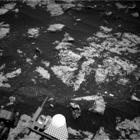
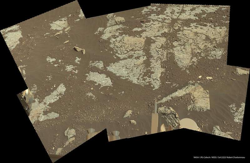
I think the team will be delighted to see this ring of drill cuttings around 'Highfield' shown in this R-NavCam frame from sol 2224
|
||
|
|
|
||
|
Nov 8 2018, 10:06 PM
Post
#563
|
||
|
Solar System Cartographer Group: Members Posts: 10145 Joined: 5-April 05 From: Canada Member No.: 227 |
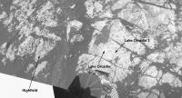
Yes! I hope it's enough.
Here is an illustration of the new site relative to the two previous drills at Lake Orcadie, sols 1977 and 1982. The image is a composite of pictures from sols 1962 and 2222. Phil
-------------------- ... because the Solar System ain't gonna map itself.
Also to be found posting similar content on https://mastodon.social/@PhilStooke NOTE: everything created by me which I post on UMSF is considered to be in the public domain (NOT CC, public domain) |
|
|
|
|
|
|
Nov 8 2018, 11:24 PM
Post
#564
|
||
|
Senior Member Group: Members Posts: 2425 Joined: 30-January 13 From: Penang, Malaysia. Member No.: 6853 |
Nice work Phil, I did not realise it was so close to the earlier attempts.
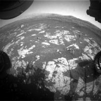
I guess all three are located within this HazCam image from sol 2224 
|
|
|
|
|
|
|
Nov 8 2018, 11:38 PM
Post
#565
|
|
|
Senior Member Group: Members Posts: 1043 Joined: 17-February 09 Member No.: 4605 |
QUOTE (HSchirmer @ Nov 8 2018, 05:06 PM) ...Given the elevation of Gale crater, and recent northern-ocean papers, is there any way to differentiate whether Gale was lacrustine or perhaps an interior estuary? ...the Newark Basin paradox... To avoid cluttering this thread with off topic comment I continued discussion on the geomorphology of Gale crater topic. |
|
|
|
|
Nov 9 2018, 08:27 AM
Post
#566
|
|
|
Senior Member Group: Members Posts: 2425 Joined: 30-January 13 From: Penang, Malaysia. Member No.: 6853 |
I have assembled a short video of the drilling at 'Highfield' using all of 41 FLA HazCam frames currently available YouTube Link
I reduced the image dimensions to 800x400 to speed up loading time (video run time ~7 seconds) drill time ~31 minutes Looks like it went deep enough, fingers crossed there is enough material in the drill sleeve, and for a successful transfer to CheMin and SAM in the coming days EDIT: Change link after the original to Reddit failed, the new one is to YouTube. |
|
|
|
|
Nov 9 2018, 03:41 PM
Post
#567
|
||
 Senior Member Group: Members Posts: 4246 Joined: 17-January 05 Member No.: 152 |
Picking up some gusts these sols. From 2215:
|
|
|
|
|
|
|
Nov 9 2018, 11:07 PM
Post
#568
|
||
|
Senior Member Group: Members Posts: 2425 Joined: 30-January 13 From: Penang, Malaysia. Member No.: 6853 |
QUOTE (fredk @ Nov 9 2018, 11:41 PM) Picking up some gusts these sols. From 2215: Nice catch More evidence of the wind in this animation of Highfield on sols 2224 and 2225
|
|
|
|
|
|
|
Nov 10 2018, 07:24 AM
Post
#569
|
|
|
Senior Member Group: Members Posts: 2425 Joined: 30-January 13 From: Penang, Malaysia. Member No.: 6853 |
Question for the members: Do we know how much of the A-side computer memory was marked bad after the sol 200 anomaly? I can't recall seeing it published. TIA
|
|
|
|
|
Nov 10 2018, 08:43 AM
Post
#570
|
||
|
Senior Member Group: Members Posts: 2425 Joined: 30-January 13 From: Penang, Malaysia. Member No.: 6853 |
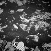
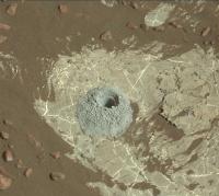
Just in:
Our first look at the sample hole at 'Highfield' in raw colour. R-MastCam, sol 2224. Hopefully this completes the full set of samples from the ridge and we can soon head into the Clay Trough
|
|
|
|
|
|
|

|
Lo-Fi Version | Time is now: 18th April 2024 - 08:47 AM |
|
RULES AND GUIDELINES Please read the Forum Rules and Guidelines before posting. IMAGE COPYRIGHT |
OPINIONS AND MODERATION Opinions expressed on UnmannedSpaceflight.com are those of the individual posters and do not necessarily reflect the opinions of UnmannedSpaceflight.com or The Planetary Society. The all-volunteer UnmannedSpaceflight.com moderation team is wholly independent of The Planetary Society. The Planetary Society has no influence over decisions made by the UnmannedSpaceflight.com moderators. |
SUPPORT THE FORUM Unmannedspaceflight.com is funded by the Planetary Society. Please consider supporting our work and many other projects by donating to the Society or becoming a member. |
|