InSight Surface Operations, 26 Nov 2018- 21 Dec 2022 |

  |
InSight Surface Operations, 26 Nov 2018- 21 Dec 2022 |
 Dec 13 2018, 01:10 AM Dec 13 2018, 01:10 AM
Post
#271
|
|
 Member  Group: Members Posts: 362 Joined: 12-June 05 From: Kiama, Australia Member No.: 409 |
QUOTE (nprev @ Dec 13 2018, 10:56 AM)  Thanks, Propguy.  Quick question re the WTS: How much is it expected to reduce the amount of temperature variation? I imagine that the soil covered by the WTS will provide some extra heat capacity that will stabilize the temp variation somewhat more than the air temperature |
 |
 
|
|
Dec 13 2018, 01:55 AM
Post
#272
|
|
|
Merciless Robot Group: Admin Posts: 8783 Joined: 8-December 05 From: Los Angeles Member No.: 602 |
Right, and the anchors on the seismometer will also stab down into the soil a bit to provide better surface bonding for signal detection, which will also help with temperature stabilization.
I suspect that the W is the primary purpose of WTS, not the T.
-------------------- A few will take this knowledge and use this power of a dream realized as a force for change, an impetus for further discovery to make less ancient dreams real.
|
|
|
|
|
Dec 13 2018, 02:02 AM
Post
#273
|
|
|
Founder Group: Chairman Posts: 14432 Joined: 8-February 04 Member No.: 1 |
This pdf -https://ttu-ir.tdl.org/ttu-ir/bitstream/handle/2346/59518/ICES-2014-64.pdf
Charts - especially on pages 14 and 15 - show the WTS, combined with a small heater on SEIS itself - makes quite a dramatic different to the temperature swings experiences by SEIS. |
|
|
|
|
Dec 13 2018, 02:25 AM
Post
#274
|
|||
|
Founder Group: Chairman Posts: 14432 Joined: 8-February 04 Member No.: 1 |
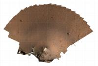
I've done a V2 of my workspace model, complete with WebVR scaling - https://sketchfab.com/models/038d4924308f4c...00fe492b1450997 - I think it's to approx the right scale - I used the width of the blue margin in this image - https://photojournal.jpl.nasa.gov/catalog/PIA22874 - as a guide ( as the blue margin represents the radius of the SEIS WTS I believe )
As a result - take these with a pinch of salt - but an orthoimage and a dem with a 50cm grid overlay, attached.
Attached thumbnail(s)
|
||
|
|
|
||
|
Dec 13 2018, 02:57 AM
Post
#275
|
|
|
Merciless Robot Group: Admin Posts: 8783 Joined: 8-December 05 From: Los Angeles Member No.: 602 |
Thanks for that thermal paper, Doug. Dramatic improvement indeed, and I was unaware of the heater. Count me as a WTS fan, emphasis on the T!
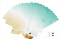
Re your DEM: The scale is cm for the elevation contours, right? Regardless, hard to ask for a flatter place than that. -------------------- A few will take this knowledge and use this power of a dream realized as a force for change, an impetus for further discovery to make less ancient dreams real.
|
|
|
|
|
Dec 13 2018, 05:47 AM
Post
#276
|
|
|
Founder Group: Chairman Posts: 14432 Joined: 8-February 04 Member No.: 1 |
The DEM scale is M, so about 15cm across the entire thing. Incredibly flat.
|
|
|
|
|
Dec 13 2018, 12:06 PM
Post
#277
|
|
 Member Group: Members Posts: 809 Joined: 3-June 04 From: Brittany, France Member No.: 79 |
Here is my take on the sol 14 panorama of the landing site. I prepare a version with a filled sky.

-------------------- |
|
|
|
|
Dec 13 2018, 12:21 PM
Post
#278
|
|
 Senior Member Group: Members Posts: 2428 Joined: 30-January 13 From: Penang, Malaysia. Member No.: 6853 |
Sol 16 IDC & ICC images have been downlinked to the server, so far 50 are posted
link |
|
|
|
|
Dec 13 2018, 05:21 PM
Post
#279
|
|
|
Member Group: Members Posts: 808 Joined: 10-October 06 From: Maynard Mass USA Member No.: 1241 |
-------------------- CLA CLL
|
|
|
|
|
Dec 13 2018, 05:36 PM
Post
#280
|
|
 Member Group: Members Posts: 112 Joined: 20-August 12 From: Spain Member No.: 6597 |
It's official, HiRISE image of the InSight hardware: https://www.uahirise.org/releases/insight/hardware/
|
|
|
|
|
Dec 13 2018, 05:38 PM
Post
#281
|
|
 Senior Member Group: Members Posts: 4246 Joined: 17-January 05 Member No.: 152 |
The orbital view shows blast effects out to roughly 20 metres or so from Insight. So Phil's circular post showing us at a "bull's eye" location is probably just due to the engines - there's nothing too unusual about the location.
|
|
|
|
|
Dec 15 2018, 01:30 PM
Post
#282
|
|
 Senior Member Group: Members Posts: 1729 Joined: 3-August 06 From: 43° 35' 53" N 1° 26' 35" E Member No.: 1004 |
raw images for Sol 18 are up. they seem to indicate that seismometer deployment is imminent
|
|
|
|
|
Dec 15 2018, 03:52 PM
Post
#283
|
||
 Member Group: Members Posts: 238 Joined: 15-January 13 Member No.: 6842 |
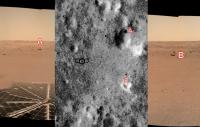
If I oriented myself correctly, I think I identified a few major boulders and craters visible in the sol14 panorama with what I see in the HiRISE images.
 (using Phil Stooke's image for inlay)
The low "ridge" is also visible behind the "A" boulder. -------------------- Curiosity rover panoramas: http://www.facebook.com/CuriosityRoverPanoramas
My Photosynth panoramas: http://photosynth.net/userprofilepage.aspx...;content=Synths |
|
|
|
|
|
|
Dec 15 2018, 05:03 PM
Post
#284
|
|||||
|
Senior Member Group: Members Posts: 4246 Joined: 17-January 05 Member No.: 152 |
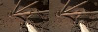
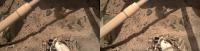
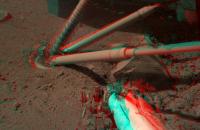
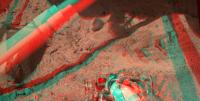
Sol 18 stereo views. Cross-eyed:
And anaglyphs:
There are uncorrected distortions here, so these may cause eyestrain... |
||||
|
|
|
||||
|
Dec 15 2018, 05:33 PM
Post
#285
|
||
|
Senior Member Group: Members Posts: 2920 Joined: 14-February 06 From: Very close to the Pyrénées Mountains (France) Member No.: 682 |
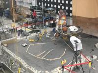
This tweeter feed from &MoonNext show how theyve reproduced InSights work place a-t-il JPL
Edit : be uploaded 4 Times and cant see it on my post to delete, sorry Fixed, and thanks! - Admin
Attached thumbnail(s)
-------------------- |
|
|
|
|
|
|

|
Lo-Fi Version | Time is now: 29th April 2024 - 09:25 AM |
|
RULES AND GUIDELINES Please read the Forum Rules and Guidelines before posting. IMAGE COPYRIGHT |
OPINIONS AND MODERATION Opinions expressed on UnmannedSpaceflight.com are those of the individual posters and do not necessarily reflect the opinions of UnmannedSpaceflight.com or The Planetary Society. The all-volunteer UnmannedSpaceflight.com moderation team is wholly independent of The Planetary Society. The Planetary Society has no influence over decisions made by the UnmannedSpaceflight.com moderators. |
SUPPORT THE FORUM Unmannedspaceflight.com is funded by the Planetary Society. Please consider supporting our work and many other projects by donating to the Society or becoming a member. |
|