Unmanned landing sites from LRO, Surveyors, Lunas, Lunakhods and impact craters from hardware impacts |

  |
Unmanned landing sites from LRO, Surveyors, Lunas, Lunakhods and impact craters from hardware impacts |
 Jun 1 2010, 01:00 AM Jun 1 2010, 01:00 AM
Post
#106
|
||
|
Solar System Cartographer  Group: Members Posts: 10145 Joined: 5-April 05 From: Canada Member No.: 227 |
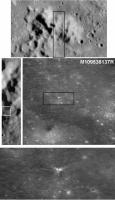
Another possible impact crater... this might be SMART-1. If so, it just skimmed the crest of the mountain in the top image (approaching from the north) and hit the surface slightly to the south of it. I don't know how plausible that is, but I don't see another candidate site yet.
Phil
-------------------- ... because the Solar System ain't gonna map itself.
Also to be found posting similar content on https://mastodon.social/@PhilStooke NOTE: everything created by me which I post on UMSF is considered to be in the public domain (NOT CC, public domain) |
|
 |
 
|
|
|
Jun 23 2010, 09:05 PM
Post
#107
|
||
|
Solar System Cartographer Group: Members Posts: 10145 Joined: 5-April 05 From: Canada Member No.: 227 |
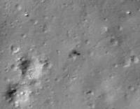
The new release is out... and to celebrate it, here's Surveyor 7 casting a nice shadow.
Phil
-------------------- ... because the Solar System ain't gonna map itself.
Also to be found posting similar content on https://mastodon.social/@PhilStooke NOTE: everything created by me which I post on UMSF is considered to be in the public domain (NOT CC, public domain) |
|
|
|
|
|
|
Jun 23 2010, 09:10 PM
Post
#108
|
||
|
Solar System Cartographer Group: Members Posts: 10145 Joined: 5-April 05 From: Canada Member No.: 227 |
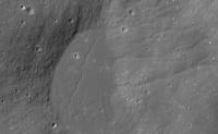
... and the nearby 'playa' which was the actual landing target. Nice gullies!
(the image number is in the filename if you save these images) Phil
-------------------- ... because the Solar System ain't gonna map itself.
Also to be found posting similar content on https://mastodon.social/@PhilStooke NOTE: everything created by me which I post on UMSF is considered to be in the public domain (NOT CC, public domain) |
|
|
|
|
|
|
Jun 24 2010, 12:35 PM
Post
#109
|
||
|
Solar System Cartographer Group: Members Posts: 10145 Joined: 5-April 05 From: Canada Member No.: 227 |
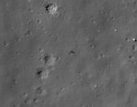
This is Surveyor 7 from the raw image instead of the zoomify screen.
Phil
-------------------- ... because the Solar System ain't gonna map itself.
Also to be found posting similar content on https://mastodon.social/@PhilStooke NOTE: everything created by me which I post on UMSF is considered to be in the public domain (NOT CC, public domain) |
|
|
|
|
|
|
Jun 24 2010, 02:34 PM
Post
#110
|
|
 Interplanetary Dumpster Diver Group: Admin Posts: 4404 Joined: 17-February 04 From: Powell, TN Member No.: 33 |
I have waited to see this for so long. WOW!
-------------------- |
|
|
|
|
Jun 24 2010, 03:11 PM
Post
#111
|
||
|
Solar System Cartographer Group: Members Posts: 10145 Joined: 5-April 05 From: Canada Member No.: 227 |
This is an extreme enlargement of the area around Surveyor 7 in that image, fitted to craters in the detailed site plan in my Atlas, and with Surveyor 7 placed in its correct location and orientation. The spacecraft drawing doesn't show the solar panel/antenna assembly to avoid hiding objects beneath it. Phil -------------------- ... because the Solar System ain't gonna map itself.
Also to be found posting similar content on https://mastodon.social/@PhilStooke NOTE: everything created by me which I post on UMSF is considered to be in the public domain (NOT CC, public domain) |
|
|
|
|
|
|
Jun 27 2010, 10:29 AM
Post
#112
|
|
 Member Group: Members Posts: 547 Joined: 1-May 06 From: Scotland (Ecosse, Escocia) Member No.: 759 |
How extremely nice ... I am just looking at your Atlas tome. Good fit, Phil !
|
|
|
|
|
Jun 27 2010, 11:10 AM
Post
#113
|
|
|
Solar System Cartographer Group: Members Posts: 10145 Joined: 5-April 05 From: Canada Member No.: 227 |
Thanks, Kenny!
Phil -------------------- ... because the Solar System ain't gonna map itself.
Also to be found posting similar content on https://mastodon.social/@PhilStooke NOTE: everything created by me which I post on UMSF is considered to be in the public domain (NOT CC, public domain) |
|
|
|
|
Jun 27 2010, 11:03 PM
Post
#114
|
|
|
Member Group: Members Posts: 315 Joined: 1-October 06 Member No.: 1206 |
Wow! Slightly OT, but is that a 'pond' of impact melt? And what are those 'knobs' near Surveyor?
P |
|
|
|
|
Jun 28 2010, 12:30 AM
Post
#115
|
|
|
Solar System Cartographer Group: Members Posts: 10145 Joined: 5-April 05 From: Canada Member No.: 227 |
Yes, it's one of many ponds of impact melt around Tycho. The pattern of cracks is quite typical. I'm not sure which knobs you're referring to, but probably what you are describing are just rocks. This was quite a rocky site, as you can see if you look at the Surveyor 7 panorama (Google will lead you to it).
Phil -------------------- ... because the Solar System ain't gonna map itself.
Also to be found posting similar content on https://mastodon.social/@PhilStooke NOTE: everything created by me which I post on UMSF is considered to be in the public domain (NOT CC, public domain) |
|
|
|
|
Oct 14 2010, 03:57 PM
Post
#116
|
||
|
Solar System Cartographer Group: Members Posts: 10145 Joined: 5-April 05 From: Canada Member No.: 227 |
Here's a nice recently released LROC image of the tracks of Lunokhod 2, where it crossed a faint depression that they called "unnoticed rille". The image number is in the file name.
Phil
-------------------- ... because the Solar System ain't gonna map itself.
Also to be found posting similar content on https://mastodon.social/@PhilStooke NOTE: everything created by me which I post on UMSF is considered to be in the public domain (NOT CC, public domain) |
|
|
|
|
|
|
Mar 31 2012, 03:05 PM
Post
#117
|
|
|
Member Group: Members Posts: 212 Joined: 19-July 05 Member No.: 442 |
Supposedly the LRO has imaged the Lunar 23 & 24 landing sites:
Motherboard: Soviet Moon Mystery Solved by NASA, 50 years later Rather sadly the images are not included in the linked article. |
|
|
|
|
Mar 31 2012, 03:37 PM
Post
#118
|
|
|
Senior Member Group: Members Posts: 1276 Joined: 25-November 04 Member No.: 114 |
|
|
|
|
|
Mar 31 2012, 04:08 PM
Post
#119
|
|
 Member Group: Members Posts: 495 Joined: 12-February 12 Member No.: 6336 |
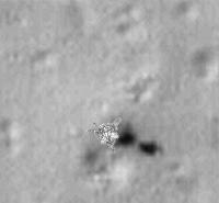
QUOTE (gndonald @ Mar 31 2012, 04:05 PM)  Supposedly the LRO has imaged the Lunar 23 & 24 landing sites: --- Rather sadly the images are not included in the linked article. Actually she do have images on her page also, click at below right of the image at 'next'. The one linked by Deception is uncropped so even better though.  |
|
|
|
|
Mar 31 2012, 04:31 PM
Post
#120
|
|
|
Solar System Cartographer Group: Members Posts: 10145 Joined: 5-April 05 From: Canada Member No.: 227 |
Luna 23 was an LPOD a few days ago. I have to say i'm not sure I can accept the new interpretation that the big white lump is the return capsule and the vehicle fell over. It transmitted to Earth for several days. The older interpretation from the first LROC images of it was that the lump was a rock which damaged the lander (i.e. it struck a glancing blow during landing). Seems more likely to me, but I suppose shadow analysis might help reveal the difference.
Phil -------------------- ... because the Solar System ain't gonna map itself.
Also to be found posting similar content on https://mastodon.social/@PhilStooke NOTE: everything created by me which I post on UMSF is considered to be in the public domain (NOT CC, public domain) |
|
|
|
|

|
Lo-Fi Version | Time is now: 18th April 2024 - 01:49 AM |
|
RULES AND GUIDELINES Please read the Forum Rules and Guidelines before posting. IMAGE COPYRIGHT |
OPINIONS AND MODERATION Opinions expressed on UnmannedSpaceflight.com are those of the individual posters and do not necessarily reflect the opinions of UnmannedSpaceflight.com or The Planetary Society. The all-volunteer UnmannedSpaceflight.com moderation team is wholly independent of The Planetary Society. The Planetary Society has no influence over decisions made by the UnmannedSpaceflight.com moderators. |
SUPPORT THE FORUM Unmannedspaceflight.com is funded by the Planetary Society. Please consider supporting our work and many other projects by donating to the Society or becoming a member. |
|