Chang'e-4 farside landing mission |

  |
Chang'e-4 farside landing mission |
 Feb 3 2019, 03:40 PM Feb 3 2019, 03:40 PM
Post
#181
|
|
 Junior Member  Group: Members Posts: 27 Joined: 15-January 08 Member No.: 4014 |
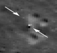
Here goes a new image taken from Yutu2. Apparently rover took it after driving few meters bit forward to NW.

-------------------- iss.astronet.pl
moonshot.astronet.pl |
 |
 
|
|
Feb 3 2019, 04:18 PM
Post
#182
|
|
|
Member Group: Members Posts: 149 Joined: 18-June 08 Member No.: 4216 |
The tip of that vertically-erected antenna is sitting some 7m above the surface (say 5m for the antenna, 2m for the lander deck). Would that constitute the tallest
articifial structure on the Moon at the moment? |
|
|
|
|
Feb 3 2019, 06:25 PM
Post
#183
|
|
|
Solar System Cartographer Group: Members Posts: 10153 Joined: 5-April 05 From: Canada Member No.: 227 |
Yes, I think it would be the highest structure.
The picture is newly released, and might be newly transmitted, but it was taken before sunset on the previous lunar day (based on the direction of the shadow). I have not seen any pictures or evidence of driving on this second lunar day. Phil -------------------- ... because the Solar System ain't gonna map itself.
Also to be found posting similar content on https://mastodon.social/@PhilStooke Maps for download (free PD: https://upload.wikimedia.org/wikipedia/comm...Cartography.pdf NOTE: everything created by me which I post on UMSF is considered to be in the public domain (NOT CC, public domain) |
|
|
|
|
Feb 3 2019, 10:18 PM
Post
#184
|
|
 Member Group: Members Posts: 290 Joined: 29-December 05 From: Ottawa, ON Member No.: 624 |
What spectacular scenery! Will the cameras on the lander have survived the lunar night? I believe that on Chang'e 3 the colour cameras were not protected and did not function afterwards.
|
|
|
|
|
Feb 5 2019, 09:39 AM
Post
#185
|
|
|
Junior Member Group: Members Posts: 27 Joined: 15-January 08 Member No.: 4014 |
Newly released image (from first "sol") taken by Yutu2 shortly after deployment onto lunar surface.
 -------------------- iss.astronet.pl
moonshot.astronet.pl |
|
|
|
|
Feb 6 2019, 06:28 PM
Post
#186
|
|
|
Solar System Cartographer Group: Members Posts: 10153 Joined: 5-April 05 From: Canada Member No.: 227 |
http://www.9ifly.cn/forum.php?mod=viewthre...ra=&page=89
This link is to the 9ifly forum, where a user has posted a map of Von Karman showing names "approved by the IAU" (the IAU planetary nomenclature site at USGS does not show it but they may not have updated yet, perhaps due to shutdown issues). Three craters around the landing site take names from the 'summer triangle' of bright stars, Vega, Altair, Deneb but using their Chinese names. The landing site is Statio Tianhe, where Tianhe means Milky Way. The names refer to the story of the Weaver and the Cowherd, lovers separated by the Milky Way and allowed to meet by crossing on a bridge formed of magpies, the same story from which the relay satellite gets its name. Finally the central peak is named Mons Tai after Taishan, a mountain in China. Phil -------------------- ... because the Solar System ain't gonna map itself.
Also to be found posting similar content on https://mastodon.social/@PhilStooke Maps for download (free PD: https://upload.wikimedia.org/wikipedia/comm...Cartography.pdf NOTE: everything created by me which I post on UMSF is considered to be in the public domain (NOT CC, public domain) |
|
|
|
|
Feb 6 2019, 06:31 PM
Post
#187
|
|
 Senior Member Group: Moderator Posts: 3233 Joined: 11-February 04 From: Tucson, AZ Member No.: 23 |
-------------------- &@^^!% Jim! I'm a geologist, not a physicist!
The Gish Bar Times - A Blog all about Jupiter's Moon Io |
|
|
|
|
Feb 6 2019, 07:20 PM
Post
#188
|
|
|
Solar System Cartographer Group: Members Posts: 10153 Joined: 5-April 05 From: Canada Member No.: 227 |
Spectacular, but I would hope a vertical view was obtained on a later orbit!
Phil -------------------- ... because the Solar System ain't gonna map itself.
Also to be found posting similar content on https://mastodon.social/@PhilStooke Maps for download (free PD: https://upload.wikimedia.org/wikipedia/comm...Cartography.pdf NOTE: everything created by me which I post on UMSF is considered to be in the public domain (NOT CC, public domain) |
|
|
|
|
Feb 9 2019, 07:05 AM
Post
#189
|
||
|
Solar System Cartographer Group: Members Posts: 10153 Joined: 5-April 05 From: Canada Member No.: 227 |
Well, a few orbits later but still the same day, a less oblique view:
http://lroc.sese.asu.edu/posts/1091 Lander and rover both visible, just. A vertical view on the next day is probably still to be released. Here is a modified view of the landing site:
-------------------- ... because the Solar System ain't gonna map itself.
Also to be found posting similar content on https://mastodon.social/@PhilStooke Maps for download (free PD: https://upload.wikimedia.org/wikipedia/comm...Cartography.pdf NOTE: everything created by me which I post on UMSF is considered to be in the public domain (NOT CC, public domain) |
|
|
|
|
|
|
Feb 11 2019, 06:22 AM
Post
#190
|
|
|
Junior Member Group: Members Posts: 27 Joined: 15-January 08 Member No.: 4014 |
It's a pity there is no information about second lunar day on the surface. I wonder if the mission is in any trouble and therefore chinese officials don't want to give any further details about the encountered problems...
-------------------- iss.astronet.pl
moonshot.astronet.pl |
|
|
|
|
Feb 11 2019, 07:28 AM
Post
#191
|
|
|
Solar System Cartographer Group: Members Posts: 10153 Joined: 5-April 05 From: Canada Member No.: 227 |
We have information about the first few (Earth) days of the second lunar day as shown on the map. Since then there has been a big holiday period coinciding with New Year in China, and many government offices etc. will have been closed. We might learn more this week. But no reason to expect a problem at this point. Also, a COSPAR meeting coming up where news may be released.
Phil -------------------- ... because the Solar System ain't gonna map itself.
Also to be found posting similar content on https://mastodon.social/@PhilStooke Maps for download (free PD: https://upload.wikimedia.org/wikipedia/comm...Cartography.pdf NOTE: everything created by me which I post on UMSF is considered to be in the public domain (NOT CC, public domain) |
|
|
|
|
Feb 15 2019, 06:05 AM
Post
#192
|
|
 Senior Member Group: Members Posts: 1729 Joined: 3-August 06 From: 43° 35' 53" N 1° 26' 35" E Member No.: 1004 |
|
|
|
|
|
Feb 15 2019, 10:19 PM
Post
#193
|
|
|
Newbie Group: Members Posts: 10 Joined: 26-November 18 From: Billericay, England Member No.: 8485 |
|
|
|
|
|
Feb 20 2019, 07:58 AM
Post
#194
|
|
|
Junior Member Group: Members Posts: 27 Joined: 15-January 08 Member No.: 4014 |
Hi,
Any further information about CH-4 mission status? Some chinese forum? This continuing lack of info is very disturbing. I wonder if something went wrong and chinese mission's directors don't want to publish it online untill resolution is found... -------------------- iss.astronet.pl
moonshot.astronet.pl |
|
|
|
|
Feb 20 2019, 08:31 AM
Post
#195
|
|
|
Senior Member Group: Members Posts: 1729 Joined: 3-August 06 From: 43° 35' 53" N 1° 26' 35" E Member No.: 1004 |
QUOTE (Station @ Feb 20 2019, 08:58 AM)  Any further information about CH-4 mission status? there was a very nice full moon this night, which means that it's night on the farside and CE4 and Yutu are sleeping peacefully |
|
|
|
|

|
Lo-Fi Version | Time is now: 28th April 2024 - 05:46 PM |
|
RULES AND GUIDELINES Please read the Forum Rules and Guidelines before posting. IMAGE COPYRIGHT |
OPINIONS AND MODERATION Opinions expressed on UnmannedSpaceflight.com are those of the individual posters and do not necessarily reflect the opinions of UnmannedSpaceflight.com or The Planetary Society. The all-volunteer UnmannedSpaceflight.com moderation team is wholly independent of The Planetary Society. The Planetary Society has no influence over decisions made by the UnmannedSpaceflight.com moderators. |
SUPPORT THE FORUM Unmannedspaceflight.com is funded by the Planetary Society. Please consider supporting our work and many other projects by donating to the Society or becoming a member. |
|