
Need help resizing USGS map of moon, Clementine/Lunar Orbiter |

Need help resizing USGS map of moon, Clementine/Lunar Orbiter |
 Jan 8 2021, 06:39 AM Jan 8 2021, 06:39 AM
Post
#1
|
|
 Member  Group: Members Posts: 226 Joined: 13-October 09 From: Olympus Mons Member No.: 4972 |
Hello,
I am trying to find maps of the moon that have the least possible amount of shadows in them. The best I can find is the Clementine map but unfortunately, there are many data gaps in it. The LRO WAC and Kaguya maps on the USGS site have a lot of shadows on them. However, there is a map that combines Clementine and Lunar Orbiter data but the problem is, my computer cannot even render this monster!!! https://astrogeology.usgs.gov/search/map/Mo...saic_Global_59m If someone with a more powerful computer could please help me get a version of this image that is 16384x8192 pixels, that would be great! I don't have access to Map a Planet to be able to get it. -------------------- "Thats no moon... IT'S A TRAP!"
|
 |
 
|
 |
|
Jan 14 2021, 08:49 PM
Post
#2
|
|
|
Member Group: Members Posts: 156 Joined: 22-May 09 From: Ireland Member No.: 4792 |
Have you tried in using the DEM options in LTVT, where it is possible to show such features from any sun angle -- on the horizon or directly overhead (below,
shows Aristoteles and Eudoxes under various lighting conditions - west and east, while the second image is that of the South Pole). John 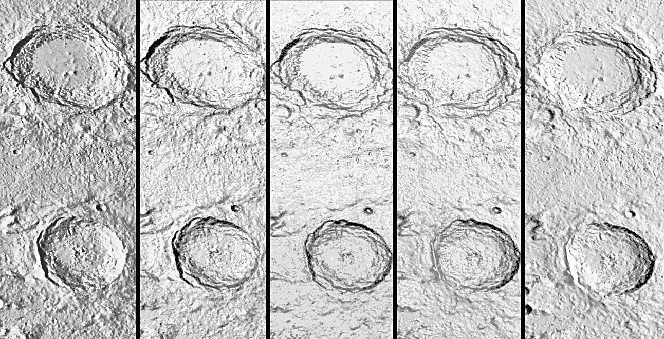 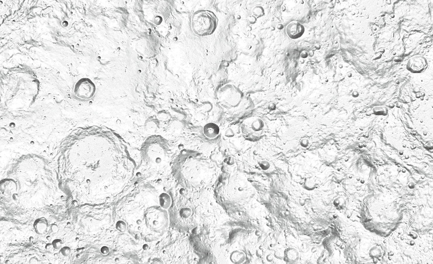
|
|
|
|
|
Feb 24 2021, 02:35 PM
Post
#3
|
|
 Newbie Group: Members Posts: 8 Joined: 21-February 21 Member No.: 8960 |
For bigtiff sattelite images you need to use GDAL. You do not need a powerful computer to process large data.
Here is the gdal command you need to use: https://gdal.org/programs/gdal_translate.ht...anslate-outsize CODE gdal_translate.py -outsize 16384 8192 Lunar_LO_UVVISv2_Hybrid_Mosaic_Global_59m.tif Lunar_LO_UVVISv2_Hybrid_Mosaic_Global_59m_downsampled.tif Or alternatively, if you'd prefer a graphical interface and/or you work with geodata regularly, i'd recommend using QGIS. Edit: I had not realized this was an old thread, sorry |
|
|
|
 Antdoghalo Need help resizing USGS map of moon Jan 8 2021, 06:39 AM
 mcaplinger QUOTE (Antdoghalo @ Jan 7 2021, 10:39 PM)... Jan 8 2021, 04:55 PM
 threadworm China has a whole moon image available from Chang... Jan 8 2021, 06:07 PM Antdoghalo QUOTE (mcaplinger @ Jan 8 2021, 11:55 AM)... Jan 8 2021, 06:22 PM mcaplinger QUOTE (Antdoghalo @ Jan 8 2021, 10:22 AM)... Jan 8 2021, 06:55 PM Antdoghalo Yeah, Like Mercury, the moon doesn't like expo... Jan 8 2021, 08:39 PM JRehling For half the product that you're looking for, ... Jan 9 2021, 10:45 AM Phil Stooke Use the LOLA shaded relief map to get topography i... Jan 9 2021, 07:54 AM Sean Here 'tis...
16384x8192 on WeTransfer
link i... Jan 9 2021, 06:37 PM Antdoghalo Thanks! It looks really cool close up with the... Jan 9 2021, 07:16 PM bkellysky For what it's worth, I like the Unified Geolog... Jan 13 2021, 01:39 AM
threadworm China has a whole moon image available from Chang... Jan 8 2021, 06:07 PM Antdoghalo QUOTE (mcaplinger @ Jan 8 2021, 11:55 AM)... Jan 8 2021, 06:22 PM mcaplinger QUOTE (Antdoghalo @ Jan 8 2021, 10:22 AM)... Jan 8 2021, 06:55 PM Antdoghalo Yeah, Like Mercury, the moon doesn't like expo... Jan 8 2021, 08:39 PM JRehling For half the product that you're looking for, ... Jan 9 2021, 10:45 AM Phil Stooke Use the LOLA shaded relief map to get topography i... Jan 9 2021, 07:54 AM Sean Here 'tis...
16384x8192 on WeTransfer
link i... Jan 9 2021, 06:37 PM Antdoghalo Thanks! It looks really cool close up with the... Jan 9 2021, 07:16 PM bkellysky For what it's worth, I like the Unified Geolog... Jan 13 2021, 01:39 AM |

|
Lo-Fi Version | Time is now: 1st May 2024 - 12:35 PM |
|
RULES AND GUIDELINES Please read the Forum Rules and Guidelines before posting. IMAGE COPYRIGHT |
OPINIONS AND MODERATION Opinions expressed on UnmannedSpaceflight.com are those of the individual posters and do not necessarily reflect the opinions of UnmannedSpaceflight.com or The Planetary Society. The all-volunteer UnmannedSpaceflight.com moderation team is wholly independent of The Planetary Society. The Planetary Society has no influence over decisions made by the UnmannedSpaceflight.com moderators. |
SUPPORT THE FORUM Unmannedspaceflight.com is funded by the Planetary Society. Please consider supporting our work and many other projects by donating to the Society or becoming a member. |
|


