Chandrayaan 1, India's First Lunar Probe |

  |
Chandrayaan 1, India's First Lunar Probe |
 Dec 15 2010, 05:19 PM Dec 15 2010, 05:19 PM
Post
#466
|
|
 Junior Member  Group: Members Posts: 21 Joined: 23-December 08 From: Mumbai Member No.: 4513 |
QUOTE (Nirgal @ Dec 12 2010, 09:40 PM)  Thanks for the update, Pradeep ! do you have any information when the first data from the Terrain Mapping Camera (TMC) which I am particularly looking forward to  will be released ? will be released ?there is a preview of TMC data published at the ISRO site (link) which looks very very promising (the announced 5-meter-per-pixel near-global DEM would be by far the best topographic map of the moon yet with resolution two times higher than SELENE/KAGUYA DTM and more than ten times higher than LOLA DTM ... No idea so far on a data release date. Pradeep -------------------- Pradeep Mohandas,
SEDS India. |
 |
 
|
|
Dec 15 2010, 06:29 PM
Post
#467
|
|
 Senior Member Group: Members Posts: 1729 Joined: 3-August 06 From: 43° 35' 53" N 1° 26' 35" E Member No.: 1004 |
by the way, there is yet another Chandrayaan-related paper on arXiv today
Extremely high reflection of solar wind protons as neutral hydrogen atoms from regolith in space |
|
|
|
|
Dec 27 2010, 03:07 PM
Post
#468
|
|
|
Member Group: Members Posts: 713 Joined: 30-March 05 Member No.: 223 |
This news article sounds interesting:
QUOTE (Pradeep @ Dec 15 2010, 06:19 PM) ISRO has stated recently, that the voluminous data gathered by Chandrayaan-I would be made available to the public by the end of the year 2010. The data would be eventually split into two seasons with the first season going public by the end of 2010 and the second going public by the mid of 2011. The data would contain rare pictures of the moon and also data from the chemical and mineral mapping of the lunar surface. Anyone more details on this upcoming end-of-2010 public data release ? |
|
|
|
|
Mar 1 2011, 09:36 PM
Post
#469
|
|
 Administrator Group: Admin Posts: 5172 Joined: 4-August 05 From: Pasadena, CA, USA, Earth Member No.: 454 |
Here it is:
http://www.issdc.gov.in/CHBrowse/index.jsp I've checked it out and currently there's only browse versions of the data available, and those at pretty high JPEG compression, but it's enough to have some 3D fun with. Remember that TMC, like HRSC, did simultaneous stereo, so every spot it imaged on the Moon can be seen in 3D with minimal effort. -------------------- My website - My Patreon - @elakdawalla on Twitter - Please support unmannedspaceflight.com by donating here.
|
|
|
|
|
Mar 2 2011, 10:14 PM
Post
#470
|
|
|
Member Group: Members Posts: 713 Joined: 30-March 05 Member No.: 223 |
QUOTE (elakdawalla @ Mar 1 2011, 10:36 PM) Here it is: Thanks a lot for the update, Emily ! I've been waiting for a long time for this one (Still courious about the Kaguya Terrain Camera data though which is still not (or only partially) released to date) |
|
|
|
|
Apr 15 2012, 08:20 PM
Post
#471
|
|
|
Member Group: Members Posts: 311 Joined: 31-August 05 From: Florida & Texas, USA Member No.: 482 |
Interesting research from LRO & Chandrayaan-1: evidence that volcanism has occured as recently as 100 million years ago in Tycho crater.
http://www.universetoday.com/94583/scienti...unar-volcanism/ http://www.deccanherald.com/content/241966...c-activity.html |
|
|
|
|
Apr 15 2012, 09:34 PM
Post
#472
|
|
|
Solar System Cartographer Group: Members Posts: 10160 Joined: 5-April 05 From: Canada Member No.: 227 |
Most observers seem to feel that the apparent volcanism is really impact melt. But we will have to see what other studies show.
Phil -------------------- ... because the Solar System ain't gonna map itself.
Also to be found posting similar content on https://mastodon.social/@PhilStooke Maps for download (free PD: https://upload.wikimedia.org/wikipedia/comm...Cartography.pdf NOTE: everything created by me which I post on UMSF is considered to be in the public domain (NOT CC, public domain) |
|
|
|
|
Sep 22 2019, 03:02 PM
Post
#473
|
|||
|
Solar System Cartographer Group: Members Posts: 10160 Joined: 5-April 05 From: Canada Member No.: 227 |
I will post this here despite the fact that it refers to Chandrayaan 1 rather than Chandrayaan 2, because the C-1 thread had not been added to since 2012.
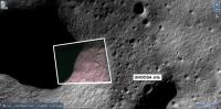
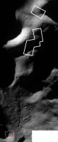
Over on the NASASpaceflight forum, user Astro-Neel posted this: https://forum.nasaspaceflight.com/index.php...2673#msg1992673 Astro-Neel posted some very useful video and other links, including one showing a descent video from MIP on Chandrayaan 1. The descent frames cover the last few minutes of MIP's descent, from over Malapert crater to a final image near the south pole. Note that we don't know that the last frame shown is the last frame taken (or received). I had suggested that it might lead to an improved estimate of the MIP impact point. There are two published locations for the impact, the most authoritative being the one in ISRO's report to UNOOSA after the impact, which Astro-Neel also linked to later: http://www.unoosa.org/documents/pdf/ser570E.pdf (note that the comment in that report about a name for the impact site being accepted by the IAU is not correct - it remains an informal name). I have located the last image in the video (below). It is on the rim of a small crater about 7 by 10 km across, and about 1.5 km north of the UNOOSA impact coordinates. The shape of the image outline suggests it was taken slightly obliquely from a position north of the image center, not too far north but maybe over its northern edge. (NORTH is to the left, approximately).
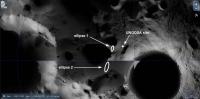
The second image (below) shows a predicted impact location. MIP may have struck the surface on the wall of that crater in ellipse 1, or it may have flown above that crater rim and hit the surface on the rim of the next crater in ellipse 2 on my image. If it passed over that crater rim it would have hit the earth-facing slope of the 'connecting ridge' between the rims of the two large craters (De Gerlache and Shackleton).
Let the splat-hunting begin! Phil -------------------- ... because the Solar System ain't gonna map itself.
Also to be found posting similar content on https://mastodon.social/@PhilStooke Maps for download (free PD: https://upload.wikimedia.org/wikipedia/comm...Cartography.pdf NOTE: everything created by me which I post on UMSF is considered to be in the public domain (NOT CC, public domain) |
||
|
|
|
||
|
Sep 22 2019, 09:12 PM
Post
#474
|
|
|
Member Group: Members Posts: 156 Joined: 22-May 09 From: Ireland Member No.: 4792 |
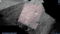
Just a 3d perspective of the area...such views sometimes give a good perspective to how the terrain roughly lies.
John 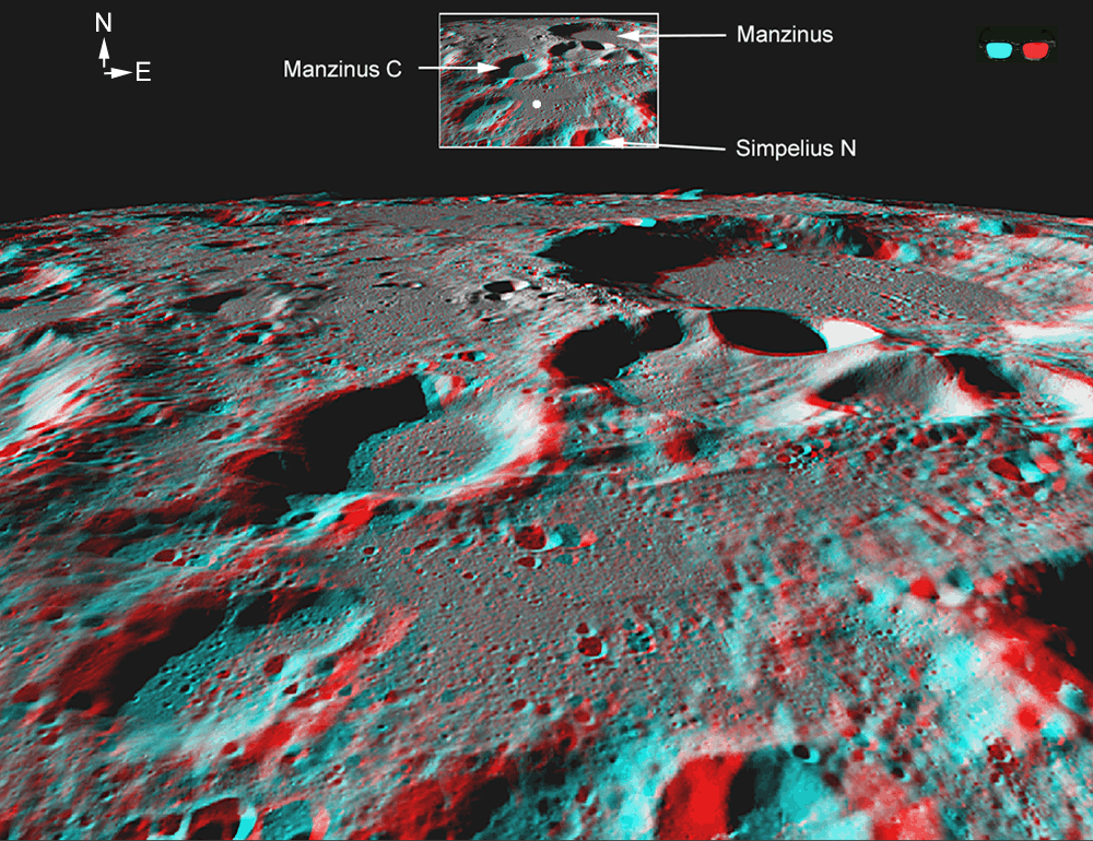
|
|
|
|
|
Sep 23 2019, 02:30 AM
Post
#475
|
|||
|
Member Group: Members Posts: 103 Joined: 12-September 19 Member No.: 8664 |
QUOTE (Phil Stooke @ Sep 22 2019, 08:32 PM) I will post this here despite the fact that it refers to Chandrayaan 1 rather than Chandrayaan 2, because the C-1 thread had not been added to since 2012. <snip> Let the splat-hunting begin! Phil That is one blast from past, amazing work. Just to point out that MIP footage is from a presentation by Alok Srivastava given at IISc that I have re-hosted, unfortunately it is in Hindi but if anyone wants translation of any relevant part just ask! https://youtu.be/18A2araj9XE?t=2415 It was long time ago but I think there are more frames from MIP. Let me add those links here as well. https://imgur.com/a/i6G9fI7 QUOTE MIP carried three instruments viz. Radar altimeter, Mass Spectrometer and Moon Imaging system (MIS) and operated during the descent to the Moon and **imaged the lunar surface in a total of 3110 frames**. Some other references on Chandrayaan-1 imagery featuring MIS frames. * Selected Images from Chandrayaan-1 of Moon (~388 mb) PDF / Archive (See page 117) * Chandrayaan-1 Lunar Science Atlas (~70 mb) PDF / Archive (See page 93) Source: https://vedas.sac.gov.in/vedas/node/63 Mirroring both for easier online viewing: https://archive.org/details/Chandrayaan-1_Atlas Edit: Fixed links and attached frame 3105
Attached thumbnail(s)
|
||
|
|
|
||
|
Sep 23 2019, 09:15 AM
Post
#476
|
||
|
Solar System Cartographer Group: Members Posts: 10160 Joined: 5-April 05 From: Canada Member No.: 227 |
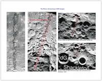
Thanks! Here is an image showing locations of some of the last frames:
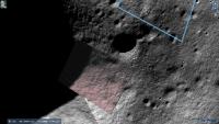
When I compare this with the last image you posted showing a predicted impact point, my locations seem to run along the right edge of the image 'corridor' rather than its center. Those previous attempts to locate the last images were plotted on an Earth-based radar image (the other image base is from Clementine), and I am using LRO NAC images with at least 20 times the resolution (probably better than that), where images can be located with much better accuracy (I'm not talking about the base image in my post which is lower resolution). Note that the posted image says the circle is 1 km diameter, but it is actually 10 km (Shackleton is 20 km across). Maybe this should all be moved to a new thread... Phil -------------------- ... because the Solar System ain't gonna map itself.
Also to be found posting similar content on https://mastodon.social/@PhilStooke Maps for download (free PD: https://upload.wikimedia.org/wikipedia/comm...Cartography.pdf NOTE: everything created by me which I post on UMSF is considered to be in the public domain (NOT CC, public domain) |
|
|
|
|
|
|
Sep 23 2019, 02:53 PM
Post
#477
|
||||
|
Member Group: Members Posts: 103 Joined: 12-September 19 Member No.: 8664 |
QUOTE (Phil Stooke @ Sep 23 2019, 02:45 PM) Thanks! Here is an image showing locations of some of the last frames:
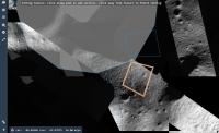
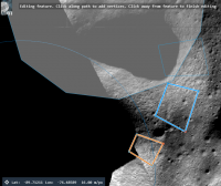
When I compare this with the last image you posted showing a predicted impact point, my locations seem to run along the right edge of the image 'corridor' rather than its center. Those previous attempts to locate the last images were plotted on an Earth-based radar image (the other image base is from Clementine), and I am using LRO NAC images with at least 20 times the resolution (probably better than that), where images can be located with much better accuracy (I'm not talking about the base image in my post which is lower resolution). Note that the posted image says the circle is 1 km diameter, but it is actually 10 km (Shackleton is 20 km across). Maybe this should all be moved to a new thread... Phil Another thread or an old relevant one would be nice. I have matched frame 3102 with LRO NAC reference image... getting closer but need to keep in mind 49° off nadir angle of imaging. Here's Quickmap link outlining frame 3102 and last frame from video.
Attached thumbnail(s)
|
|||
|
|
|
|||
|
Sep 23 2019, 04:01 PM
Post
#478
|
|
|
Member Group: Members Posts: 103 Joined: 12-September 19 Member No.: 8664 |
|
|
|
|
|
Sep 23 2019, 07:36 PM
Post
#479
|
|
|
Solar System Cartographer Group: Members Posts: 10160 Joined: 5-April 05 From: Canada Member No.: 227 |
This is excellent. We are seeing that the impact point is further along the trajectory that the 'official' estimate in the UN document. It may be possible to find a plausible impact feature along this trajectory.
Phil -------------------- ... because the Solar System ain't gonna map itself.
Also to be found posting similar content on https://mastodon.social/@PhilStooke Maps for download (free PD: https://upload.wikimedia.org/wikipedia/comm...Cartography.pdf NOTE: everything created by me which I post on UMSF is considered to be in the public domain (NOT CC, public domain) |
|
|
|
|
Sep 23 2019, 07:52 PM
Post
#480
|
|
|
Member Group: Members Posts: 103 Joined: 12-September 19 Member No.: 8664 |
Indeed if 3110 frames are captured and we are already out of previous 'corridor' then impact point could easily be within ellipse 2. I had to stop as I couldn't find more well lit NAC images near relevant area and I see few requests for LRO team are already there
http://target.lroc.asu.edu/output/lroc/lroc_page.html |
|
|
|
|

|
Lo-Fi Version | Time is now: 13th May 2024 - 05:33 AM |
|
RULES AND GUIDELINES Please read the Forum Rules and Guidelines before posting. IMAGE COPYRIGHT |
OPINIONS AND MODERATION Opinions expressed on UnmannedSpaceflight.com are those of the individual posters and do not necessarily reflect the opinions of UnmannedSpaceflight.com or The Planetary Society. The all-volunteer UnmannedSpaceflight.com moderation team is wholly independent of The Planetary Society. The Planetary Society has no influence over decisions made by the UnmannedSpaceflight.com moderators. |
SUPPORT THE FORUM Unmannedspaceflight.com is funded by the Planetary Society. Please consider supporting our work and many other projects by donating to the Society or becoming a member. |
|