Printable Version of Topic
Click here to view this topic in its original format
Unmanned Spaceflight.com _ Cassini's ongoing mission and raw images _ Rev 49 - Aug 9-Sep 14, 2007 - Iapetus I1
Posted by: elakdawalla Sep 7 2007, 05:46 PM
[Moderator's note: This thread contains images from the Iapetus 2007-09-10 flyby and discussion of them. It was created by splitting http://www.unmannedspaceflight.com/index.php?showtopic=3782 which contains pre-flyby discussion]
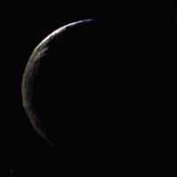
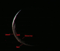
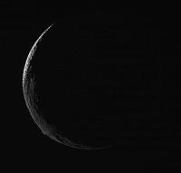
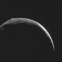
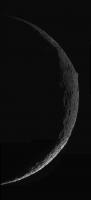
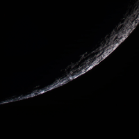
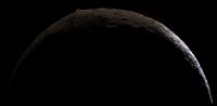
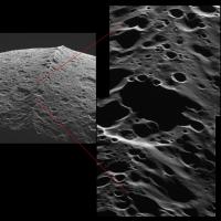
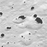
Another CL-UV3-GRN-IR1 set was posted today, though Iapetus seems to have been hiding from the green and IR filters...here's my best effort at making something from the CL and UV3 images. Lots of topography on the limb!
--Emily
|
Posted by: AlexBlackwell Sep 7 2007, 05:48 PM

TED!!!!!! Should I or shouldn't I??

Posted by: ugordan Sep 7 2007, 05:48 PM
I actually like the color in this one best. The stretched color views tend to oversaturate Cassini Regio.
Here's a quick collage of some of the lowest and some of the highest resolution color imagery we got of Iapetus in the past 3 years:
http://img209.imageshack.us/my.php?image=iapetustw3.jpg
To think that in less than 4 days we'll have images with resolutions up to 1000 times better than the best shown here is exciting to say the least.
Posted by: volcanopele Sep 8 2007, 07:32 AM
ISS_049IA_IAPETUS002_CIRS is now on the ground:
Clear Filter Frame: http://saturn.jpl.nasa.gov/multimedia/images/raw/raw-images-details.cfm?feiImageID=125907
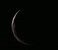
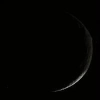
This was supposed to include a true color filter set (BL1, GRN, and RED), but it looks like the shutter times were a tad off and the RED and IR2 images were taken after CIRS pointed away from Iapetus (it points away from its target at the start and end of observations for calibration purposes). However, there is a UV3-GRN-IR1 filter set available from some industrious individual. The auto stretch feature appears to be working now so you guys should be able to do something with this data set.
Some interesting topography is visible in the crescent seen here, including the impact basin in south-central Cassini Regio, a pair of ridges to the northwest of the impact basin in north-central Cassini Regio (these things need names!!), and the equatorial ridge.
You know what, that's it, I am instituting a system of nicknames for the impact basins on Iapetus. These are just nicknames. In keeping with the official naming scheme for Iapetus, characters and places from the Song of Roland, all the nicknames will be predominately French. Map upcoming.
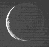
Posted by: CAP-Team Sep 8 2007, 08:45 AM
Here's an IR3/GRN/BLU combination image from 7 september:
|
Posted by: volcanopele Sep 8 2007, 09:13 AM
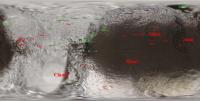
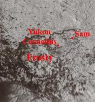
Here is a map of official names (in green) and nicknames (in red):
|
Posted by: TritonAntares Sep 8 2007, 10:39 AM
|
Frosty, Sam, Yukon, Cornellis - doesn't sound french at all...

Anxious about calling the whole crater triplet Snowman - or say better in french:
bonhomme de neige...

I think IAU will get in trouble creating names from 'The Song of Roland', simply because of a limited number of characters there!
Nomenclatura in french seems to be one solution.
I personally would prefer naming surface structures after their appearance, like the Snowman for instance.
Bye.
Posted by: scalbers Sep 8 2007, 02:05 PM
Nice to have CAP-Team's image and VP's names for reference. I think I can see Lionel on the terminator of the 9/7 image and maybe Jeanne near the limb. The NNE edge of Henri may be a spot where the bellyband diminishes eastward (into a flat area) and we thus would be seeing a shadowed slope along the bellyband in the image. If we can make out as far as the SW edge of Henri that could fill in a blank sliver on the map.
|
I'll go ahead and opine that we might eventually want a "Claudette" just to the east of "Claude"
Posted by: CAP-Team Sep 8 2007, 04:00 PM
this is a simulated view, using VP's map with nicknames in Xplanet:
|
Posted by: tasp Sep 8 2007, 04:52 PM
May I propose refering to the large elongated crater S of Joan on the edge of Casini Regio as Papillion ??
thanx for the consideration
Posted by: volcanopele Sep 8 2007, 04:59 PM
|
|
Frosty, Sam, Yukon, Cornellis - doesn't sound french at all...
Anxious about calling the whole crater triplet Snowman - or say better in french:
bonhomme de neige...
Nomenclatura in french seems to be one solution.
I personally would prefer naming surface structures after their appearance, like the Snowman for instance.
Posted by: Decepticon Sep 8 2007, 07:03 PM
ugordan Your image is amazing! I appreciate the effort to make that montage. 
Posted by: Decepticon Sep 9 2007, 04:43 AM
Great News! New pics!
WOW! http://saturn1.jpl.nasa.gov/multimedia/images/raw/casJPGFullS33/N00091644.jpg
My sad attempt at stacking. 
|
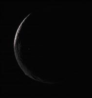
Posted by: elakdawalla Sep 9 2007, 05:24 AM
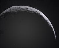
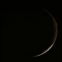
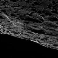
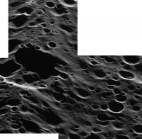
Great stuff! Sadly the sole long-wavelength image seems to have missed, so I had to fudge for the red channel. The version below consists of clear for red, a stack of four green images for the green (clear plus 3 polarizers), and, for blue, the UV3 channel with cosmic ray hits erased or corrected for by copying bits from the polarized channels where cosmic rays hit the sunlit part of Iapetus. Then I converted to Lab, replaced the lightness with the clear image, and went back to RGB.
|
That's some pretty rumply looking topography in the southern hemisphere basin! The "belly band" seems to look sorta segmented, with little north-south notches cut into it.
--Emily
Posted by: volcanopele Sep 9 2007, 05:58 AM
The South-central Cassini Regio impact basin ("Henri") appears to have a central massif, which matches with the morphology of similar basins in north-central Cassini Regio ("Aimee") and northeastern Cassini Regio ("Joan").
Not sure what is up with the equatorial ridge.
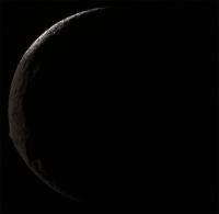
Posted by: Bjorn Jonsson Sep 9 2007, 03:56 PM
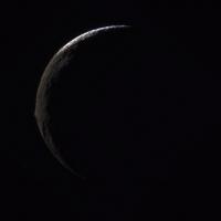
I tried stacking 6 of the most recent images in RegiStax. They were obtained at a range of ~490,000 km. I omitted the polarized UV images as they looked too noisy and fuzzy.
This version has been sharpened with wavelet processing followed by postprocessing in Photoshop (mainly brightening it slightly). Probably overprocessed, doesn't look as nice as Deception's version above:
|
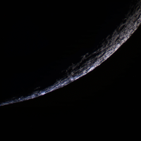
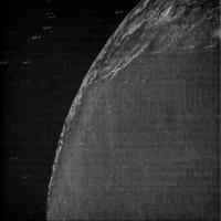
The following version has been processed to reveal the nightside. As these are not long-exposure images and the JPG compression destroys dark, low contrast details not even large scale features are visible on the nightside. However, Iapetus' entire limb is apparent and the irregular terminator looks nice:
|
Posted by: Michael Capobianco Sep 9 2007, 04:18 PM
It sure looks like the Belly Band postdates Henri and is superimposed on top of it, which has some interesting implications. I guess we'll be able to tell for sure in the next set of images.
Posted by: Rob Pinnegar Sep 9 2007, 05:47 PM
If the degraded basin that is right next to Henri is going to be visible on this flyby, maybe it should get a name too.
Posted by: volcanopele Sep 9 2007, 08:15 PM
Which degraded basin? Henri is rather degraded.
Michael Capobianco, that's my sense too, that the equatorial ridge here is built-up on top of Henri's ejecta.
Posted by: Stu Sep 9 2007, 10:50 PM
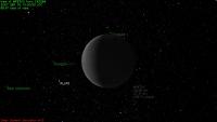
Hey, how's this for a "family portrait"..? Pioneer 11 and Voyager 1 - with New Horizons - all in the same field of view as Iapetus during tomorrow's encounter?
|
I know we won't actually see them, but kinda cool to think they'll be "in the area"...
Posted by: volcanopele Sep 10 2007, 01:13 AM
Just a little update. This evening, we can expect to get three observations down from the spacecraft: ISS_049SA_SATSYSFIA001_PRIME, ISS_049IA_M33HRS001_PRIME, and ISS_049IA_GLOBMAPG001_PRIME . The first two is meant as a family portrait image set. SATSYSFIA001 can be thought of as a Kodak moment-type observation as Cassini images the entire Saturnian system from near-Iapetus using both the WAC and NAC cameras. Expect lots of ring NAC images and distant images of all the major moons of Saturn, plus a Wide-angle camera overview. M33HRS001 is an Iapetus observation immediately following SATSYSFIA001. Iapetus will almost fill the view in this observation. Hopefully, the targeting will be spot-on and I can use this image for controlling the other crescent/Saturn-shine images that come down later tonight and tomorrow. This view will have a pixel scale of 1.7 km/pixel. Finally, ISS_049IA_GLOBMAPG001_PRIME will also come down. This observation is a two-frame mosaic of the crescent at 1.3 km/pixel. CLR and UV3/GRN/IR1, as well as GRN polarized, images are expected for each footprint. These images are expected between 9 and 10pm tonight (though they could show up as early as 8:30pm, depending on how the Raw images page ingests images).
Tomorrow morning images from the ISS_049IA_LIMBTOPOG001_PRIME and ISS_049IA_SATUSHINE001_PRIME observations will come down. LIMBTOPOG001 is a two-frame mosaic of the crescent at 800 m/pixel. CLR and UV3/GRN/IR1, as well as GRN polarized, images are expected for each footprint. Saturn-shine observations over both poles are also expected with this observation. Expect anywhere from 0.82 to 1 pixel of smear in these Saturn-shine images. ISS_049IA_SATUSHINE001_PRIME is also expected. This sequence includes a four frame mosaic over the the crescent, 2 three-frame mosaics in saturn-shine over the polar regions, a frame over the ridge, and a frame over the south-western part of the impact basin in northeastern Cassini Region ("Joan"). These images are expected to be on the raw images page sometime between 7:15 and 8:15 am tomorrow morning.
Posted by: volcanopele Sep 10 2007, 01:54 AM
Emily, those features along the ridge are superimposed impact craters:

|
Posted by: mgrodzki Sep 10 2007, 02:13 AM

also made with infrared, GRN and ultraviolet
Posted by: elakdawalla Sep 10 2007, 02:39 AM
Ah. Of course. It's obvious, now that you've explained it to me. I didn't recognize them because of the foreshortening. If it were less of a crescent view, there would have been craters along the ridge to compare them to, like in the image you showed; but with just the crescent illuminated it was quite mysterious.
Nice map!
--Emily
Posted by: Decepticon Sep 10 2007, 03:57 AM
Here we go again!
http://saturn1.jpl.nasa.gov/multimedia/images/raw/raw-images-details.cfm?feiImageID=126174
Posted by: Rob Pinnegar Sep 10 2007, 04:01 AM
There's another one just to the southeast of Henri that is about the same size but is even harder to see. There isn't much left of it, but you can see it when it is close to the terminator.
Somebody pointed it out a year or two ago -- I can't remember who noticed it first.
[Edit: If you look at the collage of Iapetus images from the first page of this thread, it's visible in the images from the 7 o'clock and 8 o'clock positions on the "wheel".]
I hope we get the chance to see the Iapetus shots within the next couple of days after the close encounter. Good job this is happening on a Monday morning -- it would've been torture if it had been on a Friday.
Posted by: elakdawalla Sep 10 2007, 04:20 AM
The latest set looks like http://www.geoinf.fu-berlin.de/projekte/cassini/detail_iss_049ia_m33hrs_img.html and appears to be perfectly targeted. Well done team!
EDIT: and here's my composite of that one. It's got stacked IR and Red for red, stacked green and clear for green, and just blue for blue (the UV3 one was a bit JPEGGy and cosmic-ray-hit to do much with)
|
I was busily erasing cosmic ray hits from the short-wavelength channels when I noticed that there seemed to be a "hit" in the same place on two of the channels. Three light spots, actually, repeated from channel to channel, which means they weren't hits, they were features; they were the pole-facing southern rims of three craters north of the equator. Neat! There was also one longer-exposure clear image in this observation, and you can see the outline of the limb -- with a hint of some interesting topography -- and maybe one mid-sized crater in the north polar area by Saturnshine, but not much else.
Also a few images from ISS_049IA_GLOBMAPG001_PRIME seem to be up, but not all of them.
Bedtime for me; I'll have to wait until tomorrow to see what Santa has brought!
--Emily
Posted by: JRehling Sep 10 2007, 05:09 AM
[...]
Posted by: Steve G Sep 10 2007, 05:42 AM
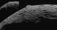
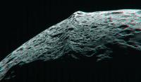
This one is about 60,000 km closer, crudely enhanced and rotated for easier interpretation. Looks like a crater chain running parallel to the ridge.
|
Posted by: Steve G Sep 10 2007, 06:06 AM
Man must explore. And this is exploration at its greatest - Dave Scott
Posted by: David Sep 10 2007, 06:52 AM
I just can't get over the strangeness of that mountain chain so abruptly interrupting the otherwise smooth curve of Iapetus' horizon. It is unnatural -- and yet wonderful, too.
And yes, there does seem to be a linear feature running parallel to the equator. Maybe more than one. That makes the phenomenon all the stranger.
Posted by: ugordan Sep 10 2007, 09:58 AM
I was struck by how lumpy this body is as seen in this http://saturn.jpl.nasa.gov/multimedia/images/raw/raw-images-details.cfm?feiImageID=126165. Another thing is the 3 stars visible aren't streaks at all despite longer exposure. Cassini was obviously tracking Iapetus and the stillness of the stars suggests Iapetus wasn't moving in Cassini's windshield much at the time - more or less just growing bigger and bigger.
Posted by: Stu Sep 10 2007, 10:14 AM
Thought I'd have a go, everyone else is going to!
|
Posted by: ugordan Sep 10 2007, 11:07 AM
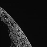
Wow!!! http://saturn.jpl.nasa.gov/multimedia/images/raw/raw-images-details.cfm?feiImageID=126214
This is it, at 62 000 km it's already twice the resolution we ever got!
Just look at that rigde, like some alien spine creeping around the moon!
Where's that swear bucket when you need it?
Posted by: akuo Sep 10 2007, 11:20 AM
Amazing views and it's only going to get better.
I don't actually remember, how high are the peaks in the mountain ridge?
Posted by: Bjorn Jonsson Sep 10 2007, 11:36 AM
The highest ones are about 20 km high.
Not unexpectedly, that ridge looks ancient. At a quick glance it seems just as heavily cratered as the terrain near the ridge.
I noticed several 'black' images. I hope these are Saturnshine shots that the automatic contrast stretch didn't handle well and not images where Iapetus got missed. The fact that they are all CL1/CL2 suggests the former may be the case.
Posted by: TritonAntares Sep 10 2007, 11:58 AM
Looks like saturnshine pics:
http://saturn.jpl.nasa.gov/multimedia/images/raw/casJPGFullS33/N00091816.jpg http://saturn.jpl.nasa.gov/multimedia/images/raw/casJPGFullS33/N00091811.jpg
Much noise in there...
Till later...
Posted by: Stu Sep 10 2007, 12:02 PM
Am I seeing things that aren't actually there, or is there a parallel feature running alongside the main ridge on both sides..?
|
Posted by: ugordan Sep 10 2007, 12:04 PM
I believe the 10 consecutive "black" images are part of ISS_049IA_SATUSHINE001_PRIME:
- Eight long exp. 32s (fullres., g=3); two 2sum (46s + 32s, g=3)
I suspect they're black because cosmic noise confused the histogram stretcher. Saturn is in a more favorable saturnshine phase now, ~35° (rev B/C was ~70°).
Funny how we're seeing WAC frames now similar in resolution to what NAC saw a couple of days ago:
Except WAC PSF makes everything look blurrier.
Posted by: Phil Stooke Sep 10 2007, 12:18 PM
Here's the view with saturnshine on the limb. A composite of three frames.
Phil
|
Posted by: ugordan Sep 10 2007, 12:26 PM
Phil, I don't know why, but that composite reminds me of Voyager 2 Triton encounter for some reason.
Posted by: Rob Pinnegar Sep 10 2007, 12:36 PM
Probably 'cause Iapetus' black streaking resembles the wind-blown geyser plumes.
Also: Stu, that's an interesting observation about the attendant linear features paralleling the main bellyband. The one on the right looks like it might be just a fortuitous arrangement of craters -- but it does seem that there might be something there.
Posted by: Bill Harris Sep 10 2007, 01:36 PM
Today's the day and I'm absolutely a-bubble with excitement. Dreamt last night that the dark material on Iapetus was billions and billions of 2x3x5 (or 4x9x25) meter-tall black monoliths...
And Oppy is getting ready for the entry into Victoria. Can life get much better?
--Bill
Posted by: volcanopele Sep 10 2007, 02:03 PM
Well, I guess you guys get the real-time feed... interesting.
Stu, the ridges parallel to the main ridge were seen during the New Year's 2005 encounter. According to Giese et al. (in press in Icarus), these are caused by flexure as the heavy load of the ridge is supported by the thick lithosphere.
Posted by: ugordan Sep 10 2007, 02:05 PM
What do you mean by this?
P.S. Bill, it can always be even better!
Posted by: volcanopele Sep 10 2007, 02:15 PM
Usually, we get the images several hours after the end of the downlink. That's how I calculated the 7:15-8:15am PDT arrival times for the images on the JPL raw images page. During the Iapetus encounter, however, we get the images in a "real-time" feed, meaning we see the images shortly after (within 15-30 minutes) they hit the ground, during the downlink. However, I expected the JPL raw images page to load the images several hours after the downlink, on the "Non-real-time" feed. But the fact that people were already looking at the images at 4:20am PDT tells me that you guys are getting them as soon as we are seeing them.
Posted by: Rob Pinnegar Sep 10 2007, 02:16 PM
Well, we're past C/A now. Hope we get some images soon!
BTW, I assume that the scale of the "bellyband flexure" probably tells us something about the rigidity of the Iapetan lithosphere (and perhaps its thickness, at least thickness-at-the-time)?
Posted by: ugordan Sep 10 2007, 02:19 PM
@VP: Well, if it's any consolation to you, the last downlink (yesterday, starting 14:15 UTC) certainly didn't feal "real time" to us. Unless the imaging data was downlinked at the very end of the pass, there was an obvious delay because no new images were posted on the raw page as of 21:30 UTC. I'm inclined to think the raw posting mechanism isn't totally automated, rather it is triggered by someone after the DL is complete. Who knows...
Rob, the way I see in Emily's table, we might not see any new images until tomorrow's huge 14 hour, partly redundant downlink. The next downlink (2 hrs duration) might only contain RADAR SAR data. That huge downlink is scheduled to begin something like 07:00 UTC September 11th.
Posted by: Mariner9 Sep 10 2007, 02:19 PM
I know there are a couple downloads scheduled during the flyby. Anyone know approximately how often and when the Raw Images site is going to updated today?
And may I add along with everyone else, Oh my f***ing g**d!!!
(no, no, that was "feeling good". You people think I would really swear like that on a public forum?)
Posted by: Mariner9 Sep 10 2007, 02:22 PM
Oops. Sorry. I didn't refresh my browser for a few minutes, and the "how often are we getting downloads" discussion has already happened.
But I'm still feeling good. This is great stuff. Flyby of a lifetime.
Posted by: Stu Sep 10 2007, 02:33 PM
VP: thanks for the info on the parallel ridges, there was a bell ringing at the back of my mind about that but I'd forgotten the details.
Seriously guys, how amazing is this? Front row seats for almost real-time exploration of one of the solar system's most fascinating bodies?! I've managed to see Iapetus in my humble 4.5" telescope a few times... on very clear, still nights, through the light pollution above Kendal... and now I'm looking at images of a dinosaur spine crater-pocked mountain ridge on its surface, almost as soon as they reach Earth! What a fantastic example of what Doug was talking about in his recent presentation - the sheer joy and genuine excitement of "joining in" with a mission and feeling part of it. Many, many thanks to whoever (deliberately or accidentally!) is allowing us to drool over these pictures so quickly.
A true "THIS is how it should be done!" lesson to other space agencies, mentioning no names of course, haha... 
Posted by: JRehling Sep 10 2007, 03:51 PM
[...]
Posted by: Ant103 Sep 10 2007, 03:51 PM
Hi
Impressive flyby now And some images to produce .
These are my tries :
Narrow angle camera, today.
|
RVB wide angle cam
|
And an oversaturate pic to view more clearly color differences
|
I'm waiting for narrow RVB images...
Posted by: volcanopele Sep 10 2007, 03:53 PM
Here is what I could glean from the playback schedule. Please take time values with a grain of salt. They can be off by a few hours (usually on the plus side). So if ORSHIRES001 doesn't show up at 1:06am PDT, don't come here screaming that something has gone wrong. BTW, all times are in Pacific Daylight Time (this is just copied from my personal notes):
FP1NITMAP001_CIRS - Monday, September 10 - between 2:43 and 3:49 pm
CASSREG001_PRIME - Tuesday, September 11 - between 12:13 and 12:16 am
ICYMAP003_UVIS - Tuesday, September 11 - between 12:16 and 12:31 am
ICYEXO009_UVIS - Tuesday, September 11 - between 12:31 and 12:45 am
ORSHIRES001_VIMS - Tuesday, September 11 - between 12:49 and 1:06 am
FP1DAYMAP001_CIRS - Tuesday, September 11 - between 7:19 and 8:00 am
IAPETUS013_VIMS - Tuesday, September 11 - between 12:51 and 1:00 pm
REGMAPTRL001_PRIME - Tuesday, September 11 - between 2:59 and 4:07 am
REGCOLTRL001_PRIME - Tuesday, September 11 - between 4:22 and 4:42 am
IAPETUS010_VIMS - Wednesday, September 12 - between 8:05 and 9:05 pm
LIMBTOPOI001_PRIME - Wednesday, September 12 - between 8:05 and 9:05 pm
IAPETUS004_CIRS - Thursday, September 13 - between 7:50 and 8:50 pm
Posted by: belleraphon1 Sep 10 2007, 03:57 PM
Thanks indeed to all those who have made this possible!!!!
Any one else out there old enough to remember the JPL "Blue Room" broadcasts during the Voyager mission? Our local PBS station aired those, and I will never forget watching the commentary of Hal Masursky and, I believe it was Larry Soderblom, as the first Voyager close encounter Io images were being downlinked. The sheer JOY of major discovery happening before our eyes!!!!!
Now here we are 28 years later watching Iapetus reveal itself to us all with data we can save and play with.
Another world develping before our eyes... are there really words that can express the emotions here????
Yes, indeed Stu.... this is how it should be done.
Craig
Posted by: elakdawalla Sep 10 2007, 04:02 PM
--Emily
Posted by: ugordan Sep 10 2007, 04:22 PM
Here's my stab at the mosaic, click for full-res:
http://i108.photobucket.com/albums/n15/ugordan/Iapetus_clear.jpg
I took care of varying distances between footprints and they match pretty nicely. The dynamic range on this thing is so big I had to overexpose the northern section a bit even while reducing contrast to make Cassini Regio better visible. I'll try a color one next, but the UV frames are smeared pretty badly.
Posted by: elakdawalla Sep 10 2007, 04:42 PM
Nice work!
The UV images are really blurry. Just putting them together in an RGB doesn't work very well (first image). However I found that you can get rid of a lot of the blur and still preserve a little bit of the color information by stacking it with the clear-filter image first. Not ideal, but much better looking.
|
|
--Emily
Posted by: Stu Sep 10 2007, 05:18 PM
Excellent work on the images sent back so far, well done everyone! Anyone else just want to go to bed right now and wake up when the close-ups are in?
Speaking of which, based on what we've seen today, and the detail we've seen on this part of the Great Wall (HATE "Belly Band", sorry!) has anyone out there an idea just what the images of the Voyager Mountains will actually show? Will we see peaks glinting in the sunlight? More avalanche features? Just curious because I'm giving a talk to an astro society in Carlisle on Thursday night, and although it was meant to be just about Titan I'm making space to feature Iapetus fly-by images too...

|
Even if no-one has any actual predictions, what would you like to see on those images of the mountains?
Posted by: ugordan Sep 10 2007, 05:33 PM
Here's the best I could do to get some color out of the lower resolution filters. The UV filter proved most problematic (particularly in the right half of the mosaic), with its high noise and blur. I'm not too keen on the blue ice to the north, but its for keeping with the spirit of previous composites.
http://i108.photobucket.com/albums/n15/ugordan/Iapetus_color.jpg
Posted by: Steve G Sep 10 2007, 05:35 PM
In the old days, (Mariner 69 was the first instance for me) I remember watching all the US and Canadian news casts hoping they'd cover a flyby. If lucky, they did. Then I went through the newspapers, then rushing to the stores on the following Wednesday to pick up Time and Newsweek. Finally, about 6 weeks later, Sky & Telescope (and briefly Star & Sky - remember that one?) would have the best pictures.
How times have changed! Having them almost live, and then having you guys doing absolute amazing stuff has given me a front seat. Life doesn't get much better. Thanks!
Posted by: tedstryk Sep 10 2007, 05:39 PM
How times have changed! Having them almost live, and then having you guys doing absolute amazing stuff has given me a front seat. Life doesn't get much better. Thanks!
I remember during Voyager's approach to Neptune, I would ride my bike to a local newstand and check every paper for news. If I found anthing substantial, I would buy it (on the days I had any money). I would also make trips by the library to see what was in Science and Science News.
Posted by: Steve G Sep 10 2007, 05:51 PM
Yes, and Aviation Week as well. I'd hate to admit how much pilfering of library magazine pages adorned my scrapbooks! National Geographic was about a 5 month delay. I did manage to buy some amazing books at the book store at JPL during my one and only visit during my honeymoon in 1980. It was closed to the public, and I pleaded that I had come all the way from Montreal and they actually gave my wife and I a pass and we got a bit of a grand tour.
Posted by: JRehling Sep 10 2007, 05:52 PM
[...]
Posted by: tedstryk Sep 10 2007, 05:53 PM
I used photocopies, but I used to have boxloads. NG was a delay, but the quality was phenominal. I only had rare access to Aviation Week when I would get to go to a larger college library in another town.
Posted by: volcanopele Sep 10 2007, 05:57 PM
I still have the three giant binders full of Io info from when I would go to the public library in my hometown of Leavenworth, KS and print off page after page of info on Io that I could find on the internet or copy from a book.
Posted by: elakdawalla Sep 10 2007, 06:13 PM
Beat me to it, Gordan! Here's my effort. (Details will be posted shortly on the blog.)
|
--Emily
Posted by: ugordan Sep 10 2007, 06:29 PM
Nice one! Looks like your color is more consistent through the footprints than mine, except for the leftmost part where a touch of green is noticeable.
Posted by: elakdawalla Sep 10 2007, 06:45 PM
That leftmost one was tough, because it was both dark and dark -- both dimly lit and dark-colored. I really had to sink the levels down low to make it sort of match.
Blog entry now posted http://www.planetary.org/blog/article/00001125/.
Now I gotta go prepare for a $*(#^ dinner party...why can't my relatives check the space calendars before they try to schedule family events? 
--Emily
Posted by: ugordan Sep 10 2007, 06:49 PM
You can often alleviate this problem a bit if your footprints overlap. After you adjust color for each filter, you flip through overlapping layer portions through each RGB filter in Photoshop and take note if brightness appears to change in the overlapping region. You can match colors better this way as you're looking for difference, something the eye's good at picking out.
Posted by: ElkGroveDan Sep 10 2007, 07:20 PM
My wife has http://www.google.com/search?sourceid=navclient&ie=UTF-8&rls=GGLD,GGLD:2005-05,GGLD:en&q=dominos+pizza+pasadena%2cca for such schedule conflicts when she's working against a deadline.
Posted by: ngunn Sep 10 2007, 07:27 PM
And an oversaturate pic to view more clearly color differences
OK just to stop me thinking about it what is that poorly registered red/green spot in the sky quite near the equatorial ridge in your middle image? A star? I don't see it on other processed versions.
Posted by: CAP-Team Sep 10 2007, 08:36 PM
it's these days, same as the day the huygens lander landed on Titan, you'd want to sit and check every tv station and/or website covering the event, hoping to see the new incoming images the first.
Can's wait to see the new high-resolution images from the bright side of Iapetus. Emily did a really nice job with the image posted above!
Posted by: volcanopele Sep 10 2007, 08:39 PM
Yeah, that's a star. There are a few that show up in the sky in the Iapetus images.
Posted by: TritonAntares Sep 10 2007, 09:39 PM
|
The next dowlink:
So maybe earliest in 4 or 5 hours - time to have some sleep...
Posted by: elakdawalla Sep 10 2007, 09:39 PM
Here's an attempt at stereo on the ridge. Did I do this right? I'm never really sure if I've assembled stereo images correctly; my eyes always give me topo-from-shading and I have trouble looking past that unless things REALLY leap out. The two images I used were
http://saturn.jpl.nasa.gov/multimedia/images/raw/raw-images-details.cfm?feiImageID=126188
and
http://saturn.jpl.nasa.gov/multimedia/images/raw/raw-images-details.cfm?feiImageID=126214
|
--Emily
Posted by: volcanopele Sep 10 2007, 09:58 PM
You may need to rotate them so that they are both pointed north up. However, I am not sure there is enough difference between the geometry of the two images. I am assuming you used the two frames from SATUSHINE001? The sub-s/c longitude changed by 1/2 of a degree between the two. I would wait until the WAC from ORSHIRES001 - trigger number 2901 comes down. That would make a much better stereo pair.
Posted by: elakdawalla Sep 10 2007, 11:27 PM
Yes, they're the two from SATUSHINE001; the second of them was described as "ridge stereo" so I assumed that's what they were for. But after more fiddling I'm giving up, as it seems that there just isn't enough difference between them to make the point of view any different between "left" and "right." One's 10% closer to Iapetus than the other but Cassini didn't move around the limb enough to make any difference.
--Emily
Posted by: Bjorn Jonsson Sep 11 2007, 12:47 AM
WOW!!!!!!!!!!!!!!!!!!!!!!! :
http://saturn.jpl.nasa.gov/multimedia/images/raw/raw-images-details.cfm?feiImageID=126229
http://saturn.jpl.nasa.gov/multimedia/images/raw/raw-images-details.cfm?feiImageID=126228
Less than 1500 km from Iapetus! Still trying to figure out what I'm seeing, for some reason my brain/eyes combination wants to see cones where I think I should be seeing craters.
Posted by: Bjorn Jonsson Sep 11 2007, 12:54 AM
Weird, the links to the images no longer work. Here is one of them that I managed to save before this happened:
|
Posted by: Bjorn Jonsson Sep 11 2007, 12:58 AM
Direct links to the JPGs apparently work:
http://saturn.jpl.nasa.gov/multimedia/images/raw/casJPGFullS33/N00091840.jpg
http://saturn.jpl.nasa.gov/multimedia/images/raw/casJPGFullS33/N00091841.jpg
http://saturn.jpl.nasa.gov/multimedia/images/raw/casJPGFullS33/N00091842.jpg
(as should be obvious from this string of messages I'm rather excited about this )
Posted by: tedstryk Sep 11 2007, 01:33 AM
Those really are amazing!
Posted by: mgrodzki Sep 11 2007, 01:34 AM
where did emily and ugordan get the hires of each filter for that crescent image? the only IR1, GRE and UV files i saw were pretty lo-res.
Posted by: ElkGroveDan Sep 11 2007, 01:52 AM
Just stunning. The words "very old" keep coming to mind.
Whatever is making it black must be something akin to electrostatic molecular coating. Even the finest dust or other particles after all these eons would show some kind of accumulation. All we see are raw untouched ancient crater fields.
Posted by: mchan Sep 11 2007, 01:56 AM
Reminds me of the closeups of the similarly battered limb of Dione, where as Dione's surface looked like ice, Iapetus's surface looks like rock.
Posted by: volcanopele Sep 11 2007, 02:01 AM
They probably did what I did, combined each color filter image with the full-res, clear filter image.
Posted by: edstrick Sep 11 2007, 02:03 AM
N00091839.jpg is also accessible by a direct link.
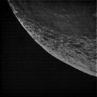
The limb here is MUCH smoother than in 91840, to the "right" of the bellyband and near the start of the high latitude light terrain.
|
Posted by: mgrodzki Sep 11 2007, 02:06 AM
combined them?
that is probably where any abilty i have to do this stuff drops off. i am only combining the IR, GRE and UV into the R, G, B channels in photoshop.
< place embarrassed emoticon here >
Posted by: volcanopele Sep 11 2007, 02:09 AM
ed, where did that image come from... 
Posted by: edstrick Sep 11 2007, 02:14 AM
Because I cannot now open the mid-sized image for the most recent narrow angle frames (as noted above), and then get to their full-rez raw frames, I opened the raw for
http://saturn.jpl.nasa.gov/multimedia/images/raw/casJPGFullS33/N00091828.jpg
and changed the last digits in the address bar to 39 and hit "enter".
Voila.
I just tried looking for the next WA frame after W00035137 and get "The Page You Requested Is Not Available", so we can work around bugs or whatever in the software but not "cheat" and get files that aren't there yet.
Posted by: Ian R Sep 11 2007, 02:58 AM
Here's my contribution to the Iapetus party:
|
*Yawn* I'm off to bed then!
Posted by: TritonAntares Sep 11 2007, 03:10 AM

|
Only six new images have been transmitted so far - probably prior to a large RADAR data downlink.
I think these images are connected with those CIRS observation mentioned above - but actually I'm not sure and I can't appreciate the numbers of NACs and WACs we see there now...
EDIT: Info from Tilmann - 2 are the only ISS-shots of http://www.geoinf.fu-berlin.de/projekte/cassini/detail_iss_049ia_fp1nitmap_cirs.html prior to a large RADAR SAR data set from the dark side.
Posted by: volcanopele Sep 11 2007, 03:28 AM
ICYEXO003_UVIS
=========
http://saturn.jpl.nasa.gov/multimedia/images/raw/raw-images-details.cfm?feiImageID=126232
(I presume the bright spot near the center of the image is Nunki or Sigma Sagittari)
ICYMAP003_UVIS
=========
http://saturn.jpl.nasa.gov/multimedia/images/raw/casJPGFullS33/N00091840.jpg
http://saturn.jpl.nasa.gov/multimedia/images/raw/casJPGFullS33/N00091841.jpg
http://saturn.jpl.nasa.gov/multimedia/images/raw/casJPGFullS33/N00091842.jpg
FP1NITMAP001_CIRS
=========
http://saturn.jpl.nasa.gov/multimedia/images/raw/casJPGFullS33/N00091839.jpg
http://saturn.jpl.nasa.gov/multimedia/images/raw/raw-images-details.cfm?feiImageID=126231
So we got a little bit more than we expected.
Posted by: antipode Sep 11 2007, 03:31 AM
This surface makes most of Earth's moon look young....
P
Posted by: nprev Sep 11 2007, 03:52 AM
Yeah... ...doesn't look like it ever had anything in the way of a major resurfacing event like the lunar maria, ever, at least the terrain we've seen. Think that exogenic origin of the splotch is looking more likely now...
Anyone else find these close-ups oddly evocative of Phoebe?
Posted by: CosmicRocker Sep 11 2007, 04:31 AM
Good catch, antipode. I was so caught up in the wonder of the encounter that I somehow managed to miss that.
Posted by: dvandorn Sep 11 2007, 05:58 AM
I don't know about anyone else, but in some of these images I'm seeing very definite evidence of material flow, in a direction that, if the shadows aren't playing tricks on me, seems parallel to Iapetus' orbital motion.
In other words, it looks a lot to me like most of the larger craters have debris on opposite sides, filling in both inner walls to some degree but piled up a bit more on the far sides (in relation to their orientation towards the direction of orbital motion). The debris patterns seem to consistently apply themselves 180 degrees apart on the larger crater rims (i.e., the thickest or most obvious sections of the debris accumulations lie approximately 180 degrees apart along the rims), and the vector through these points in the crater walls seem to align with direction of orbital motion.
I'm getting my concept of the direction of orbital motion from the shadow angles and from my (admittedly extremely rough) concept of where these regions lie in relation to the equatorial ridge. In any event, to make it a little simpler, it looks like the vector defined by the 180-degree-seperated rim distortions points back toward the center of Cassini Regio, i.e., towards the center of the region Iapetus that faces into its direction of orbital motion.
It will be more instructive, and prove more, when I can see exactly where these images are located and where those vectors actually point. After all, you *could* (and, on many Solar System bodies, do) see the same kind of phenomenah emanating from basins. But while some of this looks like ejecta, more of it looks like, well -- duning. To me.
This debris accumulation looks less obvious in the inter-crater "plains" (as rare as they seem to be) than on the rims and floors of the larger craters. But I really do think I see very specific patterns of debris accumulation here. It would seem to support the belief that material is, or has been at some point in the past, very slowly "flowing" from the midpoint of Cassini Regio out in vectors away from the leading face's central point. What's harder to tell is whether the "flow" is more radial to the center of the leading face, or more parallel to the equatorial ridge. It may well be a combination of the two...
I'd have to say it looks like the surface is very ancient, but that that the debris accumulations (which you don't see in such abundance on the other icy moons), while relatively thin in most places, seem to definitely overlay almost all of the craters to the same extent. In other words, this material is younger than the underlying ancient surface, but thin enough that it doesn't resurface the ancient terrain, it just piles dunes and sprays of debris on top of it. It's not enough material to resurface, but it does seem to be enough material to "paint" the cratered terrain a very dark brown.
-the other Doug
Posted by: volcanopele Sep 11 2007, 06:17 AM
dvandorn, I'll have to look at these images again to see what you are talking about. Any chance you can draw up something in Paint or Photoshop to illustrate what you are talking about?
To me, these images tell the tale of a very ancient world. The surface is very heavily cratered. We do do see some relatively young craters (don't ask me for an age estimate) with flat floors, central peaks, and mild to major slumping along crater walls. We also see some very ancient craters that have been eroded by later impacts, which have ruggidized the crater floors and space weathering, which has smoothed out many of the earlier hummocks produced from slumping.
From the images that have been returned so far, expect the highest resolution images to show a relatively smooth surface with impact craters down to the limit of resolution, though it maybe interesting to see if the dark material deposition has buried some of the smallest impact craters. This would be evidenced of course by a lower limit to impact crater size. Could be interesting to see. I don't expect the kind of bouldery surface we saw at Enceladus.
Posted by: mchan Sep 11 2007, 06:21 AM
The distribution (size and number) of smaller craters (if that's what they are) in the inter-crater "plains" appear odd. There appears to be some number of craters of one narrow size range, with very few or none that are, say, twice as large and larger, or half as large and smaller. At first glance, they appeared to be a smattering of huge boulders.
Posted by: edstrick Sep 11 2007, 06:59 AM
<beats his head on the keyboard in frustration>
When, did somebody say, is the next batch of pictures likely to be posted?
Posted by: TritonAntares Sep 11 2007, 07:10 AM
...
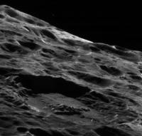
You're talking about a crater like this:
|
There seems to be some kind of debris inside, probably a landslide like in the major bassin found during the newyear encounter 2004/5.
Btw. there should have been a saturnshine image of it - did anyone see it?
Maybe it was among the completly dark pics Emily wrote about...
Posted by: volcanopele Sep 11 2007, 07:21 AM
There are Saturn-shine images. Some of them look great (over bright terrain), some of them, not so much (over dark terrain). They seems to show up as quite dark on the JPL raw images page.
Not sure when the images from the current downlink will be on the raw images page. They are coming down, and so far look good.
Posted by: edstrick Sep 11 2007, 07:32 AM
Ooooh. <tries not to drool on his keyboard>
Posted by: ugordan Sep 11 2007, 08:01 AM
Is it me or does Iapetus' surface look different than other icy moons at this scale? The surface is saturated with big craters and then peppered by very small ones at certain locations. It almost looks like it's missing "intermediate" crater sizes. Another thing in that picture is the bright terrain near the horizon, is that the transition region?
Fascinating and very crisp imagery, considering the difficulties with exposure for dark material at high phase angle. So far only UV3 frames were underwhelming, but that might change as well as phase angle rapidly decreases after C/A.
Can't wait to see the Voyager mountains pop up.
EDIT: Regarding bright terrain, nevermind. Just looked up Tilmann's page and yes the limb shot catches a bit of northern transition zone.
Posted by: brellis Sep 11 2007, 08:09 AM
It's definitely had some "ring events". In many places the surface looks like it slammed into a ring or stream of substantial objects at substantial velocity.
Posted by: edstrick Sep 11 2007, 08:16 AM
It's not critical in terms of science that the UV frames be crisp. In terms of making pretty pictures, IR vs Blue will give nearly the same result as IR vs UV, but with less color contrast, and the UV data could be used to adjust color balance and saturation of data with blue substituted for UV.
Posted by: ugordan Sep 11 2007, 08:21 AM
Agreed, but when all you have in short wavelength range are UV frames, it can be sort of critical. I don't expect Cassini to be taking other filters before the outbound hit-it-with-all-we-got shot due to bandwidth and time constraints.
Examining that limb shot further, notice the diffuse appearance of bright ice on northern-facing crater walls. John Spencer's sublimation theory is really growing on me more with each image like this. As to what seeded the leading hemisphere with darker stuff - well...
Posted by: TritonAntares Sep 11 2007, 11:05 AM
Some news from Tilmann:
The http://www.geoinf.fu-berlin.de/projekte/cassini/detail_iss_049ia_limbtopog_img.html data has sadly been lost due to mechanical problems at the Madrid recieving station.
Fortunately the 2 times better resolved data of http://www.geoinf.fu-berlin.de/projekte/cassini/detail_iss_049ia_satushine_img_crescent.html could be stored completly.
Perspective of both is nearly the same.
3 footprints of http://www.geoinf.fu-berlin.de/projekte/cassini/detail_iss_049ia_orshires_vims_2901_img.html (each footprint 5 images including 3 color shots and 1 WAC)
have been arrived, rest is missing...
If Madrid isn't able to solve the trouble, the data set would get lost and a second downlink to Goldstone will follow, but not before 17:00 UTC ending at midnight in central europe.
Posted by: ugordan Sep 11 2007, 11:09 AM
Does this mean the rest of ISS_049IA_ORSHIRES001_VIMS will be inevitably lost or retransmitted to Goldstone? Darn DSN. It's either mechanical problems or Rain in Spain... This set looks like high priority data, I'm hoping this is where the redundant downlink kicks in.
Posted by: akuo Sep 11 2007, 12:02 PM
I bet they are making extra sure that they get this downlink in Goldstone.
Posted by: TritonAntares Sep 11 2007, 12:40 PM
Data of ISS_049IA_ORSHIRES001_VIMS will definitely transmitted to Goldstone (if transmission to Madrid fails) as double playback, partly today after 17:00 UTC until 24:00 and the rest tomorrow evening.
Hopefully without mechanical trouble there...

Rain in Spain... I don't believe.
Probably Siesta & Sangria...

Perhaps we'll enjoy the transmitted parts of Trigger 2901 on the raw images page soon.
Posted by: akuo Sep 11 2007, 02:14 PM
New images have appeared!
http://saturn.jpl.nasa.gov/multimedia/images/raw/raw-images-list.cfm?browseLatest=1
Posted by: dvandorn Sep 11 2007, 02:14 PM
|
|
There seems to be some kind of debris inside, probably a landslide like in the major bassin found during the newyear encounter 2004/5.
Btw. there should have been a saturnshine image of it - did anyone see it?
Maybe it was among the completly dark pics Emily wrote about...
I'm specifically speaking of this image and the larger composite of this area that has been posted previously by several people.
Look at the pattern of the debris flow here. The rim is degraded, but not all along its extent. The major degradation runs from the left edge, through the floor, and up the right edge (as seen in this image), with a linearity to the debris on the floor that parallels the points on the walls that are most heavily degraded.
If you look closely at the surrounding area, you can see similar "ponding" or "pooling" of debris along the "right" and left" crater rim arcs, not so much on smaller craters but very definitely noticable on the larger craters.
All I have available for image manipulation on my system is your basic MS Paint -- I'll try and annotate one of these images later today and highlight what I'm seeing.
-the other Doug
Posted by: ugordan Sep 11 2007, 02:21 PM
Wow.. Wide-angle: http://saturn.jpl.nasa.gov/multimedia/images/raw/casJPGFullS33/W00035140.jpg
NACs:
http://saturn.jpl.nasa.gov/multimedia/images/raw/casJPGFullS33/N00091843.jpg
http://saturn.jpl.nasa.gov/multimedia/images/raw/casJPGFullS33/N00091847.jpg
http://saturn.jpl.nasa.gov/multimedia/images/raw/casJPGFullS33/N00091851.jpg
I take it these are from the partial ISS_049IA_ORSHIRES001_VIMS?
Posted by: tasp Sep 11 2007, 02:23 PM
{nevermind}
Posted by: tasp Sep 11 2007, 02:26 PM
{nevermind}
Posted by: dvandorn Sep 11 2007, 02:30 PM
You're seeing blanketing, too, tasp? Good, I was beginning to think I was going crazy...
Yeah, I'm seeing debris blanketing at various levels. Some of it seems pretty thick and exhibits mostly parallel striations, some of it seems very thin. But I'm definitely seeing a variety of blanketing processes going on here.
-the other Doug
Posted by: alan Sep 11 2007, 02:32 PM
I think the shadows are playing tricks with his mind.
There is some bright material scattered around the small crater just left of center.
http://saturn.jpl.nasa.gov/multimedia/images/raw/casJPGFullS33/N00091847.jpg
Posted by: tasp Sep 11 2007, 02:38 PM
{invert the pictures}
Shadows playing tricks on elevations and depressions in pictures.
Imagine my chagrin . . .
Posted by: Tman Sep 11 2007, 02:38 PM
Wide-angle rotated http://www.greuti.ch/cassini/iapetus_w00035140.jpg
At first glance it looks like the ridge is partly heavy eroded from a distinctive pointed form.
Posted by: JRehling Sep 11 2007, 02:41 PM
[...]
Posted by: jamescanvin Sep 11 2007, 02:44 PM
These ones http://saturn.jpl.nasa.gov/multimedia/images/raw/casJPGFullS33/N00091847.jpg and http://saturn.jpl.nasa.gov/multimedia/images/raw/casJPGFullS33/N00091851.jpg are a close up of the ridge. It matches the center of the http://http://saturn.jpl.nasa.gov/multimedia/images/raw/casJPGFullS33/W00035140.jpg image.
James
Posted by: ugordan Sep 11 2007, 02:45 PM
JRehling, if you're talking about tiny white splotches, I was wondering about those as well. It would be a lot better to have calibrated images as well as align lower resolution color data over them (can't do this myself, still at work) to be sure they're real, not artifacts. They appear slightly fuzzy so are not very likely to be cosmic ray hits.
Posted by: TritonAntares Sep 11 2007, 02:50 PM
3 ridge WACs are up...

|
Distance: 8594 km
Posted by: JRehling Sep 11 2007, 02:55 PM
[...]
Posted by: ugordan Sep 11 2007, 02:58 PM
Is it just my imagination or do these splotches preferentially occur on north-facing slopes?
Posted by: jamescanvin Sep 11 2007, 03:07 PM
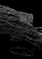
Here is a quick context image for these new ridge NAC's
|
First time I've done anything with Cassini data.
James
Posted by: pgrindrod Sep 11 2007, 03:13 PM
James,
You can add in the third NAC just to the right of the ridge as well.
|
First time I've tried this with Cassini too!
Pete
Posted by: ngunn Sep 11 2007, 03:18 PM
The spread of the dark stuff according to Spencer's theory.
Some small, extremely fresh craters that break through the dark layer.
Mass movement that surfaces the bright stuff. Possibly in areas where the dark stuff never existed in high concentrations in the first place.
Certainly nothing contradicts this model so far. If we are seeing small patches of exposed sub-surface bulk material then it would certainly look very bright in dark terrain images. In bright terrain areas, however, these patches if visible at all should show up as somewhat darker than their surroundings. Finding that would clinch it for me.
Posted by: jamescanvin Sep 11 2007, 03:19 PM
Ah that's how it goes. I assumed I fitted somewhere but these shadows on this topography does my head in.
Posted by: ugordan Sep 11 2007, 03:24 PM
Seeing small bright patches of roughly the same size but with varying brightness peppered across the area in my mind is a clear evidence that whatever is happening down there is a slow darkening process. Presumably an ongoing one.
These are still distant views at 8000 km and if we're lucky we might catch a few more of those fresh bright splotches closer in before swinging on to the bright side. It's great UV3 frames are pretty crisp, looks like a different gain mode or lower exposure was used.
Posted by: Phil Stooke Sep 11 2007, 03:26 PM
You know you're having fun when the Wide Angle frames look like that!
Phil
Posted by: pioneer Sep 11 2007, 03:33 PM
These images show an ancient terrain that to me shows no signs of volcanic or techtonic activity. I also get the impression the dark terrain clearly does not originate from the interior through geyser or volcanic activity. I'm leaning in the direction it comes from Phoebe or Hyperion.
Posted by: ChrisP Sep 11 2007, 03:36 PM
What a wonderful way to avoid completing my assignment (in cosmology :-).
Looking at these images and the presumed angle of the Sun, I wonder if the bright streaks are due rather than to a difference in the material of the surface, but more to there being a single material which has a preferential angle for reflecting sunlight?
Posted by: Elias Sep 11 2007, 03:43 PM
It would be interesting to try to resolve (if possible) how many craters on the equatorial ridge are stretched and how many are not.
Whatever the origin of the ridge is, it should have led to the stretching of pre-existing craters on top of it. After the ridge formed, all impacts on top of it should have formed ''normal'' craters.
Therefore measuring a ratio of streched to normal craters could provide a hint to the formation time of this feature. If all craters are streched then the ridge should have formed after the bombardment period and the opposite...
I am not sure, however, if stretched craters can be identified...
Posted by: Littlebit Sep 11 2007, 03:43 PM
Nah! That possibility is completely at odds with preconceptions:)
Posted by: Tman Sep 11 2007, 03:49 PM
Ah that's how it goes. I assumed I fitted somewhere but these shadows on this topography does my head in.
There should be six NACs to stitch finally: http://www.geoinf.fu-berlin.de/projekte/cassini/detail_iss_049ia_orshires_vims_2901_img.html
Posted by: ngunn Sep 11 2007, 03:49 PM
I think this is likely a contributory factor. Most surfaces display a degree of specularity when viewed very obliquely. Try it with a sheet of paper - preferably the black part of a printed image of Iapetus!
Posted by: JRehling Sep 11 2007, 03:53 PM
[...]
Posted by: Bjorn Jonsson Sep 11 2007, 03:58 PM
You see that on the Earth's oceans -- even on solid surfaces on places like Mars and Enceladus. But I haven't seen a trace of that in global imagery of Iapetus.
Hmmm... I don't remember seeing it on Enceladus but it has been seen on Mars. Enceladus' opposition surge is very strong though.
Posted by: ngunn Sep 11 2007, 04:02 PM
Maybe only in strongly backlit thin crescent images? Are we really sure we see no hint of global scale specularity there? I think it would be hard to say for sure. The surface is certainly not in any sense glossy like Earth's oceans but there could be a small effect under extreme lighting and viewing conditions.
Posted by: Bjorn Jonsson Sep 11 2007, 04:04 PM
Usually the outer planet satellites exhibit a strong opposition surge. This implies a porous surface. I would be surprised if Iapetus' surface exhibited specular reflection.
Posted by: ugordan Sep 11 2007, 04:05 PM
The ridge peaks always (well, since two days ago) striked me as having a bit of specular component to them, I don't know if it's real or just overexposure of somewhat brighter terrain there.
Posted by: Floyd Sep 11 2007, 04:15 PM
Pools of oil (very dark) give nice specular reflection. If the dark coating on Iapetus is like a layer of dark oil, we would expect specular reflection off of the surfaces that are at the correct angle. The surface of Iapetus is so createred that only a small percentage surface area would be would be at the correct angle---ie the view we have been examining.
Posted by: ugordan Sep 11 2007, 04:47 PM
A rough attempt to overlay lower resolution color data onto a clear image:

|
Noisy is the word. It does show, however, that those bright splotches are also bright in UV, something you'd expect from cleaner ice. No attempt at realistic color, just surface differences.
Posted by: JRehling Sep 11 2007, 04:49 PM
[...]
Posted by: Ant103 Sep 11 2007, 05:14 PM
Wow, some beatiful pictures here . You work fast and the result is great .
Here is an attempt to an anaglyphic picture on the http://saturn.jpl.nasa.gov/multimedia/images/raw/casJPGFullS33/W00035140.jpg :

|
Posted by: Phil Stooke Sep 11 2007, 05:19 PM
My version of the high res mosaic.
Phil

|
Posted by: ugordan Sep 11 2007, 05:31 PM
A better example of bright material is that apparently fresh crater ejecta seen in N00091847 (rotated 180 deg):

|
4 additional bright patches visible above center and a really bright one at left.
Posted by: ugordan Sep 11 2007, 07:16 PM
http://saturn.jpl.nasa.gov/multimedia/images/raw/casJPGFullS33/W00035141.jpg
Voyager Mountains ahoy?
Posted by: Floyd Sep 11 2007, 07:18 PM
Ugordan--What you show is clearly not specular reflection!
JRehling--What I was referring to was the brightness of the near side of most craters in the above images. I'm not sure if this is just normal reflection, or has some small specular component to it. We don't know the surface roughness--a black sandy surface, even if coated with an oil like substance would probably not give very much specular reflection.
Posted by: ChrisP Sep 11 2007, 07:18 PM
You mean the small crater at about 4 o'clock from the centre? That is fairly convincing evidence of different materials. Here's 2x blowups from the above images.

|

|
Interesting comments and images, thanks.
Posted by: ugordan Sep 11 2007, 07:19 PM
Yes, Chris, that's precisely the one. I'm getting around 300 meters diameter for the suspect crater.
Regarding the latest wide angle raw image, wow that sure is one hell of an abrupt transition! Looks like a part of ISS_049IA_ORSHIRES001_VIMS, trigger http://www.geoinf.fu-berlin.de/projekte/cassini/detail_iss_049ia_orshires_vims_2902.html.
I like one of the goals here:
Posted by: elakdawalla Sep 11 2007, 07:34 PM
Whoah!  PLEASE get the next images down fast, Cassini, I'm on the edge of my seat!!
Posted by: TritonAntares Sep 11 2007, 07:48 PM
Next ridge image:

|
White backside on those mountains.
The craters seem to be older than the built up of the ridge - some kind of grown up with it...
Posted by: elakdawalla Sep 11 2007, 07:53 PM
Tilmann was positively beaming as he described this observation to me. He wasn't sure the targeting was just right; if this image is any indication; it was! The rest of the observation should actually show the mountains rising over the horizon as Cassini flies along the ridge. I can't wait to see it -- going to be quite a ride!!
--Emily
Posted by: Bjorn Jonsson Sep 11 2007, 08:02 PM
Specular reflection was always extremely unlikely and in this particular image it is obvious that the bright 'spots' are exposed ice. And this is a WA image so any NA images are going to be interesting. Can't wait to see more, these are among the strangest and most impressive images I have ever seen.
Posted by: JRehling Sep 11 2007, 08:12 PM
[...]
Posted by: David Sep 11 2007, 08:31 PM
Those mountains are amazing. Imagine the view from the top of one of them -- you'd be able to see a huge fraction of Iapetus' surface.
Posted by: TritonAntares Sep 11 2007, 08:41 PM
News from Tilmann:
Lots of images are coming in...
Trigger 2901 and 2902 having some losses ,
but 2903 und 2904 are complete.
Posted by: ugordan Sep 11 2007, 08:47 PM
What's with those raws, anyway? Seems like they're using Galileo's HGA to send them to the raw page!
Posted by: elakdawalla Sep 11 2007, 09:04 PM
Give your refresh buttons a rest; I've heard we can expect a dump of images to the raw page starting at about 3:30 PDT.
--Emily
Posted by: pioneer Sep 11 2007, 09:21 PM
Don't you mean Galileo's LGA?
Posted by: ugordan Sep 11 2007, 09:22 PM
No I mean HGA! The images aren't appearing, are they...
Posted by: scalbers Sep 11 2007, 09:57 PM
--Emily
Hey that means I have a whole half hour to try and catch up on my crescent image mapping
Posted by: ugordan Sep 11 2007, 10:00 PM
And just in time for my bedtime, too.
Posted by: TritonAntares Sep 11 2007, 10:12 PM
News from Tilmann:
Trigger 2903 till 2908 are complete, http://www.geoinf.fu-berlin.de/projekte/cassini/images/049Ia_2909_nac_fom1.png is comming in...
Sequence 2902 - Voyager-mountains rising on horizons - will probably downlinked sometime tomorrow - hopefully...
Pics will soon be enjoyable at the raw images page...
Posted by: volcanopele Sep 11 2007, 10:18 PM
Cassini Flies By Walnut-Shaped Moon Iapetus
http://saturn.jpl.nasa.gov/news/press-release-details.cfm?newsID=773
Basically all the data has been recorded, it is just taking a little longer to playback. Most of the highest resolution data is now on the ground, with the rest to come back tomorrow morning
Posted by: ngunn Sep 11 2007, 10:19 PM
That is a pivotal observation. I had not envisaged that, even though I was worried about the idea of altitude-dependent temperature producing white peaks on an airless world. So much food for thought I've got indigestion already - and its only just beginning.
Posted by: ugordan Sep 11 2007, 10:24 PM
Safe mode? Were any outbound science observations lost due to this? The news release doesn't specify which "post-flyby" downlink that was.
Posted by: scalbers Sep 11 2007, 10:26 PM
This could call into question whether we'll get some of the medium distance outbound imagery that would be good for mapping?
Posted by: ugordan Sep 11 2007, 10:29 PM
That's what I was thinking as well. That would include the http://www.geoinf.fu-berlin.de/projekte/cassini/detail_iss_049ia_iapetus010_vims.html sequence, one using every possible filter combination to take a global view. Disappointing. I'm finding it rather unnerving the power trip had to happen this week, of all...
Posted by: volcanopele Sep 11 2007, 10:30 PM
It was the first downlink last night. We got 15 minutes or so of images, then nothing. Playback resumed around 11:30am PDT today during the middle of the second scheduled playback period. Images should start showing up soon on the JPL raw images page.
We have another playback tomorrow morning that will be used for carryover. As far as I know, all data acquisition planned for the next few days has been canceled, which includes some full-disk Iapetus observations.
Posted by: AlexBlackwell Sep 11 2007, 10:32 PM
Interesting, in the sequence is the following command subsequence:
PWR_SSRA_049IA_IRRITATE_GORDANU
Posted by: Sunspot Sep 11 2007, 10:34 PM
Sounds like the encounter has been a disaster then.
Posted by: ugordan Sep 11 2007, 10:36 PM
That's funny, Alex, but I was really looking forward to some nice low phase global views. Damned http://www.unmannedspaceflight.com/index.php?s=&showtopic=3782&view=findpost&p=89080 got to us after all. 
Posted by: elakdawalla Sep 11 2007, 10:37 PM
Far from it. All the highest-res observations were successful and are going to be downlinked. The sequence was halted about 6 hours after closest approach, so the outbound full disk stuff got scrapped, which is a bummer, but there is more than enough amazing data to keep everyone busy for a long time. It's just not going to be quite as much as they had planned for.
We're lucky we even know how much data acquisition was planned.
--Emily
Posted by: SFJCody Sep 11 2007, 10:37 PM
Odd that the press release says 'no impact on Iapetus Science data return'
Of all the major icy satellites, Iapetus has the biggest 'terra incognita' patch in the global maps, and this flyby would have more or less filled it...
Posted by: ngunn Sep 11 2007, 10:39 PM
I really don't think that's an appropriate description. Let's see what we have when the dust settles. It will be amazing enough.
Posted by: AlexBlackwell Sep 11 2007, 10:39 PM
I agree. The C/A observations are the most important ones, and they've been spectacular.
Posted by: belleraphon1 Sep 11 2007, 10:40 PM
Sunspot..
this has certainly not been a disaster.... let us count our blessings. The hit could have happened a few hours earlier... that would have been bad.
We have an invaluable set of observations. We need to be patient.
The up side is that perhaps this will convince the mission planners to add another Iapetus flyby at the end of the extended mission.
But can't wait for the Voyager mountains in high res.
Craig
Posted by: AlexBlackwell Sep 11 2007, 10:42 PM
Given the difficulty of targeting Iapetus in any tour, yes, it would have been nice to have a flawless flyby. However, just imagine if the C/A observations had gotten hosed.
Posted by: OWW Sep 11 2007, 10:43 PM
Does this mean we will have no global images of the sunlit side AT ALL? That's a disaster for the mapping gurus I would think....
Posted by: AlexBlackwell Sep 11 2007, 10:46 PM
You know, you "this-has-been-a-disaster" guys all need to calm down and get some perspective. I don't know how you would have survived the last several Io flybys during the final Galileo mission extension, when safe mode seemed to be the normal state of the spacecraft.
Posted by: ugordan Sep 11 2007, 10:50 PM
Far from me saying this was a disaster, but your analogy with Io flybys is a little off. You always had the next Io flyby if the current one failed Besides, I'm sure everyone understood the risks of flying by Io.
This was a one-shot thing. It was supposed to be a routine flyby, more or less. Stupid cosmic ray power trip...
Posted by: OWW Sep 11 2007, 10:50 PM
Ok, compared to I33 this has been a success. This situation is similar to what happened with Galileo on E19.
Posted by: Ian R Sep 11 2007, 10:52 PM
Typical - the first safe mode event for four years had to occur just after the Iapetus flyby...
Posted by: AlexBlackwell Sep 11 2007, 10:53 PM
In this business, it would be a good idea to eliminate "routine flyby" from one's vocabulary.
Posted by: ugordan Sep 11 2007, 10:54 PM
Ian - what? Solid state power switch trips occur several times a year, each time safing the s/c. We don't always hear about them, they're mostly mentioned in Cassini weekly reports.
Alex, point taken.
No raws yet, I'm calling it a day... and a flyby.
Posted by: scalbers Sep 11 2007, 10:54 PM
Yes the thrill of spaceflight. I'm looking to see if we'll get either of the 250m resolution outbound images that would be just before the downlink in question:
http://www.geoinf.fu-berlin.de/projekte/cassini/detail_iss_049ia_iapetus013_vims.html
http://www.geoinf.fu-berlin.de/projekte/cassini/detail_iss_049ia_iapetus013_vims_img.html
I'm curious as well about what this might mean for the extended mission(s).
Posted by: Roby72 Sep 11 2007, 10:57 PM
We're lucky we even know how much data acquisition was planned.
--Emily
6 hours after C/A - that means that this sequence (and also the following six ! ) are lost:
http://www.geoinf.fu-berlin.de/projekte/cassini/detail_iss_049ia_regmaptrl_img_map.html
Robert
Posted by: OWW Sep 11 2007, 10:58 PM
Was the WAC snapping pictures just before the downlink?
Posted by: volcanopele Sep 11 2007, 11:01 PM
Of all the major icy satellites, Iapetus has the biggest 'terra incognita' patch in the global maps, and this flyby would have more or less filled it...??? We will fill that gap, don't worry! Just not tonight...
It certainly has not been a disaster. Aggravating, but not a disaster. We will get nearly all the high-resolution science we planned on.
By the way, the REGMAPTRL001 images are just fine! Most of that just won't get played back until tomorrow.
Posted by: Juramike Sep 11 2007, 11:04 PM
On one hand, it's a bummer. On the other hand, it gives us another chunk of "Here there be tygers" terrain in the solar system to look forward to discovering in the futue.
"Some see the glass as half full,
some see the glass half empty,
and some see it as time for another round."
-Mike
Posted by: Rob Pinnegar Sep 11 2007, 11:08 PM
That is really too bad about the full-disk sequence. It would have been nice to see all of Roncevaux Terra at much-improved resolution. I do hope that at least some of the images of the large basin come through. [Edit: I didn't see Jason's above post before saying this.]
The important thing is the high-resolution stuff, though, and that seems to be safe.
Posted by: Bjorn Jonsson Sep 11 2007, 11:08 PM
I get the impression that poorly imaged terrain isn't going to be any bigger than would have been the case had nothing gone wrong. Seems to be global multispectral coverage that was lost.
Posted by: belleraphon1 Sep 11 2007, 11:14 PM
some see the glass half empty,
and some see it as time for another round."
-Mike
Remember Voyager 2? We lost all the high res on Tethys and Enceladus when the scan platform seized up.
Plus all the post close encounter flyby science except for a long distance Phoebe image. Amend that, we did get particles and fields data.
The glass is definitely more than half full, and this just means we go for another round (extended mission).
Craig
Posted by: scalbers Sep 11 2007, 11:19 PM
It certainly has not been a disaster. Aggravating, but not a disaster. We will get nearly all the high-resolution science we planned on.
By the way, the REGMAPTRL001 images are just fine! Most of that just won't get played back until tomorrow.
That sounds very encouraging - thanks for the report. We would then see the global mosaic of the receding lit side. It will just be slightly more challenging to map without the best quality global context view (except we might later get something from roughly 700000km distance). There'll be plenty of time though for that!
Posted by: JRehling Sep 11 2007, 11:20 PM
[...]
Posted by: Ian R Sep 11 2007, 11:21 PM
Gordan - I was referring to the article on the Cassini website that stated: "The last time Cassini was in safe mode was over four years ago."
Posted by: OWW Sep 11 2007, 11:22 PM
I thought REGMAPTRL001 was after the fateful downlink? Shouldn't it be lost?
Posted by: Roby72 Sep 11 2007, 11:23 PM
It certainly has not been a disaster. Aggravating, but not a disaster. We will get nearly all the high-resolution science we planned on.
By the way, the REGMAPTRL001 images are just fine! Most of that just won't get played back until tomorrow.
A few CIRS global maps should also be gone. And outbound RADAR data...
BTW, I m happy that the REGMAPTRL001 sequence is ok
Robert
Posted by: monitorlizard Sep 11 2007, 11:28 PM
I don't think we can count on another Iapetus flyby to be added to the extended mission. After all, they worked on designing the extended tour for a couple of years, so it's pretty much set in stone. But there is predicted to be approx. 125 m/sec delta-V left for Cassini at the end of the extended mission, making an extended extended mission possible. Another Iapetus flyby should get some consideration for that, though I would have wished for a reason other than data loss in this flyby.
Fortunately, an extended extended Cassini mission fits in perfectly with Alan Stern's "squeeze every drop of science out of every spacecraft" philosophy.
Posted by: Rob Pinnegar Sep 11 2007, 11:38 PM
It'd be nice to see another flyby, but with the science objectives from this one having apparently been fulfilled, that just doesn't seem too likely. Yeah, it'd be nice to see the Moat in sunlight, but that's probably not worth the trouble of setting up another flyby in three or four years' time.
On the lighter side, I just checked out the Front Page list of all the members currently browsing Unmanned Spacecraft. About 25 right now, almost all of whom are fairly obviously here for the Iapetus flyby.
Posted by: volcanopele Sep 11 2007, 11:40 PM
The REGMAPTRL001 sequence occurred on September 10 at 22:40 UTC and ran through September 11 at 00:40 UTC. The first downlink started on September 11 at 05:30 UTC. We got most of the first frame and expect the rest during tomorrow's downlink.
Posted by: OWW Sep 11 2007, 11:43 PM
I keep staring and staring at the timeline:
http://planetary.org/news/2007/0906_Cassini_Zeroes_in_on_Saturns_YinYang.html
But I don't see any REGMAPTRL001 before the +6h mark. I really can't see how REGMAPTRL001 could have survived. Am I missing something?
EDIT: thanks VP.
Posted by: OWW Sep 11 2007, 11:52 PM
From Emily's blog:
Maybe a small error?
Should it read 14 hours and 05:10? That would be a small relief.
Posted by: Rob Pinnegar Sep 12 2007, 12:00 AM
Umm. So if I'm correctly reading the information from Jason, and from the mission timeline:
(1) There was a very brief downlink 6 hours after C/A.
(2) A much longer downlink had been planned for 15 hours after C/A. However, a cosmic ray hit occurred just after this downlink started, delaying its completion by a couple of days, but not leading to any loss of data.
There seems to be some confusion regarding which of (1) and (2) constitutes the "first post-flyby data downlink". Number (2) would have been the first MAJOR post-flyby data downlink.
Maybe the fact that the cosmic ray hit happened to occur around 6:00 UTC contributed to this?
Posted by: Phil Stooke Sep 12 2007, 12:10 AM
Here's another of the saturnshine images - a composite of three frames. Not very pretty...
Phil
|
Posted by: elakdawalla Sep 12 2007, 12:11 AM
You're quite right, Rob, my error I've now fixed my blog entry.
Very, very sorry to have scared you all, folks.
Can't imagine why the data hasn't hit the raw page yet. I now won't be able to work on these pictures anymore until the baby goes to bed. It may be an early bedtime tonight...
--Emily
Posted by: Rob Pinnegar Sep 12 2007, 12:23 AM
I've now fixed my blog entry.--Emily
Hey, no worries, I'm just glad to hear that things are less-than-half-as-bad as we thought.
As for the delay in getting the pictures up, I'm guessing hunger may have had something to do with that. We'll likely see the images as soon as the team members finish eating supper.
Posted by: Mariner9 Sep 12 2007, 12:30 AM
I live only a few miles from JPL.
You think I should drop some pizzas off at the front gate on the way home?
Posted by: tedstryk Sep 12 2007, 12:34 AM
Phil
|
|
Amazing....It is apparently made of rectangular panels!

Posted by: Bjorn Jonsson Sep 12 2007, 12:39 AM
I've now fixed my blog entry.This is a *huge* relief. I was starting to think that maybe, just maybe this was something worse than the impression I was getting from the JPL news release and from what has been posted here by those with detailed knowledge of the sequences/observations. Still would have been very far from disastrous but now the loss seems minor so I'm happy again
.
Posted by: TritonAntares Sep 12 2007, 12:39 AM
I'm glad to realize http://www.geoinf.fu-berlin.de/projekte/cassini/tabelle_iapetus_flyby.html could be stored.
We have all outbound observations till 630 m/pxl (REGMAPTRL001) and this nice global coverage:
|
An extra encounter after the extended mission would be desireable to fill the gap at the longitude of the snowman and the polar (mainly the southern) regions...
So raws, come on...
Posted by: alan Sep 12 2007, 12:40 AM
Get out your swear jars
http://ciclops.org/view_event.php?id=67
Posted by: Bjorn Jonsson Sep 12 2007, 12:44 AM
WHAT THE... ????????!!!!!!!!!!???????????
This is amazing, strange, weird...
Posted by: cschmidt Sep 12 2007, 12:46 AM
Oh.....my.......
Posted by: nprev Sep 12 2007, 12:46 AM
...just broke mine on img #13. What the hell...could swear (ta dah, dah!) it was a Mariner 9 shot!
Posted by: ElkGroveDan Sep 12 2007, 12:48 AM
Holy smokes...what is the scale of these "snow patch" images???
I guess it's back to the drawing baords on the extended mission planning.
Posted by: Bjorn Jonsson Sep 12 2007, 12:50 AM
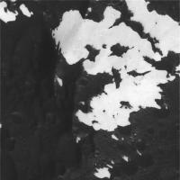
I'm posting the strangest image right here (just in case CICLOPS can't handle the load ), it's one of the strangest ones I've ever seen so it deserves to be shown here:
|
Posted by: nprev Sep 12 2007, 12:52 AM
Is the bright stuff actually the overlay? What the hell could have caused the dark stuff to accumulate in just some craters like that with no wind???
Posted by: ilbasso Sep 12 2007, 12:53 AM
Yep, so this encounter was a disaster...
NOT!!
Wow, people will be busy with this for a LOOOOOOOONG time.
If the dark material is on top, it's like it was sputtered out of something in clumps. Maybe someone was playing paintball on Iapetus.
Posted by: Rob Pinnegar Sep 12 2007, 12:54 AM
Right. This is crazy.
I thought Hyperion was the weirdest looking thing I would ever see. I was wrong.
Posted by: TritonAntares Sep 12 2007, 12:56 AM
GLACIERS?
|

|
White on black not black on white - seems to be the solution...
Posted by: nprev Sep 12 2007, 12:57 AM
Damn. Now I gotta wonder if the dark LE of Iapetus is actually the native soil that gets errant ice from Enceladus eroded off, presumably because the moon's way outside Saturn's VAn Allen region or by passes through a Titanian gas torus 2X per orbit...those dark crater spots sure look like sublimation artifacts.
Posted by: Rob Pinnegar Sep 12 2007, 01:04 AM
It's possible that the reason the bright terrain looks like a "coating" in these images is that the exposure times required to bring out details in the dark terrain are causing the bright terrain to be slightly overexposed.
Does anyone else have the sneaking suspicion that the Snowman complex probably looks a lot like this in close-up sunlit view?
Posted by: cschmidt Sep 12 2007, 01:28 AM
mm-hmm sure looks like white on black.
Could a swarm of comets cause such a wierd distribution of evenly bright material? It looks like snow. And the dark areas don't feel icy at all, they look like hammered metal, like a terrrestrial planet.
It's wonderful for us non-scientists to feel the thrill and immediacy of it all; truly awesome. Now, back to the pictures...
Posted by: belleraphon1 Sep 12 2007, 01:28 AM
HOLY FREAKAHHHHHHHHHHHHH MOLIIIIIIIIIIIIIIIEEEEEEEEEEEEEEEEEEEEEEEE!!!!!!
all right.... this clinches it.... Alan Stern will HAVE to grant an extended extended just to get back to tuxedo junction here!!!!!!!
Magnificant... nature never disappoints.
Worth the 26 year wait since Voyager 2. (not... wish more missions could be done in this frail human timespan)
Craig
Posted by: Superstring Sep 12 2007, 01:29 AM
I'm speechless.
Notice that on the white side, the few black spots are all splattered crater interiors. If the black material was/is delivered externally to Iapetus, why would it situate precisely in craters in the edge regions? I think it makes more sense to believe the craters caused the natural dark surface to upwell.
But then that begs the question, what would coat Iapetus in white material? If it's ongoing (ie Enceladus), why haven't the crater interiors been coated by now? Or maybe they are recent enough that that hasn't happened yet.
And why would the material build on the TRAILING hemisphere?? That doesn't make sense either.
I love planetary science.
Posted by: tedstryk Sep 12 2007, 01:29 AM
If someone posted this one in a Mars forum, I would totally believe this was a view of the polar regions.....superficial resemblance, but resemblance none the less. Wow!!!

|
Posted by: TritonAntares Sep 12 2007, 01:31 AM
Icy crater landscape:
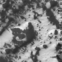
|
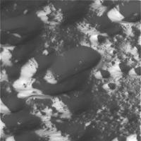
|
...and a cut-off mountain
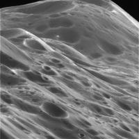
|
Where the hell are the raws ???
I'm impatiently waiting for more.
This is a really ugly kind of torture...
Posted by: tasp Sep 12 2007, 01:34 AM
(I think this is only the 2nd picture I have ever loaded here, if I don't do it right, assistance would be deeply appreciated, picture is ~32kb)
I have been looking over the "mountains over the horizon' picture and have circled some peaks. It appears, that despite their differing absolute sizes, neglecting crater damage, they are all the same shape.
A process that generates highly similar forms, regardless of scale ?? I am reminded of grain piles in the midwest, no matter how big or small they are, they all look alike.
(The one in the immediate foreground might have been a 'clone;' too, but it is all caved off now, so it's hard to tell.)
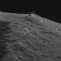
|
Posted by: tasp Sep 12 2007, 01:38 AM
(Wow, 2 pictures in one night.)
The prototype:

Posted by: nprev Sep 12 2007, 01:40 AM
I don't buy dark upwelling...that terrain is ancient, almost saturated by craters, and if there's black goo beneath the surface it surely would have fountained out with each hit. Think that the "real" Iapetus is a metaphorical chunk of coal, covered with frost or icing or whipped cream or something on the trailing side (where it sticks), but gets eroded off the leading side (by something).
Enceladus is the usual suspect for snowing on other moons, but way out here? LOTS of questions...
Posted by: JRehling Sep 12 2007, 01:42 AM
[...]
Posted by: belleraphon1 Sep 12 2007, 01:50 AM
Well...
Glass almost full.... sitting here listening to Henry Jackman version of Miserere, gazing at images of dark/white splotched alien terrain, trying to piece this together. As I finish another round of beer, my tuxedo kitten Kan Kan ponders my lap.
But must now to bed go..... dreaming of an invisible snow fall that drapes all with mysterious tones, a secret not to be revealed just yet.
Just beautiful. Beautiful.
Craig
Posted by: cschmidt Sep 12 2007, 01:54 AM
Going with the assumption that there is some type of volatile ices on top of the black, it's notable that the surface on which the white rests appears to be just as beat up as the dark areas.
That would make the white deposits more recent than the dark.
What if.... Iapetus has been hit - recently - by a cloud of snowballs...
Do the dark walls face direct solar radiation, with the ice there having sublimated?
Posted by: belleraphon1 Sep 12 2007, 02:15 AM
Ok... OK... Ok...
three quick observations and then I am REALLY going to bed.
1) Is it just the contrast between the dark and light material, or does the white stuff look like virgin snow?
Just does not look as "old and processed" as the ice on the other Saturn moons.
2) I can buy the dark stuff, however it is deposited, as eating into the white substrate.
3) We need an artist to help interpret this dark/white panoply... any air brush artists in the house?
Good night.
Can't wait to see the mountain view...
Craig
Posted by: Michael Capobianco Sep 12 2007, 02:32 AM
Ahem... not to be smug, and it is too early too say anything conclusively, but I could see this result in the stereo view of the Snowman.
Posted by me on: Mar 13 2006, 05:06 PM:
"Looking at the 3-D rendering of the Snowman/Moat in 3-D, I've come to the conclusion that in that area, at least, on the western edge of Roncevaux Terra, the dark stuff makes up a relatively thin layer with high-albedo ice below it and covering it to a shallow depth. In places, like the "dotted lines" north of the Moat, the bright ice coating is very thin. In other places, it appears the dark layer is nonexistant."
Michael
Posted by: Holder of the Two Leashes Sep 12 2007, 02:36 AM
What an extreme day.
I start out elated when I see that the first NAC images of the ridge were right on target.
Then I go home three hours ago with the latest news that the global coverage is toast, and I'm feeling kinda miserable about that.
I come back here and just a few minutes ago find out that things aren't all that bad. Still a little sad about the VIMS global (and rooting for another pass the EEM), but I least I won't have to compose a heartfelt condolence to Mr. Albers.
Then I see the latest images.
And... I... am... just...
STUNNED!!!
Posted by: belleraphon1 Sep 12 2007, 02:37 AM
Duh!!!!!
The white stuff IS virgin snow if it is the result of the dark stuff causing water/co2 ice to sublimate and migrate to colder surfaces.
Really going to bed now.
Craig
Posted by: tasp Sep 12 2007, 02:45 AM
My take on the black stuff:
Surfaces that achieve a minimum angle to the sun's rays turn dark.
Iapetus is a thermographic printer.
(And the minimum angle is related mathematically to latitude and longitude. Angle smoothly increases east and west from a point centered halfway between sub-Saturn and anti-Saturn points on the leading hemisphere. Moving north and south of the equator, the angle again smoothly increases. Light and dark regions can change at the same scale the surface angle changes right down to the resolution of the Cassini camera.)
Find out the sun angle on these pictures and sight across the dips and dales and hills and vales.
It's all geometry and sunlight.
Posted by: GregM Sep 12 2007, 03:00 AM
.
Posted by: Exploitcorporations Sep 12 2007, 03:12 AM
I broke my swear jar and ate both the contents and the glass fragments alike with a garnish of happy obscenities in as many languages as I could babel fish for. I've been in the process of moving back to Seattle after a short absence, so I've missed much of the excitement until this morning...I can't even think of an unoffensive acronym to encapsulate just how hard my jaw hit the floor with the sample of images released thus far. Special thanks to Ugordan for the view of Saturn from here (18x now...you should start up a wallpaper surcharge here). See you all here soon. BTW...my money's on the white painted over black now.
Posted by: David Sep 12 2007, 03:31 AM
On the white/black question: could it be that neither of these substances is the underlying surface -- i.e., that there is both a "snow" coating (similar to other bright icy moons) and an "ash" coating, and that, depending on surface conditions -- topography and external heating -- you can get snow over ash, or ash over snow?
In that #13 image, however, while I can imagine conditions that would give us those patterns as snow-on-ash, I can't come up with anything that makes sense for ash-on-snow. But I think we've seen other, earlier images where ash-on-snow made more sense.
Posted by: tasp Sep 12 2007, 03:33 AM
Just for fun (and maybe a bit more), here's a photo negative of the amazing splotch/snowdrift picture:
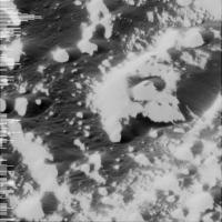
|
Posted by: tasp Sep 12 2007, 03:37 AM
OK, now think about that picture. The most intense sunlight (averaged over 40 days) is striking the white parts now. Lesser levels of illumination strike all the rest of the terrain.
Everything that is white has parallel sight lines.
There is no white in the shadow of white anywhere.
Posted by: Rob Pinnegar Sep 12 2007, 03:40 AM
More images have just come down the pipe. Quite a few more, actually.
These include some amazing shots of what look to be two of the white Voyager Mountains.
Posted by: volcanopele Sep 12 2007, 03:41 AM
Highest resolution image: http://saturn.jpl.nasa.gov/multimedia/images/raw/casJPGFullS33/N00091974.jpg
Ray Crater: http://saturn.jpl.nasa.gov/multimedia/images/raw/casJPGFullS33/N00091978.jpg
Lots of little craters: http://saturn.jpl.nasa.gov/multimedia/images/raw/casJPGFullS33/N00091970.jpg
Posted by: tasp Sep 12 2007, 03:44 AM
It 'works' on the other picture too:
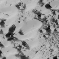
|
Posted by: nprev Sep 12 2007, 03:47 AM
Just had a thought...IF (and only if) white-on-black is correct, and IF (and only if), the white stuff is exogenic and presumably from a source in Saturn's vicinity, and IF (and only if), Iapetus is a captured object, THEN how many more pitch-black, virtually invisible Iapetii may be lurking undetected in the outer Solar System, unbound to major planets...
Three "IFs" usually is a death knoll for any theory...just thought I'd scare you all! (Congrats on the Seattle return, EC! )
Posted by: David Sep 12 2007, 03:53 AM
The curved edges and bays in the "snow" region in #14 (http://ciclops.org/view.php?id=3764) remind me of the shapes of retreating glaciers. The inverse pattern, the shape of the "ash" region, doesn't make much sense on its own.
tasp, I'm not sure I'm following your argument. Do you think you could rephrase it for a dullard?
Posted by: Rob Pinnegar Sep 12 2007, 03:53 AM
Uhhh... whaddaya call *this*???
http://saturn.jpl.nasa.gov/multimedia/images/raw/raw-images-details.cfm?feiImageID=126253
[Edit: I just tried clicking on this link and it didn't work... the image I'm looking at is N00091956.]
Posted by: nprev Sep 12 2007, 04:02 AM
Rob, can you post it for us image illiterati?
Posted by: David Sep 12 2007, 04:03 AM
I'd call 'em channels or fissures of some sort. The surrounding landscape seems to have been compressed or folded. Perhaps Iapetus wasn't always dead as a doornail! And the odd thing is that it isn't peppered over with craters. Mystery upon mystery...
And on second thought, it looks to me like the fissures are going through craters that were already there before the fissures formed. Unless there's a crater-producing process that also creates fissures?
Posted by: tasp Sep 12 2007, 04:16 AM
(I got caught on this earlier today)
Invert the picture.
The 'cracks' are actually the edges of a landslide.
The 'bumps' are craters.
These pictures are so, for lack of a better word, alien, that it is easy to get confused.
Posted by: tasp Sep 12 2007, 04:19 AM
Regarding the black and white:
Any white surface perpendicular to the sun (with some of the other angular constraints I have been outlining in other posts) turns black.
That's it.
Surface of Iapetus is covered in silver nitrate.
Posted by: David Sep 12 2007, 04:20 AM
Invert the picture.
The 'cracks' are actually the edges of a landslide.
The 'bumps' are craters.
These pictures are so, for lack of a better word, alien, that it is easy to get confused.
I did invert the picture. (Or rather, I inverted myself relative to the picture
). Still look like fissures to me. Didn't see any bumps.That can hardly explain the global distribution!
Posted by: tasp Sep 12 2007, 04:21 AM
OK, it's late, the silver nitrate thing is a joke.
But, the surface of Iapetus behaves similarly.
I think the coating is everywhere, but only when the level of insolation (not insulation) exceeds a certain value, the stuff turns black.
Posted by: tasp Sep 12 2007, 04:27 AM
The amount of the 'silver nitrate' is maximum halfway between the sub-Saturn and the anti-Saturn points, on the leading hemisphere.
The 'silver nitrate' is 'applied' every Iapetan month when Iapetus traverses the Saturnian magnetotail. It almost totally dissipates in ~ 40 days, but can persist in low spots.
Posted by: David Sep 12 2007, 04:29 AM
http://saturn.jpl.nasa.gov/multimedia/images/raw/casJPGFullS33/N00092041.jpg's a remarkable one: white field spattered with black lake-like forms. (I am not suggesting there are lakes on Iapetus! Sheesh.) Some of them are obviously crater-related, but not all of them.
Posted by: tasp Sep 12 2007, 04:31 AM
It really is a landslide. The edges of the flow have 'banked' themselves a bit.
The flow looks, um, er, 'flowy'. Might be mostly pulverized, or granular materials.
Posted by: tasp Sep 12 2007, 04:34 AM
Try not to think about spraying black powder on a white surface, or spraying white powder on a black surface.
We have something sprayed everywhere (on a white surface!), but it only turns black when it gets hot in the sunlight.
(and recall 'hot' on Iapetus is still a bit on the chilly side of dry ice)
Posted by: David Sep 12 2007, 04:38 AM
So how does a landslide get sharp ridges at the sides? Not challenging you, just curious.
Posted by: JRehling Sep 12 2007, 04:39 AM
[...]
Posted by: tasp Sep 12 2007, 04:42 AM
Same stuff is all over Hyperion too.
But the only place it gets hot enough there is at the bottoms of the craters that have walls steep enough to focus the sunlight on those crater bottoms.
And why are virtually all the crater bottoms on Hyperion black ??
Chaotic rotation eventually points all the craters directly at the sun.
So what is the 'stuff' ??
It's gaseous.
It's a gaseous photo-thermal reactive, er, um, gas.
It 'ponds' in craters and low spots on tiny grav places like Hyperion. It persists around more massive Iapetus for about half (40 days) the orbit about Saturn. That's why Cassini Regio is on the leading hemisphere.
Toot sweet.
I am going to bed, a happy camper tonight.
Posted by: David Sep 12 2007, 04:44 AM
We have something sprayed everywhere (on a white surface!), but it only turns black when it gets hot in the sunlight.
(and recall 'hot' on Iapetus is still a bit on the chilly side of dry ice)
It's a fascinating idea, but it doesn't explain (to me) the shape of the black-white boundary -- which reminds me of nothing so much as early spring snowmelt. I think the distribution you note could be explained otherwise: the white stuff melts away where it's hottest, exposing a black layer underneath. On other parts of Iapetus, it either never existed, or has been covered over with darker materials. (I'd love to see if there's any evidence of dark-light-dark layering).
Posted by: tasp Sep 12 2007, 04:44 AM
JRehling:
Wait till we get a Uranus orbit and look at Ariel!
Posted by: David Sep 12 2007, 04:49 AM
It's not really a fair comparison; Saturn has seven larg(ish) moons, Jupiter only four, so Saturn has more opportunities for wackiness; and we now have much better coverage of the Saturn system. I'm not entirely convinced that Dione beats Callisto, or that Enceladus and Europa are even comparable; but there's only one Titan in the solar system, and of course Iapetus deserves some record for having presented precisely the same mystery, without solution, for over 300 years.
And there are, as you say, the rings.
Posted by: Stu Sep 12 2007, 05:36 AM
Just catching up on the fly-by here, having been at work yesterday afternoon and evening (UK time) and so unable to sit with you all watching the images come in... wow... I hope every "disaster" in the future gives us such stunning pictures of ice-capped mountains, black-sprayed craters and the like...
Looking at these images I can't help thinking that it's a window onto the future, a hint of what it will be like on that amazing day in a century or so when the first pictures reach Earth from the first interstellar probe, and we see truly alien worlds and alien landscapes for the first time...
Looking forward to seeing those mountains now, that will be one of Cassini's greatest successes I think.
Congratulations to everyone involved in this successful mission, and, again, thank you for letting us "out here" see the images so quickly.
Posted by: Steve G Sep 12 2007, 05:40 AM
That looks like fresh snow!
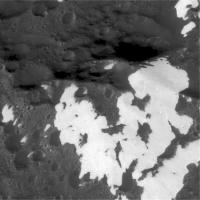
|
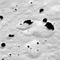
|
Posted by: alan Sep 12 2007, 05:44 AM
Recent impact of lump of dark material?
(dark ring near right edge)
http://saturn.jpl.nasa.gov/multimedia/images/raw/casJPGFullS33/N00092005.jpg
edit: never mind, I see it on some other images, its a dust spot that was enhanced by the contrast stretch.
Posted by: volcanopele Sep 12 2007, 05:46 AM
alan, That's a camera artifact. That's my evil nemesis, the Dust Moat.
Posted by: JRehling Sep 12 2007, 06:16 AM
[...]
Posted by: ugordan Sep 12 2007, 06:46 AM
Holy &%#!"!/%1#"$%/$!!!!
.... picking my jaw off the floor after getting a grip...
Regarding the white-on-black (WOB ?) theory; how exactly does that explain the several fresh craters with excavated bright ejecta? We see brighter patches like that all over the dark terrain, but we don't see dark stuff being excavated similarly. In fact, what struck me most is the sharpness of the dark boundary in predominantly white terrain.
http://ciclops.org/view.php?id=3764 literally reminds me of a Rorschach inkblot.
This has absolutely, positively been the best flyby, EVER! From the point of being able to watch it unfold in real time, having really inside info on the scientific observations and the very results in the end, this flyby will IMHO be one that define what Cassini's mission at Saturn is remembered for. The sheer beauty and grandness of these scenes (still waiting for the mountain flyover sequence!) just have to make some of this into the best picture of the year!
Posted by: hubdel11 Sep 12 2007, 08:25 AM
|
|
can't help mysellf
Posted by: akuo Sep 12 2007, 08:29 AM
Excellent flyby, kudos to Cassini team!
I asked earlier what was the height of the mountain ridge, because I've been wondering if some peak on Iapetus could take the position as the highest mountain in the solar system, thus overtaking Olympos Mons. Seeing that the ridge isn't so uniform, I think this might be possible. Could this mountain be a candidate?
http://saturn.jpl.nasa.gov/multimedia/images/raw/casJPGFullS33/W00035183.jpg
Posted by: edstrick Sep 12 2007, 08:39 AM
The limited resolution of Hubble data doesn't help, but that central peak in the south-hemisphere <damn near> crater on Vesta...it's so big it's almost a spallation-scar!... might be a candidate.
Posted by: ElkGroveDan Sep 12 2007, 08:50 AM
|
|
can't help mysellf
That is really useful. Thanks.
Posted by: edstrick Sep 12 2007, 09:03 AM
Um...
Does anybody think it would NOT be a good idea to break the nomenclature scheme and name a major basin or other feature on Iapetus after Hermann Rorschach, creator of the InkBlot test?
Posted by: ngunn Sep 12 2007, 09:14 AM
Could a swarm of comets cause such a wierd distribution of evenly bright material? It looks like snow. And the dark areas don't feel icy at all, they look like hammered metal, like a terrrestrial planet.
It's wonderful for us non-scientists to feel the thrill and immediacy of it all; truly awesome. Now, back to the pictures...
Well, up to now we've had some pretty tortured attempts to explain where the dark stuff came from. Now we see white on black and people are still reaching out for an external source - comets . . Enceladus . .
I really don't buy any of that. The source of both has to be the dirty, poorly differentiated bulk material of Iapetus itself, acted on by a continuing process that you could call a 'runaway blackhouse'. Congratulations John Spencer.
Posted by: ugordan Sep 12 2007, 09:44 AM
Are these saturnshine shots?
http://saturn.jpl.nasa.gov/multimedia/images/raw/raw-images-details.cfm?feiImageID=126370
http://saturn.jpl.nasa.gov/multimedia/images/raw/raw-images-details.cfm?feiImageID=126371
http://saturn.jpl.nasa.gov/multimedia/images/raw/raw-images-details.cfm?feiImageID=126372
The subtle and diffuse lighting appears to suggest so, but they look almost too good to be saturnshine shots. Then again, these are WAC frames and they require lower exposures, but there's something about the geometry that tells me these can't be saturnshine?
Posted by: ngunn Sep 12 2007, 09:46 AM
And now we can see why some of the 'white mountains' appeared to be off the great circle of the ridge:
http://saturn.jpl.nasa.gov/multimedia/images/raw/raw-images-details.cfm?feiImageID=126368
Posted by: ugordan Sep 12 2007, 09:52 AM
Ngunn, are you sure those are Voyager mountains? I'd say that's just part of the ridge further east, still within the dark region. Here's Emily's quick http://planetary.org/image/iapetus_cassini_transition_veryraw2.jpg of narrow angles covering the actual mountains, note the contrast is MUCH higher there.
Here's the wide-angle http://saturn.jpl.nasa.gov/multimedia/images/raw/casJPGFullS33/W00035210.jpg, rotated 90 deg counterclockwise w/respect Emily's swath, north is down.
It would appear they aren't really much of a mountain, rather a strong play of light and dark terrain.
Posted by: ngunn Sep 12 2007, 10:23 AM
unquote
No, and I believe you're right there - thanks for the correction. As to the actual mountains:
quote:
It would appear they aren't really much of a mountain, rather a strong play of light and dark terrain.
I'm not so sure about that yet. Did we not see white patches beginning to appear on the far flanks of what certainly are mountains in that earlier limb sequence?
I'm going to be lazy and wait till others assemble the jigsaw. Meanwhile I know I should keep quiet but it's difficult . . . At least I'm not alone in letting the excitement get to me.
Posted by: ugordan Sep 12 2007, 10:44 AM
I believe that 8 frame wide-angle sequence is part of ISS_049IA_ORSHIRES001_VIMS, trigger http://www.geoinf.fu-berlin.de/projekte/cassini/detail_iss_049ia_orshires_vims_2901.html, http://www.geoinf.fu-berlin.de/projekte/cassini/detail_iss_049ia_orshires_vims_2901_img.html over the ridge, changing from high phase angle to low phase angle. It's the sequence immediately preceding Voyager-mountains-on-horizon-rise sequence.
It's very difficult to navigate through all the posted images because the S/C executed that big turn around C/A and obviously a lot of the sequence data is still missing so we have sporadic fragments from some sequences. It's still great to know just what sequences there were in the first place. I KNEW this encounter would severely affect my work productivity this week!
EDIT: Both that part of the ridge and Voyager "mountains" are visible in http://saturn.jpl.nasa.gov/multimedia/images/raw/casJPGFullS33/W00035208.jpg. This http://saturn.jpl.nasa.gov/multimedia/images/raw/raw-images-details.cfm?feiImageID=126368 of the ridge can be seen about 3/4 of the way to the left from center, rotated 90 degrees and foreshortened a bit more.
Posted by: Bjorn Jonsson Sep 12 2007, 11:37 AM
Well, this has certainly affected my productivity. For the second day in a row I'm really too sleepy to get myself to do anything but 'fortunately' there is a minor ongoing 'crisis' so it's fairly easy to keep myself focused on doing something .
For two nights in a row I did a quick, last check just minutes before going to sleep in the unlikely event that some new images I had been waiting for had appeared and in both cases there were new images to look at.
These images are amazing, tonight I really want to assemble some mosaics from this stuff but I'll probably be too lazy and sleepy to do so.
I get the impression that sublimation must be an important and ongoing process on Iapetus.
Posted by: Phil Stooke Sep 12 2007, 12:14 PM
A bit of contrast change.
Phil

|
Posted by: Eric Hartwell Sep 12 2007, 12:37 PM
Here's a merge of the mostly-light region. It looks more like soot splattered onto fresh snow than snow splattered onto soot (the inset has enhanced contrast to highlight the dark trail - which might be a shadow instead).

|
Posted by: ugordan Sep 12 2007, 12:51 PM
The raws posted on Cassini's site are misleading in that they clip the lowest brightness to black. The dark stuff most likely wasn't totally black, but because no black space beyond the moon's limb was caught, it got clipped to zero. The few raws on http://ciclops.org/view.php?id=3765 site don't clamp lowest brightness to zero (and are much higher quality, btw), but they don't subtract camera bias either. With exposures optimized for bright ice, it's possible for dark stuff to appear totally black, but it's still the same brown stuff we saw on approach.
</Captain_Obvious>
Posted by: ngunn Sep 12 2007, 01:21 PM
Phil
Very nice indeed - makes a lot more sense now.
Any particular reason N is at the bottom?
Posted by: Bill Harris Sep 12 2007, 01:25 PM
Black Monoliths filled with stars? No, this is much more strange.
Review imagery of the Martian polar regions. I think that they are very close analogue.
All this time we've largely considered Iapetus to be a light, icy world with a dark sputtered-on coating. This may be largely the case, but more complex. I'm thinking an icy world, with the dark coating, and light sublimated ice with more dark coating and more light ice. Much like a layer cake.
Look at Iapetus as a heat engine, a stirling engine, or a heat pipe. Tha dark area is an efficient heat collector, the surface is the warmest in the Saturn system. The light ice reflects, and is very cold. The Sun heats the dark material, evaporates the volatiles, which condense on the light material. Causes it's own differentiation.
What causes the dichotomy? There is an interruption of the insolation cycle: Saturn. At one point in the orbit, at the time of maximum heating, Iapetus goes into eclipse, and cools very rapidly to very cold temperatures. Out of eclipse, heats up rapidly. I've not drawn out a detailed diagram of this, so I may be barking up the wrong Clarke Tree...
The Ridge Mountain? Impresses me as a granular material at angle of repose. Notice all the slumps/landslides.
I think most of what we see may be related to the Rings somehow.
Gotta run, getting pacemaker in two weeks and have a lot of last minute details...
--Bill
Posted by: djellison Sep 12 2007, 01:27 PM
He's using a really really big newtonian
Doug
Posted by: Phil Stooke Sep 12 2007, 01:33 PM
No reason, I just didn't change the orientation of the raw. Maybe I should have - it's hard to see inside this bowl.
Phil
Posted by: Bjorn Jonsson Sep 12 2007, 01:37 PM
Not one point per orbit - these eclipses are very rare.
Posted by: Juramike Sep 12 2007, 01:39 PM
Look at Iapetus as a heat engine, a stirling engine, or a heat pipe. Tha dark area is an efficient heat collector, the surface is the warmest in the Saturn system. The light ice reflects, and is very cold. The Sun heats the dark material, evaporates the volatiles, which condense on the light material. Causes it's own differentiation.
What causes the dichotomy? There is an interruption of the insolation cycle: Saturn. At one point in the orbit, at the time of maximum heating, Iapetus goes into eclipse, and cools very rapidly to very cold temperatures. Out of eclipse, heats up rapidly.
I like it.
Does this fit the pattern we are seeing in craters of the "snowy regions"?
-Mike
Posted by: Ant103 Sep 12 2007, 01:46 PM
Some anaglyphs to produce .
Before, I want to say that I can't believe again my eyes. Cassini's shots are ... incredible. Great, very great, very very ... great!
So, my anaglyphs :

|
(two others pictures on the two next posts)
Posted by: Ant103 Sep 12 2007, 01:48 PM

|
Posted by: hubdel11 Sep 12 2007, 01:49 PM
Another quick stitch :
|
|
Powered by Invision Power Board (http://www.invisionboard.com)
© Invision Power Services (http://www.invisionpower.com)