Journey to Mt Sharp - Part 1: Site 7 to Waypoint 1, Sol324 [Jul4,'13] to Sol391 [Sep12,'13] |

  |
Journey to Mt Sharp - Part 1: Site 7 to Waypoint 1, Sol324 [Jul4,'13] to Sol391 [Sep12,'13] |
 Sep 6 2013, 02:17 AM Sep 6 2013, 02:17 AM
Post
#496
|
||
 Member  Group: Members Posts: 408 Joined: 3-August 05 Member No.: 453 |
One hundred sol 384 ML thumbnails, (sort of) all in a row.
Airbag |
|
 |
 
|
|
|
Sep 6 2013, 09:40 AM
Post
#497
|
||
 Senior Member Group: Members Posts: 1465 Joined: 9-February 04 From: Columbus OH USA Member No.: 13 |
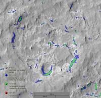
QUOTE (EdTruthan @ Sep 5 2013, 08:23 PM)  ...and mhoward - placing the MC's over the Navs and tracing that path - nicely done. That is a good way to look at things--nice to have the cardinal points on the horizon too! According to the slope map, the rover shouldn't have too much trouble navigating the basin or whatever it's called:
That's based on the HiRISE DTM, which has a resolution of 1 meter per pixel. I wonder if there are still a lot of pitfalls and obstacles on the fine scale to worry about though. The terrain looks a little rough. -------------------- |
|
|
|
|
|
|
Sep 6 2013, 01:02 PM
Post
#498
|
||
|
Solar System Cartographer Group: Members Posts: 10151 Joined: 5-April 05 From: Canada Member No.: 227 |
A rough circular pan from the current (385) location. I'll get to the map later. The orientation is probably off, I'll fix it when I have a full pan. (EDIT - I have fixed it now)
Phil
-------------------- ... because the Solar System ain't gonna map itself.
Also to be found posting similar content on https://mastodon.social/@PhilStooke Maps for download (free PD: https://upload.wikimedia.org/wikipedia/comm...Cartography.pdf NOTE: everything created by me which I post on UMSF is considered to be in the public domain (NOT CC, public domain) |
|
|
|
|
|
|
Sep 6 2013, 01:35 PM
Post
#499
|
||
 Member Group: Members Posts: 238 Joined: 15-January 13 Member No.: 6842 |
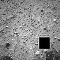
What is this black square in Navcam Right, sol 385 image: http://mars.jpl.nasa.gov/msl/multimedia/ra...354M_&s=385
-------------------- Curiosity rover panoramas: http://www.facebook.com/CuriosityRoverPanoramas
My Photosynth panoramas: http://photosynth.net/userprofilepage.aspx...;content=Synths |
|
|
|
|
|
|
Sep 6 2013, 01:51 PM
Post
#500
|
|
 Member Group: Members Posts: 813 Joined: 8-February 04 From: Arabia Terra Member No.: 12 |
QUOTE (wildespace @ Sep 6 2013, 11:35 PM) What is this black square in Navcam Right, sol 385 image: http://mars.jpl.nasa.gov/msl/multimedia/ra...354M_&s=385 Data dropout. It'll be recovered at some point in the future. |
|
|
|
|
Sep 7 2013, 06:27 PM
Post
#501
|
|
 Member Group: Members Posts: 222 Joined: 7-August 12 From: Garberville, CA Member No.: 6500 |
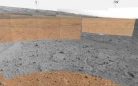
Sol 385 - MC34 - 5 Frame Panorama of the "Basin"...
Full Resolution 5766 x 1305 Pixels:  ...and a reduced resolution version with a few quick geologic correlations between the map (flipped with south as up) and the panorama... 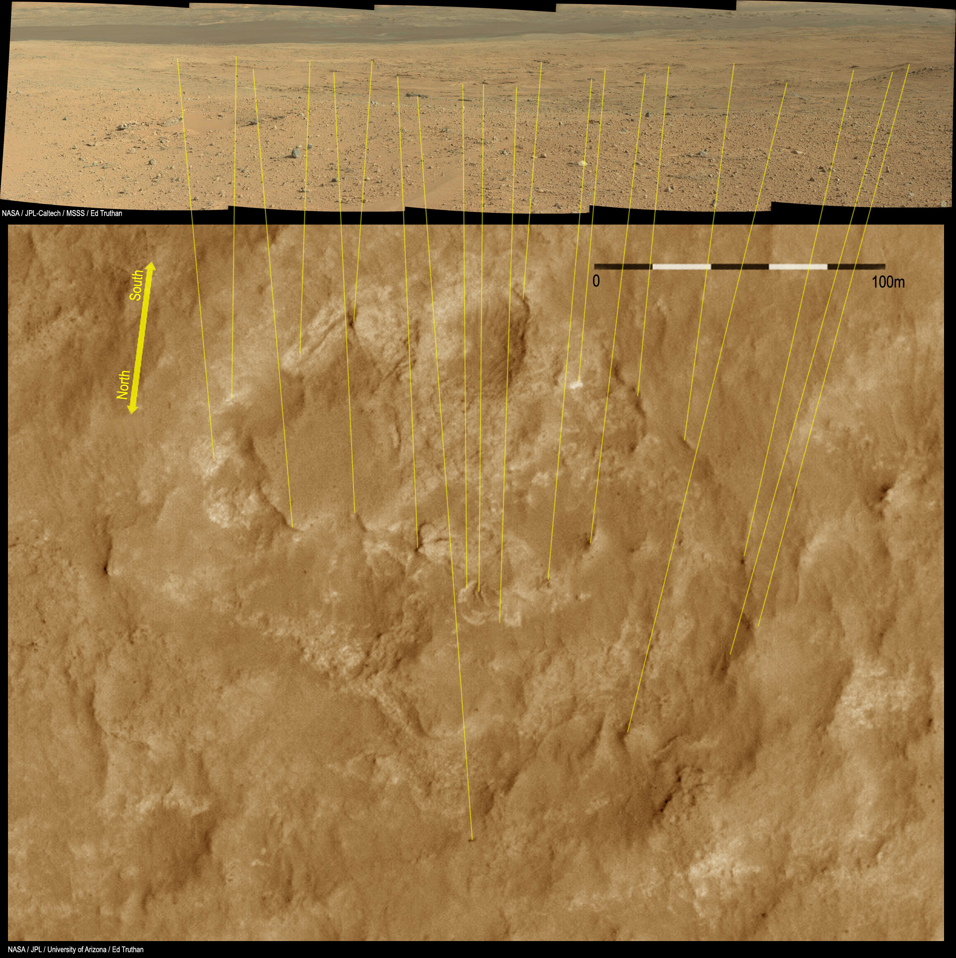
-------------------- "We shall not cease from exploration, and the end of all our exploring will be to arrive where we started and know the place for the first time." -T.S. Eliot
|
|
|
|
|
Sep 9 2013, 12:18 AM
Post
#502
|
|
|
Senior Member Group: Members Posts: 2346 Joined: 7-December 12 Member No.: 6780 |
Between those challenging night shots I just wanted to mention nice new MAHLIs, e.g. this one.
Here a color / reflectance blink made by additionally using this Sol 387 MAHLI image to calculate a difference image indicating reflectance. It may help to get an impression of the according surface structure. |
|
|
|
|
Sep 9 2013, 02:11 AM
Post
#503
|
|
|
Member Group: Members Posts: 222 Joined: 7-August 12 From: Garberville, CA Member No.: 6500 |
Sol 387...
Eight frame MC 34/100 pano from Sol 387 looking SSW to SW (centered about 216 degrees). Nice view of that small flat mesa that presides over the NW rim of the basin and the light toned outcrops beneath it. Looks like we moved 26 meters in that direction today. HIRISE images show this small rise to be dotted with several small craters, and one can be seen quite well in the anaglyph on the far right side of its flat top just before it slopes away to the north. MC 100:  Anaglyph: 
-------------------- "We shall not cease from exploration, and the end of all our exploring will be to arrive where we started and know the place for the first time." -T.S. Eliot
|
|
|
|
|
Sep 9 2013, 02:18 AM
Post
#504
|
||
|
Member Group: Members Posts: 408 Joined: 3-August 05 Member No.: 453 |
Sol 387 ML+MR pano, anaglyph.
Airbag PS, Ah, just saw yours Ed...and the irony is that I only created my version because I did not see yours earlier! |
|
|
|
|
|
|
Sep 9 2013, 11:10 AM
Post
#505
|
|
|
Senior Member Group: Members Posts: 1465 Joined: 9-February 04 From: Columbus OH USA Member No.: 13 |
A short drive on sol 388, 26 meters
-------------------- |
|
|
|
|
Sep 9 2013, 11:36 AM
Post
#506
|
|
|
Senior Member Group: Members Posts: 2346 Joined: 7-December 12 Member No.: 6780 |
Front Hazcam B x-eye stereo, looking to Sol 388 pre-drive APXS activity, fisheye-corrected 125 degrees, roughly cropped:

|
|
|
|
|
Sep 9 2013, 04:04 PM
Post
#507
|
||
|
Solar System Cartographer Group: Members Posts: 10151 Joined: 5-April 05 From: Canada Member No.: 227 |
This is the location on sol 388. The rougher unit west of us looks interesting for future investigation.
Phil -------------------- ... because the Solar System ain't gonna map itself.
Also to be found posting similar content on https://mastodon.social/@PhilStooke Maps for download (free PD: https://upload.wikimedia.org/wikipedia/comm...Cartography.pdf NOTE: everything created by me which I post on UMSF is considered to be in the public domain (NOT CC, public domain) |
|
|
|
|
|
|
Sep 9 2013, 05:37 PM
Post
#508
|
||
 Senior Member Group: Moderator Posts: 3431 Joined: 11-August 04 From: USA Member No.: 98 |
Based on the drive, I'm going to take a wild guess that we might eventually be seeing a long-baseline stereo Mastcam mosaic of the area to the south.
Attached thumbnail(s)
|
|
|
|
|
|
|
Sep 9 2013, 06:31 PM
Post
#509
|
|
|
Solar System Cartographer Group: Members Posts: 10151 Joined: 5-April 05 From: Canada Member No.: 227 |
That was my thought as well, long baseline stereo across the 'basin' to help plan activities - maybe it will have a name soon.
Phil -------------------- ... because the Solar System ain't gonna map itself.
Also to be found posting similar content on https://mastodon.social/@PhilStooke Maps for download (free PD: https://upload.wikimedia.org/wikipedia/comm...Cartography.pdf NOTE: everything created by me which I post on UMSF is considered to be in the public domain (NOT CC, public domain) |
|
|
|
|
Sep 9 2013, 07:45 PM
Post
#510
|
||
 Member Group: Members Posts: 219 Joined: 14-November 11 From: Washington, DC Member No.: 6237 |
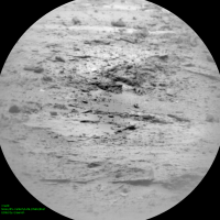
Also looks like they may be using the ChemCam RMI to look ahead. Below image DIY flat-fielded & contrast enhanced; see where it is pointed per jmknapp's site. It is part of a focus stack sequence so could perhaps yield both range and depth info.
|
|
|
|
|
|
|

|
Lo-Fi Version | Time is now: 25th April 2024 - 05:40 PM |
|
RULES AND GUIDELINES Please read the Forum Rules and Guidelines before posting. IMAGE COPYRIGHT |
OPINIONS AND MODERATION Opinions expressed on UnmannedSpaceflight.com are those of the individual posters and do not necessarily reflect the opinions of UnmannedSpaceflight.com or The Planetary Society. The all-volunteer UnmannedSpaceflight.com moderation team is wholly independent of The Planetary Society. The Planetary Society has no influence over decisions made by the UnmannedSpaceflight.com moderators. |
SUPPORT THE FORUM Unmannedspaceflight.com is funded by the Planetary Society. Please consider supporting our work and many other projects by donating to the Society or becoming a member. |
|