Printable Version of Topic
Click here to view this topic in its original format
Unmanned Spaceflight.com _ MSL _ Continuing into Glenelg
Posted by: Astro0 Nov 19 2012, 05:36 AM
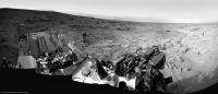
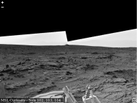
New frontiers  Sol 102
|
http://astro0.files.wordpress.com/2012/11/sol102.jpg
Posted by: EdTruthan Nov 19 2012, 09:13 AM
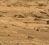
Sol 102 - 1:17pm LMST - A few final shots at Rocknest. The scoops have been driven over and are now a memory. Aloha...
http://www.edtruthan.com/mars/Sol102-Final-Shots-at-Rocknest.jpg
http://www.edtruthan.com/mars/Sol102-Final-Shots-at-Rocknest-Anaglypgh.jpg
Sol 102 - 3:23pm LMST - Saddle up the palominos boys... we're movin' again...
http://www.edtruthan.com/mars/Sol102-Leaving-Rocknest.jpg
http://www.edtruthan.com/mars/Sol102-Leaving-Rocknest-Anaglyph.jpg
Posted by: Ant103 Nov 19 2012, 12:14 PM
Ahh, it's good to see her on the road again !
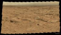
http://www.db-prods.net/marsroversimages/Curiosity/2012/Sol102_pano.jpg
Edit : anglyph version
http://www.db-prods.net/marsroversimages/Curiosity/2012/Sol102_pano_ana.jpg
Posted by: akuo Nov 19 2012, 11:07 PM
I didn't realise straight away that the sol 102 drive was a fair distance.
It was also mentioned that there was a touch-and-go, which I assume was before sol 102's drive: https://twitter.com/spaceroboticist/status/270417794376548352/photo/1
Was the touch-and-go with the APXs?
Posted by: Phil Stooke Nov 19 2012, 11:18 PM
Yes, it was.
http://astrogeology.usgs.gov/news/item/sol-102-update-on-curiosity-from-usgs-scientist-ken-herkenhoff-driving-again
Phil
Posted by: akuo Nov 19 2012, 11:41 PM
I should remember to check the Astrogoelogy news site more often. Some very rare up-to-date information there.
Looks like that there will be a check of the drill tosol.
Posted by: Zelenyikot Nov 20 2012, 07:44 AM
Maybe a little mistake with the sequence of actions 
|
Posted by: remcook Nov 20 2012, 08:15 AM
Love it!
Posted by: Ant103 Nov 20 2012, 02:45 PM
Sol 102 Navcam pan updated with Sol 103 frames
http://www.db-prods.net/marsroversimages/Curiosity/2012/Sol102_103_pano.jpg
Posted by: Phil Stooke Nov 20 2012, 03:02 PM
... and in circular format! (you would think I was just sitting here waiting for Ant103's new panorama...)
Phil
|
Posted by: Greenish Nov 20 2012, 04:01 PM
Grotzinger indicates SAM soil results could be a big deal; several more weeks before confident enough to release.
http://www.npr.org/2012/11/20/165513016/big-news-from-mars-rover-scientists-mum-for-now
Posted by: xflare Nov 20 2012, 05:56 PM
A quote from the article.
hmmm

Posted by: EdTruthan Nov 20 2012, 06:56 PM

Great pano Ant103, thanks. Very nice to see the new perspectives almost all the way round. What a difference a few meters makes ay?
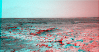
Here's a Sol 103 three frame anaglyph looking toward Phil's sea lions, and the rock slab outcrops. Catches a nice slice of the the foothills too...
http://www.edtruthan.com/mars/Sol103-Navcam-3-Frame-SSE-Anaglyph.jpg
Posted by: Phil Stooke Nov 20 2012, 11:44 PM
http://photojournal.jpl.nasa.gov/catalog/PIA16447
It seems the area we are looking at is called Yellowknife Bay.
Phil
Posted by: Astro0 Nov 21 2012, 02:11 AM
ADMIN NOTE: TO ALL...
Following the interview by MSL's John Grotzinger today, there has been much speculation about the nature of any future announcement.
We would remind everyone on UMSF about Rule 1.3. We appreciate that this is a very strict rule but we do expect everyone to follow it.
We may review and amend the rule at some future point, but for now it stands as is. Many thanks for your understanding.
Posted by: SFJCody Nov 21 2012, 02:27 AM
I'm kind of looking forward to southern hemisphere winter now (solstice on Feb 15 2014). The walls of Gale were already fairly clear after landing, but just think how much more spectacular they'll look once some of this dust settles out!
Posted by: Zelenyikot Nov 21 2012, 02:47 AM
It is interesting to me as degree of a dust content will affect RAD indications.
Posted by: ChrisC Nov 21 2012, 02:51 AM
Rule 1.3 for people like me who had no idea: Astrobiology may not be discussed here, even in the context of a mission with those stated goals. This includes other banned topics such as SETI, "Red Rain," alien visitors, exobiology, biosignatures, microorganisms, organics, fossils et cetera.
Posted by: stevelu Nov 21 2012, 04:20 AM
background on the strictness of the rule here:
http://www.unmannedspaceflight.com/index.php?showtopic=7514&hl=
some discussion here
http://www.unmannedspaceflight.com/index.php?showtopic=7187&st=15
Posted by: fredk Nov 21 2012, 05:06 AM
Remember too that one of the main points of the npr story was that there is no announcement yet, and there may never be if the result turns out to be a glitch or whatever.
But even if it holds up, "This data is gonna be one for the history books" could mean all sorts of things. A geologist might find something very important and exciting, which the public might be utterly bored by.
Posted by: serpens Nov 21 2012, 06:35 AM
Too true. Remember the hype over presidential briefing which then devolved to perchlorates? Could be anything from superoxides to carbonates. This partial leak approach is in reality a pretty poor show. Unless this is a really amazing discovery then much better to have said nothing since expectations have now been raised and disatisfaction exists where outcomes do not meet expectations.
Posted by: Cargo Cult Nov 21 2012, 10:48 AM
Is this the right place for an https://hylobatidae.org/msl-panoramas/#navcam-sol102-104? Requires a WebGL-enabled browser.
(I noticed there were enough images from NAVCAM to make a rough, 360-degree view around the rover. Images are from the right-hand NAVCAM, sols 102 through 104. There's a blurry patch where I filled up a hole in the full-resolution image with pixels from a thumbnail. The ground nearest the rover on its right-hand side (left-hand side looking back) was upsampled from 512-square downsampled images. I monkeyed round with exposure a fair amount, especially to get the distant hills vaguely visible. The whole image has been shifted down manually in Photoshop, to combat Hugin's decision to put the horizon too high. I need to find a better way of fixing that. Anyway, as a first attempt with building an interactive panorama from NAVCAM images, it worked quite well!)
Posted by: Tesheiner Nov 21 2012, 11:28 AM
This is the thread, yes. Great job!
Posted by: Stu Nov 21 2012, 11:29 AM
Loving the latest images to come back from Curiosity, some really fascinating-looking rocks...
|
Gorgeous layering in that one.
More on my blog, if anyone wants a look, just posting link here because they're waaaaay too big to post...
http://galegazette.wordpress.com/2012/11/21/and-relax
Posted by: Ant103 Nov 21 2012, 12:39 PM
Nearly full 360° anaglyph pan of Sols 102 & 103 (12.5 Mo) :
http://www.db-prods.net/marsroversimages/Curiosity/2012/Sol102_103_pano_ana.jpg
Posted by: RonJones Nov 21 2012, 04:16 PM
As for the big announcement on Curiosity results, space.com is reporting:
"Grotzinger confirmed to SPACE.com that the news will come out at the fall meeting of the American Geophysical Union, which takes place Dec. 3-7 in San Francisco."
ADMIN NOTE: ALL, until that official announcement, this is the last comment we will permit on this subject.
Posted by: newdaddy06 Nov 21 2012, 04:18 PM
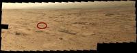
Looking at the interactive pan ("NAVCAN Glenelg") posted above, does anybody know what that bulge on the horizon (looks like maybe a Toyota Prius) is, in line with the right edge of the RTG (off the tail end of the rover)? It surely looks different than the landscape surrounding it. Maybe it's part of the entry vehicle or sky crane?
(Wish I could figure out how to include a screenshot of exactly what I am looking at, without having to put it on an external website somewhere.)
|
Posted by: elakdawalla Nov 21 2012, 04:38 PM
If it's on the horizon, it is much bigger than any of those things. Also, on your screen cap, it's right at the boundary between two images, so it's hard to tell what it is. Try going to one of the raw image websites and find the original images. See if you can find it in both eyes of the rover. Get some 3D glasses and look at Ant103's pan. Figure out what direction the rover is facing using the shadows on the ground and the time of day (Joe Knapp's raw images page has local solar time on it). Compare it to Phil Stooke's route map and see if you can find a bump that seems like it's in a reasonable location. My prediction: it's an outcrop of rock.
Posted by: Phil Stooke Nov 21 2012, 05:18 PM
It's the big lump very prominent in HiRISE images, as shown in the route map:
http://www.unmannedspaceflight.com/index.php?act=attach&type=post&id=28965
(upper left corner of that map).
It has been seen very prominently in every panorama since landing, from west, south and east as we passed it.
Phil
Posted by: fredk Nov 21 2012, 05:59 PM
Yeah, that's what we referred to as http://www.unmannedspaceflight.com/index.php?s=&showtopic=7471&view=findpost&p=191975 way back when.
Posted by: stewjack Nov 21 2012, 08:49 PM
Ya beat me to it.

I gave it a name because I hoped it might be a highly visible landmark from many locations on MSL's
early journey. If we go much deeper we may lose it for a while, but hopefully we will pick it up again on the
backtracking or westerly route. I get turned around real easy.
Posted by: ngunn Nov 21 2012, 09:40 PM
I expect the horizon to close in dramatically as we descend to 'Glenelg Destination'. Does anybody have an estimate of how many metres below our current location that is?
Posted by: Phil Stooke Nov 21 2012, 09:43 PM
It will not really be claustrophobia-inducing. A few meters below our current position, five at the most, I would expect, and a wide shallow depression. I expect 'Rocky Point' will still be visible unless we happen to park close to a steep local slope.
Phil
Posted by: Zelenyikot Nov 22 2012, 12:56 AM
After all dusty storm
http://www.jpl.nasa.gov/news/news.php?release=2012-365
Posted by: atomoid Nov 22 2012, 01:03 AM
Rocky Point 'lump' sourcefiles in the SOL 102 navcams referred to by newdaddy06 in regards to Cargo Cult's interactive pan subsequently map-pinned by Phil Stooke:
http://mars.jpl.nasa.gov/msl-raw-images/proj/msl/redops/ods/surface/sol/00102/opgs/edr/ncam/NLA_406558559EDR_F0050388NCAM00409M_.JPG http://mars.jpl.nasa.gov/msl-raw-images/proj/msl/redops/ods/surface/sol/00102/opgs/edr/ncam/NLA_406558596EDR_F0050388NCAM00409M_.JPG
http://l.nasa.gov/msl-raw-images/proj/msl/redops/ods/surface/sol/00102/opgs/edr/ncam/NRA_406558559EDR_F0050388NCAM00409M_.JPG http://mars.jpl.nasa.gov/msl-raw-images/proj/msl/redops/ods/surface/sol/00102/opgs/edr/ncam/NRA_406558596EDR_F0050388NCAM00409M_.JPG
Posted by: Cargo Cult Nov 22 2012, 10:37 AM
Thanks all!
New version up, https://hylobatidae.org/msl-panoramas/#navcam-sol102-104 - this time with a slightly better stitch (the Pointy Rock, erm, Rocky Point is no longer right on a discontinuity) and a full, non-thumbnail, non-blurry, recently-re-uplinked version of one of the images. I also allowed for the fact the rover's in a bit of a depression - the horizon is now allowed to go a bit higher than before. Exposure is a little improved as well.
I'm really enjoying gluing these panoramas together! Being able to pan around gives me a much stronger sense of place - and when that place is a distant planet? Ooooh.
(I still need to find my anaglyph specs, for other people's imagery wizardry. Being able to see all this in 3D? Even better!)
Posted by: Zelenyikot Nov 22 2012, 11:43 AM
Good! And why not to fill the sky with gray color? That there was no this black circular saw at the horizon.
Posted by: djellison Nov 22 2012, 04:42 PM
Some people like to just process images as they are, some like to add fill-in skies, people like to treat the imagery differently. Why not go ahead and do a navcam mosaic with a filled in sky yourself if that's what you want to see? That's the amazing thing about all this data being out there - anyone can have a go and do their own thing with it.. That's something to be thankful for.
Posted by: xflare Nov 25 2012, 09:53 AM
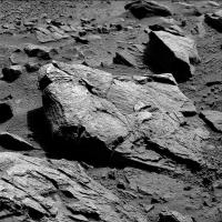
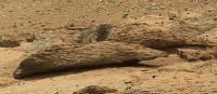
These blue/grey rocks toward the top of the image look like they were formed by something sticky and viscous - or maybe it's just a weird and strange erosion pattern.
http://mars.jpl.nasa.gov/msl/multimedia/raw/?rawid=0107MR0682042000E1_DXXX&s=107
What are people's thoughts on the formation of Glenelg?
Posted by: Cargo Cult Nov 25 2012, 10:42 AM
https://hylobatidae.org/misc/msl-curiosity-glenelg-sol-107.jpg
I have no idea as to the geological origins, but http://mars.jpl.nasa.gov/msl/multimedia/raw/?s=107&camera=MAST%5F images are up!
I've done an incredibly quick stitch just to see what's there - https://hylobatidae.org/misc/msl-curiosity-glenelg-sol-107.jpg (~9MB, ~14000 pixels across).
All kinds of differently coloured, differently shaped rocks across the landscape. Big, sharp-edged slabs, the weirdly smeary ones noted by xflare... I suspect Curiosity's going to have much work to do!
Edit: updated with better version, but still nowhere near as nice as Mr. Ant103's take below!
Posted by: Ant103 Nov 25 2012, 11:26 AM
And my take on this mosaic. Yep, this is a great vision on Glenelg rocks, layers and outcrops. I can hear from here the metalic sound of Curiosity's wheel rolling on this floor .
http://www.db-prods.net/marsroversimages/curiosity.html#74
Posted by: Zelenyikot Nov 25 2012, 12:37 PM
What can it shine if not consequences from the EDL?
http://mars.jpl.nasa.gov/msl-raw-images/msss/00107/mcam/0107MR0682028000E1_DXXX.jpg
|
Posted by: Stu Nov 25 2012, 01:01 PM
Oh, there's going to be EDL crud *everywhere*. We can't obsess about every glint or sparkle spotted on a photo, especially when there are so many beautiful rocks and so many gorgeous windblown dust dunes stretching away in all directions. Not to mention, of course, a gorgeous, skyscraping, layered, ancient mountain over there.
Posted by: Zelenyikot Nov 25 2012, 01:13 PM
However, it draws attention to itself. And if to leave without comments such objects, harmful speculation begins.
Posted by: climber Nov 25 2012, 02:35 PM
On the above pans from Ant & Cargo, we can see whitish stones on the right hand side. Very different from the rest (to my eyes)
Posted by: nprev Nov 25 2012, 02:51 PM
To steal a phrase from Stu & the UK: Absolutely gob-smacking!!!
Geological question: Given that at least a portion of this area is thought to be an alluvial fan, how much small-scale compositional diversity would be expected?
I would think that the only significant sorting would be by weight, but there seem to be contrasting deposits of material (to say nothing of large rocks) randomly distributed.
Does this provide any indication as to the length of time that the purported hydrological drainage was active, or provide any other parameters/constraints? (The extremes are one-time flood or long-term flowing water).
Posted by: fredk Nov 25 2012, 04:31 PM
Thanks for the superb mosaics, guys! This view is really something - I like how the increased tau gives us a sense of the immense distances in a view like this one:
http://mars.jpl.nasa.gov/msl-raw-images/msss/00107/mcam/0107MR0682008000E1_DXXX.jpg
Posted by: ngunn Nov 25 2012, 04:34 PM
With luck we'll get the real answers soon when these rocks 'speak' for themselves. This may be our last chance to indulge in some wild Glenelg guesswork from the back seat.
So for those who enjoy such things here goes . .The well organised horizontal strata exposed around the Glenelg basin don't look to me like fan deposits, either slow or fast, but more like lacustrine sediments probably much more ancient than the fan. The fan-forming process whether slow, fast (or a complicated combination of the two involving both ice and liquid water) seems to have resulted in net removal of regolith here. Greater exposure of older, well consolidated bedrock is consistent with the observed high thermal inertia. Where's all the regolith gone? Well, there's what looks like a substantial pile of it over at the far end of the basin (leftmost third or so of the latest panoramas).
Posted by: stewjack Nov 25 2012, 06:34 PM
I am not a geologist but my working assumption is that these are not simply an example of erosion causing weird shapes, but rocks that erode weirdly due, at least partially, to something varied about their physical nature. I seem to remember a few examples of this in some MER images.
Warning: This is all from memory.
1. Not long after Opportunity left Eagle crater, I remember an image of a rock with "blueberry" tipped "fingers." It was just a common Meridiani sedimentary rock with "blueberries," that had been ejected from a recent small crater. One solution mentioned was that wind blowing primarily from one direction eroded much of the rock that was not shielded by the more resistant "blueberries" - leaving behind "fingers."
2, As Spirit started up Husband hill there were images of what could be described as hollowed-out rocks. This was explainable as a soft rock that had a very hard crust form on it's exterior, and allowing the interior rock to erode away.
3. In the interior basin around Home Plate Spirit imaged some rocks that looked, a little, like loosely woven metallic scrub pads!!! Can you provide a possible explaination if I give you a hint? There appeared to be a number Pumice stones lying nearby on the surface.
About these recent rocks - Not a Clue!
Posted by: EdTruthan Nov 25 2012, 06:39 PM
Wowsers! Another complete HALF of the MC100 Sol107 mosaic just arrived, showing splendid detail of the entire foreground. One frame (0107MR0682055000E1_DXXX) is still AWOL but here's the rest so far...
Click thumb for Half Resolution version (8333x4680px 11MB):
http://www.edtruthan.com/mars/Sol107-MC100-East-Looking-Mosaic-8333x4680px.jpg
Full Resolution version (16666x9360px 32MB) is here: http://www.edtruthan.com/mars/Sol107-MC100-East-Looking-Mosaic-16666x9360px.zip.
The blocks at center right seem to be the same ubiquitously distributed material that http://mars.jpl.nasa.gov/msl-raw-images/msss/00059/mcam/0059MR0267002000E1_DXXX.jpg are made of. Almost every instance of this formation as seen in previous panoramas seems to readily split into blocks. To my eye this formation seems to overlay and form outcrops across much of the area.
Posted by: Phil Stooke Nov 25 2012, 07:09 PM
My take on the geology - the alluvial fan north of the ellipse is just the last of many episodic alluvial and slump deposits that have covered the crater floor. I would think of the unconsolidated gravelly sediments we see in the cratered unit and the hilly unit as being earlier alluvial deposits, and the layered and fractured material as an older unit, either lacustrine as already suggested or maybe layers of cemented volcanic ash and/or aeolian deposits.
Phil
Posted by: ngunn Nov 25 2012, 08:03 PM
Phil that's exactly the overall picture I had in mind. To explain the basin I would only add one thing to your 'episodic alluvial and slump deposits'; one of two things in fact.
Either A: episodic scouring events, interleaved with and overlapped by the fan deposits
or B: emplacement of a special type of deposit more than usually susceptible to subsequent removal by sublimation and/or wind erosion.
Of course it could be C: something I haven't thought of. 
About the layered rocks in the basin: I agree, not necessarily lacustrine but flat lying, well consolidated and almost certainly old.
Posted by: Eyesonmars Nov 25 2012, 08:20 PM
On the way to Glenelg we passed a couple of spots where rounded pebbles were eroding out of a formation. Such as here as noted by xflare
http://mars.jpl.nasa.gov/msl-raw-images/msss/00052/mcam/0052MR0237000000E1_DXXX.jpg
I have searched the foreground and midground images since then, including the most recent, and am a little surprised not to see any more "pebbles". ( at least not to my eye). Has anyone else spotted any?
I suppose this is consistant with Phil's interpretation.
Any comments?
Posted by: xflare Nov 25 2012, 08:35 PM
Phil
A lot of these rocks look a bit like Pumice.
http://mars.jpl.nasa.gov/msl-raw-images/msss/00107/mcam/0107MR0682058000E1_DXXX.jpg
Posted by: Ant103 Nov 25 2012, 09:11 PM
Mastcam100 panoramic updated http://www.unmannedspaceflight.com/index.php?s=&showtopic=7535&view=findpost&p=194761.
And it's only 56° FOV 
Posted by: Cargo Cult Nov 26 2012, 12:47 AM
I really should have become a geologist. There's so much detail...
Nice work, all!
https://hylobatidae.org/?action=articleinfo&id=45
(I've posted my final version https://hylobatidae.org/?action=articleinfo&id=45 - two giant-sized versions to choose from. 'Huge', and 'About the same mass as Mars itself'.)
Posted by: SFJCody Nov 26 2012, 03:36 AM
I'm sort of reminded of the textures that Spirit saw at Home Plate.
Posted by: Don1 Nov 26 2012, 08:51 AM
I really like the idea of these rocks being layers of alluvial fan and layers of lakebed sediments. If the atmospheric pressure varied, then when it was low, water would evaporate quickly and alluvial fan would be formed. When it was high, then water would hang around and form a lake.
I think that Glenelg may be just what it looks like. A dried up lake bed with a fairly obvious shoreline. We know that there is a river system feeding into this area so that seems like a straight forward interpretation.
Looking at the pictures of the porous, sponge like rocks I remembered I'd seen something like that before in a book on peak oil. It looks like reservoir rock, which is the sponge that holds the oil in an oil field. Good reservoir rock is often made of carbonates. Some of the rocks look to be harder and more cohesive than others, so that started me thinking about the possibilities of dolomite for the slab like stuff. And of course the conglomerate looked like earth concrete, which is just aggregate held together by calcium carbonate. The bottom line is that I like the idea of carbonates for a lot of the rocks here at Glenelg.
Posted by: brellis Nov 26 2012, 05:47 PM
Thinking of Death Valley, one might wonder if there was a long period of flash floods in an otherwise dry area?
Posted by: iMPREPREX Nov 26 2012, 10:24 PM
I was a little impatient in waiting for image #55 from the Sol 107 MastCam 100 pano, so I blew up the thumbnail and got it in. And I Gigapaned it if anyone is interested.
http://gigapan.com/gigapans/118975
I also got rid of most of those hot pixels in the sky.
Very cool stuff. But I'm sure you all know that!
Small preview:
|
Posted by: elakdawalla Nov 26 2012, 11:03 PM
According to the http://photojournal.jpl.nasa.gov/catalog/PIA16453, the site that Curiosity drove to after Rocknest (where the sol 107 panorama was taken) is called "Point Lake."
Posted by: iMPREPREX Nov 26 2012, 11:10 PM
Well, this Point Lake it awesome.
Do you know if that dune that is all the way to the left is named? It's actually 3 or more if I'm not mistaken.
Posted by: ngunn Nov 26 2012, 11:24 PM
There are two things to explain - a remarkably clean and empty basin, and the fact that this is just the lowest part of the high thermal inertia unit (HTI). I suggest HTI indicates exposure of ancient rocks long predating the fan. Something exposed and maybe eroded those ancient rocks. That process was able to operate on a slope and wasn't confined to the Glenelg basin. That's the first puzzle. The second is the basin itself. What created it and what may have occupied it? Whatever it was it's gone.
The basin has distinct margins to the right of our view, but to the left it rises into the rest of the HTI unit without any obvious 'shoreline'.
Posted by: Julius Nov 26 2012, 11:32 PM
I suppose that the Glenelg bedrock composition would have been identified by CRISM on MRO??!
Posted by: Don1 Nov 27 2012, 05:14 AM
I think that the crater floor is partly filled with several alluvial fans, and that the 'basin' is simply the space that is left between the alluvial fans. There may also be some material which came down from Mt Sharp to form the unit to the right.
I think the basin is clean because the surface is young compared to the rest of the Martian surface. The older, rockier more cratered surfaces are buried beneath material left behind when the last lake evaporated. When Mars really dried out, the sediments dessicated and cracked into polygons.
Like dry lakes in the Mojave, it may only have been wet for short periods.
The rock composition at Glenelg was not identified by CRISM, other than that it had high thermal inertia. Hopefully Curiosity will teach MRO to recognise a new type of material.
Posted by: elakdawalla Nov 27 2012, 06:20 AM
Before you go off the deep end arm-waving about Gale geology, I suggest you visit the http://www.unmannedspaceflight.com/index.php?showtopic=7375 and follow the links to resources on Gale geomorphology, geology, composition, etc. This is not a dried-up lakebed. It's an erosionally exposed surface. Also, CRISM didn't measure thermal inertia, THEMIS did. Curiosity can, and will, ground-truth orbital observations.
Posted by: Zelenyikot Nov 27 2012, 11:56 AM
They are beautiful. I waited long ago this shot.
https://ps.userapi.com/c6237/u14035574/docs/17332c0cba7c/109full.jpg
https://ps.userapi.com/c6237/u14035574/docs/fe840d1ab145/109medium.jpg
|
Posted by: Ant103 Nov 27 2012, 05:44 PM
Wow, this is getting much BIGGER Some extra frames coming from Sol 109.
http://www.db-prods.net/marsroversimages/curiosity.html#74
Posted by: vjkane Nov 27 2012, 07:58 PM
I think Curiosity may be spending awhile there...
Posted by: rob66 Nov 27 2012, 08:00 PM
So many features in that image to look at ! I want to be there
|
Posted by: pmetschan Nov 27 2012, 10:06 PM
What are those concentric "ribs" sorry, I know, I know, but I can't be the only one that jumped out too?
Posted by: elakdawalla Nov 27 2012, 10:17 PM
It is totally fine on this forum to describe things as looking like "ribs" or "sea lions" as long as you are not asserting that that is what they are! I'm curious too, it must be some trick of lighting but I can't wrap my head around the geometry.
Posted by: Phil Stooke Nov 27 2012, 10:24 PM
http://astrogeology.usgs.gov/news/item/sol-112-update-on-curiosity-from-usgs-scientist-ken-herkenhoff-yellowknife-bay
Tomorrow! A short drive coming up, just a bump to put the arm down.
Phil
Posted by: pmetschan Nov 27 2012, 10:29 PM
I'm curious too, it must be some trick of lighting but I can't wrap my head around the geometry.I have been scanning the full pan awhile looking for them and can't seem to locate them. I would have to agree with you that it will most likely end up being some trick of light. That being said there are some very very interesting structures in this terrain, what an incredible site the science team must be over the moon with this place
Posted by: ddan Nov 27 2012, 11:07 PM
It's about here:
|
http://www.db-prods.net/marsroversimages/Curiosity/2012/Sol107_109_Mastcam100.jpg
Posted by: pmetschan Nov 27 2012, 11:19 PM
Well trick of the light? I don't know, there doesn't appear to be anywhere else in the landscape where that is replicated. Do we have anyway of figuring out the scale of this "ribbed looking" object? These are MC100 tiles aren't they?
Posted by: ngunn Nov 27 2012, 11:20 PM
Good advice, but some of us have done that and still have active questions about what we're so lucky to be seeing now. Those papers make only very limited statements, given the detail we have before us. The fact is that the true nature of the high thermal inertia unit and the Gale crater central mound are still not conclusively understood. Curiosity will indeed provide new ground truth which will be reported eventually in scientific journals, but in the meantime we cannot help but speculate as we take in the view. I think there is room to air ideas here as long as they are well grounded in existing evidence.
Posted by: serpens Nov 27 2012, 11:26 PM
Yeah, looks like curiosity had turkey for thanksgiving. But Spirit's high speed turtle remains my favourite.
Posted by: iMPREPREX Nov 27 2012, 11:31 PM
Hey folks. I Gigapanned my take on the Sol 107 and 109 pano:
http://gigapan.com/gigapans/119035
I can spend days looking at this.
And here's a small preview:

|
Posted by: machi Nov 28 2012, 12:01 AM
These are fantastic mosaics! It was very good idea, to give Curiosity camera with telephoto lens.
Posted by: fredk Nov 28 2012, 12:35 AM
Rule number 1: Beware images with poor resolution.
Rule number 2: Lighting can do weird things.
Rule number 3: It's a rock.
One guess is we're seeing some layers sticking out a bit and catching the sun, kind of like this example nearby:

But the resolution of the "ribs" is so low we can't even be sure that it's not just a few random bumps that only appear to be periodic.
Posted by: elakdawalla Nov 28 2012, 12:38 AM
That strange rock caught my eye too. I think of it as the "bocce ball." There sure is a lot to look at here. It's going to be very hard to pack up and tear ourselves away for the long drive south to the mountain. Even cooler rocks and grander vistas await us there!
Posted by: elakdawalla Nov 28 2012, 12:50 AM
I don't disagree with you at all. I just do not like seeing statements like "it's obviously a shoreline" or "that's not an alluvial fan, it's obviously volcanic" when those (1) are not, in fact, obvious and (2) totally contradict the things about which there is actually good scientific consensus. There are a great many things that are mysterious about Gale crater; it's some of those mysteries that brought us here. But there are other things that we actually know a lot about, and I dislike statements that disregard the substantial amount of scholarship and public education that's been done about this part of Mars. Nobody, but nobody, should attempt to argue geologic interpretation of anything we see in these images without at the very least reading http://martianchronicles.wordpress.com/2010/09/16/gale-crater-geomorphology-paper-published/. And I would argue that everyone here should make some attempt to read http://marsjournal.org/contents/2010/0004/; the text may be too technical for some, but you can get quite a lot out of looking at the figures and reading the captions.
Posted by: iMPREPREX Nov 28 2012, 12:55 AM
Thank you for the links to those papers!
Posted by: Cargo Cult Nov 28 2012, 07:05 AM
Ran it on the recently acquired images last night on my MacBook Pro - it's really quick. Huge thanks to Airbag for this!
Here's a cleaned-up https://hylobatidae.org/misc/msl-curiosity-glenelg-sol-107-109-huge-medium.jpg (~10MB JPEG) as an example:
https://hylobatidae.org/misc/msl-curiosity-glenelg-sol-107-109-huge-medium.jpg
Posted by: EdTruthan Nov 28 2012, 09:56 AM
Under the front bumper - Sol 111...
http://www.edtruthan.com/mars/Sol111-Front-Hazcam-Anaglyph.jpg
Posted by: drz1111 Nov 28 2012, 02:01 PM
One feature in that image that catches my eye is the little hillock, or bump, in the upper left. It looks like its a erosional remmnant, capped by some sort of resistant unit at the top. But how would that form? It doesn't look aeolian, b/c aeolian erosion tends to create those odd inverted pyramids, since the concentration of dust/sand is highest near the ground (and the erosive power of the wind is commensurately higher). This is flattish, wider toward the bottom. It could be liquid water, I guess, but if so, this thing has survived for a long, long time without much change in morphology. If my years-old barely-remembered Colorado plateau geology is any help, maybe its freeze/thaw erosion? that would be consistent with all the jointed, ever-so-slightly displaced blocks scattered everywhere, and requires a lot less H2O than liquid erosive processes. But if it's freeze/thaw, where's the rest of that resistant unit on top of the hill?
Posted by: Phil Stooke Nov 28 2012, 02:37 PM
You can see it an awful lot better in the Navcam anaglyph on page 2 of this thread. It's difficult to do geomorphology from Hazcam anaglyphs because the field of view is so limited. That hummock is just part of the edge of a much wider resistant layer that forms a major terrace all around the depression.
Phil
Posted by: drz1111 Nov 28 2012, 02:49 PM
Interesting. But then why is the "depression" eroded? Aeolian?
Posted by: Phil Stooke Nov 28 2012, 04:24 PM
Hopefully that is what Curiosity will tell us.
Phil
Posted by: ngunn Nov 29 2012, 07:12 PM
Just a reminder that there is a 'Geomorphology of Gale Crater' thread which was created specifically as a home for longer discussion on that topic. In part that was to avoid cluttering 'Sol X to Sol Y' progress threads such as this one. (But as always - if you want to post in 'Geomorphology' please read through the previous posts first, otherwise we will go round in circles!)
Posted by: Tesheiner Nov 29 2012, 09:50 PM
Moved several posts http://www.unmannedspaceflight.com/index.php?s=&showtopic=7481&view=findpost&p=194920.
Posted by: Ant103 Nov 30 2012, 12:21 AM
Sol 111 Navcam pan after the small bump of Curiosity over an exposed rock
http://www.db-prods.net/marsroversimages/Curiosity/2012/Sol111_pano.jpg
Posted by: stewjack Nov 30 2012, 01:57 AM
This anaglyph strains my eyes a bit. I created it by combining a Sol 102 Navcam
with an "after the bump" Sol 111 Navcam I think I got a little more 3d depth in
in the direction of what I assuming is Yellow Knife Bay. I didn't upload this anaglyph
to show off my skills, but to sneakily see if anyone agrees that Yellow Knife Bay is in
that direction.
|
Sol 102
NRA_406558701EDR_F0050388NCAM00409M_.JPG
Sol 111
NRA_407351345EDR_F0050406NCAM00340M_.JPG
Posted by: Phil Stooke Nov 30 2012, 02:46 AM
A circular version of Ant103's half-pan.
Phil

|
Posted by: jvandriel Nov 30 2012, 01:03 PM
Sol 107-109 the complete Mastcam R Panoramic view.
Jan van Driel
|
Posted by: fredk Nov 30 2012, 04:17 PM
Stereo view of Phil's sea lions, from sol 109 (using Ant's great MR mosaic):

|
|
|
Posted by: Zelenyikot Nov 30 2012, 05:03 PM
Very interesting formations. Thanks fredk. I adore them.
Bell Island anaglyph. Sol 112.
I think a surface reminds one of sides of a stone of Jake. Let's look that inside.

|
Posted by: iMPREPREX Nov 30 2012, 07:10 PM
The rest of the images came down for the Sol 107 and 109 panorama. I love it. So I GigaPanned it, of course.
http://gigapan.com/gigapans/119174
And the small preview. Enjoy! I love GigaPan.
Edit - Link is fixed. And I apologize for posting this in the wrong thread.
Also, being that I am a newb, I am well aware of the geometric distortion. Sorry for that as well. I hope this is isn't considered offensive. :/

|
Posted by: EdTruthan Nov 30 2012, 08:24 PM
Spot-free anaglyph of the extent to which the currently available MC34 frames from Sol 109 thus far overlay the MC100's. Judging from the copious number of matching MC34 thumbnails accompanying the MC100's all week this could get way bigger...
http://www.edtruthan.com/mars/Sol109-MC34-and-MC100-Anaglyph-6424x3621px.jpg
Posted by: atomoid Nov 30 2012, 08:33 PM
Nice http://mars.jpl.nasa.gov/msl-raw-images/msss/00107/mcam/0107MR0682045000E1_DXXX.jpg in that sol 107-109 pan.
treats everywhere.. even an especially http://mars.jpl.nasa.gov/msl-raw-images/msss/00107/mcam/0107MR0682028000E1_DXXX.jpg above that rock at the right.. more EDL jetsam or stray neutrino?
Posted by: elakdawalla Nov 30 2012, 08:54 PM
OK, anybody got a guess as to what http://mars.jpl.nasa.gov/msl-raw-images/proj/msl/redops/ods/surface/sol/00113/opgs/edr/ncam/NLA_407549277EDR_F0050432NCAM00538M_.JPG is? If I've got my math right (which, admittedly, I often don't), it was taken after 7pm local....
Atomoid, I had noticed that spot earlier and decided it looked like a cosmic ray hit to me.
Posted by: Zelenyikot Nov 30 2012, 09:41 PM
I think this night sky and Phobos on the right

|
Posted by: Spin0 Nov 30 2012, 09:47 PM
Those two streaks, Phobos and Deimos? With long exposure? Or cosmic ray hits?
Posted by: fredk Nov 30 2012, 10:12 PM
It all looks like cosmic ray hits and noise in those images. The sensitivity of navcam to low light levels is not good, so I expect these frames are just meant to characterize the cameras.
Posted by: Zelenyikot Nov 30 2012, 11:04 PM
Phobos on the right, small round object. Streaks is cosmic rays or meteorites. (It seems to me.)
It is absolutely exact not hot pixels and not noise. Then it wouldn't change the arrangement.

|
Posted by: fredk Nov 30 2012, 11:34 PM
The brightest blobs and streaks are almost certainly cosmic rays, since they are at different positions on the two frames. Cosmic ray hits that aren't glancing, but instead come in roughly perpendicular to the CCD, should look round.
Meteors have been discussed many times in the past here, and it's overwhelmingly unlikely to catch one. Those are almost certainly all cosmic rays. The response of navcam is far too low to catch typical meteors. There were no completely unambiguous meteors recorded in all the night imaging done with pancam, which has much higher response than navcam.
Why do you say one particular blob is Phobos? There are several round blobs that appear in one frame but not the other. What's special about that one? We have no idea how long the exposure was, so we have no way of knowing how bright Phobos should appear on these images. If the exposures are long enough, it should be streaked due to its motion across the sky, not round.
Posted by: Zelenyikot Nov 30 2012, 11:53 PM
I think it too big object to be a trace of a cosmic rays. If it was so, we would see such spots even in day pictures. For a moment photography there was a night and Deimos wasn't in the sky therefore I told "Phobos".
Posted by: drz1111 Dec 1 2012, 12:12 AM
It seems a bit daft to me to not allow geology conversation in the daily threads about what is fundamentally a geology mission. They didn't just send the probe up there to take pictures, and each new day (and new observations) reveal new interesting material for geology debate. Makes more sense, IMO, to start a "Photos" thread and keep the geology in the main thread.
Just my $.02. Of course, as a geologist, I'm biased.
Posted by: fredk Dec 1 2012, 12:23 AM
We actually do see cosmic ray hits on daytime navcam images. Look carefully and you'll find them. They're much easier to spot on the smooth sky.
But the number of cosmic ray hits you get will be proportional to the exposure time. Daytime shots typically have short exposures. Nightime shots typically longer exposures. So you expect to see more on the nighttime shots (plus they're much easier to spot against the dark background).
Posted by: Ant103 Dec 1 2012, 12:29 AM
These are actually cosmic rays, we see a few of them, especially in long exposure shot. They can also be very bright, so bright we can confound them to meteor streaks. I am not surprised at all. And the other "blurry" dots are certainly not stars. In a long exposure, without compensation of the Mars rotation, you'd have some parrallel lines.
Posted by: Zelenyikot Dec 1 2012, 12:43 AM
I don't argue, many "stars" can be cosmic rays. But I am sure Phobos is 99%
And the noise, indicates an increase in ISO, rather than exposure.
Posted by: Explorer1 Dec 1 2012, 02:51 AM
Well the easy way to determine if its Phobos or a ray hit would be to know the exact orientation of the camera, since we know where both moons are at any time. But the metadata still isn't online, so for now we can only make educated guesses.
Posted by: EdTruthan Dec 1 2012, 03:07 AM
Just in a while ago and sweet. It's an almost 360 degree view from MC34 on Sol 106 measuring a whopping 28,924 x 4399 pixels (Edit: now 29956x9599). This batch didn't show up on Joe's image browser for some reason, nor the "Raws by SOL" at the MSL site. I just happened to stumble across them in the MSL "camera specific" feed. There's a really nice view of Rocknest at the far right.
Click thumbnail for quarter sized version at 7491x2401 (3MB):
http://www.edtruthan.com/mars/Sol106-MC34-Panorama-7491x2401px.jpg
Half Sized Version at 14982x4801px is (11MB) http://www.edtruthan.com/mars/Sol106-MC34-Panorama-14982x4801px.jpg.
Full Version at 29956x9599px (31MB) is here: http://www.edtruthan.com/mars/Sol106-MC34-Panorama-29956x9599px.zip.
EDIT 12/01/12: Updated addition 40 frames and added quarter sized version for quick viewing.
Posted by: Phil Stooke Dec 1 2012, 03:25 AM
That's beautiful! And if you look at the top right corner of it you can see the tracks at Rocknest.
Phil
Posted by: Deimos Dec 1 2012, 04:09 AM
If others don't want to take fredk's analysis on its own merit, consider that year of collective wisdom of the forum back this argument up. I wouldn't want to be arguing anything in the image was Phobos or a meteor based on the available data. Cosmic rays seem to be a wiser conclusion.
Note that the NCAM gain (one could say its ISO) is fixed, the aperture is fixed, the focus is fixed, only exposure time is variable.
Posted by: elakdawalla Dec 1 2012, 05:23 AM
Just my $.02. Of course, as a geologist, I'm biased.
The point is that the geology discussion is independent of the day-to-day new-photo discussion, so it is neater to put that in one thread than to have the discussion jump from one thread to the next (or fail to, in which case you wind up with parallel discussions happening all over the place). It is also hoped that new participants wanting to participate in discussion of geology will begin by reading all of the geology thread first, before putting their two cents in. (That doesn't happen often enough.) Since you're new here you may not realize that fundamentally, this forum *is* about the photos. It's why this forum exists, and what makes it unique; it's also where this community's expertise lies.
Zelenyikot, since you have no evidence other than "it's a big blob" that that thing is Phobos, and there are two frames from the sequence, in which no two blobs have the same sense of motion, I'm inclined to agree with fredk.
Deimos, the one other thing that's variable is the amount of contrast stretch that's being applied to the image before posting to the Web. Considering how constant the non-blobby noise was from one frame to the next -- it almost perfectly cancels when you subtract one frame from the next -- I thought we were just seeing random variation in the sensitivity of the detector pixels, and it's just that in this image the contrast is insanely stretched so that variation is insanely amplified. Would that make sense?
Posted by: ronald Dec 1 2012, 10:34 AM
Lovely! I like the colors and light in this sol 106 batch - there are still new images comming down from this series too ...
Posted by: Ant103 Dec 1 2012, 11:35 AM
Soll 111 filled with Sol 113 Navcam frames to have the full 360° panoramic.
http://www.db-prods.net/marsroversimages/Curiosity/2012/Sol111_113-pano.jpg
Posted by: Phil Stooke Dec 1 2012, 03:08 PM
Ant103's pan in circular form.
Phil

|
Posted by: fredk Dec 1 2012, 04:38 PM
That shows nicely how we can only easily see the closest part of the rim of Gale, now that the tau is up.
Posted by: Ant103 Dec 1 2012, 07:01 PM
Mastcam34 panoramic not complete, but it's great. I will made the full version only when all the pictures will be available.
http://www.db-prods.net/marsroversimages/curiosity.html#74
Posted by: eoincampbell Dec 1 2012, 07:12 PM
Really wonderful images, thanks to all for the computer-choking hard work...
Is Curiosity going to drill here?
Posted by: EdTruthan Dec 1 2012, 09:19 PM
I have updated the Sol 106 MC34 Pano in http://www.unmannedspaceflight.com/index.php?s=&showtopic=7535&view=findpost&p=195075 as well, preview below. My stitch seems to have picked up one of the four missing in Ant103's version, but as of now there are still at least three frames out. When they arrive, I'll update too. This new version offers superb detail of the soil and rocks in foreground and the shadows from MSL provide good scale reference. I endeavored to project it so the width to height ratio remains fairly intact for the frames toward the bottom. Kudos to the imaging team for another excellent portrait. Well done. Click thumbnail for the original post with the updated files:
http://www.unmannedspaceflight.com/index.php?s=&showtopic=7535&view=findpost&p=195075
Posted by: Phil Stooke Dec 1 2012, 10:36 PM
Great! And while all this imaging and route planning for the drilling site is going on, the last sample of Rocknest dust is going to be put into SAM on sol 114 for analysis.
Phil
http://astrogeology.usgs.gov/news/item/sol-114-update-on-curiosity-from-usgs-scientist-ken-herkenhoff-looking-forward-to-agu
Posted by: Deimos Dec 1 2012, 11:03 PM
My guess--and I did just look at the images for one thing, so it is just an educated guess--is that you are seeing dark current and cosmic rays, with little detected sky light. The pixel-to-pixel variation in dark current is significant, but pretty repeatable. So the left-overs after a subtraction would be photon noise, read noise, cosmic rays, and maybe (not) paired streaks from stars etc. I could convince myself I see stars in either one of the images, but as you say, that doesn't hold up when you compare the images.
Posted by: Zelenyikot Dec 2 2012, 10:46 AM
Clears up

|
Posted by: Stu Dec 2 2012, 01:46 PM
Slightly artistic take on some of the gorgeous rocks around Curiosity...

|
Posted by: Zelenyikot Dec 2 2012, 02:42 PM
Amazing structures. I hope it will be researched
I would call this place the "Library of Alexandria"

|

|
Posted by: Ant103 Dec 2 2012, 02:46 PM
Sol 106 Mastcam34 pan updated
http://www.db-prods.net/marsroversimages/curiosity.html#74
Posted by: mhoward Dec 2 2012, 03:50 PM
A little Mastcam stereo color anaglyph from sol 109

|
Posted by: Ant103 Dec 2 2012, 04:24 PM
Very nice anaglyph MHoward
Here I've played with my panorama in order to produce a vertical projection.

|
Posted by: ronald Dec 2 2012, 06:54 PM
Sol 110 - MR mosaic:

|
http://dl.dropbox.com/u/5875127/msl/0110MR0686000000E1_DXXX-0110MR0686033000E1_DXXX_X.jpg
There is a corresponding ML mosaic too ...
Posted by: stewjack Dec 3 2012, 02:01 AM
http://dl.dropbox.com/u/5875127/msl/0110MR0686000000E1_DXXX-0110MR0686033000E1_DXXX_X.jpg
I think that Mosaic gives us a nice view of the Light Toned Basel Unit (LTBU). Hey, I am trying to use the Lingo. I don't think we can see the Light Toned Ridge (LTR) in this Mosaic.
Agree? Disagree?
Jack

Posted by: EdTruthan Dec 3 2012, 03:11 AM
More new anaglyph perspectives from the recent downloads...
Sol 110 - The right side of the "slab field" from a dedicated MC34 &MC100 pairing (5213x2328px - 3MB):
http://www.edtruthan.com/mars/Sol110-Right-Side-of-Slab-Field-Anaglyph-5213x2328px.jpg
Sol 113 - Here's the left side of the slab field rendered from a makeshift pairing of a crop from the Sol 106 MC34 pano and the small MC100 pano on Sol 113. These presumably were not meant to be anaglyphed together but since the sun angle was similar I thought I'd give it a shot. It works reasonably enough to give the slab field a bit of z-axis from MSL's slightly new perspective since Rocknest (6400x2500px - 4MB):
http://www.edtruthan.com/mars/Sol113-(Mc100)-and-Sol106(MC34)-Slab-Field-Anaglyph-6400x2500px.jpg
And the "Piece de Resistance" ... much more of the MC100 Sol 107 & 109 pano in 3D. From the MC34 thumbnails in evidence, the entire Sol 107 & 109 pano will eventually be covered from foreground to foothills. This is the center slice so far - with a fantastic view of Yellowknife Bay:
Click thumbnail for the half resolution version (10070x1955px - 7MB):
http://www.edtruthan.com/mars/Sols107-and-109-Partial-Anaglypgh-V1-10070x1955px.jpg
...Full Resolution Version (20141x3911px - 19MB) is http://www.edtruthan.com/mars/Sols107-and-109-Partial-Anaglypgh-V1-20141x3911px.jpg.
Posted by: Phil Stooke Dec 3 2012, 12:24 PM
Fantastic - thanks! Looks like options for getting into Yellowknife Bay may be quite limited.
Phil
Posted by: MahFL Dec 3 2012, 04:54 PM
Whats the link again for today news briefing ?
I found it.
http://www.ustream.tv/nasajpl2
Posted by: pmetschan Dec 3 2012, 06:48 PM
Anyone found an archive of this yet, I missed the whole thing?
Posted by: mhoward Dec 3 2012, 06:57 PM
Very nice. Here's a perspective anaglyph view of the same sol 107-ish mosaic in progress.

|
Posted by: ronald Dec 3 2012, 07:42 PM
Look here: http://www.ustream.tv/recorded/27478475
Posted by: Phil Stooke Dec 5 2012, 12:48 AM
We missed a DD? How did that happen? Very faint, probably, as we might expect if there's not much dust. I hope we can track it down.
Meanwhile, from the new map just posted by Emily in the route map thread, it looks as if the 'slab field' referred to by EdTruthan a few posts earlier is the feature called Shaler.
Phil
Posted by: EdTruthan Dec 5 2012, 10:45 PM
Turret Activities ~ Sol 117...
http://www.edtruthan.com/mars/Sol117-Turret-Activity-Hazcam-Anaglyph.jpg
http://www.edtruthan.com/mars/Sol117-Turret-Activity-Navcam-Anaglyph.jpg
Posted by: Ant103 Dec 6 2012, 11:13 AM
Sol 106 Mastcam34 panoramic updated. Just two pictures to go .
http://www.db-prods.net/marsroversimages/curiosity.html#75
Posted by: Ant103 Dec 6 2012, 07:21 PM
Martian sky at Sol 101. This mosaic was possible with help of Metadata available on jmknapp website
http://www.db-prods.net/marsroversimages/curiosity.html#73
Posted by: fredk Dec 6 2012, 09:16 PM
That's so cool, Ant! Amazing that you got that together so fast after Joe made the pointing info available.
Posted by: Zelenyikot Dec 7 2012, 06:32 AM
Perfectly! The first color photo of the Martian sky in a zenith? Sextant?
Posted by: djellison Dec 7 2012, 06:43 AM
Pancam on both MER's took many color sequences of the sky. I'm fairly sure Pathfinder did as well.
Posted by: Phil Stooke Dec 7 2012, 04:27 PM
And... it's a drive!
http://mars.jpl.nasa.gov/msl-raw-images/proj/msl/redops/ods/surface/sol/00120/opgs/edr/ncam/NLA_408156312EDR_F0050742NCAM00215M_.JPG
Phil
Posted by: elakdawalla Dec 7 2012, 04:54 PM
Where's the swear jar?
Posted by: nprev Dec 7 2012, 04:57 PM
<CLINK!!!><clinkity, clink, clink, clink!!!>
I dunno what it is, but my very first impression was the edge of a dried-out creekbed!
Posted by: Explorer1 Dec 7 2012, 05:20 PM
Wow, that makes Meridiani look like the Atacama, even to my layman's eyes!
The drilling target, presumably?
Posted by: MarsInMyLifetime Dec 7 2012, 05:49 PM
The raw frames are a delight for cross-eye 3D lookers. There are a million stories in The Crater, and this is a slew of them at one stop. The panorama does seem to take in all 3 units of Glenelg quite recognizably. Won't the interepretation of these sequences be interesting?
Posted by: Stu Dec 7 2012, 05:53 PM
Wow... just... wow...

|
Posted by: spacebo Dec 7 2012, 06:02 PM
Incredible! That picture made me shout out loud. I guess we could stop here for a bit
Posted by: Stu Dec 7 2012, 06:21 PM
Can't get this to line-up properly right now, but it gives the general idea of what an *amazing* place this is. don't you think?

|
Posted by: john_s Dec 7 2012, 07:21 PM
My bet (ok, guess...) is that this is a unit comprised of ancient aeolian deposits, sandwiched between other rock types.
Don't you just want to step on one of those protruding edges and break it off, to see the fresh broken surface? Maybe Curiosity will do that at some point.
John
Posted by: EdTruthan Dec 7 2012, 07:35 PM
It is very exciting to finally be at this stunning set of outcrops at last. Have been wanting to go straight there since it was first glimpsed two months ago from the heights above Rocknest...
http://www.edtruthan.com/mars/Sol120-Shaler-Navcam.jpg
..and a pretty quickly put together (but aligned well enough for a quick first look) anaglyph. My, it's nice to see these formations this much closer...
http://www.edtruthan.com/mars/Sol120-Shaler-Navcam-Anaglyph.jpg
Posted by: jvandriel Dec 7 2012, 07:47 PM
The Navcam L Panoramic view on Sol 118.
Jan van Driel
|
|
Posted by: jvandriel Dec 7 2012, 08:13 PM
Sol 120 Navcam L view.
Jan van Driel
|
|
Posted by: ronald Dec 7 2012, 09:41 PM
Front Hazcam Sol 120:

|
Posted by: walfy Dec 7 2012, 10:01 PM
John
My understanding of the drilling process is that the arm first puts some pressure on the rock before drilling starts. For the engineering wizards: could the arm safely be used to put some pressure on one of these overhanging layers in an attempt to snap off a piece? That would be a great way to have a look inside some rock here!
Posted by: Ant103 Dec 7 2012, 10:08 PM
These layers of Sol 120 are simply just gorgeous !
I will not post the mosaic, it was already -well- done .
But I have the full Sol 118 Navcam pan :
http://www.db-prods.net/marsroversimages/Curiosity/2012/Sol118_pano.jpg
And a color pan taken by the Mastcam34, showing a very nice scenery
http://www.db-prods.net/marsroversimages/curiosity.html#79
Posted by: john_s Dec 7 2012, 10:27 PM
I think it would be much safer (and more effective) to use the wheels, just like Oppy did with the gypsum vein at Cape York.
John
Posted by: ngunn Dec 7 2012, 10:54 PM
It would be interesting also to know what constitutes the weaker material between the resistant layers.
Posted by: Fran Ontanaya Dec 7 2012, 11:07 PM
Maybe it was something seasonal and each resistant layer represents one Martian year.
Posted by: Phil Stooke Dec 8 2012, 01:12 AM
"just like Oppy did with the gypsum vein at Cape York"
And as Spirit tried to do at King Edward, a thin ledge at Low Ridge Haven.
Phil
Posted by: RoverDriver Dec 8 2012, 07:34 AM
Yes we do a preload before drilling, we did so on MER as well (albeit with much lower pressure). I don't think it is a good idea to break something with the arm because of the sudden change in stress to the actuators and mechanisms. For some movements we specifically lower the speed of motion of the arm exactly to avoid extra stress.
As others have said, wheels are a better tool for this job.
Paolo
Posted by: walfy Dec 8 2012, 10:59 AM
Paolo
Could the wheels also be used to tip over a rock? Perhaps a rock with the right shape that one of the wheels could safely drive on top, then spin independently, rolling the rock over to expose some ancient soil protected from the surface climate? Since Curiosity is much bigger than MER rovers, maybe those wheels can safely move some big stuff and get at deeper soils, like Spirit did unwittingly with her trench digging and made a major discovery that way. Is using the wheels for such excavating part of Curiosity's arsenal, perhaps as a supplement to the drill as another way to get at interesting sub-surface material? Thanks for any reply!
Posted by: Ant103 Dec 8 2012, 12:04 PM
Sol 120 "Great Layers" pan updated
http://www.db-prods.net/marsroversimages/Curiosity/2012/Sol120_pano.jpg
Posted by: Phil Stooke Dec 8 2012, 02:57 PM
Nice one! Here it is in circular format. The drive came due south and then turned SE, so I will update my map later.
Phil

|
We didn't stop here - probably some good mastcams and ChemCam data to come from the layers - but moved north again on sol 121, towards the edge of Yellowknife Bay. The southward jog, while giving a nice view of Shaler, also allowed Curiosity to get around the rugged lump of Point Lake.
Posted by: ronald Dec 8 2012, 03:37 PM
Nice view on sol 121 - go for the cross-eye if you can:

|

|
Posted by: Ant103 Dec 8 2012, 03:46 PM
I'm always amaze by the speed of delivering the picture from Mars to Earth ! This Sol 121 panorama was taken less than 3 hours ago. This is just great. A big thanks to the JPL team, and also the DSN teams
http://www.db-prods.net/marsroversimages/Curiosity/2012/Sol121_pano.jpg
Anaglyph version here :
http://www.db-prods.net/marsroversimages/Curiosity/2012/Sol121_pano_ana.jpg
Posted by: ngunn Dec 8 2012, 04:06 PM
Are those the 'sea lion' rocks on the far left there?
Posted by: Phil Stooke Dec 8 2012, 05:11 PM
They were straight ahead on the sol 120 pan. Now they are behind us!
Here's Ant's pan in circular form:

|
and this is a mini map update (proper one on Monday):

|
(EDIT: correct position a bit southeast of here, see full route map)
Phil
Posted by: EdTruthan Dec 8 2012, 06:11 PM
Nice to be rolling. I'm surprised a few more Mastcam or close-up Mahli images weren't taken at Shaler. It'd be interesting to look closely at a cross section of the rock slabs to examine their depositional structure. Perhaps there'll be a double-back later? Here's a stereo view from the Sol 121 front hazcam. The little drift in the rock depression at foreground has some interesting little mini-ripples...
http://www.edtruthan.com/mars/Sol121-Front-Hazcam-Anaglyph.jpg
...and the Sol 121 view out the rear hazcam. To my eye the rear cameras seemed to have picked up noticeably more dust since the early Rocknest images. Perhaps facing at an angle more toward the direction of the predominant east-west winds for the entire stay at Rocknest account for this?
http://www.edtruthan.com/mars/Sol121-Rear-Hazcam-Anaglyph.jpg
...and Phil, your map updates are so much appreciated... & the Sol 121 pans Ant103... nice.
Posted by: RoverDriver Dec 8 2012, 10:16 PM
If I had to try this, I would use the steering actuator and nudge the rock. It depends of course on the shape of the rock but I think you would have more control with the steering actuator.
Paolo
Posted by: Ant103 Dec 8 2012, 10:28 PM
Sol 109 Mastcam100 mosaic toward Yellow Knife. This sol the atmosphere opacity was pretty high.
http://www.db-prods.net/marsroversimages/curiosity.html#77
Posted by: mhoward Dec 8 2012, 11:26 PM
No shortage of amazing views at the moment, but backing up a bit, there was a nice Navcam 3x1 on approach to the crazy layers on sol 120.

|
Posted by: Antonb Dec 9 2012, 08:17 AM
Fascinating landscape! I particularly like this rock from the Sol 109 Mastcam100 series (cropped & tweaked from http://mars.jpl.nasa.gov/msl-raw-images/msss/00109/mcam/0109MR0685023000E1_DXXX.jpg).

|
What could have broken and inverted the slab on the left? Does the 'clean' face of the break suggests a relatively recent occurrence compared to the dusty rocks all around? Also notice the whitish inclusions in the square rock under the shelf.
Posted by: jhagen Dec 9 2012, 08:31 AM
Another anaglyph of a section of those sol 120 Navcam layers.

|
Posted by: EdTruthan Dec 9 2012, 05:19 PM
Sol 122 - Taken just over 4 hours ago:
http://www.edtruthan.com/mars/Sol122-Navcam-Pano.jpg
..and the anaglyph:
http://www.edtruthan.com/mars/Sol122-Navcam-Pano-Anaglyph.jpg
There's an enigmatic round formation at the center bottom, the lower half of which is just off the left channel a bit. It looks like a hollow dome - that's collapsed (really need glasses to see this). What the heck could form that?
http://www.edtruthan.com/mars/Sol122-Round-Formation.jpg
Edit: Just noticed it's in the Sol 121 Navcam shots too, from a slightly different angle...
http://www.edtruthan.com/mars/Sol121-Round-Formation.jpg
Posted by: xflare Dec 9 2012, 05:55 PM
fossilised mud bubble?
Posted by: EdTruthan Dec 9 2012, 06:11 PM
Sol 122 - Front Hazcam. The "bubble" can be seen at middle left here too...
http://www.edtruthan.com/mars/Sol122-Front-Hazcam.jpg
...and a decidedly eerie looking view from the Rear Hazcam.
http://www.edtruthan.com/mars/Sol122-Rear-Hazcam.jpg
Posted by: Phil Stooke Dec 9 2012, 06:39 PM
Spirit RAT hole? It snuck over here while our attention was elsewhere.
Phil
Posted by: nprev Dec 9 2012, 07:42 PM
...what the hell is that thing?
My guess: There was a rock there for several (hundred?) million years, and it just gradually weathered way, leaving the divot.
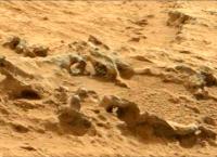
Posted by: EdTruthan Dec 9 2012, 08:10 PM
It's clearly something like that, a crust that formed around a relatively softer object... but, it's the near perfect oval shape of it that makes one wonder just what that softer object was.
Here's a cross-eyed view for those without R-B glasses...
http://www.edtruthan.com/mars/Sol121-122-Round-Formation-Cross-Eye-View.jpg
Posted by: nprev Dec 9 2012, 08:18 PM
A rock, obviously, or at least a clump of cohesive material. Almost looks like the remnants of same partially fill the hole.
Posted by: Fran Ontanaya Dec 9 2012, 08:36 PM
Thanks. The 2D images are deceiving, it seems flatter in them.
Posted by: serpens Dec 9 2012, 09:48 PM
I'm not sure anything is obvious about this feature. It is in a sedimentary deposit but was that aeolian or fluvial? Why was the raised circumference ridge more resistant than the surrounding material? Chemical influence or mechanical compression at the edge of a pothole? Teeny ejecta splat into unconsolidated sediment?
Posted by: Ant103 Dec 9 2012, 09:50 PM
Sol 122 Navcam pan :
http://www.db-prods.net/marsroversimages/Curiosity/2012/Sol122_pano.jpg
Posted by: ngunn Dec 9 2012, 10:16 PM
Doing statistics with a sample of one(!) we arrived right on top of this thing by chance so there must be more of them. Have we missed some, passed at a greater distance previously? If so, maybe they can be located in existing images. If not then perhaps this is a new kind of thing peculiar to the high thermal inertia unit. If that's the case there may be more of them ahead. There is definitely scope here for a moderately outlandish hypothesis but for the moment I'm completely stumped, sorry.
Posted by: CosmicRocker Dec 10 2012, 06:26 AM
Oh, boy, I love geological puzzles like this. Nice work with the imagery, Ed, as usual.
I'm sure we're not the only ones wondering about the origin of this feature. It will be interesting to see what is eventually published about it. After looking at the stereo imagery, it seems to me that the safest interpretation would be to assume that what we are seeing is part of a spherical structure embedded in the rock. It has a more durable outer crust and apparently a softer center.
Concretions are often spherical, though they are not normally isolated in an outcrop (speaking to ngunn's statistics of one comment). A mud bubble has been suggested, and I suppose that is possible; but I think it would be incredibly lucky for something as dynamic as a bubble to have been preserved so well as a fossil. Perhaps some sort of a dropstone or secondary impact fragment that became embedded in a sediment with a very different chemistry could have caused it to have become altered or to have formed some sort of reaction crust.
These are just a few thoughts coming off the top of my head as I look at these images. I'm sure some of you guys can come up with even more hypotheses.

edit: Has anyone tried to estimate the diameter of this feature? It would be interesting to know.
Posted by: CosmicRocker Dec 10 2012, 06:48 AM
Many of these rock slabs seem to have polygonal fractures in them. This appears to have been a relatively recent rock fall, but it is probably a typical example of the effects of aeolian erosion and thermal stresses breaking down the rocks on the surface.
Of course, the overhanging slab could have been whacked by a small impactor and we'd never know it. Or, I suppose even the small vibrations of the rover driving nearby could have been the straw that broke the camel's back, though there should be signs in the dust if that were the case.
Posted by: Antonb Dec 10 2012, 09:52 AM
If it is a relatively recent rockfall, would it fit the bill for a fresh broken surface to examine, as discussed earlier, or would the uncertainty about its age undermine any comparisons with the unbroken surfaces? It does seem to present an opportunity to compare the top surface (of the ledge) with the bottom (now top) and internal surface of the slab.
Posted by: Greenish Dec 10 2012, 03:10 PM
Some VERY rough math puts it around 10-12 cm across, I think (assuming the mast is vertical, etc...).
Posted by: ronald Dec 10 2012, 04:15 PM
... at least two:

|

|
Both also visible in the sol 122 hazcam http://mars.jpl.nasa.gov/msl-raw-images/proj/msl/redops/ods/surface/sol/00122/opgs/edr/fcam/FLA_408331341EDR_F0050938FHAZ00304M_.JPG.
Posted by: Phil Stooke Dec 10 2012, 05:44 PM
And another move, bubbles or no bubbles. This is a perspective view - near the ledge looking down into Yellowknife Bay.
Phil

|
Posted by: Ant103 Dec 10 2012, 06:48 PM
Sol 123 ("one, two, three, la la lalala" ) Navcam panoramic :
http://www.db-prods.net/marsroversimages/Curiosity/2012/Sol123_pano.jpg
And anaglyph. Yellow Knife is very close !
http://www.db-prods.net/marsroversimages/Curiosity/2012/Sol123_pano_ana.jpg
Posted by: Phil Stooke Dec 10 2012, 07:06 PM
and hey presto! - circular version.
Phil

|
Posted by: Stu Dec 10 2012, 07:35 PM
Interesting area... very bubbly...

|
Posted by: fredk Dec 10 2012, 08:49 PM
From back on sol 121, some more bubbly/ringy craziness:

|

|
Posted by: James Sorenson Dec 10 2012, 09:19 PM
Another one in the rearview mirror, with a couple other small ones next to it.
http://mars.jpl.nasa.gov/msl-raw-images/proj/msl/redops/ods/surface/sol/00123/opgs/edr/rcam/RLA_408419991EDR_F0051070RHAZ00307M_.JPG
Posted by: EdTruthan Dec 10 2012, 09:34 PM
Just saw those a while ago too James. Due the quantity and the consistently rounded nature of these objects it's easy to imagine the formation they're embedded was the muddy bottom of a water body, which through periodic floodings received these fluvially rounded stones, which then sank to the bottom, were covered by subsequent sedimentation, and afterward developed their encrustations by some interactive method between themselves and their substrate. That their original material was softer than their surrounding environment is clearly in evidence, so it makes sense that the heavier silts surrounding them might have easily permeated their outer skins quite easily under a bit of pressure. And of course their inherent softness would have contributed to how they became so well rounded to begin with. On the surface at least that seems to be the most terrestrially equivalent comparison. But this Mars, so anything goes...
Sol 123 - Rear Hazcam anaglyph view...
http://www.edtruthan.com/mars/Sol123-Rear-Hazcam-Anaglyph.jpg
...and a cross-eye close-up:
http://www.edtruthan.com/mars/Sol123-Rear-Hazcam-Bubble-Cross-Eye.jpg
Posted by: rob66 Dec 10 2012, 09:45 PM
|
|
|
|
And an un-eroded one just underneath (just down from center) ?! Looks beautifully spherical !
And is that scoop/scrape running top to bottom between the 'bubbles' and the rock ?
Posted by: ngunn Dec 10 2012, 10:28 PM
Not necessarily, the differential erosion could have been chemical. For example carbonate pebbles dissolved by later acidic water.
Posted by: Ant103 Dec 10 2012, 11:05 PM
You are so fast Phil
And my panoramic is updated with the downsampled frames (see my previous post).
Posted by: elakdawalla Dec 10 2012, 11:09 PM
The attached image happened to catch my eye today, an illustration to http://www.eurekalert.org/pub_releases/2012-12/mu-mao121012.php. I have no evidence that this is what Curiosity's seeing, but I show it because it's another kind of thing that can interrupt bedding in sediments -- not a dropstone, but a nodule that formed in place, I think. (Note that while the academic article concerns the search for evidence of microbial activity, the nodule shown here formed though an inorganic process. I think. Haven't read the article yet.)

|
Posted by: EdTruthan Dec 10 2012, 11:23 PM
Sol 121 Navcam - Upon close examination it's certainly tempting to think this object could be and intact "sphere" (or "bubble", whatever we're calling them). Hmmm. Look closely at it and you'll see three circles in near perfect triangular pattern. Did they hit this with a laser? (Actually looks like a bowling ball!) As for the soil disturbance question, it might be a compression artifact from the rover's weight having been on that rock, but in the full frame I don't see any track marks between the rover and the rock, though it's pretty rocky in the general area so they might not show...
http://www.edtruthan.com/mars/Sol121-Possible-Intact-Sphere-Anaglyph.jpg
...and a cross-eye view...
http://www.edtruthan.com/mars/Sol121-Possible-Intact-Sphere-Cross-Eye.jpg
Posted by: elakdawalla Dec 11 2012, 12:49 AM
Looks like the Martians have developed a game that combines Skee-Ball with Bowling. They must have tiny fingers though!
Thanks for keeping on top of the various occurrences of these curious features.
Posted by: atomoid Dec 11 2012, 02:42 AM
did everyone have one as a kid? http://t2.gstatic.com/images?q=tbn:ANd9GcRLmu14RWLE8obczOzAO6iu9rdjzeDV6tXNTcqB3KG57wQ2o2TEVw http://en.wikipedia.org/wiki/Kendama
Posted by: Eutectic Dec 11 2012, 04:19 AM
Although the rim thickness doesn't look right, the "mud bubbles" remind me of geodes, formed by in-situ processes involving groundwater or hydrothermal fluids.
Posted by: serpens Dec 11 2012, 05:41 AM
Or they could be as simple as a form of honeycomb weathering which would fit the oblongs. Perhaps chemcam will narrow the field.
Posted by: CosmicRocker Dec 11 2012, 06:10 AM
...............
Many thanks to everyone who pointed out the new imagery capturing additional examples of these structures; and kudos to all of you who noted the sol # of those images.
It's extremely helpful to know the sol # when you want to browse for additional images from the same area. Hopefully, in the next few days we'll get some nice mastcam images of these fascinating features. Higher resolutions and more colors will surely help us further characterize these things.
Posted by: dvandorn Dec 11 2012, 02:57 PM
They remind me, in many ways, of Pot of Gold, just more completely evacuated of the base rock (and a more complete decomposition of the indurated rind, leaving only that part protected by the proximity of the ground beneath it).
In most of the examples people have highlighted here, it looks like the base rock has been completely eroded away and the remnant rind is filled in with the same kind of soil or rock that covers the surrounding surface. However, in at least one example, it looks as if some of the base rock is still in place as crumbled-looking fragments -- that's the one that most reminds me of Pot of Gold. It also seems to be sitting up on top of the rock on which it sits and not as embedded in it as the other examples.
I'd be really interested in some ChemCam shots at something like that, where we could see if there's a difference between the base rock and the harder indurated rind.
-the other Doug
Edit -- here is the best view of the one I thought looked like it was sitting more on top of the surface, and where it looks a little like crumbles of the base rock might be sitting just inside the rind. It's the rearview mirror shot:
http://mars.jpl.nasa.gov/msl-raw-images/proj/msl/redops/ods/surface/sol/00123/opgs/edr/rcam/RLA_408419991EDR_F0051070RHAZ00307M_.JPG
Posted by: dvandorn Dec 11 2012, 03:12 PM
One other thought has occurred to me for the origin of these bubbles.
There seems to be a fair amount of agreement that the current surface has been deflated from previously-covering layers. We also know that Mars has a quite healthy impact flux.
Could these be remnants of small impact structures that were originally formed in a surface that has since been deflated, leaving only the small semi-spherical dyke of impact melt intact?
I admit, with a lot of these features occurring in the same surface horizon, you would have to posit a large number of relatively contemporaneous primary impacts into the now-deflated surface, and that does beg an explanation.
I've just learned that when you find any roughly circular structures on a surface that sees a significant impact flux, you need to at least consider an impact origin for them.
-the other Doug
Posted by: Phil Stooke Dec 11 2012, 04:27 PM
Another drive, perched right on the edge now. Update later.
Phil
Posted by: Ant103 Dec 11 2012, 05:36 PM
Right Phil
Navcam's panos of Sol 124 :
http://www.db-prods.net/marsroversimages/Curiosity/2012/Sol124_pano.jpg
Anaglyph :
http://www.db-prods.net/marsroversimages/Curiosity/2012/Sol124_pano_ana.jpg
Posted by: Phil Stooke Dec 11 2012, 05:55 PM
Here it is in circular form.
Phil

|
Posted by: Ant103 Dec 11 2012, 10:05 PM
So, Curisity has arrived at Yellowknife Bay. The Opportunity to celebrate it with a postcard, I think
http://www.db-prods.net/blog/2012/12/11/curiosity-arrive-a-yellowknife-bay/
Posted by: rob66 Dec 11 2012, 10:25 PM
http://www.edtruthan.com/mars/Sol121-Possible-Intact-Sphere-Cross-Eye.jpg
It looks like a scoop/drag to me - you can see a 'spoil heap' at the lower end of the trench.
Posted by: nprev Dec 12 2012, 03:09 AM
Uh, Damien...holy crap. Wow. Other superlatives. Wow. 
I really do feel like MSL is rolling on a long-dried-out riverbed from this shot. Let's see what the analyses tell us.
Posted by: Explorer1 Dec 12 2012, 08:42 AM
Looks like an inverse of Homeplate, at least from the macro perspective. A closer look will probably make this into a completely different place.
Posted by: Antonb Dec 12 2012, 09:24 AM
The bubbles remind me of these structures in the Navajo Sandstone:

|
The parallel between Moqui marbles and Mars blueberries has often been noted, but the shells they leave behind less so.
http://geology.utah.gov/online/pdf/pi-77.pdf, by Marjorie A. Chan and William T. Parry, gives a useful overview.
Posted by: ddan Dec 12 2012, 03:15 PM
|
|
Are those iron concretions?
Posted by: Antonb Dec 12 2012, 03:39 PM
Hematite (Fe2O3) - read the booklet I linked for an explanation of their formation.
Posted by: SteveM Dec 12 2012, 03:40 PM
Posted by: Phil Stooke Dec 12 2012, 04:06 PM
Now we are approximately here...
Phil

|
Posted by: ddan Dec 12 2012, 04:59 PM
I surmise that the science team has a good grasp on the formation and composition of the bubbles, since they did not stop for additional tests.
Posted by: Fran Ontanaya Dec 12 2012, 05:04 PM
I guess they would do a survey first before choosing what to look at in detail.
Posted by: djellison Dec 12 2012, 05:16 PM
How on earth do you reach that conclusion? Second guessing the science team is a game not worth playing.
We don't have ChemCam, APXS or any other analysis of them. They currently have a clear stated goal of getting to Yellowknife Bay for a first use of the drill.
These features will still be there if they warrant further attention on the way back out of Yellowknife Bay in a few weeks.
Posted by: Ant103 Dec 12 2012, 05:21 PM
Aaaaand, here we are ! Yellowknife Bay !
http://www.db-prods.net/marsroversimages/Curiosity/2012/Sol125_pano.jpg
Anaglyph version :
http://www.db-prods.net/marsroversimages/Curiosity/2012/Sol125_pano_ana.jpg
Posted by: Phil Stooke Dec 12 2012, 05:50 PM
Circular version of Ant103's new pan:
Phil

|
Posted by: ddan Dec 12 2012, 09:11 PM
You kind of alluded to it yourself.
Posted by: serpens Dec 12 2012, 09:52 PM
We don't have ChemCam, APXS or any other analysis of them. They currently have a clear stated goal of getting to Yellowknife Bay for a first use of the drill.
These features will still be there if they warrant further attention on the way back out of Yellowknife Bay in a few weeks.
Quite a reasonable conclusion from ddan assuming that the science team do basic risk and trade off analysis on observing features like this rather than blindly following a plan. (Actually a certainty rather than an assumption). To draw an analogy your approach would have meant that when Paso Robles was observed in Spirits 'rear view mirror' they should have kept going because the end goal was to climb the hill. Surely a robotic geologist should garner the approprite level of data from any anomaly before continuing on to a tasking which may, or may not, provide more significant information and which would force a scenario where they would have to retrace their steps rather than investigate new fields.
Posted by: Phil Stooke Dec 12 2012, 10:14 PM
Spirit went back to Paso Robles because it would not be seen again otherwise. They were not going back that way. But we know Curiosity will climb back out of Yellowknife Bay in a few weeks, so there's lots of opportunity to look at these things again soon, and maybe Shaler as well. Right now they want to be parked and with a solid work plan over the coming holiday period.
Don't forget that we might have ChemCam data on the pits already, as we can see now that we have on Shaler. We don't know yet. If they do and it's not very interesting there may be no need to stop. The point is, they know what they are doing!
Phil
Posted by: john_s Dec 12 2012, 10:17 PM
However Curiosity probably *will* retrace its steps, more or less- its ultimate goal is to the southwest, back the way we came. So it's reasonable to note things in passing, and decide whether to investigate them in more detail when we head back out.
John
[oops, overlapping reply with Phil's]
Posted by: Zelenyikot Dec 12 2012, 10:53 PM
I combined the thermal inertia http://www.nasa.gov/mission_pages/msl/multimedia/pia16159.html#, CTX and http://www.unmannedspaceflight.com/index.php?s=&showtopic=7442&view=findpost&p=195644. I think it will help us to make out the geology.

|
Posted by: djellison Dec 12 2012, 11:43 PM
Read my words again....where I explicitly state "These features will still be there if they warrant further attention on the way back out of Yellowknife Bay in a few weeks."
There will be no forced retrace. They're going that way anyway.
And I repeat - the assumption that an analysis has be done and they've decided to not look at these more closely is support by exactly zero data. We have no idea what the science team might or might not think of those feature. No idea at all.
Posted by: mhoward Dec 12 2012, 11:48 PM
Some nice sol 121 Mastcam images coming down. (A few of them seem out of focus, though.)
And at least one of the 'bubbles' has been imaged (sol 124), although only thumbnails down at the moment.

|

|
Posted by: stewjack Dec 13 2012, 12:21 AM
Thank you Zelenyikot. That graphic certainly makes things clearer for me. The red High Thermal Inertia signal seems to fit very nicely into the surface geology. Although it is not very apparent at our current location in Yellow Knife Bay.
Not a geologist,
Jack
Posted by: Ant103 Dec 13 2012, 01:47 AM
A WONDERFUL set of Mastcam34 & 100 have arrived. Can't wait tomorrow to stitch it into a mosaic (work done from my bed) !
Sol 120 beautiful layers, sharp as razor blades.
http://www.db-prods.net/marsroversimages/curiosity.html#81
And a detail at Sol 121 :
http://www.db-prods.net/marsroversimages/Curiosity/2012/Sol121_Mastcam100.jpg
Posted by: centsworth_II Dec 13 2012, 01:47 AM
To a http://mars.jpl.nasa.gov/msl/multimedia/images/?ImageID=4481 of the landing/Glenelg area and the likely route past the dunes to the base of Mt. Sharp (my green arrow approximation) I've inset Phil Stooke's route map (with a green arrow in the same direction as that in the larger map). If MSL drove toward Mt. Sharp along that green line from where it is now, it would never be more tha 100 meters from any location it has visited since sol 50. If it drove from the interesting area to the North of its current location along the blue line, it would drive past Jake Matijevic again.
Of course no one knows from where MSL will begin its trek to Mt. Sharp or the course it will take, but as has been pointed out, it is likely to to travel near to the route it has taken to Glenelg and could easily revisit a recently visited site.

|
Posted by: eoincampbell Dec 13 2012, 03:09 AM
And who knows what we'll see on the way to the base ... Mission planners could be wrestling as we type about this ...
Posted by: stewjack Dec 13 2012, 04:37 AM
Is that a mess of semi-rounded pebbles that I spy in the central region of Ant103's Mastcam 100 graphic. I guess it is possible they are just broken chips of the thin plates that have been rounded and smoothed somewhat by Aeolian action.
Posted by: Antonb Dec 13 2012, 08:37 AM
The focus is a little unsharp, but there's another 'bubble' (or concretion shell?), at the top of this Sol 123 Mastcam pic (cropped & tweaked from http://mars.jpl.nasa.gov/msl-raw-images/msss/00123/mcam/0123MR0767001000E1_DXXX.jpg).

|
Posted by: Ant103 Dec 13 2012, 11:28 AM
Sol 125 Navcam now in full 360°
http://www.db-prods.net/marsroversimages/Curiosity/2012/Sol125_pano.jpg
Posted by: algorimancer Dec 13 2012, 02:05 PM
http://www.edtruthan.com/mars/Sol121-Possible-Intact-Sphere-Anaglyph.jpg
...and a cross-eye view...
http://www.edtruthan.com/mars/Sol121-Possible-Intact-Sphere-Cross-Eye.jpg
A bit late to the party, but it wouuld be interesting to try zapping an intact spherule like this with the laser -- aside from perhaps id'ing the shell, could potentially quickly assess whether it is hollow, and if not, sample the filling material. Lot's of questions answered in one go. Then drive over it to fully fracture it and expose a pristine interior.
Posted by: Phil Stooke Dec 13 2012, 02:46 PM
Ant103's new full panorama in circular format. Spectacular location!
Phil

|
Posted by: xflare Dec 13 2012, 03:30 PM
Looks like some obvious cross bedding in this image from SOL 120
http://mars.jpl.nasa.gov/msl-raw-images/msss/00120/mcam/0120MR0752009000E1_DXXX.jpg
Posted by: fredk Dec 13 2012, 04:19 PM
And perhaps in this image too:
http://mars.jpl.nasa.gov/msl-raw-images/msss/00121/mcam/0121MR0757008000E1_DXXX.jpg
I still find it surprizing to see shadows without rgb colour fringes, like in this shot:
http://mars.jpl.nasa.gov/msl-raw-images/msss/00120/mcam/0120ML0753022000E1_DXXX.jpg
Posted by: Antonb Dec 13 2012, 04:29 PM
Reminiscent of Navajo sandstone:

|
(Cropped & reduced from http://hema.ipfw.edu/Geopics/Images/Geopics/Sediments/xbeds.jpg at The Department of Geosciences, Indiana University)
Posted by: Ant103 Dec 13 2012, 04:46 PM
Yep Fredk, this is one the joys of color CCD sensor
That was a little hard, but, the full 360° panorama in anaglyph
http://www.db-prods.net/marsroversimages/Curiosity/2012/Sol125_pano_ana.jpg
Posted by: Explorer1 Dec 13 2012, 05:58 PM
That discontinuity in the brightness of the rock in the middle Ant103's pan (around 3 o'clock in Phil's, just above the RTG); it that real or just an artifact? It looks incredibly straight.
Posted by: Phil Stooke Dec 13 2012, 06:21 PM
Artifact - a frame boundary.
Phil
Posted by: Ant103 Dec 13 2012, 06:35 PM
Yep, this is due to some gamma difference between one frame and the other. Since they've started to stretch Navcam images, you have this kind of weird effect in a panoramic.
Edit : finally, a color panoramic from the inside of the bay
http://www.db-prods.net/marsroversimages/Curiosity/2012/Sol125_Mastcam34.jpg
Posted by: rob66 Dec 13 2012, 08:42 PM
Sol 121 Slug

|
Posted by: Phil Stooke Dec 13 2012, 09:01 PM
Great picture! I like the way the wind-blown sand particles stick to the slug's slime trail.
Phil
Posted by: elakdawalla Dec 13 2012, 09:19 PM
Sigh...I got a worried email about Curiosity's "broken rear wheel" in http://mars.jpl.nasa.gov/msl-raw-images/proj/msl/redops/ods/surface/sol/00125/opgs/edr/ncam/NRA_408595089EDR_D0051398NCAM00313M_.JPG. Sir, what we have here is a dirt clod. (I mention it here in case this becomes a thing and we have to debunk the broken wheel story.)
Posted by: Hungry4info Dec 13 2012, 09:22 PM
The fact that it looked the same in both the left and right navcam imagery was a dead giveaway for that.
Posted by: iMPREPREX Dec 13 2012, 10:21 PM
Hey, folks. GigaPans of Sol 120 (Both MastCams).
34mm.:
http://gigapan.com/gigapans/119889
100mm:
http://gigapan.com/gigapans/119884
I have to manually download each image one at a time these days. But oh well - ain't no thing. And is the raw-image site being wonky or is it just me? Images aren't showing up as they used to. Some retrieval tool sites show images first. Then sometimes, the raw-image site has the images first.
|
|
Posted by: dburt Dec 13 2012, 10:48 PM
Yes it's cross-bedded, and the Navajo Sandstone (which I've seen a whole lot of here in Arizona) is also cross-bedded, but in detail (seen close-up) the resemblance is not that great. This rock seems to have a predominance of cross-beds at low angles, for one thing, and the grain size (and nature of the bedding too) seems too coarse and heterogeneous (unsorted) to have been deposited by the wind. Several other other types of geologic processes involving transport, deposition, and scouring by a fluid in motion (and wind is a fluid in motion) can also produce cross-bedding.
-dburt
Posted by: fredk Dec 13 2012, 10:55 PM
Could this (just below centre frame) be our first mastcam view of a "bubble":
http://mars.jpl.nasa.gov/msl-raw-images/msss/00109/mcam/0109MR0685077000E1_DXXX.jpg
This was from the Bell Island location, and we first noticed the "bubbles" in navcam from the 121 location, but perhaps they are still similar formations?
Posted by: Phil Stooke Dec 14 2012, 12:36 AM
Looks like you're right, Fredk. That gives a good view of the 'shell' - some MAHLI images of one would be really nice now. I don't notice any on this bottom level of the depression.
Phil
Posted by: exoplanet Dec 14 2012, 03:21 AM
Has hematite been found here in high concentrations
through any of the past observations? Looking forward to more discussion.
Posted by: CosmicRocker Dec 14 2012, 07:05 AM
Excellent, that's just what I was waiting for. It would be nice to get a few more mastcam shots, and hopefully some MAHLIs, as Phil noted.
Posted by: serpens Dec 14 2012, 07:28 AM
If these are a martian version of cannonball concretions (and that is just one of a number of possibilities) then the easily eroded interior and more resistant shell would imply a change in the accretional environment. But even if they are concretions I don't think there is any reason to attribute the cementing agent to hematite.
Posted by: James Sorenson Dec 14 2012, 08:01 AM
I can see how decieving that image might show, but here is another view of the wheel rotated. As Emily said its just a clod. Broken wheel debunked. No worries.
http://mars.jpl.nasa.gov/msl-raw-images/proj/msl/redops/ods/surface/sol/00124/opgs/edr/ncam/NLA_408511795EDR_F0051216NCAM00436M_.JPG
Posted by: Zelenyikot Dec 14 2012, 11:11 AM
Interesting light solid (sol 123). What can it be?

|
Posted by: Ant103 Dec 14 2012, 12:45 PM
Sol 121 Mastcam100 mosaic now complete. But a strange effect with some of the top pictures out of focus.
http://www.db-prods.net/marsroversimages/Curiosity/2012/Sol121_Mastcam100-2.jpg
Posted by: acastillo Dec 14 2012, 03:13 PM
Wow! Looks like some beautiful cross-bedding, especially on the outcrop in the middle.
Posted by: Stu Dec 14 2012, 04:26 PM
Fred's well-spotted "Half Dome" (right) and another one nearby, both enhanced to bring out details...
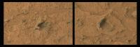
|
Posted by: ronald Dec 14 2012, 05:15 PM
From sol 114:
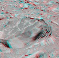
|
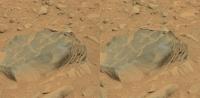
|
Whatever it is composed of - visually the fine shine let it look like soapstone.
Posted by: Ant103 Dec 14 2012, 05:54 PM
Thank you ronald for these stereoscopic view.
I'm adding a color anaglyph, and so it's complete
http://www.db-prods.net/marsroversimages/Curiosity/2012/Sol114_ML_R_ana.jpg
Posted by: Phil Stooke Dec 14 2012, 07:13 PM
Chemcam mosaic, sol 126 - it's getting hard to distinguish this from the MIs at Endeavour.
Phil
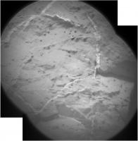
|
Posted by: mhoward Dec 14 2012, 07:16 PM
It isn't just you. View-by-sol on the raw images pages still isn't reliably showing all images right away. For example, right now http://mars.jpl.nasa.gov/msl/multimedia/raw/?s=126 shows two ChemCam images while http://mars.jpl.nasa.gov/msl/multimedia/raw/?s=126&camera= shows five. It might correct itself after a while. But this has already been discussed in the Image Retrieval Tools thread, and further discussion of it should probably go there (just wanted you to know you're not imagining things). I think a simple workaround is to view by instrument.
Posted by: dburt Dec 14 2012, 08:22 PM
What I can't help noticing exposed in the block in the center is a beautiful example of a disconformity (erosion surface, caused by scouring) between the cross-bedded coarse-grained material on top (what I was commenting on in #259 above) and likewise cross-bedded, but uniformly fine-grained material on the bottom. In terms of transport environments, the beds on top represent a relatively high-energy environment, able to move the larger, darker grains, and the beds on the bottom represent a relatively low-energy environment, where only lighter dust or fine sand grains could be moved. The nature of the fluid involved in this transport is open to debate.
-dburt
Posted by: acastillo Dec 14 2012, 09:13 PM
Good observation about the disconformity. These morphologies certainly seem to agree with this being at the tail end of an ancient alluvial fan, possibly emptying into a lake. Given the relatively small thickness of the beds and the low angle of the cross-bedding, it argues for water being the transporting fluid. This contrasts with the classical wind-driven cross bedding example on Earth, the Navajo sandstone, which you referred to in your post #259. If my memory is correct, the thickness of the cross-bedding in the Navajo sandstone is on the order of tens of meters to hundreds of meters, much larger than what we are seeing here on Mars.
Posted by: dburt Dec 15 2012, 12:07 AM
Not necessarily, as I explained in great detail here on UMSF over 5 years ago, and in publications with Paul Knauth and Ken Wohletz earlier. Very similar surface rocks with identical bedding features were imaged by the two rovers Opportunity and Spirit and were attributed to a variety of fluids, including water, wind, and volcanic gas. I suggested all could easily be blast beds, resulting from distant impacts. You can consult those references for details. The debate may still be open after 5 years, but not on these pages PLEASE.
-dburt
Posted by: Actionman Dec 15 2012, 12:11 AM
Good eye good eye nice find.
I cut and color adjusted this from the adjacent image 0123MR0767000000E1.
So what is the white material?
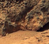
|
Posted by: serpens Dec 15 2012, 12:42 AM
Well the Meridiani sandstone layers are hundreds of metres thick and for height (= depth) of sedimentary structures Mount Sharp leaves all in its wake. Curiosity will no doubt narrow down the options for deposition in this area but in the interim nothing can be taken for granted despite the pretty strong indications that these beds are associated with the fan. I mean the disconformity could be scour, or a deflationary surface followed by a energetic depositional process, or it could even be a sequence boundary (drowning unconformity) or a change in fluid etc.
Posted by: Phil Stooke Dec 15 2012, 04:08 AM
We just had another move towards the rocks, probably positioning for a first test drill. Very rough position:
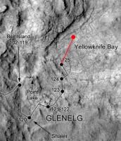
|
Phil
Posted by: Zelenyikot Dec 15 2012, 05:34 AM
Colored Chem Cam, sol 117
Now complete
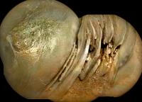
|
Posted by: Stu Dec 15 2012, 09:01 AM
Lovely place...
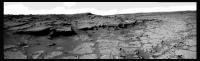
|
Posted by: Ant103 Dec 15 2012, 09:54 AM
B-b-but ? What have you done with the sky Stu ??
Sol 127 Navcam pan :
http://www.db-prods.net/marsroversimages/Curiosity/2012/Sol127_pano.jpg
Posted by: Stu Dec 15 2012, 10:08 AM
??Just wanted to isolate the rocks in the foreground, Ant, they're so dramatic. I'm rubbish at skies anyway!
Posted by: Phil Stooke Dec 15 2012, 02:43 PM
Ant103's partial pan in circular form.
Phil

|
Posted by: acastillo Dec 15 2012, 09:03 PM
Absolutely beautiful! This has to be the most geologically diverse landscape we've seen on Mars yet. I can imagine how excited the project scientist are right now.
Posted by: ronald Dec 15 2012, 09:35 PM
False color image from sol 122:

|
A combination of http://mars.jpl.nasa.gov/msl-raw-images/msss/00122/mcam/0122MR0764008000D1_DXXX.jpg, http://mars.jpl.nasa.gov/msl-raw-images/msss/00122/mcam/0122MR0764009000D1_DXXX.jpg, http://mars.jpl.nasa.gov/msl-raw-images/msss/00122/mcam/0122MR0764013000D1_DXXX.jpg and the http://mars.jpl.nasa.gov/msl-raw-images/msss/00122/mcam/0122MR0764007000E1_DXXX.jpg.
I think the redshift in the outer corners is due some vignetting issues.
Posted by: Airbag Dec 15 2012, 09:57 PM
Some partial sol 121 MastCam 34 panoramas came down today.
Airbag

|
Posted by: Airbag Dec 15 2012, 09:58 PM
...and another one.
Airbag

|
Posted by: elakdawalla Dec 16 2012, 12:48 AM
Get comfy here. They said at today's Planetary Radio Live event that drilling likely won't begin until after the holidays, and that the whole process may take 1-2 months.
Posted by: Airbag Dec 16 2012, 02:39 PM
Some Sol 111 MastCam100 images arrived; looking back at Rocknest and tracks.
Airbag

|
PS Does anybody have a good flat field for the MC100 please? I've messed around with some based on partial and full sky (gradient) images but have not been able to create one that works well for all images in terms of even image brightness.
Posted by: Stu Dec 16 2012, 04:31 PM
So many rocks all jumbled up together, scattered in all directions, easy to just "speed read" an image without taking any of it in. But when you isolate some of the rocks from the images, picking out those with different shapes, textures, weathering and form, it reveals what a truly fascinating place Gale Crater is, and you can't help wondering "What happened here? What made this landscape looked this way? Why does that rock look like that? What's that rock's story..?"

|
Posted by: James Sorenson Dec 16 2012, 06:23 PM
Not as good as Damien's work, but here is the Sol-106 Mastcam 360 pan.
I decreased the resolution on this alitte bit for upload to flickr.
http://www.flickr.com/photos/43581439@N08/8278586366/
And a Polar:
http://www.flickr.com/photos/43581439@N08/8277706895/
Posted by: James Sorenson Dec 16 2012, 07:16 PM
The Sol-36 Mastcam skyflats are the most recent I believe, someone correct me if I'm wrong. That's what Ive been using.
http://mars.jpl.nasa.gov/msl/multimedia/raw/?s=36&camera=MAST_
Posted by: mhoward Dec 16 2012, 07:56 PM
Lots of arm work on sol 129. Some crazy MAHLI images coming down. Veins? (Edit: You're right, Phil; getting hard to tell this from Endeavour.)
http://mars.jpl.nasa.gov/msl-raw-images/msss/00129/mhli/0129MH0075001000E1_DXXX.jpg
http://mars.jpl.nasa.gov/msl-raw-images/msss/00129/mhli/0129MH0075001001E1_DXXX.jpg
(The raw images site seems to be struggling at the moment, so patience may be required, although these direct links should work.)
Posted by: Mars Attack Dec 16 2012, 08:32 PM
Does anyone know the status of the brush on the turrent, when it will be cleared for use? It would be interesting to use it on the above rock to see if the white veins shown are also hidden beneath the dusty areas in the MAHLI pictures that just came down.
Posted by: Doc Dec 16 2012, 10:02 PM
http://mars.jpl.nasa.gov/msl-raw-images/msss/00129/mhli/0129MH0075001000E1_DXXX.jpg
http://mars.jpl.nasa.gov/msl-raw-images/msss/00129/mhli/0129MH0075001001E1_DXXX.jpg
My, my... whatever have we here?
Posted by: Gerald Dec 16 2012, 10:05 PM
Thanks Emily, thanks Fred, for being wellcome!
Parts of the Sol 121 Mastcam 100 images look to me pretty much like some abraded rock, almost parallel to its layering. So, very thin layers become visible.
To be able to distinguish fine details I tried to ad-hoc do some extreme false colouring of a rectangular region of Ant103's stitched image of that sol (see post #239).
The following images show, which region was chosen within the stitched image,

|
then the chosen region,

|
and finally a false colour version of the chosen region modified with means of consumer image processing software.

|
Colours were not chosen explicitely for individual features, but calcultated by appropriately chosen color space transformations and contrast enhancement operators.
Varying analysis results of ChemCam, or of the drill, with depth of the drill hole might find a visual correspondence with such thin layerings.
Posted by: ronald Dec 16 2012, 10:26 PM
Seeing http://mars.jpl.nasa.gov/msl-raw-images/msss/00129/mhli/0129MH0075001001E1_DXXX.jpg I would say the http://mars.jpl.nasa.gov/msl-raw-images/msss/00128/mcam/0128ML0522000000E1_DXXX.jpg was allready in use.
Edit: Ahh - maybe totally wrong

Powered by Invision Power Board (http://www.invisionboard.com)
© Invision Power Services (http://www.invisionpower.com)