Printable Version of Topic
Click here to view this topic in its original format
Unmanned Spaceflight.com _ Opportunity _ From Cambridge Bay to the "parking lot"
Posted by: Tesheiner Aug 31 2010, 08:19 PM
Bye bye, Cambridge Bay. It's roving time once again.
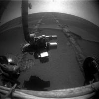
No navcams (yet), but this hazcams from sol 2347 tells us that we are back on the road.
http://qt.exploratorium.edu/mars/opportunity/forward_hazcam/2010-08-31/1F336547569EFFAO1RP1205L0M1.JPG http://qt.exploratorium.edu/mars/opportunity/rear_hazcam/2010-08-31/1R336547620EFFAO1RP1301L0M1.JPG
Still have to confirm it visually but according to the "telemetry" this drive was 85+ meters east.

Posted by: SFJCody Aug 31 2010, 11:48 PM
I felt sure they were going to stay there a little while longer. I guess it's time to get moving again. I'm not complaining! 

Posted by: SFJCody Sep 1 2010, 12:00 AM
I think they're now at about the same longitude as Duck Bay.
Posted by: ngunn Sep 1 2010, 10:47 AM
Since it's now in the thread title could somebody remind us exactly which area is being referred to here as the parking lot. Googling around I find that several different parts of Meridiani have been so described.
I know - I've not been paying attention  - but newcomers might welcome clarification too. Is it the large patch of exposed bedrock ahead, the smooth plain beyond, or both?
Posted by: jamescanvin Sep 1 2010, 11:51 AM
My understanding (and what I've meant when using it myself) is that the 'parking lot' is the smooth plain after the bedrock ahead. Essentially the large green region on the right of http://www.unmannedspaceflight.com/index.php?s=&showtopic=6623&view=findpost&p=163133.
So this thread will cover the next ~2km east across the bedrock. Then, hopefully in the not too distant future, we'll start another for the 2km dash across the parking lot to Santa Maria. 
James
Posted by: BrianL Sep 1 2010, 12:00 PM
I would prefer it if we continued using tarmac. The last thing we want is for Oppy to park itself.
Posted by: Tesheiner Sep 1 2010, 12:24 PM
My first idea was to name the thread "From Cambridge Bay to Santa Maria" but then I thought the crater would be too far away to cover the distance without another "science stop" in the middle.
---
Now checking tosol's imaging plan ... it's driving day. Hope for another 80+ meters.
Posted by: ngunn Sep 1 2010, 02:58 PM

Thanks. I think I was confusing pavement with parking lot. People do this all the time in Wales, especially during the tourist season.
Posted by: brellis Sep 1 2010, 07:42 PM
@ngunn - there must be some jokes about stale bread and overcooked meat in there too?
Posted by: Tesheiner Sep 1 2010, 08:47 PM
Today is sol 2348 and we're 40m closer...
Posted by: Stu Sep 2 2010, 03:42 PM
Am I right in thinking we're now just slightly less than 10km from Cape York? Will be great to be in single figures!
Posted by: Tesheiner Sep 2 2010, 05:18 PM
If we take a straight line to Santa Maria and another one to Cape York, yes.
Obviously, the odometry will be much more but that's another story.
Posted by: Stu Sep 2 2010, 05:21 PM
Yeah, very true. I was thinking more of an "emotional" 10km rather than a physical one
Posted by: ElkGroveDan Sep 2 2010, 06:51 PM
I prefer to think of it as 6.2 miles. The smaller number sounds better.
Posted by: charborob Sep 2 2010, 07:23 PM
For a smaller number, we could say that we're just over 2 leagues away. (BTW, a league being the distance a person can walk in an hour, does it mean we should be there in a couple of hours?)
<ducks>
Seriously, the official Opportunity traverse map for sol 2286 (http://marsrovers.jpl.nasa.gov/mission/tm-opportunity/opportunity-sol2286.html) has a progress bar showing that 8km has been covered out of 19km, meaning there was 11km to go. On sol 2341, 1,24 km more had been added to the total, so, yes, I guess we're under 10 km away (depending on the twists and turns to come).
Posted by: redmoon Sep 2 2010, 07:49 PM
From the last Planetary Society Update:
"...Were six miles away [9.65 kilometers] and we can see the thing, and its made everybody that much more excited and eager to make it there, said Maxwell.
http://www.planetary.org/news/2010/0831_Mars_Exploration_Rover_Update_Spirit.html
Posted by: climber Sep 2 2010, 07:50 PM
Obviously, the odometry will be much more but that's another story.
...and we've crossed the 10 km ODOMETRY from Victoria on last drive...
Posted by: alan Sep 2 2010, 09:13 PM
Half way there, that means we should arrive in (ducks) 
July 2012, a month before MSL reaches Mars.
Go Oppy Go
Posted by: NW71 Sep 2 2010, 10:19 PM
Loving the stat fest that is going on on this thread at the minute so I thought I would add my stat of the day!
On the assumption that Charborob's figures are correct (and why shouldn't they be) then we are only 260m from the halfway point on the projected travel path between Victoria and Endurance.
Go Oppy!
Neil
Posted by: CosmicRocker Sep 3 2010, 05:38 AM
In keeping with the "teach a man to fish" theme we saw last month, we should point out that Google Earth/Mars has a very useful http://earth.google.com/support/bin/answer.py?hl=en&answer=148134 that, in conjunction with Eduardo's excellent KML route map, can be used to easily and accurately measure all sorts of distances along Opportunity's route, and elsewhere. Using it, I measured 9.65 km from the sol 2348 location to near Cape York following the proposed route line; the same distance quoted in the Planetary Society Update. 
Posted by: Stu Sep 3 2010, 05:56 AM
Yep, and that's exactly the tool I used to reach my "slightly less than 10km" figure, CR, as my blog says...
Hadn't actually read the latest MER Update all the way through until earlier today. That would have saved me some time, I guess! 
Posted by: centsworth_II Sep 3 2010, 06:32 AM
Working on a new record here for number of posts between Opportunity Route Maps.
Posted by: Stu Sep 3 2010, 06:38 AM
...and thanks for contributing to the record attempt
Posted by: Tesheiner Sep 3 2010, 07:27 AM
Here's the latest navcam mosaic, taken during sol 2349 after a 80+ meters drive.

|
We can see right ahead (10 meters?) traces of the rocky pavement which will be the rover's path for the next 1.5km. It's time to say "good bye" to the sea of dunes.
Posted by: Stu Sep 3 2010, 10:27 AM
I thought it might be interesting to see what the ground ahead is actually like for our gal, so here's a pic showing HiRISE views - all to the same scale - of (on the left) the terrain we've been driving across recently and, on the right, 1) the terrain we'll be driving across once we get off "the Pavement", and 2) the terrain we'll be crossing once in "The Parking Lot". Note: Of course, these are just quick look samples, there'll be smoother and rougher areas, and this is just for fun, but I still thought it was quite interesting to see them side by side...

|
Posted by: Mirek Sep 3 2010, 03:50 PM
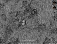
Possible multiple (6-7?) crater approx. 1 km ESE from Opportunity current position.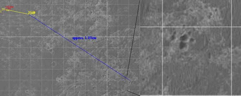
Posted by: Tesheiner Sep 3 2010, 04:20 PM
Or eight! Here's a better image taken from GE.
|
And what a coincidence. I saw the group some time ago and I'm actually using it as a "control point" (named "Triplet") for my tool which automatically generates the KML version of the route map. These "control points" are used to interpolate/extrapolate the lat/long coordinates of the actual route points.
Posted by: Stu Sep 3 2010, 04:34 PM
(leans over from the back seat)
Oh wow! Can we go there? Can we? can we? Can we?
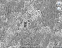
Posted by: Mirek Sep 3 2010, 04:40 PM
Reminds me of Morasko (Poland) set of 7 craters: http://en.wikipedia.org/wiki/Morasko_meteorite_nature_reserve

Posted by: Stu Sep 3 2010, 05:41 PM
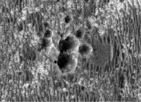
... and just to give a sense of scale, here's "Oppy" (scale correct, it's cloned from the same HiRISE image) next to the craters...
|
Posted by: Mirek Sep 3 2010, 06:22 PM
Great Stu. Comparing the sizes gives you the sense of how thin is Mars' atmosphere to allow creation of group of such small craters.
I wonder if the fact that parent body of that crater group broke up/exploded before impact would mean there is gonna be (or was in the past) a large number of meteorites on the ground.
Posted by: Burmese Sep 3 2010, 06:42 PM
*glances at Scott's blog*
When was the last time Oppy drover over 100m?
Posted by: MoreInput Sep 3 2010, 06:47 PM
Hey, it is just a marsian cat paw. It reminds me of the footsteps of a giant cat.
So we could name them "cat paw crater"?

|
Posted by: Hungry4info Sep 3 2010, 07:03 PM
I think the last time the rover drover over 100 m was on its way to Victoria.
Posted by: Poolio Sep 3 2010, 07:27 PM
Actually, the last time she topped 100m was on sol 1954 while she was backtracking to Block Island. I have the very specific figure 107.48 recorded in my ongoing spreadsheet, but I don't know where that came from now. The official http://marsrovers.nasa.gov/mission/status_opportunityAll_2009.html#sol1954 for that sol states simply that it was "over a 100 meter (328-foot) drive".
She also drove 137 meters on sol http://marsrovers.nasa.gov/mission/status_opportunityAll_2009.html#sol1859 while blazing past Porcupine.
EDIT: Found it. The 107.48 came from A.J.S. Rayl's Planetary Society http://www.planetary.org/news/2009/0731_Mars_Exploration_Rovers_Update_Spirit.html for July 2009.
Posted by: algorimancer Sep 3 2010, 07:35 PM
|
|
I think those are mounds. Compare the lighting with that on the dunes. Of course, how the mounds came to be is another matter.
Posted by: BrianL Sep 3 2010, 08:00 PM
If they were mounds, would they not be lit on the same side as the dunes? 
Posted by: Phil Stooke Sep 3 2010, 08:09 PM
That's a very common optical illusion with planetary images. But no, they actually are craters!
Phil
Posted by: ElkGroveDan Sep 3 2010, 08:18 PM
Save the image to your computer and then rotate it 90 and 180 degrees. Your mounds will become craters again.
Posted by: Mirek Sep 3 2010, 11:21 PM
I actually tried to force my brain to see mounds and I couldn't, so the illusion works both ways.
My eyes hurt now... 
Posted by: CosmicRocker Sep 4 2010, 04:05 AM
What do you mean they aren't mounds?
|
Posted by: Bobby Sep 4 2010, 04:11 AM
As we keep dropping in elevation. At our current position. Are we lower then the bottom of Victoria Crater yet and would any exposed bedrock we drive upon now be the layers that might be at the bottom of Victoria???
I would say our next stop for investigation will be the group of small craters we are heading for.
Posted by: CosmicRocker Sep 4 2010, 05:44 AM
Bobby: As best as I can tell, the lowest point inside Victoria Crater is -1451 meters below the Mars datum. That's from the Google Mars model, which, as we have seen, has some problems with the real Mars. Opportunity's current location would appear to be somewhere around -1385 meters in the same model...quite a few meters above the lowest apparent point inside Victoria. Shortly after Oppy passes Santa Maria she'll be at an elevation near to the bottom of Victoria.
As for your bedrock layers question, that is more difficult to answer. It depends on whether those layers are perfectly flat, or if they are tilting in one direction or another.
Posted by: ngunn Sep 4 2010, 07:41 AM
I don't think that's right. This map shows a moderate slope of several hundred metres going down into the crater from the relatively level parking lot: http://www.unmannedspaceflight.com/index.php?act=attach&type=post&id=20806
Posted by: CosmicRocker Sep 5 2010, 03:39 AM
Sorry, ngunn. I don't understand your point. According to the Victoria Crater DEM, the lowest point inside the crater is about -1450 meters. On the map you cite, the -1450 contour crosses the future route path about 1 kilometer SE of Santa Maria. At that point Opportunity will be at the same elevation as the bottom of Victoria Crater. If the bedrock layers are actually horizontal across this region, then Oppy may be driving on the same layers of rock as would be found at the bottom of Victoria.
Posted by: ngunn Sep 5 2010, 07:40 AM
Well I'm just looking at that map, nothing else, and I see a labelled contour at -1700 inside the crater and contours descending for another 40 metres beyond that to the edge of the map. I can't explain the mismatch with your other information but I guess understanding where it comes from would be useful, and knowing this place it will be provided.
Posted by: centsworth_II Sep 5 2010, 07:47 AM
The question is when will Opportunity be at the same elevation as the bottom of Victoria Crater. not Endeavour.
Victoria Crater elevations from http://www.lpi.usra.edu/meetings/lpsc2008/pdf/1878.pdf
|
Posted by: Stu Sep 5 2010, 07:50 AM
Lovely layered rock...

|
Posted by: ngunn Sep 5 2010, 07:51 AM
Right. sorry!
Posted by: brellis Sep 5 2010, 11:33 AM
@centsworth - Thanks for the link to the paper on Victoria. It brings back a Q I had then about Oppy's dip into Victoria: did we get deep enough to answer prevalent questions or not? IIRC we turned back when she had a problem with either voltage on a wheel or her shoulder got stiff?
Anyway, it'd be amazing and wonderful to get the rest of the evidence desired in the bottom of Victoria many kilometers down the road!
Posted by: Floyd Sep 5 2010, 01:17 PM
Centsworth_II
This discussion seem to have missed the discussion and answer posted by Emily in the Distant Vistas thread.
Posted by: centsworth_II Sep 5 2010, 04:05 PM
Right. http://www.unmannedspaceflight.com/index.php?s=&showtopic=6438&view=findpost&p=163590 that Emily posted shows about 800 meters straight line horizontal distance between Santa Maria and where the elevation again matches that at the bottom of Victoria. (I've indicated this in green.)
Edit: Although if you take the elevation of Victoria's bottom
as being -1450 rather than -1440 as indicated in the table, the straight line distance is more like 1900 meters.

|
Posted by: SFJCody Sep 6 2010, 01:05 AM
2353 looks like a driving sol. I wonder if this is the +100m drive mentioned on Scott Maxwell's twitter. If it is 100m, it will cut 1% off the distance to Endeavour in a single sol!
Posted by: CosmicRocker Sep 6 2010, 04:44 AM
To close the loop, this is a screen grab of one of the maps I used to determine the elevation at the bottom of Victoria. It is a contour map derived from a Hirise DEM. It is one of several files I plucked from a NASA server, somewhere. The lowest contour is -1450 m.
|
Of course, the actual bedrock beneath Victoria's bottom will be some distance below the infilling dunes.
Posted by: Bobby Sep 6 2010, 04:33 PM
Thanks for the debate regarding the elevation where we are at now. I've also noticed one thing about this area compared to the area before Victoria Crater. Where have all the mini craters gone? The ones we saw on the dunes that were a foot wide?
Posted by: BrianL Sep 6 2010, 06:30 PM
I recall seeing a very small one in a ripple just a few sols ago, although I would never be able to find it again.
Posted by: Tesheiner Sep 7 2010, 03:06 AM
The drive was executed but it wasn't 100m. Actually it was ... 110m!!!
Pedal to the metal!
Posted by: elakdawalla Sep 7 2010, 03:58 AM
Go Oppy go!!!
Posted by: ElkGroveDan Sep 7 2010, 04:02 AM
Hey slow down team or we'll miss our exit.
Posted by: Syrinx Sep 7 2010, 06:43 AM
That's incredible. I'm pretty sure Oppy drove further than I walked today.
Of course, I probably ate more BBQ than Oppy. Probably.
Posted by: Poolio Sep 7 2010, 11:52 AM
Wow! Fantastic progress. These sorts of drives may become more the norm than the exception as the terrain improves, without those pesky ripples to "freak out" the rover.
We are now east of Cape Agulhas. The last time Oppy was this far east was on sol 1186.
(Syrinx: that was one of the funnier things I've read in a while.)
Posted by: Bobby Sep 7 2010, 12:44 PM
110 meter??? WoW Keep Going Oppy.
Posted by: fredk Sep 7 2010, 06:21 PM
From http://twitter.com/marsroverdriver/status/23248306228
Posted by: MoreInput Sep 7 2010, 06:40 PM
If no one said it yet, I say it now and loud: "Are were there yet ! Are were there yet ! "
Posted by: Tesheiner Sep 7 2010, 07:48 PM
I think you won't have that much time. Until the end of the year, perhaps.
Posted by: Tesheiner Sep 7 2010, 08:51 PM
Playing around with Goggle Earth I found what looks like another contact layer similar to Cambridge Bay right in the planned path. My 2cents that we will stop for a few sols right there next week.

|
Posted by: SFJCody Sep 8 2010, 06:05 AM
You may be right. They're driving again on 2355... I guess the wheel currents are behaving themselves.
Posted by: Tesheiner Sep 8 2010, 06:53 AM
I hope so; it would be great to hear something from tweeter.
Meanwhile, here's a polar view of the current site made from the navcams from sols http://qt.exploratorium.edu/mars/opportunity/navcam/2010-09-06/ and http://qt.exploratorium.edu/mars/opportunity/navcam/2010-09-07/. Bedrock everywhere.

|
Posted by: jamescanvin Sep 8 2010, 07:27 PM
Sol 2353 Drive Direction Mosaic
http://www.nivnac.co.uk/mer/index.php/b2353
James
Posted by: NW71 Sep 8 2010, 08:30 PM
Interesting tweet from Scott Maxwell about 4 hours ago;
"We're past the halfway mark to Endeavour!"
Go Oppy!
Neil
Posted by: Sunspot Sep 8 2010, 08:51 PM
Why has the clock on the MER website become so out of sync?
Posted by: fredk Sep 8 2010, 11:41 PM
Interesting trivia from http://twitter.com/marsroverdriver/status/23943246607
Posted by: ElkGroveDan Sep 8 2010, 11:51 PM
Show offs. Next they'll say they did it with one arm stowed behind her back.
Posted by: Stu Sep 8 2010, 11:51 PM
Interesting structure in the rocks...

|
Posted by: brellis Sep 9 2010, 06:42 PM
A http://www.space.com/scienceastronomy/mars-rover-halfway-endeavour-crater-100908.html marking the halfway point to Endeavour had a couple of interesting points:
"They're a kind of mineralogical marker bed for places with biological potential," Golombek told SPACE.com. "So that's our ultimate goal, to get to them."
In fact, NASA's next Mars rover, the car-sized Curiosity, will prioritize looking at clays. The rover is scheduled to launch in November 2011 and land on Mars in August 2012. All of its potential landing sites sport clays similar to those found on Endeavour's rim, Golombek said.
This brings back the topography issue -- assuming there were large bodies of water, would the elevation at the rim of Endeavour be a 'sea level' towards which Oppy is gradually descending?
The article then raises a troubling point that seems incorrect:
Still, there's no reason to think Opportunity won't make it, he said. The rover is in pretty good shape, besides a broken right front wheel that doesn't turn. For that reason, engineers are driving it backward, but that shouldn't pose a problem.
I thought it just had a voltage spike in Victoria?
Posted by: paxdan Sep 9 2010, 07:00 PM
The wheel rotates on its axle just fine, however, it cannot be steered.
Posted by: stevesliva Sep 9 2010, 07:01 PM
It doesn't "turn" in the steering sense, right? It rolls.
Posted by: djellison Sep 9 2010, 08:49 PM
It can drive, but it can not be turned for steering. They have seen slightly elevated currents on it for years - they just need to keep an eye on it and not do anything that makes that situation worse.
Posted by: BrianL Sep 9 2010, 10:16 PM
With the commitment to backward driving, it will be interesting to see if the LR wheel (the new RF wheel) develops elevated currents at some point. And then what do they do?
Posted by: brellis Sep 9 2010, 11:41 PM
Start break dancing!
Seriouserly, thanks for the refresher on the wheel issue. So, if they stop and roll around a site for science reasons, that could be a point when a stiff wheel might cause a bit of a drag on the process.
Posted by: Tesheiner Sep 10 2010, 08:08 AM
There were no nav/pancams after yestersol's drive but they were shot today. This is not usual but in this case I think it was due to lack of time since the drive ended close to the UHF uplink time and if the mosaics were taken the uplink window would be lost.
Here's the navcam mosaic shot on sol 2356 in polar view. I used it to update http://www.unmannedspaceflight.com/index.php?s=&showtopic=681&view=findpost&p=163926.

|
Posted by: Poolio Sep 10 2010, 12:03 PM
Says here that the "second longest backward drive ever" was http://marsrovers.nasa.gov/mission/status_opportunityAll.html#sol23349. Backward autonav has been applied eight times now for a total of about 158 meters. Not bad! Distances driven in excess of 70 meters (approximate): 7, 10, 11, 15, 16, 23, 35, 41.
Posted by: Vultur Sep 10 2010, 01:01 PM
Awesome! Go Oppy!
Posted by: jabe Sep 10 2010, 01:21 PM
ok..newbie question involving google mars..any way of adding some higher resolution pictures so when you zoom in you can see the terrain better?
jb
Posted by: Phil Stooke Sep 10 2010, 01:32 PM
Read backwards and you'll find out how to do it - but maybe this needs to be in a little FAQ at the top of the forum!
Phil
Posted by: fredk Sep 10 2010, 03:04 PM
I don't see any reference to the second longest backward drive at that link.
Posted by: Floyd Sep 10 2010, 03:16 PM
That was actually on Scotts Tweet Sept 8th
"This past weekend's drive was longest backward drive ever. (Not longest *drive*, but longest *backward*.) Yesterday's was second-longest"
Posted by: Tesheiner Sep 10 2010, 03:29 PM
jb
The instructions to get them are on the route map itself. Just click on the map name on the left toolbar.

|
Posted by: Stu Sep 10 2010, 04:37 PM
Scott Maxwell was kind enough to answer some questions for me for a post on my "Road to Endeavour" blog, if anyone wants a look...
http://roadtoendeavour.wordpress.com/2010/09/10/halfway
Posted by: alan Sep 10 2010, 04:58 PM
I don't see any signs of Oppy doing the multiple turns in place we have seen before during backward autonav. Could this be a 110 meter blind drive made possible by the shorter ripples?
http://qt.exploratorium.edu/mars/opportunity/navcam/2010-09-09/1N337347078EFFAQ00P1907R0M1.JPG
Posted by: jabe Sep 10 2010, 06:48 PM
|
|
Thanks..looked everywhere..well almost ..where to find the info..
the suggestion to "stickie" it at the top of a forum would be helpful..it was an easy thing to do when you knew where to look
thanks for the map updates..
jb
Posted by: NW71 Sep 10 2010, 06:57 PM
Thanks Stu (and Scott) - really enjoy your "road to endeavour" blog.
Neil
Posted by: empebe Sep 13 2010, 12:13 AM
I've been lurking here for quite a while, & thought it about time I said Thanks to all of you regulars for the really good job of making the trip into a veritable odyssey. I'm astounded by the photo montages.
Thank you all
Mike
Posted by: fredk Sep 13 2010, 03:05 PM
Looking south from the current (2358) location, we get our first good view of the vast stretches of bedrock we're now entering:
http://qt.exploratorium.edu/mars/opportunity/navcam/2010-09-13/1N337524810EFFAQJLP1777R0M1.JPG?sol2358
I don't recall another view like this with bedrock stretching almost to the horizon. Quite a change from the sea of dunes.
Posted by: Phil Stooke Sep 13 2010, 03:35 PM
Yes, quite a change, Fred! You're right, I don't think we've ever seen so much exposed rock at once.
Phil
Posted by: galileo Sep 13 2010, 07:35 PM
Thanks for such an educational and interesting forum. The daily updates are interesting to follow. When I go to the MER website and look at the downloaded images are these at the beginning of the drive on that sol or at the end of the drive.
Keep up the great work!
Posted by: fredk Sep 13 2010, 07:54 PM
Usually each drive is followed by a navcam panorama and "drive direction" pancams. Sometimes images are also taken before the drive. You can tell by comparing the http://marsrovers.jpl.nasa.gov/gallery/edr_filename_key.html with the time of the hazcams, which are normally taken immediately after the drive.
Posted by: jamescanvin Sep 13 2010, 07:56 PM
They can be either, and can be even during the sols drive. Normally images like the navcam and drive direction mosaics are taken after a drive however sometimes they are be taken on the next sol if there is not enough time on the drive sol.
Use: http://www.greuti.ch/oppy/html/filenames_ltst.htm to decode the image filenames with will give you the local time that they were taken (LTST). Drives are usually in the early afternoon so post drive imaging will normally be around 15h - 16h.
Posted by: fredk Sep 14 2010, 02:12 AM
http://qt.exploratorium.edu/mars/opportunity/navcam/2010-09-09/1N337347078EFFAQ00P1907R0M1.JPG
Perhaps Maxwell's new comments explain this:
Posted by: SFJCody Sep 14 2010, 02:24 AM
2361 will be another drive sol. Will it break the backwards driving record?
Posted by: eoincampbell Sep 14 2010, 04:38 AM
Next time I have a swim I'll try 100m butterfly without autonav...
Posted by: CosmicRocker Sep 14 2010, 04:51 AM
I don't recall another view like this with bedrock stretching almost to the horizon. Quite a change from the sea of dunes.
Wow! What a change. The closest thing to such a view that I can recall would be Olympia. This is amazing.
I hope the rover can capture a continuous map of the bedrock across this stretch.
Posted by: SFJCody Sep 14 2010, 04:54 AM
Looking at Google Earth I see that driving my UK based robot a meaningful 100m would mean driving out the house, down to the entrance of the close, turning right and driving down to the end of the adjacent close. I'm not entirely certain my wi-fi coverage extends that far...
Posted by: Stu Sep 14 2010, 05:33 AM
A 3D view that really shows the difference in Oppy's driving terrain now...
http://twitpic.com/2o9q4e/full
Posted by: Vultur Sep 14 2010, 11:33 AM
140m/sol? I certainly hope that one works out...
Posted by: brellis Sep 14 2010, 01:42 PM
Recalling pics of a setting sun from one or the other MER, has either rover driven at night, or performed any significant tasks in darkness? thanks
Posted by: djellison Sep 14 2010, 01:50 PM
Imaging, yes. Driving, no. I know the arm was loaded with heaters to allow an overnight tool change, but I don't recall it ever actually being done.
Posted by: Phil Stooke Sep 14 2010, 02:22 PM
Yes, there have been astronomical observations including searches for meteors (no positive results). And did some APXS or MS work happen overnight? Sojourner used to do overnight APXS to reduce noise, until its battery failed.
Phil
Posted by: Bill Harris Sep 14 2010, 02:54 PM
Very subtle tonalities on the weathering rind on recent Pancams...

|
Posted by: fredk Sep 14 2010, 03:00 PM
Series of 10 rhaz frames from the 2358 hazard avoidance test:

|
Looping it like this it almost looks seamless, as if Oppy's driving over a periodic series of ripples...
Posted by: djellison Sep 14 2010, 03:32 PM
You're right about the seamless - you could loop for ever and not notice! Awesome
Posted by: Stu Sep 14 2010, 04:21 PM
Liking this bedrock...

|
Posted by: jamescanvin Sep 14 2010, 07:08 PM
Sol 2358 drive direction mosaic - Oppy should be setting off across all the lovely bedrock in this scene tosol (2361)
http://www.nivnac.co.uk/mer/index.php/b2358
James
Posted by: hendric Sep 14 2010, 07:13 PM
Fredk - An endless sea of stone?
Posted by: alan Sep 15 2010, 07:29 PM
Big rock ahead, the next target?
http://qt.exploratorium.edu/mars/opportunity/pancam/2010-09-15/1P337789602EFFAQPWP2406L2M1.JPG
Posted by: Stu Sep 15 2010, 09:42 PM
Big rock indeed!!!
Oppy! Fetch!
Posted by: BrianL Sep 15 2010, 10:35 PM
)
Posted by: climber Sep 15 2010, 11:06 PM
NO way! There's a bigger one some 9 kms ahead.
We came in peace for all Martian (ok, bad pun) and not meteorites.
Well, yes, it's big
Posted by: Stu Sep 15 2010, 11:38 PM
Ooh, look...

|
Why am I such a meteorite-hugger?
Well.
There's a big lump of... something... up ahead. It's on the way to our destination, just sitting there, like celestial roadkill, right in our path. The question is, what IS it? If it's "just a rock", well, that's interesting, and exciting, because that rock isn't from these parts; it fell here after falling out of the sky, having come from somewhere else entirely. Maybe it's a piece of Endeavour? Hmmm, maybe it's a piece of the far crater rim, blasted out when that crater was blasted out of the farside slope?
But if it's a meteorite, where is it from? Is it a run-of-the-mill stone or iron from the asteroid belt, or something more exotic? A piece of Venus? A piece of Earth? Maybe. Probably not. But then the question is, how long has it sat out on the plain? How has it been shaped and carved by the martian weather? What can it tell us? What fascinating stories is it waiting to whisper into our ears?
Come on, everyone... Answering these questions, even just a couple of them, is worth a slight detour and a look-see for a couple of sols.
Oppy's a rover, yes, but her middle, less-frequently-used name is "Exploration". Scooting across Meridiani is great. But we can afford to explore a bit inbetween scoots.
Posted by: Floyd Sep 16 2010, 12:45 AM
Looks like two very different rocks kissing
Posted by: BrianL Sep 16 2010, 04:29 AM
Stu, you are, of course, correct. You can't ignore possible science when it is blatantly tossed in a manner that you would be hard pressed not to stumble over it. Still, in my mind, I have already changed Oppy's middle name to Excelsior. At Cape York, I will long for the far rim. Or Iazu. Or ponder, just how far is Olympus Mons anyway? It is the curse of believing simultaneously that Oppy could die at any moment but may live forever.
Posted by: fredk Sep 16 2010, 04:34 AM
Very nicely put!
Posted by: walfy Sep 16 2010, 05:28 AM
There will probably so many interesting features to study on and around Cape York that Oppy could be content for years there... until the end of her days. Her final pasture.
Posted by: Oersted Sep 16 2010, 05:31 PM
That is what I thought about Victoria Crater...
Posted by: Hungry4info Sep 16 2010, 05:33 PM
Yep. I remember a lot of discussion about how valuable Victoria was, and how Opportunity would likely spend her last days there.
Posted by: fredk Sep 16 2010, 06:13 PM
Yeah, I remember that talk about Victoria too - I had this image of Oppy's final resting place being on top of the Beacon. In the end, we did roughly half a circumnavigation of Victoria, some parts only very quickly, in about two years, so you might think we could've spent at least another couple of years there (so we might still be there). But in the end the science wasn't there to keep us at Victoria, and Oppy was still in good driving shape, so off we went...
It's interesting though that, if I recall correctly, clays weren't identified at Endeavour until some time after we started the drive to Endeavour.
Posted by: Stu Sep 16 2010, 07:08 PM
Wonder if we'll see the whatever-it-is more closely in the next few sols...

|
Posted by: Phil Stooke Sep 16 2010, 07:55 PM
Here's a bit of a stretch of the scene ahead. Getting some detail out on the distant plains - is the diagonal streak a DD track?
Phil

|
Posted by: Stu Sep 16 2010, 08:00 PM
Hmmm, could be... good eye, Phil!
Posted by: djellison Sep 16 2010, 08:26 PM
It's charred terrain from the eyes burning a gaze into the distance.
Or a DD. Infact, we saw one not that long ago - in this very direction!
There are a few DD trails around looking at CTX and HiRISE.
Posted by: john_s Sep 16 2010, 09:14 PM
Heck, I remember that talk about Endurance- there was some discussion in 2004 that it would be worth entering Endurance even if we couldn't get out again, because it was a worthy final destination. Hard to believe now...
John
Posted by: alan Sep 17 2010, 02:39 PM
From marsroverdriver's twitter:
Posted by: Tesheiner Sep 17 2010, 03:26 PM
"no driving today"
I think it means no drive planning today i.e. no driving during the weekend. But the one planned for sol 2363 might have been executed and the pics are just waiting in the queue.
Posted by: Stu Sep 18 2010, 07:46 AM
Clearer view now of Whateveritis...

|

|
... and there are more of them...
http://twitpic.com/2pk027/full
Posted by: Art Martin Sep 18 2010, 07:51 AM
It's Alf!
Posted by: Tesheiner Sep 18 2010, 08:40 AM
And here's a navcam mosaic to put those anaglyphs into context.
There's a small crater right ahead, followed by Whateveritis and Whateveritis-II to the left in the distance. Those rocks are quite big so it may be possible to locate them on the HiRISE views. I'll give a try.

|
Posted by: Tesheiner Sep 18 2010, 09:29 AM
I think I got it. Check also the KML version http://www.unmannedspaceflight.com/index.php?s=&showtopic=681&view=findpost&p=164196.

|
Regarding the feature's name, there was a pancam mosaic shot today named "Solander Point". It may be the rock or it may be the crater.
Posted by: NW71 Sep 18 2010, 10:28 AM
I love the scientific way that learned UMSF forum users (and are there any other kind?) come up with names for objects. I would imagine NASA are sorely tempted to go with this latest offering...
Neil
Posted by: Phil Stooke Sep 18 2010, 12:12 PM
And behind the new rock is the next little crater down the inner slope of Endeavour.
Phil
Posted by: Phil Stooke Sep 18 2010, 01:12 PM
The latest navcam from just above, reprojected...
Phil

|
Posted by: Stu Sep 19 2010, 08:46 AM
New pic of Whateveritis... hmmm... bears more than a passing resemblance to our old friend "Block Island" dontcha think..?

|
Posted by: Astro0 Sep 19 2010, 10:05 AM
OMG!!!  It's following us
Posted by: climber Sep 19 2010, 02:49 PM
You mean we are dragging it...that's why we move so slowly. Cut the briddle Oppy and you'll rove 140m's per sol.
BTW, how can we drag anything roving backward?
Posted by: climber Sep 19 2010, 03:02 PM
The crater near where we are sitting is visible here: http://qt.exploratorium.edu/mars/opportunity/rear_hazcam/2010-09-18/1R337968701EFFAQZHP1312R0M1.JPG
I estimate it's a "rover weel" deep (?). Is there any interest studing the "crater wall" we can see on this picture?
Posted by: MoreInput Sep 19 2010, 03:49 PM
No the rocks are moving by themself, like the http://en.wikipedia.org/wiki/Sailing_stones. And now block island has overtaken us (maybe in the night?)
Posted by: Tesheiner Sep 19 2010, 04:17 PM
With a similar purpose as on http://www.youtube.com/watch?v=0IcfCfWKF1A I think the rocks are being put on the way by the little green men during the night just to delay our trek to Endeavour.
My guess is that only a few additional pancam shots will be taken. And then drive direct to the rock/meteorite/whateveritis.
Posted by: alan Sep 19 2010, 04:45 PM
Whateveritis in color

|
Posted by: Oersted Sep 19 2010, 05:29 PM
Whateveritis looks great but Whatabout that mountain range in the background: spectacular!
Posted by: Stu Sep 19 2010, 05:38 PM
Ah, a great, big, lovely, aeons-old, dust-etched, uv-baked chunk of charred star-metal... Oppy, fetch!!! :-)
Posted by: brellis Sep 19 2010, 05:39 PM
Pronounced differently, the term "Whateveritis" seems more like a syndrome of a lazy person.
Posted by: Stu Sep 19 2010, 05:49 PM
I was going to point that out too... But I couldn't be bothered ;-)
Posted by: centsworth_II Sep 19 2010, 07:22 PM
Whatever.
Posted by: climber Sep 20 2010, 01:11 AM
This is it.
Posted by: Tesheiner Sep 20 2010, 08:54 PM
We are now on the early hours of sol 2367 and if I'm reading "the codes" correctly we should be moving closer to the rock later in the day. Expect fresh pictures tomorrow morning (GMT).
Posted by: SFJCody Sep 21 2010, 07:45 AM
Deja vu
http://qt.exploratorium.edu/mars/opportunity/navcam/2010-09-21/1N338319541EFFAQ5CP1923L0M1.JPG
Posted by: Tesheiner Sep 21 2010, 08:04 AM
The same rock is visible on the http://qt.exploratorium.edu/mars/opportunity/forward_hazcam/2010-09-21/1F338324468EFFAQ5CP1211L0M1.JPG, meaning that we are already past it.
Posted by: Stu Sep 21 2010, 08:20 AM
Wow... talk about a drive-by shooting!
Guess it wasn't interesting or different enough to warrant a proper look. Fair enough; bigger prizes lay ahead.
Posted by: OWW Sep 21 2010, 08:44 AM
Not so fast. Maybe Oppy is trying to get into position for a nice IDD workout. Can't do that approaching it with the rear of the rover. My prediction for the next move: forward with a slight turn to the left.
Posted by: Stu Sep 21 2010, 09:05 AM
Hmmm, I don't know... Whateveritis looks a looong way behind Oppy now... would have to be a Dukes of Hazard spin to go back...
Posted by: Tesheiner Sep 21 2010, 09:25 AM
I'll have to agree with OWW. The "post-drive" nav/pancams are used to plan the next move and in this case they are pointing right to the rock, whatever it is.
Posted by: Stu Sep 21 2010, 09:34 AM
Hey, I won't complain if they do turn back. Although I hide it quite well, I have something of an interest in meteorites...
Posted by: charborob Sep 21 2010, 02:58 PM
Getting closer (http://qt.exploratorium.edu/mars/opportunity/navcam/2010-09-21/1N338319124EFFAQ4FP1921R0M1.JPG)
Posted by: fredk Sep 21 2010, 03:13 PM
Which images do you mean - the images that are down or just planned? Maybe the last navcams down are just intended to image Whateveritis from this side, not to plan an approach? Maybe they took three to be sure they caught it? They could use those navcams to plan some pancam closeups before continuing the drive east next sol.
The pancams that are down correspond with the first of the navcam drive-by sequence so they're not post-drive.
Edit: Ah, now I see. Most of the images I was talking about weren't down when people posted the first comments about the drive-by imaging. They imaged the rock from three different viewpoints with navcam as they drove by, and once with pancam from the first of the three viewpoints. That's why it looks to me like they're not stopping to study the rock - they just caught images from what different viewpoints they had as they drove by.
Posted by: fredk Sep 21 2010, 03:27 PM
Whateveritis in stereo:

|
Posted by: Tesheiner Sep 21 2010, 08:24 PM
http://marsrovers.jpl.nasa.gov/newsroom/pressreleases/20100921a.html
Whateveritis has been given a name: "Oileán Ruaidh" (pronounced ay-lan ruah).
That's great! Following my criteria to include the features on the route map it will be: Oileán Ruaidh ("Whateveritis").
Posted by: Stu Sep 21 2010, 08:29 PM
...or 'Craggy Island' for short...
Careful, now...
Posted by: fredk Sep 21 2010, 09:07 PM
Has anyone been able to figure out which image the http://marsrovers.jpl.nasa.gov/gallery/press/opportunity/20100921a.html corresponds to? The images from sol 2363 have a pretty-much level horizon.
Posted by: Phil Stooke Sep 21 2010, 09:30 PM
"Red Island"
Phil
Posted by: Stu Sep 21 2010, 10:19 PM

|
That is one ugly, chewed-up meteorite.
Posted by: ngunn Sep 21 2010, 10:20 PM
Okay, now we need a Gaelic speaker to guide us on pronunciation and Ustrax to tell us where the original island is located. (My guess at the pronunciation would be 'Eylan Rua'.) How do they pick the names? This 'island' looks distincly less red than its surroundings. Are they following an itinerary?
EDIT: Stu, can you pan right a bit? I can't quite see it all.
Posted by: Floyd Sep 21 2010, 11:37 PM
Yes Stu, your pointing is really off, you can do better.
Posted by: Stu Sep 21 2010, 11:52 PM
Sorry guys, I'll try to do better!
I'm having trouble pinning down the precise location of "Red Island", but it's one of several islands off the coast of Donegal, NW Ireland. I'll track it down properly tomorrow. In the meantime, some details about the real island here...
http://www.donegalislands.com/island_roy
http://www.donegaldirect.com/ws_business_details.aspx?BusinessID=1680&Region=Milford&BusinessNm=Island+Roy
I fear Ol' Red isn't going to win the "Miss Meridiani Meteorite 2010" contest...

|
Posted by: jekbradbury Sep 22 2010, 12:09 AM
Here's http://maps.google.com/maps?f=q&source=s_q&hl=en&geocode=&sll=55.137481,-8.00251&sspn=0.159941,0.528374&ie=UTF8&hnear=&ll=55.189502,-7.795057&spn=0.038708,0.164795&t=h&z=14 (Google, as with many other sources, calls it Island Roy)
Posted by: Stu Sep 22 2010, 12:18 AM
Ahhh, thanks Jek; I was paddling around the offshore coast looking for it. Sneaky thing was hiding inland.
Posted by: marsophile Sep 22 2010, 12:36 AM
If I remember my Gaelic correctly, Oileán Ruaidh should be pronounced like ILL-LAWN ROO-AH. The stroke over the 'a' makes it a long aww sound as in "raw" (same as the name Seán). The 'O' in "Oi' is silent.
Posted by: SFJCody Sep 22 2010, 02:54 AM
02368 p2534.26 0 0 0 0 0 0 pancam_middrive_oilean_ruaidh_L257R26
02368 p2535.26 0 0 0 0 0 0 pancam_postdrive_oilean_ruaidh_L257R26
Drive by shooting?
Posted by: eoincampbell Sep 22 2010, 04:28 AM
Very happy about our newly named feature... I'm going to have a dram...
Posted by: CosmicRocker Sep 22 2010, 05:06 AM
I wonder if a pedestal will be discovered beneath Oilean Ruaidh, like the one that was observed beneath Block Island.
By the way, while searching for information tonight on meteorites observed by Opportunity, I came across http://www.dtm.ciw.edu/users/nittler/preprints/schroeder2010.pdf about the stony meteorites discovered by Opportunity. It also discusses, to a lesser extent, the irons. A number of questions that were brought up in this forum are discussed in this paper.
Posted by: Tesheiner Sep 22 2010, 05:56 AM
Imaging from different angles, I would say. Doing a circumnavigation first and then deciding which is the best face to put the IDD on.
Posted by: Stu Sep 22 2010, 05:57 AM
Blog post updated with "finder charts" for "Red Island"
http://roadtoendeavour.wordpress.com/2010/09/21/red-island-here-we-come
Posted by: jamescanvin Sep 22 2010, 07:24 AM
Well spotted. Looks like the image was rotated for a more dramatic effect. Busted!
Posted by: centsworth_II Sep 22 2010, 08:11 AM
http://marsrover.nasa.gov/gallery/all/opportunity_p2363.html
Posted by: centsworth_II Sep 22 2010, 08:15 AM
Oh, I see what you mean about the rotation. But I don't find it more dramatic, there must be some other explanation? The original is plenty dramatic enough.
I wonder if it was rotated to show the true slope of the land. Could there really be that much of a slope?
Posted by: Deimos Sep 22 2010, 02:46 PM
I don't know the story of the released image. But I infer it was cropped not from the original, but from the drive direction mosaic, based on the seem in the upper right. I infer from the fact that the tilt of the horizon does not match that of the original, that rover tilt was corrected for. I infer from the fact that the horizon is certainly NOT tilted that much that the rover is losing track of its tilt, and would not be surprised to see some lovely Sun images from a fine-attitude check soon. I know that sort of thing has happened in the past, where a panorama on the plains that looks just fine in "rover frame" has an ugly sine-wave when after tilt is "corrected" by an erroneous few degrees. Just some random stab-in-the-dark guesses from my living room couch.
Posted by: fredk Sep 22 2010, 03:12 PM
I'm sure the press image comes mainly from this image:
http://marsrovers.jpl.nasa.gov/gallery/all/1/p/2363/1P337966233EFFAQZHP2407R2M1.JPG
If you look very closely, you can match a few hot pixels between the two.
The press image shows more of the scene towards the right than the original R2 jpeg frame I linked to. You can see that the press image has a splice near the right of the frame. But the odd thing is that there is no image down (yet) to the immediate right of the jpeg I linked to above. However, the corresponding L2 frame:
http://marsrovers.jpl.nasa.gov/gallery/all/1/p/2363/1P337966233EFFAQZHP2407L2M1.JPG
does extend a bit farther to the right, far enough to include all of the view on the right of the press image.
So what this means is that they must have spliced the corresponding L2 and R2 frames! Normally the different perspective between L and R frames would mean the result would look terrible. But it looks like they've corrected for the perspective shift by distorting (shearing) the original images so they match well. You can easily see this shear by rotating the press image to be level - it still doesn't match up with the R2 frame. Here's a comparison of the rotated press image and the R2 image:

|
So it looks like they've got some code that can splice L and R frames, correcting for the perspective shift, to maximize the field of view. That's pretty nice.
But this still doesn't explain why the frame was rotated in the first place. I can't see why there'd be any need to do a rotation to get the L and R frames spliced. The rotation angle is about 4 or 5 degrees, which is much more than any tilt of the ground here - Meridiani is very close to level. Maybe it was done automatically from rover orientation data, and that data is out by 5 degrees?
Edit: scooped by Deimos as far as the rotation goes!
Posted by: centsworth_II Sep 22 2010, 04:46 PM
It looks like the press release image fits well within the frame of the raw image. I don't know why the apparent splice on the right side of the press release image is there. The bottom image here shows the press release image placed over the raw image.

|

|
Posted by: fredk Sep 22 2010, 05:05 PM
You're right that the press image fits within the L2 jpeg frame. But most of the press image (to the left of the splice line) is from the R2 frame. You can see this by matching a few hot pixels, as I wrote. (There's one hot pixel a little over two meteorite-widths directly right of the meteorite in the R2 image. It's in the same position in the press image, but smoothed a bit.)
You can also see it by looking closely at the position of the meteorite against the background. In the animation I posted above, there's no perspective shift between meteorite and background immediately around it as you flip from R2 to press image. If you do the same with L2 and press image, there is a perspective shift.
Posted by: centsworth_II Sep 22 2010, 05:19 PM
Well now that just compounds the mystery. Why go to the trouble of splicing two images together, and leaving a distractingly obvious splice, when the whole scene can be gotten directly from one image?
Posted by: djellison Sep 22 2010, 05:41 PM
It's probably just a cropped screengrab from autonomous stitching software.
Nothing weird, unusual, strange or troubling about it in any way shape or form whatsoever.
Posted by: centsworth_II Sep 22 2010, 05:53 PM
But curious, definitely curious. I would think that a press release image would be more polished, not a 'grab'. Not complaining, just wondering about this process of preparing a press release.
I love to see screen grabs showing the various software in action, but with explanation.
Posted by: djellison Sep 22 2010, 06:07 PM
In a primary mission with a healthy ops budget and a healthy outreach budget - yeah. 6.75 years into a 90 day mission, not so much.
Posted by: fredk Sep 22 2010, 06:12 PM
I agree with Doug here. My guess is they always automatically splice L and R frames, adjusting for perspective as I described, just for the reason that you get a bit of a wider field of view in your mosaics (or in single-L/R-pairs like this one). Presumably their code defaults to using R for most of the frame. In this case they cropped from the splice, and maybe the cropper didn't even notice the splice (I didn't notice it at first glance).
Another point is that this press image came out extremely fast. That probably helps explain why they missed the splice line and didn't bother to correct the rotation.
Posted by: fredk Sep 22 2010, 07:56 PM
Oileán Ruaidh looks like a high-traffic area!
http://qt.exploratorium.edu/mars/opportunity/navcam/2010-09-22/1N338409920EFFAR00P1985R0M1.JPG?sol2368
It looks like we are back for a visit:
http://qt.exploratorium.edu/mars/opportunity/pancam/2010-09-22/1P338406456ESFAQ7TP2535L2M1.JPG?sol2368
Posted by: Stu Sep 22 2010, 07:57 PM
Did I say "ugly"? I meant...
WOW...

|
Posted by: fredk Sep 22 2010, 08:05 PM
And a portion of it in 3D:

|
Posted by: charborob Sep 22 2010, 08:08 PM
Opportunity seemed to be greatly excited while approaching this new treasure!
http://qt.exploratorium.edu/mars/opportunity/navcam/2010-09-22/1N338409993EFFAR00P1985L0M1.JPG
Posted by: Tesheiner Sep 22 2010, 08:50 PM
WOW...
|
|
Definitely metalic, itsn't it?
Posted by: Stu Sep 22 2010, 08:58 PM
Oh yeah; close relative of "Block Island" for sure.
Posted by: climber Sep 22 2010, 11:24 PM
I look forward for the first "ejecta" rock we'll find on our treck. We basicaly can point out the kind of meteorites we're close, without analysing it anymore so a ejecta rock would look different, I'd said?
Posted by: Phil Stooke Sep 22 2010, 11:42 PM
We've seen several already - Bounce Rock near Eagle, Russet south of the heatshield, and Marquette Island not long ago. Yes, they are different from meteorites.
Phil
Posted by: sgendreau Sep 22 2010, 11:53 PM
I confess yearnings until we saw the closeups. But ... WOW.
What's the ugly seam-looking thing at lower left?
Posted by: Phil Stooke Sep 23 2010, 12:30 AM
A quick - and not very carefully controlled - reprojection of Emily's blog panorama:

|

|
Phil
Posted by: alan Sep 23 2010, 02:13 AM
Looks like it was in the midst of splitting in two.
Posted by: elakdawalla Sep 23 2010, 03:12 AM
Anybody have a guess at how big that black couch-shaped rock in the middle distance is? (Actually it's not shaped like a couch at all but it reminds me of "Couch rock" from Pathfinder)
Posted by: fredk Sep 23 2010, 04:11 AM
Because Meridiani is so flat and level there's a simple trick you can use to estimate the size of things. The idea is that on level ground, the line-of-sight to the horizon will be camera-height above the ground, no matter what the distance. The navcams are about 154 cm high, so it must be close to 154 cm from the ground under the rock to the horizon, like this:

|
Then to estimate the width of the rock you just measure the ratio of width to height from the image. That gives about 30 cm for the width. Of course if the horizon is sloping that could throw you off by some percentage...
Oh yeah, there's also the rule that things almost always look bigger than they actually are.
Posted by: climber Sep 23 2010, 04:13 AM
I finaly understand how you used to set your Men in Black or whaterver you called them.
Very instructive, thanks
Posted by: elakdawalla Sep 23 2010, 04:40 AM
Cool, thanks for that helpful explanation. Future blog post for sure!
Posted by: ElkGroveDan Sep 23 2010, 05:33 AM
The "Mystery Man" is Fred's and Fred's alone, even though you know how to place it in images. However, I have gone ahead and created for you two choices of your own mystery man, a "climber" and a cliché American movie image of a Frenchman. So you can take your pick. Always glad to help.

|
Posted by: nprev Sep 23 2010, 05:56 AM
Alternatively, you could use a figure that is not only popular but revered:

|
Posted by: climber Sep 23 2010, 12:39 PM
Thanks guys. I save the Climber mystery man to be used when we'll arrive at some "mountains", not for the $£%??!ùù%$$ meteroites.
Posted by: Phil Stooke Sep 23 2010, 01:12 PM
Don't be so hasty, Climber!
Phil

|
Posted by: fredk Sep 23 2010, 02:08 PM
Lot's of closeups now down:
http://qt.exploratorium.edu/mars/opportunity/pancam/2010-09-23/1P338489726ESFAR00P2537R1M1.JPG?sol2369
And eyeing our next target?
http://qt.exploratorium.edu/mars/opportunity/pancam/2010-09-23/1P338491905EFFAR00P2410R1M1.JPG?sol2369
Posted by: fredk Sep 23 2010, 02:16 PM
A face only a mother (or a geologist) could love:

|
Posted by: Stu Sep 23 2010, 02:28 PM

|
Fascinating star-stone...
Posted by: djellison Sep 23 2010, 02:41 PM
From this angle, it looks like an eroded bronze sculpture of a pigs stomach. Maybe that says more about me than the meteorite.
Posted by: Stu Sep 23 2010, 02:57 PM
Doug: EWWWWWWWWWWWWW! 
I feel like I should apologise to this meteorite. I called it "ugly" a couple of days ago, but it's actually a beautiful, bizarrely contorted, tortured and torn slab of scientific goodness.

|
Look at the ragged-edged vein down there on the left... the cavities near the centre... all the rough and ragged edges on the cavity's right... just wonderful...
I envy the collector - native martian rockhound or money-to-burn Terran - who has that on his or her desk one day in the far future.
Edit: more pix at: http://roadtoendeavour.wordpress.com/2010/09/23/rugged-red-island-revealed
Posted by: centsworth_II Sep 23 2010, 06:29 PM
Check this out for very interesting info. on the naming of Oileán Ruaidh.
http://www.bautforum.com/showthread.php/107932-Oile%C3%A1n-Ruaidh?p=1794454#post1794454
Note also that the opening post in that thread links to an item in the Donegal Islands news -- from March!
http://www.donegalislands.com/newsletterdetail.php?id=27
Posted by: Bobby Sep 23 2010, 06:40 PM
Can any of the Imaging Experts in here find all the Iron Meteorites Opportunity has found and post them all next to each other?
I would like to see how each one looked compared to the others?
We could rate each one on a scale of 1 to 10???
Posted by: helvick Sep 23 2010, 06:56 PM
Well speaking as a Gaelic speaker I'd have pronounced the island part "Ill-awn" and red is "Rua" but there are fairly broad variations in pronounciation. The Ruaidh spelling is a little archaic but not totally out of line. For something this size we'd usually have called it "Carraig Rua" (Red Rock) , things have to fairly big to be called islands.
Posted by: Stu Sep 23 2010, 07:14 PM
Bobby, I made this a while ago - it's not to scale, and the images are colourisations of cruddy raws, but you might find it interesting... I'll have to make an updated version now.

|
Posted by: centsworth_II Sep 23 2010, 07:52 PM
Here's an item with a January 2010 dateline and a less than flattering headline on plans to use the Oileán Ruaidh name.
http://news.bbc.co.uk/2/hi/8473116.stm
Posted by: climber Sep 23 2010, 08:36 PM
Phil
Thanks Phil, I'm now the first Earthling having set foot upon a meteroite on Mars!
Call me Neil Climber.
Posted by: WOetting Sep 24 2010, 12:27 AM
I am impressed that there is no impression under these meteorites. I would assume that the speeds needed to melt the iron would be such that there would be some type of disruption of the area underneath. I assume that I am missing something. Even if a larger meteor hit elsewhere and produced the smaller meteorites from a secondary explosion, I would think that you would see some evidence of this.
Posted by: Mirek Sep 24 2010, 12:35 AM
I think the theory is that, in time martian soil just erodes from under the hard iron meteorite, destroying any remnants of impact in the process.
Posted by: brellis Sep 24 2010, 03:48 AM
That's why they call them MEEtiorites!
Posted by: Tesheiner Sep 24 2010, 01:50 PM
Now it's time for IDD work.
http://qt.exploratorium.edu/mars/opportunity/forward_hazcam/2010-09-24/1F338594494EFFAR28P1254L0M1.JPG

Posted by: Stu Sep 24 2010, 02:43 PM
Interesting view...

|
Posted by: Stu Sep 24 2010, 05:45 PM
Bobby set me wondering just how all these magnificent meteorites would look alongside each other, so I decided to make a comparison pic. But listen, this is just a bit of fun, ok? I'm not claiming these pics are 1000% accurate, alright?

|
Will be able to do better when I have more time. But I thought it was a fun idea.
Posted by: centsworth_II Sep 24 2010, 06:28 PM
Posted by: Stu Sep 24 2010, 06:31 PM
Yep, absolutely.
Posted by: brellis Sep 24 2010, 06:37 PM
What an amazing journey!
Posted by: akuo Sep 24 2010, 07:59 PM
What? IDD? Drive, drive, drive, drive!
Oh well, maybe the actuators need a rest once more
Posted by: Bobby Sep 25 2010, 04:35 AM
I have an interesting Question: If these are Iron Meteorites and they have been on Mars for a very long time.
Why is there no rust on them? I don't know if the air there has enough water to create rust on them?
Posted by: James Sorenson Sep 25 2010, 05:12 AM
One possibility I would think is wind erosion that is eroding these meteorites already, would clear any signs of rust (If any). There is a few interesting area's which I have noticed on Heat Shield Rock which I thought looked like rust. But how can one really tell for sure on these meteorites in an environment that has Iron Oxides all around?
Posted by: fredk Sep 25 2010, 04:09 PM
Closeup anaglyph (very hard to adjust these closeups properly, so may cause headaches in some):

|
Posted by: tanjent Sep 25 2010, 04:51 PM
That is a very beautiful anaglyph - you won't hear any headache complaints from me, Fred.
But in response to Bobby's question, the bottoms of the pits do clearly have a darker color than the rest of the rock surface.
They could be just physical accumulation of larger windblown dust grains, but how to rule out actual rusting?
On Earth a pitted hunk of iron left outdoors would likely begin to rust at the bottoms of the pits.
Is there any chemical difference between "Mars dust" and "Meteoric rust" that would let the IDD differentiate between them?
Even if there were, it would probably require a super-RAT to deliver the instruments to the right spot.
Posted by: CosmicRocker Sep 26 2010, 05:18 AM
I think that is an interesting question worthy of some discussion. At first I dismissed the thought, thinking one would probably not expect a nickel-iron alloy to rust in the Martian atmosphere, considering that the atmosphere contains virtually no free oxygen. However, I think the oxidation potential of the surface environment needs to be considered.
The Phoenix mission discovered perchlorates in the soil. I would think these reasonably strong oxidizing compounds would facilitate the corrosion of metallic iron if liquid water was available mediate the reaction. In the absence of such oxidizing agents I would suspect that UV radiation in that sparse atmosphere might be able to dissociate some CO2, H2O, or other oxygen containing compound to generate some rust with the help of a solvent. If iron oxides cannot be formed, how about some other oxidation products like iron halides or other products of corrosion? It seems that it might not be impossible to oxidize some iron on Mars. What does that imply?
James Sorenson's sand-blasting idea seems reasonable. Rust or other corrosion products are fairly soft. It wouldn't take much wind erosion to remove a bit of rust from a meteorite laying on these wind swept plains. But if these iron meteorites were corroding AND eroding, we would not still see fine features formed by the entry of these meteorites into the atmosphere. I'm speaking of ablation features like the regmaglypts we've seen on some of these meteorites. We've also seen fine, wire-like protrusions of metal into some of the cavities of these metallic meteorites. They suggest that these were originally stony-iron meteorites of some kind. Such protrusions would have been obliterated if the metal was being chemically and physically assaulted.
I'd have to conclude that these hunks of metal have not experienced significant rusting since they fell, but that they would have rusted if liquid water had been available to them.
Posted by: Stu Sep 26 2010, 09:12 AM
Rather than post them all here, there are some new images up on my blog...
http://roadtoendeavour.wordpress.com/2010/09/26/more-meteorite-goodness
Posted by: Stu Sep 26 2010, 01:58 PM
Most interesting meteorite yet, I think...

|
More pix on my blog, http://roadtoendeavour.wordpress.com/2010/09/26/oilean-ruaidh-most-beautiful-barsoomian-meteorite-yet...
Posted by: NickF Sep 26 2010, 03:13 PM
Do we have an order-of-magnitude figure for how long these meteorites have been sitting around at Meridiani? 10^6 years? 10^8?
Posted by: empebe Sep 26 2010, 03:14 PM
Liked your "Fishing Stories" series of rock shots a lot
FredK
That 3D is stunning, it will cost me quite a few aspirins 'cos I like it a lot
Mike
Posted by: NickF Sep 26 2010, 08:57 PM
Sol 2369 L3/L5/L7 composite of Oileán Ruaidh

|
Posted by: jamescanvin Sep 27 2010, 07:56 PM
A fantastic drive direction mosaic came down from sols 2369 & 2370. Tracks, ripples, nearby and distant pavement, (possibly) another meteorite and the 'twin peaks' on the north rim of Endeavour. What more could you want?
http://www.nivnac.co.uk/mer/index.php/b2369
Posted by: Oersted Sep 27 2010, 08:24 PM
Well, James, I'm certainly sated by that view. Thank you!
Posted by: brellis Sep 27 2010, 08:38 PM
This and a glass of water, and I'm set! thanks jc
Posted by: Poolio Sep 27 2010, 09:15 PM
Scott Maxwell's most recent http://twitter.com/marsroverdriver/status/25717984855:
Back on the road again!
Posted by: Bobby Sep 27 2010, 09:20 PM
Amazing Picture James
I would go to the next meteorite nearby then off to the rocky area ahead where Opportunities wheels might have to
wiggle around them. I'm also wondering where all those rocks up ahead came from? I don't see a visible crater in
that area where they could have been blown out from? Could they be small meteorites? I also hope we get moving
soon.
Posted by: Stu Sep 27 2010, 09:59 PM
Well, not even I can complain about scooting past the next meteorite, not after we've seen something as amazing as this...

|
I think this most recent meteorite was the most impressive yet but yes, time to move on...
Posted by: Tesheiner Sep 27 2010, 10:13 PM
I saw the drive-related imaging plan on the pancam website before coming here but thought it was just another move on the circumnavigation. Now, with this fresh info about leaving and "drive-by shooting" I think I know the name of that other meteorite:
02374::p1949::04::2::0::0::2::0::4::Navcam_Ireland_3_bpp_pri_57
Posted by: Stu Sep 27 2010, 10:19 PM
Hmmm. Guess they've exhausted the list in the "Big Book Of Where-The-Hell-Is -THAT? Little Island Names" and have moved on to "Everyone Knows Where That Is" islands...
Still holding out for a "Craggy Island"...
Posted by: Floyd Sep 28 2010, 12:25 AM
Guess you are not familiar with the map skills of my fellow Americans--Next to Hawaii in the Pacific?
Posted by: climber Sep 28 2010, 09:16 AM
Yet the 8 Hawaiian Islands names will not be enough to get to Endeavour
and I agree with Stu, this was the most beautifull one we've seen so far.
Posted by: nprev Sep 28 2010, 12:04 PM
Hate to say it, but it looks like discovering meteorites on Mars is about to take its place right alongside discovering water on Mars as a recurrring revelation...check http://news.discovery.com/space/mars-rover-spies-a-possible-meteorite.html from someplace that really should know better.
Posted by: Astro0 Sep 28 2010, 01:21 PM
Nothing really wrong with the headline used. Discovery just picked up the story and title from the http://www.jpl.nasa.gov/news/news.cfm?release=2010-309.
Posted by: fredk Sep 28 2010, 02:47 PM
A few pics are down from the new drive:
http://qt.exploratorium.edu/mars/opportunity/forward_hazcam/2010-09-28/1F338941787EFFARK6P1205R0M1.JPG?sol2374
No sign of the drive-by pics of the second meteorite yet.
Posted by: Tesheiner Sep 28 2010, 03:32 PM
Around 90100m in total.
The drive-by pictures might be on the queue to be downlinked probably even after the "drive-direction" pancams.
Posted by: Poolio Sep 28 2010, 04:37 PM
That's as the crow flies, I presume? As the rover drives I reckon it to be about 103m.
Not that I have any great means for getting accurate measurements! That estimate is derived from counting pixels and simple algebra. (Frustratingly I have been unable to even install Google Earth on the this new Windows 7 box.)
Posted by: Tesheiner Sep 28 2010, 05:03 PM
I wrote a wrong value. The correct figure is 98m, without accounting for turns in place or slippage.
Posted by: fredk Sep 29 2010, 02:37 PM
After a delay due to the meteorite, it looks to me like we're at the feature Tesheiner spotted:
http://qt.exploratorium.edu/mars/opportunity/navcam/2010-09-29/1N339032934EFFARUGP0653L0M1.JPG?sol2375
Final word will go to our resident navigator, of course...
Posted by: Tesheiner Sep 29 2010, 02:52 PM
Fredk was faster than me.
When I saw the picture I said: "contact layers ahead". But still have to double-check the odometry. Stay tuned...
Edit: http://www.unmannedspaceflight.com/index.php?s=&showtopic=681&view=findpost&p=164677.
Posted by: Floyd Sep 29 2010, 07:55 PM
May be right in front of us, but I don't see it in the navcam and pancam pictures just down 
Posted by: fredk Sep 29 2010, 08:05 PM
The new pancam series runs along the feature. It's easiest to see it in these images - in both frames it's the most prominent area of exposed bedrock running diagonally roughly across the centre of the frame:
http://qt.exploratorium.edu/mars/opportunity/pancam/2010-09-29/1P339034766EFFARUGP2415R2M1.JPG?sol2375
http://qt.exploratorium.edu/mars/opportunity/pancam/2010-09-29/1P339034477EFFARUGP2415R2M1.JPG?sol2375
Posted by: Tesheiner Sep 30 2010, 07:51 PM
Here's Ireland. 
http://qt.exploratorium.edu/mars/opportunity/navcam/2010-09-30/1N338936872EFFARBKP1949L0M1.JPG
http://qt.exploratorium.edu/mars/opportunity/navcam/2010-09-30/1N338937337EFFARCCP1949L0M1.JPG
Posted by: Stu Sep 30 2010, 08:11 PM
Ireland... the one that got away...

|
http://roadtoendeavour.wordpress.com/2010/09/30/ireland-the-one-that-got-away
Posted by: Pavel Oct 1 2010, 06:43 AM
Oh Danny boy, the pipes, the pipes are calling
From glen to glen, and down the mountain side
The summer's gone, and all the flowers are dying
'Tis you, 'tis you must go and I must bide.
Posted by: Shaka Oct 1 2010, 06:57 AM
Sure, a little bit of heaven fell from out the skies one day,
And it nestled in the ocean in a spot not far away...
ok... one, two, three...erase
Posted by: climber Oct 1 2010, 07:26 AM
The higher definition picture of Ireland you show (on your blog), reminds me of Asteroids Fly by: they are by products of the principal mission; as a meteroit fan, you'll still be happy to get pictures which qualities depends on fly by distance (and lukily this distance can be adapted without to much energy consumption here
)
Posted by: Stu Oct 1 2010, 07:30 AM
Yep, happy to get any pictures, any time, but obviously not at the expense of reaching Endeavour.
Posted by: climber Oct 1 2010, 11:07 AM
You've got to stuck to it, I'd say
. From last TPS Monthly report: Were not going to stop and take any other meteorite measurements for another 3000 meters, said Arvidson. Furthermore, the plan calls for the rover to stop only two or three more times to sample bedrock and once or twice for soil samples for the ongoing Victoria-to-Endeavour surface study.
Posted by: Tesheiner Oct 1 2010, 11:49 AM
Lots of good info on the last http://www.planetary.org/news/2010/0930_Mars_Exploration_Rover_Update_Spirit_1.html, including details on the problems with the Mossbauer Spectrometer and its expected use on hydrated rocks / clay:
That may seem really unfortunate for many who have been following this mission since lot of the Mössbauer integrations occurred overnight. But were not going to do extensive Mössbauer investigations for a while, and by the time we get to these hydrated rocks and the rim of Endeavour, well be beyond the real cold temperatures at night, Arvidson pointed out. The power source of the instrument is so depleted. Cobalt-57 has a half-life is 271.8 days, so were down many half-lives and we have to spend days and days making measurements now. We wont do take that time anymore unless theres something extraordinary. The next big campaigns will be when we see the hydrated rocks detected by CRISM, possibly as close at Santa Maria, and then when we get to the clay minerals at the rim.
And some info re Santa Maria.
As we get close to Endeavour, theres a change in the characteristics observed by CRISM [onboard MRO] and we start to see hydrated rock thats exposed, which we dont see where we are today, explained Arvidson. Santa Maria might be close enough so that when it formed, it did so in those hydrated rocks. Thats one of the reasons were stopping. Added Squyres: Well see when we get there.
Posted by: climber Oct 1 2010, 01:45 PM
If they really can drive as they say (100+ m/driving sol) we could be @Santa Maria in another 2+ months or, if less agressive, before the Superior Conjunction due to start nearly for Oppy 7th landing anniversary.
Posted by: ElkGroveDan Oct 1 2010, 02:47 PM
I think we are going to see some serious efforts to keep moving. It may have seemed like a bit of fun, but I believe Squyres was serious when he said he wanted MER to identify the phyllosilicates before the arrival of MSL. Anything short of an encounter by Opportunity with a saguaro will likely get a brief glance akin to the stop at Oileán Ruaidh, and then she'll be on her way again.
Posted by: fredk Oct 1 2010, 03:17 PM
Interesting comments about driving in the new PS update as well:
Given that we're still in winter, I wonder if there's any correlation between low wheel currents and low ambient temperatures. I suspect we've discussed this before but I can't remember.
Anyway,
!
Posted by: fredk Oct 1 2010, 03:20 PM
I'm sure he was serious. Scooping MSL with papers on ground measurements would be quite a scoop indeed.
Posted by: climber Oct 1 2010, 03:29 PM
This would be quite a... curiosity
Posted by: Stu Oct 1 2010, 05:23 PM
As we're all getting excited about Santa Maria, might be time for a quick reminder of how big it is...
http://roadtoendeavour.wordpress.com/2010/06/06/where-are-we-and-where-are-we-going
Posted by: Sunspot Oct 1 2010, 05:29 PM
http://roadtoendeavour.wordpress.com/2010/06/06/where-are-we-and-where-are-we-going
There seem to be be some fairly large rocks around the rim that look easily accessible.
Posted by: climber Oct 1 2010, 05:39 PM
Yep! Definitively a good place to spend Superior Conjunction 
Posted by: Phil Stooke Oct 1 2010, 05:44 PM
This is a vertical stretch of the horizon from today's pancams. So much detail showing up these days in the distance!
Phil

|
PS - small new summit appears just to the right of the broad dome...
Posted by: MarkG Oct 2 2010, 04:15 AM
The "Slot" -- what is it?
Opportunity is now rounding the corner of a large area of low-albedo surface that roughly resembles an elongated rectangle stretching 3-5 km to the NNW, towards Victoria. I've been curious as to how this feature arose and persisted, and to see if there is anything on the ground that the rover passes over that would give a hint.
Has anyone heard any discussion of this?
Posted by: fredk Oct 2 2010, 04:43 AM
I've noticed that feature too. My interpretation/guess has been that the lighter, exposed bedrock areas are a bit higher than the dark, dust/ripple covered areas. That's why I'm looking forward to driving another half kilometre or so, till we're towards the east end of the exposed bedrock and then hopefully the view to the east will open up.
Posted by: marswiggle Oct 2 2010, 02:39 PM
Are we actually seeing Santa Maria already?
Here's a 4x vertically stretched anaglyph of the latest view towards east (cropped but the width is about that of the original pancam image). See the dark smudgy feature comprising the leftmost quarter of the frame, just above where the nearest horizon appears to cut across the farther view. Its angular width, about 3 deg, would correspond nicely to a feature of slightly larger than 100 m in diameter, 2.5 km away.
(EDIT later: Ah, seems that my directions are several degrees off to the north, should have known better. It was a tempting candidate.)

|
Posted by: fredk Oct 2 2010, 04:31 PM
That dark streak does look like it could be part of a rim. But by my reckoning that feature is too far to the left.
Posted by: Tman Oct 2 2010, 05:42 PM
Yes! But sadly, get it too more to the right of this feature.
From this http://www.planetary.org/image/Route_Map-Sol2377.jpg I get for St.Maria: 2.78km/2° (97m diameter) and a heading of 95 to 97 degrees.
What means for (Sol2377) http://qt.exploratorium.edu/mars/opportunity/pancam/2010-10-01/1P339212038EFFAR%23%23P2417R2M1.JPG :

|
Posted by: alan Oct 2 2010, 07:18 PM
Sol 2375 drive direction images

|
Posted by: fredk Oct 2 2010, 10:16 PM
Parting shot of Ireland is down:
http://qt.exploratorium.edu/mars/opportunity/navcam/2010-10-02/1N338937787EFFARD4P1949R0M1.JPG?sol2374
Posted by: fredk Oct 2 2010, 10:23 PM
The R1 pancams show the near horizon much more clearly than R2, and in the new R1 image there's a bump on the near horizon right where Tman put Santa Maria:

|
Could be a bit of the rim starting to show, or not.
Posted by: Bill Oct 3 2010, 08:06 AM
Unusual drive direction for the drive after today's drive : az 36.
I presume that they are going mostly south or south east this sol and then north east the next drive to avoid some old craters.
Posted by: fredk Oct 3 2010, 03:52 PM
That is a bit of a surprize. (But 36 degrees is NNE, not SSE.) Directly east looks doable - it was just a few months ago that we were regularly crossing dunes bigger than these.
Posted by: ElkGroveDan Oct 3 2010, 04:14 PM
Precisely. Each one those old craters could be a potential "Scamander." This time however we can see them. Rover Drivers are for the most part, very wise.
Posted by: ngunn Oct 3 2010, 05:44 PM
I blame Tesheiner for posting a random walk on the route map.
Posted by: alan Oct 4 2010, 12:35 AM
Interesting feature about 400 meters to the ENE

|
</backseat roverdriver>
Posted by: ElkGroveDan Oct 4 2010, 02:51 AM
Tell me that's just sinuous dunes and and NOT a depression, in which case it'll be a long time before we go anywhere.
Posted by: Floyd Oct 4 2010, 11:27 AM
Just a meandering river Sure would be nice if there were a color image of this area--the hill or pond area (oval area left of center 1/4 way up from bottom) looks darker and a different texture from the surrounding outcrop.
Posted by: Bobby Oct 4 2010, 06:58 PM
Hi fredk. In your picture you have. Could that be the far or near rim of Santa Maria? Just kidding. I hope we start seeing The crater soon. What an amazing drive this rover is doing and is there any current pictures up from the last drive?
Posted by: alan Oct 4 2010, 11:03 PM
Found one

|
ETA: http://hirise.lpl.arizona.edu/ESP_011765_1780
not map projected ( is upside-down )
Posted by: fredk Oct 5 2010, 02:02 AM
A bit of news from http://twitter.com/marsroverdriver/status/26381259895 on the RHAZ test:
He also says they may not use this method till they get onto the flat terrain.
Posted by: Phil Stooke Oct 5 2010, 02:14 AM
Right... just after that he tweets that it stopped, but restarted and eventually drove over 90 m that sol.
Phil
Posted by: jamescanvin Oct 5 2010, 07:08 PM
Sol 2379 drive direction mosaic:
http://www.nivnac.co.uk/mer/index.php/b2379
James
Posted by: SFJCody Oct 6 2010, 06:32 AM
Name of the depression?
Powered by Invision Power Board (http://www.invisionboard.com)
© Invision Power Services (http://www.invisionpower.com)