Chang'e-4 farside landing mission |

  |
Chang'e-4 farside landing mission |
 Jul 15 2015, 01:35 PM Jul 15 2015, 01:35 PM
Post
#1
|
|
|
Junior Member  Group: Members Posts: 31 Joined: 10-January 14 Member No.: 7094 |
Preliminary Suggestions for International Cooperation on Chang'E-4 Lunar Probe Xu Y. (China) http://www.unoosa.org/pdf/pres/copuos2015/...2015tech08E.pdf An Introduction of ChangE-4 Probe: Probe(Lander,Rover)+ Relay Statellite Soft-landing on lunar farside Landing and roving exploration Will be launched between 2018 and 2019 the probe: ChangE-4 probe,lander and rover have the same technical status with the ChangE -3; but exploration will be redesigned; the payload will be reconfigered; The name of the probe might be changed. ChangE-4 probe is a backup spacecraft of ChangE -3 probe. By now, all platform products of the probe have been manufactured, waiting for further AIT. The probe will be launched by a long March 3B rocket from the Xichang Statellite Launch Center(XSLC) which is the same way with the Chang'E-3 between 2018 and 2019 The relay statellite: will be first launched into a lunar transfer orbit about the end of 2018 in the whole mission, then starts its earth-to-moon jurnery alone, and will enter and run in a Halo orbit around the Earth-Moon L2 point; the design life is 3 years. would provide relay service for the probe and the Earth, and carry out exploration. Engineering objectives are as follow. To realize the first soft landing on the lunar farside and perform exploration in human history. To demonstrate technologies of lunar data relay, landing and roving on complicated terrains of the lunar farside, and lunar night power generation; To perform further detailed survey on lunar environment in order to lay a foundation for subsequent lunar exploration mission. Tentative Scientific objectives are as follow. To study lunar surface dust features and its formation mechanism; To perform in-situ measurement of lunar surface residual magnetism and study its interaction with solar wind; To study lunar surface temperature and particle radiation environment; To perform lunar surface topology and material composition analysis, shallow-layer structure survey and study; To explore and study lunar interior structure of spheres; To perform lunar based VLF astronomical observation and study |
 |
 
|
|
Jul 15 2015, 01:43 PM
Post
#2
|
|
|
Junior Member Group: Members Posts: 31 Joined: 10-January 14 Member No.: 7094 |
there is a puzzle news:
http://www.cnsa.gov.cn/n1081/n7529/n308608/725881.html 中欧深空探测研讨会在北京召开 发布日期:2015年07月14日 字体:【大】【中】【小】 2015年7月9日至10日,中国国家航天局与欧洲空间局在京召开中欧月球探测研讨会,会议围绕嫦娥四号目标任务和有效载荷搭载进行了讨论。 会上,欧洲空间局相关专家提出利用嫦娥四号搭载月震仪、快闪相机、激光反射器等载荷的建议。经商议,双方初步确定将月震仪和快闪相机等四个有效载荷纳入合作范围。欧洲空间局负责协商欧洲载荷以及其总成与接口,中方通过双边航天局长会晤推动建立载荷研制国技术团队,争取在2018年提交正样。 来自法国巴黎索邦大学、瑞士苏黎世理工、澳门科技大学以及中国国家航天局探月与航天工程中心、中国科学院、北京大学、中国科学技术大学、中国地质大学等单位的专家学者参加了会议。 laser reflector, it means Chang'e 4 will be landed on nearside, What will happened? |
|
|
|
|
Jul 15 2015, 01:49 PM
Post
#3
|
|
 Senior Member Group: Moderator Posts: 2785 Joined: 10-November 06 From: Pasadena, CA Member No.: 1345 |
(Edited!)
-------------------- Some higher resolution images available at my photostream: http://www.flickr.com/photos/31678681@N07/
|
|
|
|
|
Jul 15 2015, 03:52 PM
Post
#4
|
|
|
Solar System Cartographer Group: Members Posts: 10164 Joined: 5-April 05 From: Canada Member No.: 227 |
The current Chinese plan is to land on the far side. The laser reflector is suggested as a high priority payload by an ESA group looking at cooperation. The two don't work together, so we don't know which way it will go. But it's not a contradictory plan, it's an external suggestion to change the plan. Probably won't happen, because the prestige (and science value) of the first far side landing is likely to trump that one payload suggestion.
Incidentally, there's really no reason why that laser reflector shouldn't be mounted on the landing stage of the Chang'E 5 sample return lander, which will be near side. That's a far more likely outcome than flying it on CE4. Phil -------------------- ... because the Solar System ain't gonna map itself.
Also to be found posting similar content on https://mastodon.social/@PhilStooke Maps for download (free PD: https://upload.wikimedia.org/wikipedia/comm...Cartography.pdf NOTE: everything created by me which I post on UMSF is considered to be in the public domain (NOT CC, public domain) |
|
|
|
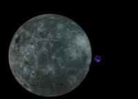
|
Sep 8 2015, 01:38 PM
Post
#5
|
|
|
Newbie Group: Members Posts: 16 Joined: 25-January 14 Member No.: 7109 |
Today there's an official confirmation from Xinhua (the state media) that CE4 will be land on the farside: http://news.xinhuanet.com/tech/2015-09/08/c_1116498505.htm (in Chinese).
|
|
|
|
|
Sep 9 2015, 01:46 PM
Post
#6
|
|
|
Member Group: Members Posts: 149 Joined: 18-June 08 Member No.: 4216 |
QUOTE (Yeh @ Sep 8 2015, 02:38 PM)  Today there's an official confirmation from Xinhua (the state media) that CE4 will be land on the farside: http://news.xinhuanet.com/tech/2015-09/08/c_1116498505.htm (in Chinese). In that case, they will need a relay satellite, either in lunar orbit or further afield eg Earth-Moon L2 |
|
|
|
|
Sep 9 2015, 01:54 PM
Post
#7
|
|
|
Solar System Cartographer Group: Members Posts: 10164 Joined: 5-April 05 From: Canada Member No.: 227 |
-------------------- ... because the Solar System ain't gonna map itself.
Also to be found posting similar content on https://mastodon.social/@PhilStooke Maps for download (free PD: https://upload.wikimedia.org/wikipedia/comm...Cartography.pdf NOTE: everything created by me which I post on UMSF is considered to be in the public domain (NOT CC, public domain) |
|
|
|
|
Jan 6 2016, 12:55 PM
Post
#8
|
|
|
Member Group: Members Posts: 239 Joined: 28-October 12 Member No.: 6732 |
QUOTE (A.Nemo @ Jul 15 2015, 02:43 PM) there is a puzzle news: ... This refers probably to the micro-reflector array INRRI (Instrument for landing-Roving laser Retroreflectors Investigations). INRRI has been sized to give the right signal for LOLA (Lunar Orbiter Laser Altimeter) on LRO. By the way, one INRRI was mounted on EDM Schiaparelli as long-time scientific asset. |
|
|
|
|
Jan 14 2016, 01:39 PM
Post
#9
|
|
 Member Group: Members Posts: 123 Joined: 3-September 12 From: Almeria, SE Spain Member No.: 6632 |
It seems that Cháng'é 4 will go to the lunar farside end of 2018!
QUOTE SinoDefence @SinoDefence Chang'e 4 mission given goahead. Relay sat in Jun 18, followed by landing on Moon far side in late 2018. https://twitter.com/SinoDefence/status/687618528933998592 http://www.chinadaily.com.cn/micro-reading...t_14484287.html Thorsten |
|
|
|
|
Apr 14 2016, 06:01 PM
Post
#10
|
|
|
Member Group: Members Posts: 239 Joined: 28-October 12 Member No.: 6732 |
German "Lunar Lander Neutron Dosimetry" (LND) experiment is going to the lunar far side.
|
|
|
|
|
Apr 15 2016, 08:19 AM
Post
#11
|
||
|
Junior Member Group: Members Posts: 31 Joined: 10-January 14 Member No.: 7094 |
China Follow-on Luna Exploration Projects:
2018,Chang'e-4 to farside of Moon 2023,Chang'e-6(?) ,sample&return from farside of Moon 2025,Chang'e-?, south pole landing & large area cruise 2027,Chang'e-?, north pole landing & ISRU Experimental
Attached thumbnail(s)
|
|
|
|
|
|
|
May 17 2016, 06:45 AM
Post
#12
|
|
|
Member Group: Members Posts: 239 Joined: 28-October 12 Member No.: 6732 |
A joint Dutch and Chinese low frequency receiver installed on the relay satellite and the Swedish Advanced Small Analyzer for Neutrals (ASAN) instrument for the rover are two other European contributions to the Chang'e-4 expedition.
|
|
|
|
|
Jun 3 2016, 02:58 PM
Post
#13
|
|
|
Solar System Cartographer Group: Members Posts: 10164 Joined: 5-April 05 From: Canada Member No.: 227 |
http://www.chinaspaceflight.com/satellite/.../CE-4/CE-4.html
Chang E IV: June 2018 Long March rocket four C relay communications satellite in late 2018 Long March III B rocket lander and inspection devices. This item includes an image of the general landing area in the Apollo basin. Long Xiao had suggested to me at LPSC that this would be the (or a) target http://www.chinaspaceflight.com/usr/upload...41417135287.jpg Phil -------------------- ... because the Solar System ain't gonna map itself.
Also to be found posting similar content on https://mastodon.social/@PhilStooke Maps for download (free PD: https://upload.wikimedia.org/wikipedia/comm...Cartography.pdf NOTE: everything created by me which I post on UMSF is considered to be in the public domain (NOT CC, public domain) |
|
|
|
|
Jun 20 2016, 11:14 AM
Post
#14
|
|
|
Solar System Cartographer Group: Members Posts: 10164 Joined: 5-April 05 From: Canada Member No.: 227 |
A fascinating new paper is now online - Wang and Liu (2016), A Change-4 mission concept and vision of future Chinese lunar exploration activities, Acta Astronautica (available online 11 JUne 2016). If you have access!
It suggests that Apollo basin is the most likely target but other farside basins are possible. Also looks ahead to future missions, including a suggestion that a robotic station could be built up, possibly as a precursor to human flights. From 3 to 5 landers near the south pole, carrying between them up to a dozen rovers, to build the station, which has obvious echoes of ESA's robotic lunar village. Phil -------------------- ... because the Solar System ain't gonna map itself.
Also to be found posting similar content on https://mastodon.social/@PhilStooke Maps for download (free PD: https://upload.wikimedia.org/wikipedia/comm...Cartography.pdf NOTE: everything created by me which I post on UMSF is considered to be in the public domain (NOT CC, public domain) |
|
|
|
|
Oct 2 2016, 05:11 PM
Post
#15
|
|
|
Senior Member Group: Members Posts: 2086 Joined: 13-February 10 From: Ontario Member No.: 5221 |
http://spaceflightnow.com/2016/09/29/china...de-of-the-moon/
Near side sample return might be launched next year, while the far side relay could be used by other space agencies for their own missions. It would certainly save good money! |
|
|
|
|
Jun 6 2017, 04:15 PM
Post
#16
|
|
|
Solar System Cartographer Group: Members Posts: 10164 Joined: 5-April 05 From: Canada Member No.: 227 |
Chang'E 4 landing site:
https://www.chinaspaceflight.com/satellite/.../CE-4/CE-4.html Landing area - 45.5 degrees south latitude, 178 degrees east longitude This is on the flat floor of the large crater Von Karman, with a bit of ejecta from the relatively young crater Finsen. Until now most indications had been for a landing near the Apollo basin at about 42 south, 157 west (203 east). Phil -------------------- ... because the Solar System ain't gonna map itself.
Also to be found posting similar content on https://mastodon.social/@PhilStooke Maps for download (free PD: https://upload.wikimedia.org/wikipedia/comm...Cartography.pdf NOTE: everything created by me which I post on UMSF is considered to be in the public domain (NOT CC, public domain) |
|
|
|
|
Jun 11 2017, 08:24 PM
Post
#17
|
||
|
Solar System Cartographer Group: Members Posts: 10164 Joined: 5-April 05 From: Canada Member No.: 227 |
Here's a couple of maps showing the CE4 area.
Phil
-------------------- ... because the Solar System ain't gonna map itself.
Also to be found posting similar content on https://mastodon.social/@PhilStooke Maps for download (free PD: https://upload.wikimedia.org/wikipedia/comm...Cartography.pdf NOTE: everything created by me which I post on UMSF is considered to be in the public domain (NOT CC, public domain) |
|
|
|
|
|
|
Jun 12 2017, 04:37 AM
Post
#18
|
|
|
Member Group: Members Posts: 315 Joined: 1-October 06 Member No.: 1206 |
Phil
I take it Von Karman's walls are sufficiently lofty to be visible in any surface imagery taken from inside that box? p |
|
|
|
|
Jun 12 2017, 05:35 AM
Post
#19
|
|
|
Senior Member Group: Members Posts: 2086 Joined: 13-February 10 From: Ontario Member No.: 5221 |
I wouldn't be so sure; the horizon is really close in the Chang'E 3 surface images. We shouldn't expect huge vistas anymore than we get them on Mars; cool terrain is by definition hazardous!
I would welcome being pleasant surprised to see anything more than a few km away, of course. |
|
|
|
|
Jun 12 2017, 05:16 PM
Post
#20
|
|
|
Solar System Cartographer Group: Members Posts: 10164 Joined: 5-April 05 From: Canada Member No.: 227 |
Short answer - I think some relief will be visible. Von Karman is about 3500 m deep and some distant topography should show up.
I will post something on the Chang'E 3 thread about distant topography. There are distant hills to the north and west at distances of 10 to 15 km, protruding above closer topography. To the east the horizon is about 4 km from the lander. Phil EDIT: OK, I posted in the other thread. That was a very flat site, but local high spots can be seen about 10 km away. I would expect that either the central peak of Von Karman or the SE wall of the crater should be visible from the lander, and possibly both will be, as well as small crater rims closer to the landing site. Not high mountains like Taurus-Littrow, but distant features should be visible, appearing as low hills. -------------------- ... because the Solar System ain't gonna map itself.
Also to be found posting similar content on https://mastodon.social/@PhilStooke Maps for download (free PD: https://upload.wikimedia.org/wikipedia/comm...Cartography.pdf NOTE: everything created by me which I post on UMSF is considered to be in the public domain (NOT CC, public domain) |
|
|
|
|
Jul 6 2017, 06:01 PM
Post
#21
|
|
|
Solar System Cartographer Group: Members Posts: 10164 Joined: 5-April 05 From: Canada Member No.: 227 |
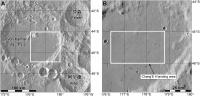
More information on site selection for CE4. This image:
https://www.chinaspaceflight.com/usr/upload...53834140857.jpg from this site: https://www.chinaspaceflight.com/satellite/.../CE-4/CE-4.html shows a number of sites at about 45 degrees north or south. I am preparing something on this topic, so I will post a map later. Some sites are in mare-type areas of the SPA basin or the large craters in that area, but the northern sites are all in or between large craters in the highlands (Mare Moscoviense is not one of these areas). This is from a presentation at the German Aerospace Centre DLR, where China and Germany have just agreed to cooperate on the mission, Germany joining several other countries. Phil -------------------- ... because the Solar System ain't gonna map itself.
Also to be found posting similar content on https://mastodon.social/@PhilStooke Maps for download (free PD: https://upload.wikimedia.org/wikipedia/comm...Cartography.pdf NOTE: everything created by me which I post on UMSF is considered to be in the public domain (NOT CC, public domain) |
|
|
|
|
Jul 7 2017, 12:22 AM
Post
#22
|
||
|
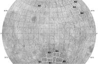
Solar System Cartographer Group: Members Posts: 10164 Joined: 5-April 05 From: Canada Member No.: 227 |
Here is a map of those sites from the slide linked to above.
Phil
-------------------- ... because the Solar System ain't gonna map itself.
Also to be found posting similar content on https://mastodon.social/@PhilStooke Maps for download (free PD: https://upload.wikimedia.org/wikipedia/comm...Cartography.pdf NOTE: everything created by me which I post on UMSF is considered to be in the public domain (NOT CC, public domain) |
|
|
|
|
|
|
Jul 7 2017, 01:32 AM
Post
#23
|
|
 Senior Member Group: Members Posts: 2530 Joined: 20-April 05 Member No.: 321 |
Probably everyone knows this, but on the Moon, the horizon is inherently closer than from a similar vantage point on Earth or Mars. Though the bowl of a crater may make the global curvature locally moot.
|
|
|
|
|
Jul 7 2017, 06:00 PM
Post
#24
|
|
|
Solar System Cartographer Group: Members Posts: 10164 Joined: 5-April 05 From: Canada Member No.: 227 |
That's true, of course, but the distance to the ideal horizon is not as important as the height and distance of significant relief features. Von Karman is about 160 km across and up to 4 km deep (wall height varies quite a bit). A good comparison might be with Flamsteed P, the flooded crater which Surveyor 1 landed in. It is 80 km across, but mostly filled with lava and with hills 1500 m high protruding above the plains. Hills 20 km away were visible in the Surveyor 1 panorama. Scaling up, I am confident there will be some relief on the CE4 horizon. Maybe if the landing is in exactly the worst place for viewing relief there would not be much, but from many areas some features will be visible.
Phil -------------------- ... because the Solar System ain't gonna map itself.
Also to be found posting similar content on https://mastodon.social/@PhilStooke Maps for download (free PD: https://upload.wikimedia.org/wikipedia/comm...Cartography.pdf NOTE: everything created by me which I post on UMSF is considered to be in the public domain (NOT CC, public domain) |
|
|
|
|
Feb 27 2018, 07:49 PM
Post
#25
|
|
|
Solar System Cartographer Group: Members Posts: 10164 Joined: 5-April 05 From: Canada Member No.: 227 |
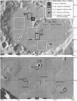
The Von Karman site may not be the final word on site selection... it was identified in a paper in 2017, but two papers by Jia et al. in 2018 (one in the Chinese Journal for Deep Space Exploration, the other in Planetary and Space Science, essentially the same content) prefer the site numbered S5 in the map a few posts above. It is south of the Apollo basin and closer to the centre of the SPA basin than any other of those mapped sites. I think all we have right now is competing suggestions, and the final target may still be uncertain.
Phil -------------------- ... because the Solar System ain't gonna map itself.
Also to be found posting similar content on https://mastodon.social/@PhilStooke Maps for download (free PD: https://upload.wikimedia.org/wikipedia/comm...Cartography.pdf NOTE: everything created by me which I post on UMSF is considered to be in the public domain (NOT CC, public domain) |
|
|
|
|
Mar 18 2018, 06:09 PM
Post
#26
|
|
|
Solar System Cartographer Group: Members Posts: 10164 Joined: 5-April 05 From: Canada Member No.: 227 |
I'm at the Microsymposium just prior to LPSC. It just concluded, with presentations on the Chang'E program and others. Specifically for this thread, Von Karman seemed to be the likely site again - Apollo was promoted as a good site but probably for a future mission.
Phil -------------------- ... because the Solar System ain't gonna map itself.
Also to be found posting similar content on https://mastodon.social/@PhilStooke Maps for download (free PD: https://upload.wikimedia.org/wikipedia/comm...Cartography.pdf NOTE: everything created by me which I post on UMSF is considered to be in the public domain (NOT CC, public domain) |
|
|
|
|
Apr 11 2018, 05:10 PM
Post
#27
|
|
|
Solar System Cartographer Group: Members Posts: 10164 Joined: 5-April 05 From: Canada Member No.: 227 |
Suggest a name for the CE4 relay satellite:
http://www.nssc.cas.cn/tzgg2015/tzgg_tzgg/...29_4987980.html (Google translation) Concerning the notification of the recruitment of the No. 4 relay star name Article Source: Release Time:2018-03-29 All relevant units: The fourth relay satellite will be launched in May 2018. Considering that the No. 4 mission will be the biggest bright spot in China's aerospace field in 2018, to further establish a good image of the lunar exploration project and expand the influence of the project, the Lunar Exploration and Space Engineering Center plans to use the project implementation unit as the main target for solicitation of No. 4 Relay star name. The No. 4 relay star name collection activity will take place from March 27 to April 15, 2018. The names so collected should reflect the theme of lunar exploration, have innovative and significant technological and cultural characteristics, be positive, and conform to the socialist core values. Specially invited your organization to participate in this solicitation. Please refer to the attachment for specific requirements. Attachment: Program for Selection of Relay No. 4 Relay Stars Moon Exploration and Aerospace Engineering Center March 27, 2018 -------------------- ... because the Solar System ain't gonna map itself.
Also to be found posting similar content on https://mastodon.social/@PhilStooke Maps for download (free PD: https://upload.wikimedia.org/wikipedia/comm...Cartography.pdf NOTE: everything created by me which I post on UMSF is considered to be in the public domain (NOT CC, public domain) |
|
|
|
|
Apr 22 2018, 06:20 PM
Post
#28
|
|
|
Solar System Cartographer Group: Members Posts: 10164 Joined: 5-April 05 From: Canada Member No.: 227 |
This link is to the current issue of China's Journal of Deep Space Exploration:
http://jdse.bit.edu.cn/sktcxben/ch/reader/issue_list.aspx A very interesting set of papers about the CE4 landing site including several suggestions for landing sites and even rover traverse routes. Chinese language with English abstract, but Google document translation will help, and the illustrations carry a lot of information even without translation. Many of these papers will probably appear in English elsewhere at a later date. I can feel a map coming on... Phil -------------------- ... because the Solar System ain't gonna map itself.
Also to be found posting similar content on https://mastodon.social/@PhilStooke Maps for download (free PD: https://upload.wikimedia.org/wikipedia/comm...Cartography.pdf NOTE: everything created by me which I post on UMSF is considered to be in the public domain (NOT CC, public domain) |
|
|
|
|
Apr 23 2018, 11:48 PM
Post
#29
|
||
|
Solar System Cartographer Group: Members Posts: 10164 Joined: 5-April 05 From: Canada Member No.: 227 |
After a suitable gestation period, here is a map of the sites suggested for Chang'E 4 in Von Karman crater. The references are from the previous post except the mention of Snape et al. (2010) which is an LPSC abstract, easy to search for if you need it. THe bottom map includes possible traverses suggested by Mou et al. (2018)
Phil
-------------------- ... because the Solar System ain't gonna map itself.
Also to be found posting similar content on https://mastodon.social/@PhilStooke Maps for download (free PD: https://upload.wikimedia.org/wikipedia/comm...Cartography.pdf NOTE: everything created by me which I post on UMSF is considered to be in the public domain (NOT CC, public domain) |
|
|
|
|
|
|
Apr 24 2018, 02:38 AM
Post
#30
|
|
|
Solar System Cartographer Group: Members Posts: 10164 Joined: 5-April 05 From: Canada Member No.: 227 |
http://news.cnstock.com/news,bwkx-201804-4214240.htm
Google translate: China Securities News reported on April 24 from the National Bureau of Science, Technology, and Technology that during the opening ceremony of the "China Aerospace Day" home event in 2018, Wu Yanhua said that the Chang'e 4 is one of the major tasks for China's space industry this year... Wu Yanhua announced at the opening ceremony that the No. 4 relay star was named "Bianqiao" and the two small satellites were named "Longjiang No. 1" and "Longjiang No. 2". Phil -------------------- ... because the Solar System ain't gonna map itself.
Also to be found posting similar content on https://mastodon.social/@PhilStooke Maps for download (free PD: https://upload.wikimedia.org/wikipedia/comm...Cartography.pdf NOTE: everything created by me which I post on UMSF is considered to be in the public domain (NOT CC, public domain) |
|
|
|
|
Apr 24 2018, 09:39 PM
Post
#31
|
|
|
Solar System Cartographer Group: Members Posts: 10164 Joined: 5-April 05 From: Canada Member No.: 227 |
Interesting that Google translates that website to give the relay satellite name 'Bianqiao', but all other sources - AND using Google to translate just the characters for that name, give 'Queqiao'. The names mean Magpie Bridge (relay) and Dragon River (the two small satellites), and there are numerous tweets and stories out there today giving the background.
Late in the year we will presumably get a name for the new rover. Phil -------------------- ... because the Solar System ain't gonna map itself.
Also to be found posting similar content on https://mastodon.social/@PhilStooke Maps for download (free PD: https://upload.wikimedia.org/wikipedia/comm...Cartography.pdf NOTE: everything created by me which I post on UMSF is considered to be in the public domain (NOT CC, public domain) |
|
|
|
|
May 20 2018, 10:08 PM
Post
#32
|
|
|
Solar System Cartographer Group: Members Posts: 10164 Joined: 5-April 05 From: Canada Member No.: 227 |
The relay satellite was just launched successfully.
Phil -------------------- ... because the Solar System ain't gonna map itself.
Also to be found posting similar content on https://mastodon.social/@PhilStooke Maps for download (free PD: https://upload.wikimedia.org/wikipedia/comm...Cartography.pdf NOTE: everything created by me which I post on UMSF is considered to be in the public domain (NOT CC, public domain) |
|
|
|
|
May 20 2018, 10:23 PM
Post
#33
|
|
|
Merciless Robot Group: Admin Posts: 8784 Joined: 8-December 05 From: Los Angeles Member No.: 602 |
Ah, thanks, Phil! Was wondering; didn't seem to be a live feed available anywhere.
-------------------- A few will take this knowledge and use this power of a dream realized as a force for change, an impetus for further discovery to make less ancient dreams real.
|
|
|
|
|
May 20 2018, 10:29 PM
Post
#34
|
|
|
Senior Member Group: Members Posts: 2086 Joined: 13-February 10 From: Ontario Member No.: 5221 |
Someone at the site pointed their phone at a screen, and streamed it out via a Chinese media platform; looks like the micro-satellites also separated successfully.
|
|
|
|
|
May 21 2018, 09:30 AM
Post
#35
|
|
|
Member Group: Members Posts: 156 Joined: 22-May 09 From: Ireland Member No.: 4792 |
|
|
|
|
|
May 25 2018, 10:40 PM
Post
#36
|
|
|
Solar System Cartographer Group: Members Posts: 10164 Joined: 5-April 05 From: Canada Member No.: 227 |
It seems all is well with our new mission - the relay satellite has passed the Moon and is on its way to its L2 halo orbit. The two little moon orbiters are in lunar orbit. Hoping for an image or two from the Saudi camera on one of them.
Phil -------------------- ... because the Solar System ain't gonna map itself.
Also to be found posting similar content on https://mastodon.social/@PhilStooke Maps for download (free PD: https://upload.wikimedia.org/wikipedia/comm...Cartography.pdf NOTE: everything created by me which I post on UMSF is considered to be in the public domain (NOT CC, public domain) |
|
|
|
|
May 27 2018, 09:56 PM
Post
#37
|
|
|
Solar System Cartographer Group: Members Posts: 10164 Joined: 5-April 05 From: Canada Member No.: 227 |
Twitter: Jonathan McDowell @planet4589 2 hours ago
So it looks like Longjiang-2 (DSLWP-  is in a 350 x 13800 km x 21 deg lunar orbit. Longjiang-1 seems to have failed on May 21 and presumably remains in distant Earth orbit following its lunar flyby is in a 350 x 13800 km x 21 deg lunar orbit. Longjiang-1 seems to have failed on May 21 and presumably remains in distant Earth orbit following its lunar flyby------------------ I spoke prematurely in my last post - all seems well with the other two spacecraft but Longjiang 1 failed. The small camera is on Longjiang 2. I see some reports that radio enthusiasts will be able to download images from the camera, but I don't know the details yet. Phil -------------------- ... because the Solar System ain't gonna map itself.
Also to be found posting similar content on https://mastodon.social/@PhilStooke Maps for download (free PD: https://upload.wikimedia.org/wikipedia/comm...Cartography.pdf NOTE: everything created by me which I post on UMSF is considered to be in the public domain (NOT CC, public domain) |
|
|
|
| Guest_mcmcmc_* |
Jun 13 2018, 07:30 AM
Post
#38
|
|
Guests |
"Are we there yet?"

|
|
|
|
|
Jun 14 2018, 04:16 PM
Post
#39
|
|
|
Solar System Cartographer Group: Members Posts: 10164 Joined: 5-April 05 From: Canada Member No.: 227 |
-------------------- ... because the Solar System ain't gonna map itself.
Also to be found posting similar content on https://mastodon.social/@PhilStooke Maps for download (free PD: https://upload.wikimedia.org/wikipedia/comm...Cartography.pdf NOTE: everything created by me which I post on UMSF is considered to be in the public domain (NOT CC, public domain) |
|
|
|
| Guest_mcmcmc_* |
Jun 14 2018, 05:49 PM
Post
#40
|
|
Guests |
QUOTE (Phil Stooke @ Jun 14 2018, 05:16 PM) Cool! 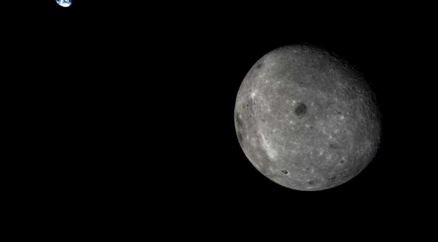
|
|
|
|
| Guest_mcmcmc_* |
Jun 14 2018, 06:53 PM
Post
#41
|
|
Guests |
Hayabusa twitter aggregator
http://win98.altervista.org/hayabusa2/TwitterAggregator.html |
|
|
|
|
Jun 14 2018, 07:00 PM
Post
#42
|
|
|
Member Group: Members Posts: 123 Joined: 3-September 12 From: Almeria, SE Spain Member No.: 6632 |
Nice pic, but it's not new.
It's from Chang'e-5 T1, from october 2014. This one is new, from the Longjiang-2 micro satellite. The camera has captured its place of origin, Saudi Arabia.  Thorsten 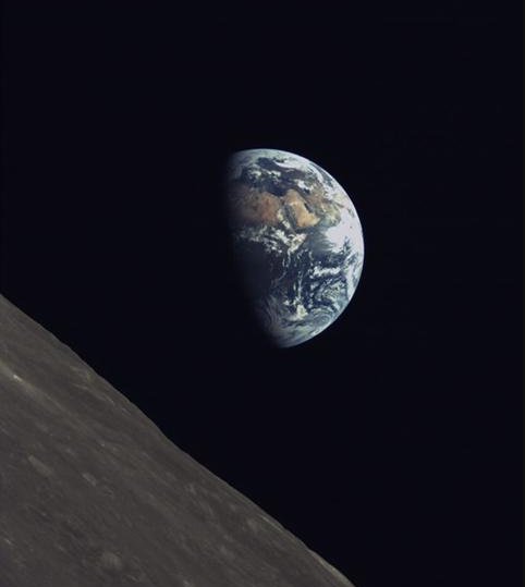 |
|
|
|
|
Jun 14 2018, 07:13 PM
Post
#43
|
|
|
Member Group: Members Posts: 156 Joined: 22-May 09 From: Ireland Member No.: 4792 |
|
|
|
|
| Guest_mcmcmc_* |
Jun 15 2018, 06:51 AM
Post
#44
|
|
Guests |
Better images from Saudi Arabia camera onboard Longjiang-2 satellite, the only survivor of the two small satellites launched together with Queqiao:
  http://www.planetary.org/blogs/jason-davis...earth-pics.html |
|
|
|
|
Aug 6 2018, 10:48 AM
Post
#45
|
||
|
Solar System Cartographer Group: Members Posts: 10164 Joined: 5-April 05 From: Canada Member No.: 227 |
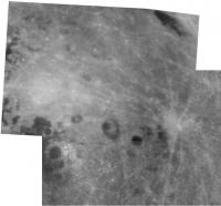
Andrew Jones (https://twitter.com/AJ_FI) reports some new images from the Saudi camera. EDIT - Andrew has just pointed out to me that the image is not from the Saudi camera, but from a second camera which I was not aware of or had forgotten about. This was developed by students in China.
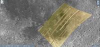
One, which I assume is a mosaic of many image strips, covers Mare Nubium. This shows the image coverage on a background from LRO Quickmap. Phil
-------------------- ... because the Solar System ain't gonna map itself.
Also to be found posting similar content on https://mastodon.social/@PhilStooke Maps for download (free PD: https://upload.wikimedia.org/wikipedia/comm...Cartography.pdf NOTE: everything created by me which I post on UMSF is considered to be in the public domain (NOT CC, public domain) |
|
|
|
|
|
|
Aug 6 2018, 04:10 PM
Post
#46
|
|
|
Founder Group: Chairman Posts: 14432 Joined: 8-February 04 Member No.: 1 |
I think those are just symptoms of SSTV ham radio downlink.
|
|
|
|
|
Aug 6 2018, 09:59 PM
Post
#47
|
|
|
Solar System Cartographer Group: Members Posts: 10164 Joined: 5-April 05 From: Canada Member No.: 227 |
Yes, looking at it now I'm inclined to agree.
Phil -------------------- ... because the Solar System ain't gonna map itself.
Also to be found posting similar content on https://mastodon.social/@PhilStooke Maps for download (free PD: https://upload.wikimedia.org/wikipedia/comm...Cartography.pdf NOTE: everything created by me which I post on UMSF is considered to be in the public domain (NOT CC, public domain) |
|
|
|
|
Sep 19 2018, 06:47 PM
Post
#48
|
|
|
Solar System Cartographer Group: Members Posts: 10164 Joined: 5-April 05 From: Canada Member No.: 227 |
http://www.spaceflightfans.cn/39192.html#more-39192
Summarizing from the above link, using Google translation: The Chang'e 4 rover will have a name soon. A competition was held starting on 15 August, and on 18 September a shortlist of the many submitted names was announced after a meeting in Beijing. The shortlisted names are: dream-by-dream Guangming [= bright or brightness] Yutu No.2 exploration journey elf fearless Wangshu (one of the former kingdoms of China 1000 years ago) walker golden rabbit (the first one looks like a bad translation) The final name will be picked in October. Phil -------------------- ... because the Solar System ain't gonna map itself.
Also to be found posting similar content on https://mastodon.social/@PhilStooke Maps for download (free PD: https://upload.wikimedia.org/wikipedia/comm...Cartography.pdf NOTE: everything created by me which I post on UMSF is considered to be in the public domain (NOT CC, public domain) |
|
|
|
|
Sep 19 2018, 06:55 PM
Post
#49
|
|
|
Senior Member Group: Members Posts: 2086 Joined: 13-February 10 From: Ontario Member No.: 5221 |
Golden rabbit sounds really fun! It has my vote (for what it's worth...)
|
|
|
|
|
Sep 19 2018, 11:56 PM
Post
#50
|
||
|
Solar System Cartographer Group: Members Posts: 10164 Joined: 5-April 05 From: Canada Member No.: 227 |
Phil -------------------- ... because the Solar System ain't gonna map itself.
Also to be found posting similar content on https://mastodon.social/@PhilStooke Maps for download (free PD: https://upload.wikimedia.org/wikipedia/comm...Cartography.pdf NOTE: everything created by me which I post on UMSF is considered to be in the public domain (NOT CC, public domain) |
|
|
|
|
|
|
Sep 20 2018, 02:34 PM
Post
#51
|
|
 Junior Member Group: Members Posts: 28 Joined: 17-April 08 From: Okemos, MI, USA Member No.: 4097 |
My Chinese is just ok, but I would translate them like so:
逐梦 = Dream Chaser 光明 = Bright (literally, but also as in a bright future) 玉兔二号 = Jade Rabbit #2 探索 = Explorer 征途 = Trek (like a long voyage, but not the same word as in Star Trek, oddly) 精灵 = Genius 无畏 = Fearless 望舒 = To Spread Across the Moon / To Spread Our Hopes (this one is sort of a subtle pun that's hard to translate) 行者 = Walker (as in the sense of walking the Earth like an ancient monk) 金兔 = Gold Rabbit |
|
|
|
|
Sep 20 2018, 05:35 PM
Post
#52
|
|
|
Solar System Cartographer Group: Members Posts: 10164 Joined: 5-April 05 From: Canada Member No.: 227 |
Thanks!
And now Andrew Jones has these meanings: 逐梦 - Zhu Meng (chasing the dream, dream catching) 光明 - Brightness 玉兔二号 - Yutu II (Jade Rabbit 2) 探索 - Exploration 征途 - Expedition 精灵 - Genius (Fairy or elf) 无畏 - Fearless 望舒 - Wang Shu (a god that drives for the Moon in Chinese mythology; also can be used to refer to the Moon) 行者 - Stroller or Hiker 金兔 - Golden Rabbit https://gbtimes.com/change-4-shortlist-of-1...s-space-program EDIT: I would interpret 'genius' like the latin 'genius loci', or spirit of a place, associated with a place, rather than the modern English meaning of Genius. Phil -------------------- ... because the Solar System ain't gonna map itself.
Also to be found posting similar content on https://mastodon.social/@PhilStooke Maps for download (free PD: https://upload.wikimedia.org/wikipedia/comm...Cartography.pdf NOTE: everything created by me which I post on UMSF is considered to be in the public domain (NOT CC, public domain) |
|
|
|
|
Nov 9 2018, 10:30 PM
Post
#53
|
||
|
Solar System Cartographer Group: Members Posts: 10164 Joined: 5-April 05 From: Canada Member No.: 227 |
http://lilacsat.hit.edu.cn/dashboard/pages_en/pics-b.html
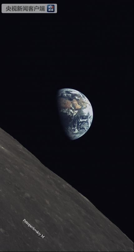
This website posts pictures from the little student camera (from the Harbin Institute of Technology) on Longjiang 2 (also know as DSLWP- , which can be commanded by radio amateurs on Earth. One of the most recent is this one:
- showing the farside and Earth. The green channel is severely underexposed so this is processed to remove a purplish tint and to brighten the image. Phil -------------------- ... because the Solar System ain't gonna map itself.
Also to be found posting similar content on https://mastodon.social/@PhilStooke Maps for download (free PD: https://upload.wikimedia.org/wikipedia/comm...Cartography.pdf NOTE: everything created by me which I post on UMSF is considered to be in the public domain (NOT CC, public domain) |
|
|
|
|
|
| Guest_mcmcmc_* |
Nov 9 2018, 11:19 PM
Post
#54
|
|
Guests |
QUOTE (Phil Stooke @ Nov 9 2018, 11:30 PM) http://lilacsat.hit.edu.cn/dashboard/pages_en/pics-b.html This website posts pictures from the little student camera Really cool. It's a pity they don't release any timestamp, which would allow an amazing animation! |
|
|
|
|
Nov 10 2018, 06:00 AM
Post
#55
|
||
|
Solar System Cartographer Group: Members Posts: 10164 Joined: 5-April 05 From: Canada Member No.: 227 |
Here's another with a few missing lines.
The time data may be available. I will look for it. Phil
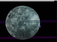
EDIT: more data here: https://charon.camras.nl/public/dslwp-b/ See also this very useful blog: https://destevez.net/ -------------------- ... because the Solar System ain't gonna map itself.
Also to be found posting similar content on https://mastodon.social/@PhilStooke Maps for download (free PD: https://upload.wikimedia.org/wikipedia/comm...Cartography.pdf NOTE: everything created by me which I post on UMSF is considered to be in the public domain (NOT CC, public domain) |
|
|
|
|
|
| Guest_mcmcmc_* |
Nov 10 2018, 10:50 AM
Post
#56
|
|
Guests |
I wonder what this sat will see while Chang'e4 is incoming.
|
|
|
|
|
Nov 18 2018, 08:34 PM
Post
#57
|
|
|
Solar System Cartographer Group: Members Posts: 10164 Joined: 5-April 05 From: Canada Member No.: 227 |
Check out this excellent blog by Daniel Estevez:
https://destevez.net/2018/11/november-dslwp...moon-and-earth/ - and if you go right to the end you will find an animation exactly like that mentioned above by mcmcmc. Phil -------------------- ... because the Solar System ain't gonna map itself.
Also to be found posting similar content on https://mastodon.social/@PhilStooke Maps for download (free PD: https://upload.wikimedia.org/wikipedia/comm...Cartography.pdf NOTE: everything created by me which I post on UMSF is considered to be in the public domain (NOT CC, public domain) |
|
|
|
|
Nov 18 2018, 08:45 PM
Post
#58
|
||
|
Solar System Cartographer Group: Members Posts: 10164 Joined: 5-April 05 From: Canada Member No.: 227 |
And a mosaic of two recent images (Mare Humboldtianum* in the top right corner)
Phil
EDIT: * corrected 'Moscoviense' to 'Humboldtianum' above - how could I have made that silly mistake? -------------------- ... because the Solar System ain't gonna map itself.
Also to be found posting similar content on https://mastodon.social/@PhilStooke Maps for download (free PD: https://upload.wikimedia.org/wikipedia/comm...Cartography.pdf NOTE: everything created by me which I post on UMSF is considered to be in the public domain (NOT CC, public domain) |
|
|
|
|
|
|
Dec 6 2018, 07:04 PM
Post
#59
|
|
|
Solar System Cartographer Group: Members Posts: 10164 Joined: 5-April 05 From: Canada Member No.: 227 |
Chang'e 4 launch set for tomorrow. We still don't have the rover name yet.
Phil -------------------- ... because the Solar System ain't gonna map itself.
Also to be found posting similar content on https://mastodon.social/@PhilStooke Maps for download (free PD: https://upload.wikimedia.org/wikipedia/comm...Cartography.pdf NOTE: everything created by me which I post on UMSF is considered to be in the public domain (NOT CC, public domain) |
|
|
|
|
Dec 7 2018, 05:08 PM
Post
#60
|
|
 Member Group: Members Posts: 905 Joined: 15-June 09 From: Lisbon, Portugal Member No.: 4824 |
It seems that the name was to be decided by an on-line vote, similarly to Chang'e-3 rover, and the most popular was 光明 - guangming ("Brightness"). However a committee was supposed to have made a final choice by late October.
See https://gbtimes.com/online-vote-decides-top...ide-of-the-moon The article has other interesting info on the mission and links to many relevant pages. In here it says that live coverage of the launch seems unlikely. Fernando Edit: Liftoff was successful and Andrew Jones has tweeted an unofficial video stream |
|
|
|
|
Dec 7 2018, 07:37 PM
Post
#61
|
|
|
Member Group: Members Posts: 123 Joined: 3-September 12 From: Almeria, SE Spain Member No.: 6632 |
It seems that the Cháng'é-4 launch has been successful!
 https://mp.weixin.qq.com/s/tUuiI9Ng6CJeQBqkFATguA Thorsten |
|
|
|
|
Dec 8 2018, 11:50 AM
Post
#62
|
|
 Member Group: Members Posts: 550 Joined: 1-May 06 From: Scotland (Ecosse, Escocia) Member No.: 759 |
This is fullest info I found , albeit no updates since launch.
Landing accuracy has to be more precise than Chang'e 3. Xinhua news agency on Chang'e 4 |
|
|
|
|
Dec 10 2018, 06:10 PM
Post
#63
|
|
|
Solar System Cartographer Group: Members Posts: 10164 Joined: 5-April 05 From: Canada Member No.: 227 |
https://www.projectpluto.com/pluto/mpecs/18103b.htm
Interesting item on the CE4 upper stage, detected in an asteroid survey, with a comment on its post-lunar flyby orbit. Phil -------------------- ... because the Solar System ain't gonna map itself.
Also to be found posting similar content on https://mastodon.social/@PhilStooke Maps for download (free PD: https://upload.wikimedia.org/wikipedia/comm...Cartography.pdf NOTE: everything created by me which I post on UMSF is considered to be in the public domain (NOT CC, public domain) |
|
|
|
|
Dec 10 2018, 08:00 PM
Post
#64
|
|
|
Member Group: Members Posts: 550 Joined: 1-May 06 From: Scotland (Ecosse, Escocia) Member No.: 759 |
Video showing the preparation of Chang'e-4 and rover, and some explanation of the descent profile compared with Chang'e-3.
Chang'e-5 video |
|
|
|
|
Dec 12 2018, 11:43 AM
Post
#65
|
|
 Senior Member Group: Members Posts: 1431 Joined: 26-July 08 Member No.: 4270 |
Chang'e 4 is now in lunar orbit.
http://www.china.org.cn/china/2018-12/12/c...nt_74268339.htm -------------------- -- Hungry4info (Sirius_Alpha)
|
|
|
|
|
Dec 12 2018, 06:20 PM
Post
#66
|
|
|
Merciless Robot Group: Admin Posts: 8784 Joined: 8-December 05 From: Los Angeles Member No.: 602 |
Good article from The Planetary Society on this milestone and anticipated future events.
-------------------- A few will take this knowledge and use this power of a dream realized as a force for change, an impetus for further discovery to make less ancient dreams real.
|
|
|
|
|
Dec 13 2018, 12:23 PM
Post
#67
|
||
 Member Group: Members Posts: 290 Joined: 29-December 05 From: Ottawa, ON Member No.: 624 |
I'm amazed by the size of their mission control for the spacecraft. I don't think Apollo 11 had half as many.
Attached thumbnail(s)
|
|
|
|
|
|
|
Dec 13 2018, 08:25 PM
Post
#68
|
|
|
Solar System Cartographer Group: Members Posts: 10164 Joined: 5-April 05 From: Canada Member No.: 227 |
A bit of concern here - let's hope all is well.
Phil https://skyriddles.wordpress.com/2018/12/13...-from-the-moon/ -------------------- ... because the Solar System ain't gonna map itself.
Also to be found posting similar content on https://mastodon.social/@PhilStooke Maps for download (free PD: https://upload.wikimedia.org/wikipedia/comm...Cartography.pdf NOTE: everything created by me which I post on UMSF is considered to be in the public domain (NOT CC, public domain) |
|
|
|
|
Dec 14 2018, 12:28 AM
Post
#69
|
|
|
Forum Contributor Group: Members Posts: 1372 Joined: 8-February 04 From: North East Florida, USA. Member No.: 11 |
QUOTE (Steve G @ Dec 13 2018, 12:23 PM) I'm amazed by the size of their mission control for the spacecraft. I don't think Apollo 11 had half as many. Looks like the back two rows are hangers on.... |
|
|
|
|
Dec 14 2018, 03:41 AM
Post
#70
|
|
|
Senior Member Group: Members Posts: 1431 Joined: 26-July 08 Member No.: 4270 |
QUOTE (Phil Stooke @ Dec 13 2018, 03:25 PM) A bit of concern here - let's hope all is well. Apparently the spacecraft is okay? Just not in the orbit we all assumed it would be in. https://skyriddles.wordpress.com/2018/12/14...arks-the-orbit/ -------------------- -- Hungry4info (Sirius_Alpha)
|
|
|
|
|
Dec 18 2018, 06:04 PM
Post
#71
|
|
|
Member Group: Members Posts: 550 Joined: 1-May 06 From: Scotland (Ecosse, Escocia) Member No.: 759 |
According to this news story from Dec 17, the Chang'e-3 lander (which is still active) is being inhibited from "waking up" on Dec 18 so as not to interfere with the upcoming landing of Chang'e-4. So despite the general absence of news, it appears Chang'e-4 is still on track.
Chang'e-3 preps for Chang'e-4 landing |
|
|
|
|
Dec 18 2018, 06:41 PM
Post
#72
|
|
|
Senior Member Group: Members Posts: 2086 Joined: 13-February 10 From: Ontario Member No.: 5221 |
From the amateur radio listener's post, it appears CE-4 remains in constant view of Earth; would need a heavy delta-vee change or longer wait for precession of the orbit to take it over the far side landing sight.
Given CE-3's surprise last minute change of landing location, I'm actually wondering if they've made another announced change on this mission as well... |
|
|
|
|
Dec 18 2018, 09:06 PM
Post
#73
|
|
|
Solar System Cartographer Group: Members Posts: 10164 Joined: 5-April 05 From: Canada Member No.: 227 |
The moon rotates under that orbit plane, the landing site passes through the orbit plane twice a month, and no change in the orbit is needed for the landing site to be in the right place at the appropriate time.
China is not saying much, but assuming the spacecraft is healthy I can't see any cause for concern. Phil * Also there was no sudden change in the CE3 landing site. The landing area was called 'the Sinus Iridum landing area' but it extended well outside of Sinus Iridum. CE3 landed at its eastern end, which makes sense because if you target that and a technical problem causes a delay of a few orbits, you just land further west in the landing area (as the Moon rotates under the orbit plane). If you target the landing in central Sinus Iridum and have to delay, you risk the landing site slipping into mountainous terrain. -------------------- ... because the Solar System ain't gonna map itself.
Also to be found posting similar content on https://mastodon.social/@PhilStooke Maps for download (free PD: https://upload.wikimedia.org/wikipedia/comm...Cartography.pdf NOTE: everything created by me which I post on UMSF is considered to be in the public domain (NOT CC, public domain) |
|
|
|
|
Dec 20 2018, 08:51 PM
Post
#74
|
|
|
Member Group: Members Posts: 200 Joined: 20-November 05 From: Mare Desiderii Member No.: 563 |
gbtimes reports "Chang'e-4 has had several "phone calls" with Queqiao while around the Moon, with a 'good' signal".
https://gbtimes.com/change-4-lander-makes-c...rom-lunar-orbit QUOTE Chang'e-4 is expected to make its landing attempt in the South Pole-Aitken Basin in early January, with the targeted site understood to be the southern floor of the 186-km-diameter Von Kármán crater.
|
|
|
|
|
Dec 20 2018, 09:13 PM
Post
#75
|
|
|
Senior Member Group: Members Posts: 2086 Joined: 13-February 10 From: Ontario Member No.: 5221 |
Thanks for the explanation Phil...I should have thought a bit more about the geometry!
I wonder if they will attempt another video of the landing, if the bandwidth is good enough. The Chang'E 3 footage was amazing! Incidentally, I checked, and there is a slightly longer signal delay through the relay satellite (about 0.4 seconds) than there would be for a near side landing (since signal needs to travel to the Lagrange point past the Moon, the far side surface, and then back again.) |
|
|
|
|
Dec 30 2018, 06:01 PM
Post
#76
|
|
|
Member Group: Members Posts: 123 Joined: 3-September 12 From: Almeria, SE Spain Member No.: 6632 |
Hi all!
Cháng'é-4 is now in the final 15x100km orbit! https://gbtimes.com/change-4-lowers-orbit-r...ide-of-the-moon Very nice video there! I herewith dare to predict the landing time: 02 January, 00:00 UTC (midnight) at 178.1° East. How do I get there? Quite simple calculations with the publicly available data: First looking at the orbital plane: Lunar orbit insertion (LOI) was on 12Dec at 08:39 (all times UTC) in (- assumption! -) a plane exactly perpendicular to the earth vector, this means "face-on" and over the poles. Furthermore: Landing site: Between 176.4° and 178.7° East. (This is from here.) The orbital plane therefore has to rotate between LOI and landing between 271.3° and 273.6°. Or, more precisely, the Moon under it. Since a sidereal lunar rotation lasts 27.3217 days, this corresponds to a time from LOI to landing of 20.590 and 20.764 days. That falls between 01Jan 22:48 and 02Jan 02:59 (as said, UTC). That's a period of just over 4 hours, enough for two passes. And now, when exactly? The insertion into the final orbit of 15x100km was early today (30Dec) at 0:55 UTC. This injection occurs in the aposelene, this means half an orbit from periselene! And the periselene is logically (almost) over the landing site. The orbital period can be calculated (113.68min), so you just have to look when a multiple-plus-zero-point-five of the orbit period falls into the the time frame calculated above. This is the case (UTC) on 01 Jan at 23:58 (37.5rev) and on 02 Jan at 01:51 (38.5rev). With uncertainty in the minute range and a bit of time for the final (slow) approach, it will be midnight UTC on January 2nd. And the backup opportunity at 177.0° East just before 2h UTC. To all this also fits that on that day, the Moon in Beijing rises at 03:45 (Beijing time). The landing would be at 07:58, the backup landing at 09:51, and the moonset at 14:23. Perfect timing for the ground stations. Some (dis-)agreement here?  Best Thorsten |
|
|
|
|
Dec 31 2018, 08:10 AM
Post
#77
|
|
|
Junior Member Group: Members Posts: 23 Joined: 29-November 05 From: france Member No.: 591 |
No disagreement.
This looks brilliant to me. |
|
|
|
|
Dec 31 2018, 09:14 AM
Post
#78
|
|
|
Merciless Robot Group: Admin Posts: 8784 Joined: 8-December 05 From: Los Angeles Member No.: 602 |
Very impressive orbital mechanical detective work, Thorsten!
It will be fascinating to see how this plays out.
-------------------- A few will take this knowledge and use this power of a dream realized as a force for change, an impetus for further discovery to make less ancient dreams real.
|
|
|
|
|
Jan 2 2019, 03:55 PM
Post
#79
|
|
|
Senior Member Group: Members Posts: 1074 Joined: 21-September 07 From: Québec, Canada Member No.: 3908 |
1- Is there an official Chang'e 4 website?
2- Do we know if the landing will be transmitted live? |
|
|
|
|
Jan 2 2019, 04:46 PM
Post
#80
|
|
|
Member Group: Members Posts: 905 Joined: 15-June 09 From: Lisbon, Portugal Member No.: 4824 |
1- Is there an official Chang'e 4 website? I've been combing the web and couldn't find any
2- Do we know if the landing will be transmitted live? All mentions I've seen say it will not Andrew Jones of the gbtimes has been providing coverage of the mission. On that page is this interesting link The Sun is reporting a Jan 3 landing at about 1:00 UTC, which matches with a tweet I've seen (but lost the reference to). EDIT: techradar has a story about "how to watch live online" by visiting the CGTN site. But this site is unavailable to several European countries, including mine. |
|
|
|
|
Jan 2 2019, 06:22 PM
Post
#81
|
|
|
Member Group: Members Posts: 123 Joined: 3-September 12 From: Almeria, SE Spain Member No.: 6632 |
QUOTE (nprev @ Dec 31 2018, 10:14 AM) Very impressive orbital mechanical detective work, Thorsten! It will be fascinating to see how this plays out.Thanks nprev. But apparently something is wrong:  (1) The LOI plane was not perpendicular to Earth (2) The orbital plane did not remain constant (3) They will land somewhere else (not Von-Kármán) (4) They already have landed but didn't tell (5) I did a mistake somewhere Will be interesting to see what was the reason... Thorsten |
|
|
|
|
Jan 2 2019, 09:33 PM
Post
#82
|
||
|
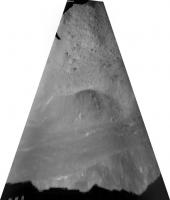
Solar System Cartographer Group: Members Posts: 10164 Joined: 5-April 05 From: Canada Member No.: 227 |
What are we about to see?
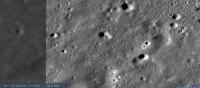
Almost everywhere i look in Von Karman southeast of the central peak the surface is characterized not only by the expected craters but also by a multitude of small troughs or valleys. This scene is about 4 km wide:
Hazard avoidance should allow CE4 to land in a level spot, but traverse planning may be interesting. I will not speculate as to the origin or depth of these features at the moment. Phil EDIT - 7 January - These grooves are further west than the actual landing site. Our area is free of them. -------------------- ... because the Solar System ain't gonna map itself.
Also to be found posting similar content on https://mastodon.social/@PhilStooke Maps for download (free PD: https://upload.wikimedia.org/wikipedia/comm...Cartography.pdf NOTE: everything created by me which I post on UMSF is considered to be in the public domain (NOT CC, public domain) |
|
|
|
|
|
|
Jan 3 2019, 02:46 AM
Post
#83
|
|
|
Senior Member Group: Members Posts: 2086 Joined: 13-February 10 From: Ontario Member No.: 5221 |
Unconfirmed social media reports of a successful landing at 2:26 UTC!
Presumably downloading the landing footage before any official announcement on state media (what I would do to maximize public outreach). |
|
|
|
|
Jan 3 2019, 04:24 AM
Post
#84
|
|
|
Senior Member Group: Members Posts: 1431 Joined: 26-July 08 Member No.: 4270 |
Official Chinese media are reporting successful landing.
-------------------- -- Hungry4info (Sirius_Alpha)
|
|
|
|
|
Jan 3 2019, 04:25 AM
Post
#85
|
|
|
Senior Member Group: Members Posts: 1074 Joined: 21-September 07 From: Québec, Canada Member No.: 3908 |
Landing announced on Xinhuanet link
|
|
|
|
|
Jan 3 2019, 04:59 AM
Post
#86
|
||
|
Senior Member Group: Members Posts: 1431 Joined: 26-July 08 Member No.: 4270 |

Attached thumbnail(s)
-------------------- -- Hungry4info (Sirius_Alpha)
|
|
|
|
|
|
|
Jan 3 2019, 05:07 AM
Post
#87
|
|
|
Merciless Robot Group: Admin Posts: 8784 Joined: 8-December 05 From: Los Angeles Member No.: 602 |
Remarkable. Congratulations to China!
-------------------- A few will take this knowledge and use this power of a dream realized as a force for change, an impetus for further discovery to make less ancient dreams real.
|
|
|
|
|
Jan 3 2019, 05:08 AM
Post
#88
|
|
|
Senior Member Group: Members Posts: 2086 Joined: 13-February 10 From: Ontario Member No.: 5221 |
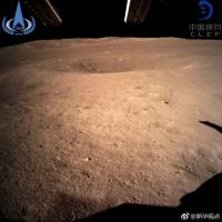
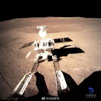
First surface image from the far side. A historic achievement!
Nearby crater and distant hills, should make finding the location easy enough; LRO should pass over the area on January 4th from what I've read. Another image of the landing legs on social media; I can't find the original so I won't link it yet. Video here (skip to 1:11 for apparent real time descent imagery, should make it easy for our resident cartographer to pinpoint the area ) https://krcom.cn/2656274875/episodes/104219...324354331200641 |
|
|
|
|
Jan 3 2019, 06:25 AM
Post
#89
|
||
|
Junior Member Group: Members Posts: 27 Joined: 3-January 05 From: Italy Member No.: 134 |
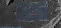
Smartphone screenshot of CCTV 13 news cannel. 14:00 Beijing time edition. Screen in the control room shows the expected landing zone and expected landing point (only one decimal) 177.6 E, 45.5S
|
|
|
|
|
|
|
Jan 3 2019, 08:06 AM
Post
#90
|
|||||
|
Solar System Cartographer Group: Members Posts: 10164 Joined: 5-April 05 From: Canada Member No.: 227 |
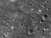
Okey-dokey, here we go.
These are the views from that landing video:
This is an overlay of the landing site image posted just above this, overlain on a Quickmap image of the area:
Zooming in, the area looks like this:
And here two frames from the video are located.
That points to the approximate site. No doubt more tomorrow. Phil -------------------- ... because the Solar System ain't gonna map itself.
Also to be found posting similar content on https://mastodon.social/@PhilStooke Maps for download (free PD: https://upload.wikimedia.org/wikipedia/comm...Cartography.pdf NOTE: everything created by me which I post on UMSF is considered to be in the public domain (NOT CC, public domain) |
||||
|
|
|
||||
|
Jan 3 2019, 08:22 AM
Post
#91
|
||
|
Solar System Cartographer Group: Members Posts: 10164 Joined: 5-April 05 From: Canada Member No.: 227 |
One other comment - the hills on the horizon in the one surface view we have are south of the lander. They are part of the rim of Von Karman, not the central peak. The direction of lighting in the image clearly shows that this must be looking south.
Phil
-------------------- ... because the Solar System ain't gonna map itself.
Also to be found posting similar content on https://mastodon.social/@PhilStooke Maps for download (free PD: https://upload.wikimedia.org/wikipedia/comm...Cartography.pdf NOTE: everything created by me which I post on UMSF is considered to be in the public domain (NOT CC, public domain) |
|
|
|
|
|
|
Jan 3 2019, 08:59 AM
Post
#92
|
|
 Junior Member Group: Members Posts: 98 Joined: 30-November 05 From: Antibes, France Member No.: 594 |
Congratulation to CNSA and the engineers!
Surprised! I don't see a lot of stones in the first view and the surface seems to be particularly soft with a lot of dust. It looks like dry clay (in a windy day), the kind of clay you find in Roland Garros for instance!  |
|
|
|
|
Jan 3 2019, 09:16 AM
Post
#93
|
|
|
Newbie Group: Members Posts: 7 Joined: 22-September 18 From: Bavaria Member No.: 8456 |
QUOTE (Thorsten Denk @ Jan 2 2019, 07:22 PM) (3) They will land somewhere else (not Von-Kármán) What makes you think so? In this videoclip (link provided by Explorer1)at 0:21, from looking at the features that's von Kármán crater (I compared with the Virtual Moon atlas). Thomas |
|
|
|
|
Jan 3 2019, 09:33 AM
Post
#94
|
|
|
Member Group: Members Posts: 123 Joined: 3-September 12 From: Almeria, SE Spain Member No.: 6632 |
QUOTE (Baywa @ Jan 3 2019, 10:16 AM) What makes you think so? In this videoclip (link provided by Explorer1)at 0:21, from looking at the features that's von Kármán crater (I compared with the Virtual Moon atlas). Thomas It's just one out of five points from a list of possible reasons why the calculations in post #76 are not correct. It was written before the actual landing. Now (after the landing) we know that this point is not the reason. In any case, congratulations to the Chinese for the successful landing! Thorsten |
|
|
|
|
Jan 3 2019, 10:25 AM
Post
#95
|
|
|
Newbie Group: Members Posts: 7 Joined: 22-September 18 From: Bavaria Member No.: 8456 |
OK - so I mixed up the OR and the AND operator.
But I would really, really want to figure out what actually happened starting at orbital insertion and ending with the landing approach. For example, maybe they changed the inclination of the orbit?Thomas |
|
|
|
|
Jan 3 2019, 11:03 AM
Post
#96
|
|
|
Senior Member Group: Members Posts: 1074 Joined: 21-September 07 From: Québec, Canada Member No.: 3908 |
Photo of the landing pad on the Moon (link)
|
|
|
|
|
Jan 3 2019, 01:22 PM
Post
#97
|
|
|
Junior Member Group: Members Posts: 27 Joined: 3-January 05 From: Italy Member No.: 134 |
From twitter:
https://twitter.com/Cosmic_Penguin/status/1...6621587456?s=09 "Based on the few descent photos available right now someone in Chinese social media has provided finding charts for #ChangE4. (https://t.co/UiIjI3ngKY) Maybe someone here can get rough landing coordinates of it from the photos below?" Original post on Weibo (Chinese language) https://m.weibo.cn/status/HagktpCG8 |
|
|
|
|
Jan 3 2019, 03:59 PM
Post
#98
|
||
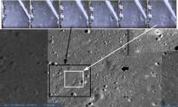
 Member Group: Members Posts: 238 Joined: 15-January 13 Member No.: 6842 |
QUOTE (Phil Stooke @ Jan 3 2019, 08:22 AM) One other comment - the hills on the horizon in the one surface view we have are south of the lander. They are part of the rim of Von Karman, not the central peak. The direction of lighting in the image clearly shows that this must be looking south. Phil
I think the view is towards the largest crater in the immediate vicinity, to the east/south-east of the lander: http://bit.ly/2F5NB9U P.S. QuickMap is strugging to serve so many requests today! -------------------- Curiosity rover panoramas: http://www.facebook.com/CuriosityRoverPanoramas
My Photosynth panoramas: http://photosynth.net/userprofilepage.aspx...;content=Synths |
|
|
|
|
|
|
Jan 3 2019, 04:42 PM
Post
#99
|
|||
|
Senior Member Group: Members Posts: 1431 Joined: 26-July 08 Member No.: 4270 |
Yutu 2 deployment.
Attached thumbnail(s)
-------------------- -- Hungry4info (Sirius_Alpha)
|
||
|
|
|
||
|
Jan 3 2019, 05:13 PM
Post
#100
|
|
|
Member Group: Members Posts: 149 Joined: 18-June 08 Member No.: 4216 |
QUOTE (Hungry4info @ Jan 3 2019, 04:42 PM) Yutu 2 deployment. My..that was quick! A somewhat pedantic comment on Phil's earlier remark about viewing directions (Phil, please correct me if I messed up somewhere). It is true that the direction of lighting implies that the mountain ridge on the horizon must be south of the lander and therefore part of the rim of Von Karman, rather than its central peak, but this inference takes also into account the addiitonal knowledge of time of (lunar) day. If the landing were to have taken place near local sunset, witnessing the same shadow direction right after landing would imply a northwards view. Further on the issue of mountains, I recall from looking at pictures of the Von Karman floor posted earlier with the likely location of Ch4 in it that there is a "positive relief feature" just north of the landing site which >should< be closer than either the central peak or the crater rim of VK. It would be interesting to see what that looks like from ground level. Looking forward to those 360 deg panoramas! |
|
|
|
|

|
Lo-Fi Version | Time is now: 21st May 2024 - 12:54 AM |
|
RULES AND GUIDELINES Please read the Forum Rules and Guidelines before posting. IMAGE COPYRIGHT |
OPINIONS AND MODERATION Opinions expressed on UnmannedSpaceflight.com are those of the individual posters and do not necessarily reflect the opinions of UnmannedSpaceflight.com or The Planetary Society. The all-volunteer UnmannedSpaceflight.com moderation team is wholly independent of The Planetary Society. The Planetary Society has no influence over decisions made by the UnmannedSpaceflight.com moderators. |
SUPPORT THE FORUM Unmannedspaceflight.com is funded by the Planetary Society. Please consider supporting our work and many other projects by donating to the Society or becoming a member. |
|