MSL Post Landing - Commissioning Period & Early Observations, Commissioning Activity Period 1B - Sols 9 through 16 |

  |
MSL Post Landing - Commissioning Period & Early Observations, Commissioning Activity Period 1B - Sols 9 through 16 |
 Aug 18 2012, 05:36 PM Aug 18 2012, 05:36 PM
Post
#61
|
|
|
Senior Member  Group: Members Posts: 2920 Joined: 14-February 06 From: Very close to the Pyrénées Mountains (France) Member No.: 682 |
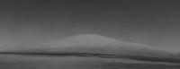
QUOTE (climber @ Aug 18 2012, 02:25 PM)  Stu (and all), can you please point out what you think will hidden our view?I'm trying to find the maximum altitude we'll see in order to match this with a similar view on Earth. It is actully difficult to find a view with ~ 5500m altitude difference, so if the real difference is much less, it'll make search easier and comparison real. Thanks all for you input. I think the best equivalent picture will be of Mauna Loa or Mauna Kea in Hawaii at a distance of about 20km from the summit. The altitude (~ 4000m) would be about right. I'll try to find that and see how it compares. Any better idea welcomed. climber 
-------------------- |
 |
 
|
|
Aug 18 2012, 06:10 PM
Post
#62
|
|
|
Founder Group: Chairman Posts: 14432 Joined: 8-February 04 Member No.: 1 |
It's just like any other mountain - you very rarely see the absolute summit till you're on it.
|
|
|
|
|
Aug 18 2012, 06:20 PM
Post
#63
|
||
 Senior Member Group: Members Posts: 4247 Joined: 17-January 05 Member No.: 152 |
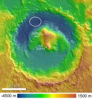
QUOTE (Tesheiner @ Aug 18 2012, 01:12 PM) here's a vertical profile of a line directly connecting the landing site to the summit and showing that it is out of the line of sight I thought that the true summit was farther south, more or less dead centre in Gale:
This elevation map and GM seem to agree that that's the highest point. Your summit corresponds to the "northern spur". Either way, both "local maxima" will likely remain out of sight for a very long time. Although the "true summit" is sharper, so it might be easier to see from afar... |
|
|
|
|
|
|
Aug 18 2012, 06:33 PM
Post
#64
|
||
 The Poet Dude Group: Moderator Posts: 5551 Joined: 15-March 04 From: Kendal, Cumbria, UK Member No.: 60 |
QUOTE (fredk @ Aug 18 2012, 07:20 PM) I thought that the true summit was farther south, more or less dead centre in Gale: That's what I'm going by, too...
-------------------- |
|
|
|
|
|
|
Aug 18 2012, 07:08 PM
Post
#65
|
|
|
Senior Member Group: Moderator Posts: 4279 Joined: 19-April 05 From: .br at .es Member No.: 253 |
Yeah, I was afraid of that.
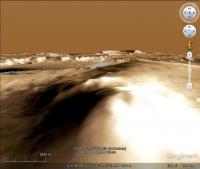
 QUOTE (elakdawalla @ Aug 18 2012, 05:49 PM) My version. As mentioned before, we need something as a sort of scale to give an idea of the size / distance: Liberty Statue, Eiffel Tower, Burj Dubai. |
|
|
|
|
Aug 18 2012, 07:47 PM
Post
#66
|
||
 Member Group: Members Posts: 691 Joined: 21-December 07 From: Clatskanie, Oregon Member No.: 3988 |
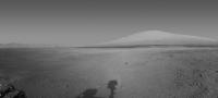
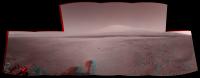
Ladies and Gentlemen....Mount Sharp from Navcam!

Ahh drats...Was already beatin to it.
|
|
|
|
|
|
|
Aug 18 2012, 07:51 PM
Post
#67
|
|
|
The Poet Dude Group: Moderator Posts: 5551 Joined: 15-March 04 From: Kendal, Cumbria, UK Member No.: 60 |
QUOTE (James Sorenson @ Aug 18 2012, 08:47 PM) Ladies and Gentlemen....Mount Sharp from Navcam! Where have you been? We got here hours ago!  Lovely image James. -------------------- |
|
|
|
|
Aug 18 2012, 07:55 PM
Post
#68
|
|
 Administrator Group: Admin Posts: 5172 Joined: 4-August 05 From: Pasadena, CA, USA, Earth Member No.: 454 |
QUOTE (James Sorenson @ Aug 18 2012, 11:47 AM) Ladies and Gentlemen....Mount Sharp from Navcam! Ahh drats...Was already beatin to it. Your sky is better than mine. I tried to remove vignetting with the filter in Photoshop but it was still imperfect, and the sky had a periodic darkening that I attempted to remove (with some but not complete success) with the dodge tool. How do you de-vignette the images? -------------------- My website - My Patreon - @elakdawalla on Twitter - Please support unmannedspaceflight.com by donating here.
|
|
|
|
|
Aug 18 2012, 08:07 PM
Post
#69
|
|
|
Member Group: Members Posts: 691 Joined: 21-December 07 From: Clatskanie, Oregon Member No.: 3988 |
QUOTE (Stu @ Aug 18 2012, 11:51 AM) Where have you been? We got here hours ago! Lovely image James. Obviously not on this planet...  Thank you Stu QUOTE (elakdawalla @ Aug 18 2012, 11:55 AM) How do you de-vignette the images? PTgui has an option for Vignetting Correction. |
|
|
|
|
Aug 18 2012, 08:11 PM
Post
#70
|
||
|
Founder Group: Chairman Posts: 14432 Joined: 8-February 04 Member No.: 1 |
It's been a long way, but we're here.
Attached thumbnail(s)
|
|
|
|
|
|
|
Aug 18 2012, 08:30 PM
Post
#71
|
|
|
Administrator Group: Admin Posts: 5172 Joined: 4-August 05 From: Pasadena, CA, USA, Earth Member No.: 454 |
OK, that's terrific. Since this is obviously so easy for you, can you please do it in stereo?
-------------------- My website - My Patreon - @elakdawalla on Twitter - Please support unmannedspaceflight.com by donating here.
|
|
|
|
|
Aug 18 2012, 08:43 PM
Post
#72
|
||
|
Founder Group: Chairman Posts: 14432 Joined: 8-February 04 Member No.: 1 |
Filling in the sky's not worth it - but I think this works.
(You were not expecting that were you One thing they probably didn't think of was the MER heritage for Navcam...carries over to experience of us amateurs stitching those Navcam images for 8 years )
Attached thumbnail(s)
|
|
|
|
|
|
|
Aug 18 2012, 09:34 PM
Post
#73
|
|
 Senior Member Group: Members Posts: 1619 Joined: 12-February 06 From: Bergerac - FR Member No.: 678 |
First, thank you Emily for publishing on your blog
Visits on my blog has rizing very fast  Second, I've updated my full panoramic with the Sol 12 Navcam pics. So now, Mount Sharp is not blur 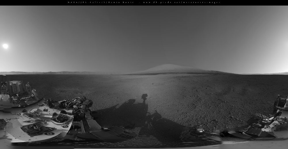
-------------------- |
|
|
|
|
Aug 18 2012, 10:31 PM
Post
#74
|
|
 Senior Member Group: Members Posts: 2492 Joined: 15-January 05 From: center Italy Member No.: 150 |
Excellent job, Damien... charmant!
 -------------------- I always think before posting! - Marco -
|
|
|
|
|
Aug 19 2012, 01:46 AM
Post
#75
|
|
|
Member Group: Members Posts: 315 Joined: 1-October 06 Member No.: 1206 |
OK, there's NO rigor on this, but I did want to raise the idea of comparing the scene of Mt Sharp with a terrestrial scene of similar vertical scale.
Here's a stock shot of Kilimanjaro, taken at I believe a roughly similar distance, side by side with a hasty colorised crop from Doug's post. The scales here aren't identical, but I think comparing portions of the Mastcams when they arrive with terrestrial scenes of similar scale will be very useful. The scale of Mt Hadley was really hard to process with Apollo 15 (no trees, streams, buildings, haze, normal signs of erosion etc to compare it with), here we have an atmosphere, but its still hard to really get a feel from the scale of the scene.  P |
|
|
|
|

|
Lo-Fi Version | Time is now: 22nd May 2024 - 04:35 PM |
|
RULES AND GUIDELINES Please read the Forum Rules and Guidelines before posting. IMAGE COPYRIGHT |
OPINIONS AND MODERATION Opinions expressed on UnmannedSpaceflight.com are those of the individual posters and do not necessarily reflect the opinions of UnmannedSpaceflight.com or The Planetary Society. The all-volunteer UnmannedSpaceflight.com moderation team is wholly independent of The Planetary Society. The Planetary Society has no influence over decisions made by the UnmannedSpaceflight.com moderators. |
SUPPORT THE FORUM Unmannedspaceflight.com is funded by the Planetary Society. Please consider supporting our work and many other projects by donating to the Society or becoming a member. |
|