Crossing the Dunes at Murray Buttes, Sites 54-62, Sols 1353-1659, May 28 2016-Apr 6 2017 |

  |
Crossing the Dunes at Murray Buttes, Sites 54-62, Sols 1353-1659, May 28 2016-Apr 6 2017 |
 Feb 20 2017, 10:54 PM Feb 20 2017, 10:54 PM
Post
#1066
|
|
|
Senior Member  Group: Members Posts: 2346 Joined: 7-December 12 Member No.: 6780 |
Out of the hip, I could offer four more hypotheses:
-1- In the upper left corner of the image at midnightplanets you refrenced, there appear to be remnants of an overlying (greyish) rock layer. This layer seems to be more resistant to erosion than the underlying (reddish) layer. The smaller grains may be other relics of the overlying layer. -2- The embedded grains may be sparse brecciated clusts in a sedimentary siltstone. -3- We are near hematite ridge. Depending of the composition of the embedded material, we might see first embedded iron ore fragments. -4- Embedded tektites of a meteorite; recently we have seen likely iron meteorites. |
 |
 
|
|
Feb 21 2017, 12:40 AM
Post
#1067
|
||
 Senior Member Group: Members Posts: 2425 Joined: 30-January 13 From: Penang, Malaysia. Member No.: 6853 |
Thank you all for sharing your hypotheses
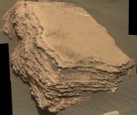
 I now have some more reading to do... I now have some more reading to do...Here is the sol 1614 3x3 R-MastCam mosaic of the layered block "Aroostook River" mentioned in the 1614-1616 USGS mission update. I cropped the edges a little and tweaked the jpeg compression to bring the file size within the upload limits. Edit: The block is ~53 cm wide Full resolution version LINK
|
|
|
|
|
|
|
Feb 21 2017, 01:02 AM
Post
#1068
|
|
 Member Group: Members Posts: 684 Joined: 24-July 15 Member No.: 7619 |
QUOTE (Gerald @ Feb 20 2017, 10:54 PM)  Out of the hip, I could offer four more hypotheses: -1- In the upper left corner of the image at midnightplanets you refrenced, there appear to be remnants of an overlying (greyish) rock layer. This layer seems to be more resistant to erosion than the underlying (reddish) layer. The smaller grains may be other relics of the overlying layer. -2- The embedded grains may be sparse brecciated clusts in a sedimentary siltstone. -3- We are near hematite ridge. Depending of the composition of the embedded material, we might see first embedded iron ore fragments. -4- Embedded tektites of a meteorite; recently we have seen likely iron meteorites. Well, the detail that interests me is the knobby texture, e.g. in contrast to smooth "blueberries" I'd call these mulberries. They appear to have internal structure, you can see where a 'pip' has weathered out and left a spherical gap. This makes it look like these are clumps of course grained material cemented by a fine matrix. |
|
|
|
|
Feb 21 2017, 01:52 AM
Post
#1069
|
|
|
Member Group: Members Posts: 306 Joined: 4-October 14 Member No.: 7273 |
QUOTE (HSchirmer @ Feb 20 2017, 08:02 PM) Well, the detail that interests me is the knobby texture, e.g. in contrast to smooth "blueberries" I'd call these mulberries. They appear to have internal structure, you can see where a 'pip' has weathered out and left a spherical gap. This makes it look like these are clumps of course grained material cemented by a fine matrix. You can't really say much about their internal structure since we don't have any that have cracked open. The knobby texture could just be a consequence of uneven precipitation. They don't look all that different from iron oxide concretions to me. |
|
|
|
|
Feb 21 2017, 05:47 AM
Post
#1070
|
|
|
Senior Member Group: Members Posts: 1043 Joined: 17-February 09 Member No.: 4605 |
QUOTE (jccwrt @ Feb 19 2017, 08:52 PM) Looks like there's a multi-stage history in that rock. I notice that many of the white veins (probably gypsum) don't have the alteration haloes around them. So it looks to me like there was initial fracturing associated with the movement of a reducing agent that bleached the iron, followed by fracturing not associated with a fluid. Not sure how the v-shaped vein fits into that history, though. I believe you're correct in that there has been multiple instances of alteration/deposition through fractures. The thing is that if we accept that the sediment in Gale is horizontally bounded then if the initial fracturing was hydraulic, with high overburden pressure, hydraulic fracturing would be preferentially horizontal. As overburden was eroded and removed, pressure release would be vertical. It could be anticipated that there would be reactivation and extension of fractures over time which would account for those thin offshoots that seem to have Calcium sulphate deposits but no dark halo. It also accounts for the horizontal deposits without necessitating an evaporate, playa scenario. |
|
|
|
|
Feb 21 2017, 09:29 AM
Post
#1071
|
|||
|
Senior Member Group: Members Posts: 2425 Joined: 30-January 13 From: Penang, Malaysia. Member No.: 6853 |
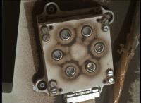
REMS UV Detector Housing in this 1614 MAHLI and a montage with a little history.
We can see the recent cleaning of the finer dust from around the magnets and the darker sands on the deck, I've annotated the sol # and a brief description under each image. Once again reduced to meet the max upload limits. Probably make a good GIF one day, but the file size may be a little on the large size and the alignment is not very consistent.
|
||
|
|
|
||
|
Feb 21 2017, 08:51 PM
Post
#1072
|
||
|
Senior Member Group: Members Posts: 2817 Joined: 22-April 05 From: Ridderkerk, Netherlands Member No.: 353 |
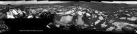
The Navcam L Panoramic view on Sol 1616.
Jan van Driel
|
|
|
|
|
|
|
Feb 22 2017, 06:15 AM
Post
#1073
|
||
|
Senior Member Group: Members Posts: 2425 Joined: 30-January 13 From: Penang, Malaysia. Member No.: 6853 |
Preview of the a de-bayered 1609 R-MastCam mosaic of Ireson Hill, using 30 of the 32 frames. I plan to assemble the full mosaic when the remaining frames are downlinked.
De-bayered in ImageJ, stitched in MS ICE. The greenish cast from de-bayering these files, has not been adjusted in this preview version
|
|
|
|
|
|
|
Feb 22 2017, 02:38 PM
Post
#1074
|
||
|
Solar System Cartographer Group: Members Posts: 10146 Joined: 5-April 05 From: Canada Member No.: 227 |
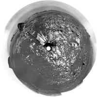
A very small move on sol 1616, less than a wheel diameter from comparison of Hazcams. The drive was supposed to be bigger, so presumably halted by tilt or other sensors. I will not update the map for it, but here is Jan's recent panorama in circular form.
Phil
PS "Here is the sol 1614 3x3 R-MastCam mosaic of the layered block "Aroostook River" mentioned in the 1614-1616 USGS mission update. " I always wondered what happened to cousin Aroo. -------------------- ... because the Solar System ain't gonna map itself.
Also to be found posting similar content on https://mastodon.social/@PhilStooke NOTE: everything created by me which I post on UMSF is considered to be in the public domain (NOT CC, public domain) |
|
|
|
|
|
|
Feb 22 2017, 04:51 PM
Post
#1075
|
||
|
Solar System Cartographer Group: Members Posts: 10146 Joined: 5-April 05 From: Canada Member No.: 227 |
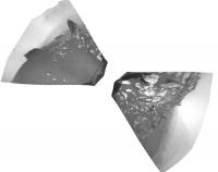
Reprojected Hazcams from sol 1617 show we are now on the sand, a short distance south of the previous position. Map update this evening my time.
Phil
(approximate orientation only) -------------------- ... because the Solar System ain't gonna map itself.
Also to be found posting similar content on https://mastodon.social/@PhilStooke NOTE: everything created by me which I post on UMSF is considered to be in the public domain (NOT CC, public domain) |
|
|
|
|
|
|
Feb 23 2017, 06:00 AM
Post
#1076
|
|
|
Senior Member Group: Members Posts: 1043 Joined: 17-February 09 Member No.: 4605 |
Phil Stooke's map stop 2 (current position) is at the channel through the dunes, so the reason for the seven sol diversion to the dunes (stop 1) with a short 2 sol layover remains something of a mystery. There must be something that caught the teams interest.
|
|
|
|
|
Feb 23 2017, 01:33 PM
Post
#1077
|
|
|
Member Group: Members Posts: 923 Joined: 10-November 15 Member No.: 7837 |
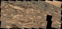
Sol 1617 Navcam right pano with extended sky
 -------------------- |
|
|
|
|
Feb 23 2017, 02:11 PM
Post
#1078
|
|
|
Member Group: Members Posts: 684 Joined: 24-July 15 Member No.: 7619 |
QUOTE (serpens @ Feb 23 2017, 07:00 AM) Phil Stooke's map stop 2 (current position) is at the channel through the dunes, so the reason for the seven sol diversion to the dunes (stop 1) with a short 2 sol layover remains something of a mystery. There must be something that caught the teams interest. Eh, looks like the rover ran over and cracked open a fair sized rock, bottom right of the navcam image. Might be worth checking out fresh fracture faces to see how they compare to the weathered exterior... |
|
|
|
|
Feb 23 2017, 03:35 PM
Post
#1079
|
|
 Senior Member Group: Members Posts: 4246 Joined: 17-January 05 Member No.: 152 |
QUOTE (serpens @ Feb 23 2017, 07:00 AM) the reason for the seven sol diversion to the dunes (stop 1) with a short 2 sol layover remains something of a mystery. In the latest update they say they wanted to compare the leading and trailing edges of the dunes. (Or do they mean they'll do both near here, rather than comparing stops 1 and 2?) |
|
|
|
|
Feb 23 2017, 09:50 PM
Post
#1080
|
|
|
Senior Member Group: Members Posts: 1043 Joined: 17-February 09 Member No.: 4605 |
From the update " This site was selected to enable comparison of the leading and trailing edges of the dunes." implies this is a specific task for this stop. Could there be a delay on the requirement to have an extended stop for attempts at fault rectification on the drill?
I still have difficulty thinking of this area as dunes rather than ripples. |
|
|
|
|

|
Lo-Fi Version | Time is now: 20th April 2024 - 12:15 AM |
|
RULES AND GUIDELINES Please read the Forum Rules and Guidelines before posting. IMAGE COPYRIGHT |
OPINIONS AND MODERATION Opinions expressed on UnmannedSpaceflight.com are those of the individual posters and do not necessarily reflect the opinions of UnmannedSpaceflight.com or The Planetary Society. The all-volunteer UnmannedSpaceflight.com moderation team is wholly independent of The Planetary Society. The Planetary Society has no influence over decisions made by the UnmannedSpaceflight.com moderators. |
SUPPORT THE FORUM Unmannedspaceflight.com is funded by the Planetary Society. Please consider supporting our work and many other projects by donating to the Society or becoming a member. |
|