

T36 (Oct 02, 2007) |

  |
T36 (Oct 02, 2007) |
 Sep 27 2007, 07:24 PM Sep 27 2007, 07:24 PM
Post
#1
|
|
 Member  Group: Members Posts: 213 Joined: 21-January 07 From: Wigan, England Member No.: 1638 |
The mission flyby description is now up.
975 km altitude, focusing on the southern hemisphere, lots of RADAR observations including a bit of SAR... -------------------- "I got a call from NASA Headquarters wanting a color picture of Venus. I said, What color would you like it? - Laurance R. Doyle, former JPL image processing guy
|
 |
 
|
|
Sep 28 2007, 12:51 AM
Post
#2
|
|
|
Merciless Robot Group: Admin Posts: 8783 Joined: 8-December 05 From: Los Angeles Member No.: 602 |
(sigh)...thanks for doing that, Del, was gonna do the same thing. (The sigh was missing Alex...)
-------------------- A few will take this knowledge and use this power of a dream realized as a force for change, an impetus for further discovery to make less ancient dreams real.
|
|
|
|
|
Sep 29 2007, 07:19 PM
Post
#3
|
|
|
Member Group: Members Posts: 624 Joined: 10-August 05 Member No.: 460 |
These passes with lots of radar, gravity measurements and the like, are not nearly as immediately gratifying as the visual passes. But long term, we will learn more about the nature of the moons and the Saturn system.
|
|
|
|
|
Sep 30 2007, 12:28 AM
Post
#4
|
|
|
Member Group: Members Posts: 813 Joined: 29-December 05 From: NE Oh, USA Member No.: 627 |
I think the RADAR passes are the best. Granted we have to wait for processed data. But the SAR imaging always blows me away.
All the previous northern passes revealed the Titan winter lakes district. What will all these southern passes reveal? Now we know that liquid hydrocarbons condense out in the long northern dark.... what as been going on down south during the long southern summer? Soon we will know. Glorious. Craig |
|
|
|
|
Sep 30 2007, 11:41 PM
Post
#5
|
|
 Member Group: Members Posts: 610 Joined: 23-February 07 From: Occasionally in Columbia, MD Member No.: 1764 |
QUOTE (belleraphon1 @ Sep 29 2007, 08:28 PM)  I think the RADAR passes are the best. No disagreement there from me, although overall balance is important QUOTE All the previous northern passes revealed the Titan winter lakes district. ........ Now we know that liquid hydrocarbons condense out in the long northern dark.... what as been going on down south during the long southern summer? Actually I put it to you that we know no such thing. We 'know' (= 'are pretty sure that') there are liquid hydrocarbons in northern lakes, and there is evidence that the lake level changes. However, it is by no means certain that there are appreciable lake level changes on seasonal timescales - could be mostly ethane slowly accumulating on geological timescales, with methane merely tracking the ethane. And if there are seasonal lake changes, it isnt obvious that there is accumulation in winter - after all, the rate of pan evaporation on Earth is higher in winter (windier, and dryer air - even though the precipitation is typically higher - it is precipitation minus evaporation that matters) It's going to be fun to see the south (though T36 probably wont be far enough south to see lakes if they are distributed in mirror image to the north) in future passes and trying to figure this all out.... R |
|
|
|
|
Oct 1 2007, 01:18 AM
Post
#6
|
|
|
Member Group: Members Posts: 813 Joined: 29-December 05 From: NE Oh, USA Member No.: 627 |
Thanks for the correction rlorenz....
Very true that it is premature to jump to conclusions regarding seasonal effects. After all, we have not observed Titan over an entire seasonal cycle, nor will we in the near future. Been eagerly awaiting these southern passes. And I do not mean to negate the other instrument passes...... correct me if I am wrong, but RADAR cannot see the clouds, while VIMS can hint at composition. What exciting times we live in. Fun indeed! Craig |
|
|
|
|
Oct 1 2007, 09:15 AM
Post
#7
|
|
|
Senior Member Group: Members Posts: 1870 Joined: 20-February 05 Member No.: 174 |
The radar data frustrates the <expletive deleted> out of me, cause it's clear you really need much better than 100 meter resolution to really see the important geological details in most terrains. A future orbiter should plan to map all of Titan at 100 meter resolution, at worst, with sample capability <and the ability to build up local high-rez maps -- the whole return ultimately bandwidth-to-earth limited> at better than 25 meter resolution.
Of course, the CCD imaging frustrates me more, as we need a framing color camera with the same resolution in the 1.5 to 5 micrometer middle infrared. Impossible when Cassini was being built, possible now. We just can't see Titan's surface well enough, but we can see enough to make agonized progress and with swear-buckets full of qualifications. We're gonna have to make do for now. It's just that simple. |
|
|
|
|
Oct 1 2007, 04:24 PM
Post
#8
|
|
 Senior Member Group: Members Posts: 3419 Joined: 9-February 04 From: Minneapolis, MN, USA Member No.: 15 |
QUOTE (edstrick @ Oct 1 2007, 04:15 AM) Impossible when Cassini was being built, possible now. Testimony to how it's just not possible to design a one-size-fits-all interplanetary probe, mix up the sensors a bit, and fly the same thing to a different place every few years. It's not just a matter of pulling one camera off and sticking another one on -- changing camera technology means changes to signal conditioning, data processing, transmission encoding, etc., etc. And that's not even considering the advances made from year to year in each of *those* technologies, either. These things are designed to do certain things as efficiently as possible with not a milligram more mass than is absolutely necessary to do those things. That means they have to be specially designed to their tasks, each one unique to its mission. If we were flying five to ten a year, an adjustable one-size-fits-all approach might work. But for flagship missions that fly every five to ten years? Nope. -the other Doug -------------------- The trouble ain't that there is too many fools, but that the lightning ain't distributed right. -Mark Twain
|
|
|
|
|
Oct 3 2007, 10:27 PM
Post
#9
|
|
|
Member Group: Members Posts: 213 Joined: 21-January 07 From: Wigan, England Member No.: 1638 |
|
|
|
|
|
Oct 6 2007, 04:04 AM
Post
#10
|
|
 Senior Member Group: Members Posts: 1887 Joined: 20-November 04 From: Iowa Member No.: 110 |
Some more images are up. This one is interesting.
http://saturn.jpl.nasa.gov/multimedia/imag...4/N00093734.jpg |
|
|
|
|
Oct 6 2007, 05:06 AM
Post
#11
|
|
 Senior Member Group: Members Posts: 2530 Joined: 20-April 05 Member No.: 321 |
QUOTE (edstrick @ Oct 1 2007, 02:15 AM) The radar data frustrates the <expletive deleted> out of me, cause it's clear you really need much better than 100 meter resolution to really see the important geological details in most terrains. A future orbiter should plan to map all of Titan at 100 meter resolution, at worst, with sample capability <and the ability to build up local high-rez maps -- the whole return ultimately bandwidth-to-earth limited> at better than 25 meter resolution. Maybe tough to do, given that the thick atmosphere and huge scale height forces any orbiter to stay at a fairly high altitude. Given the funding parameters, I don't think we'll see a Titan orbiter as the next mission there. I think it'll be an aerobot that observes from altitude along a long ground track (thousands of km), then sets down once on the terrain of choice and performs surface studies. Even better would be an aerobot that could make two or more surface stops, flying downwind each time. But that would be pricier. That would provide very limited coverage, but very high resolution, with the hope that the track would cover representative terrains. Unfortunately, the northern lakes and the equatorial sand seas seem to be difficult to connect in one "trajectory" with the east-west Titanian winds. If a single terrain had to be chosen for the next touchdown, it would probably be any sediment-rich area near the northern lakes that is not currently below the fluid line. The cheapest mission plans for Titan run up estimates of approximately $1.6B, so any landed mission arriving also with an orbiter would run close to $3B. Nothing's going to be cheap where Titan exploration is concerned. Drat it. |
|
|
|
|
Oct 6 2007, 12:34 PM
Post
#12
|
|
 Senior Member Group: Members Posts: 3648 Joined: 1-October 05 From: Croatia Member No.: 523 |
Narrow angle T36 mosaic at 2/3 original size, click to enlarge:
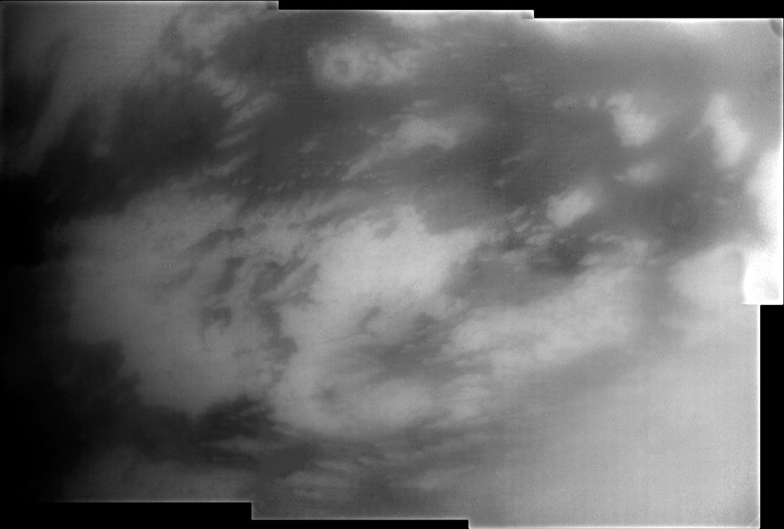 Further enhancement, 1/2 original size:  I don't think there's much more to pull out of the raws than this. Context for the mosaic: 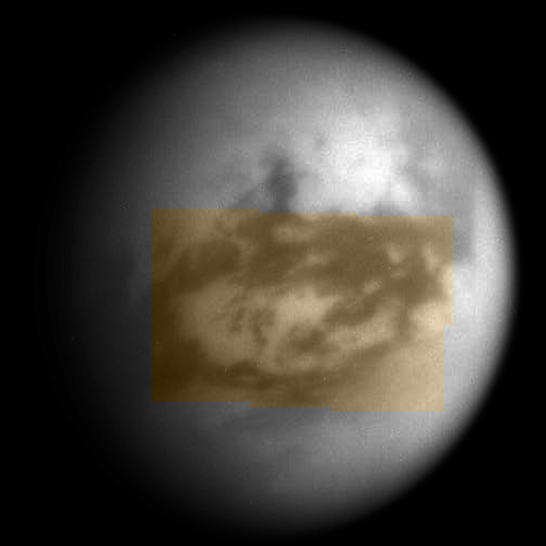
-------------------- |
|
|
|
|
Oct 6 2007, 01:24 PM
Post
#13
|
|
|
Member Group: Members Posts: 610 Joined: 23-February 07 From: Occasionally in Columbia, MD Member No.: 1764 |
QUOTE (JRehling @ Oct 6 2007, 01:06 AM) Given the funding parameters, I don't think we'll see a Titan orbiter as the next mission there. I think it'll be an aerobot that observes from altitude along a long ground track (thousands of km), then sets down once on the terrain of choice and performs surface studies. Even better would be an aerobot that could make two or more surface stops, flying downwind each time. But that would be pricier. One word to you : bandwidth. An orbiter is the key element in any architecture - since Titan has so much to explore, there is no single question to be posed to which there is a 1 bit, or 1 Gb answer - you want to send Tb back, and that is hard without an orbiter as a relay. So you start with an orbiter (which can, over 4 years, attain global coverage at 100m by SAR and at 2 microns) and add cool bits from there. I am pretty warmed-up on these questions - we (the APL/JPL/etc team) had our site visit from the NASA review panel for the Flagship study - I myself got grilled for 3 hours..... Flagship study reports should be released in the next month or so - that should explain everything. |
|
|
|
|
Oct 6 2007, 08:11 PM
Post
#14
|
|
|
Newbie Group: Members Posts: 18 Joined: 1-July 05 Member No.: 425 |
stitched semi flat fielded images with various contrast skews for visual interest:
http://i225.photobucket.com/albums/dd78/al.../weirdorama.jpg |
|
|
|
|
Oct 7 2007, 07:27 PM
Post
#15
|
|
|
Senior Member Group: Members Posts: 3516 Joined: 4-November 05 From: North Wales Member No.: 542 |
I thought the best ISS detail of the Huygens landing site was due to be taken on T35, and indeed there were some good ones there, but now it seems we have even better ones from T36. Does anyone know if this results from a change of plan or did I just misunderstand the plan in the first place? (Not important - just curious. I'm equally delighted to see them whenever they arrived!)
|
|
|
|
|

|
Lo-Fi Version | Time is now: 25th April 2024 - 04:41 AM |
|
RULES AND GUIDELINES Please read the Forum Rules and Guidelines before posting. IMAGE COPYRIGHT |
OPINIONS AND MODERATION Opinions expressed on UnmannedSpaceflight.com are those of the individual posters and do not necessarily reflect the opinions of UnmannedSpaceflight.com or The Planetary Society. The all-volunteer UnmannedSpaceflight.com moderation team is wholly independent of The Planetary Society. The Planetary Society has no influence over decisions made by the UnmannedSpaceflight.com moderators. |
SUPPORT THE FORUM Unmannedspaceflight.com is funded by the Planetary Society. Please consider supporting our work and many other projects by donating to the Society or becoming a member. |
|


