Printable Version of Topic
Click here to view this topic in its original format
Unmanned Spaceflight.com _ New Horizons _ A glimpse into the topography of the farside of Pluto
Posted by: TrappistPlanets Oct 29 2021, 10:33 PM
i did some heavy detail enhancement/extraction to this image below
i figured out timing (around midnight EDT on July 15) of the image (after doing some research) and figured out the location of the south pole (with the help of Celesta), than i did additional modifications and aliments to get the below
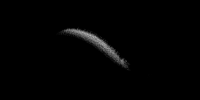
|
also blended it with a already existing map (i also added in the charonshine stuff too (see https://arxiv.org/abs/2110.11976 ) chopped outoversaturated areas)


i am also wondering if anyone else has detail extracted crescent images i can cooperate into the maps above, plus i also could use feedback/consent on the above from the scientists/experts here
Posted by: Floyd Oct 29 2021, 11:28 PM
There were some fine image results from the New Horizons team working with some of the departing images showing the terminator. Details were recovered from the faintly lit terminator. You need to go through the threads covering the NH post Pluto encounter.
I'm afraid what you have pulled out looks like noise only to me.
Posted by: TrappistPlanets Oct 29 2021, 11:36 PM

I'm afraid what you have pulled out looks like noise only to me.
i think its more than noise
this here looks a lot like a possible crater
 you can see a crater rim and a central peak
that is not in the low resolution data in already existing pluto maps
--EDITED TO CHANGE TONE OF MESSAGE, so i am not giving a very strong claim--
Posted by: djellison Oct 30 2021, 02:58 AM
That's a very strong claim for very tenuous data.
'Could be interpreted as...' is as far as you should reasonably go.
Posted by: TrappistPlanets Oct 30 2021, 11:33 AM
'Could be interpreted as...' is as far as you should reasonably go.
so would that be a crater, or is that just noise shaped like a crater, also some of the possible topography lines up with the lower resolution data
Posted by: TrappistPlanets Oct 30 2021, 02:00 PM
i'll try blurring, and noise reducing the heck out of the original image than try to extract surface details, to see if i get the same result (ie, that possible crater, and the other stuff)
--EDIT--
i just tried a 2nd attempt, witch is the image below (blurred it to reduce some noise a bit)
here is the original attempt
comparing these i do see some correlations (like that "crater" i pointed out , its a bit hard to see in attempt 2 though)
Posted by: PDP8E Oct 30 2021, 04:13 PM
Trappist! I admire your ideas and persistence!
When curiosity grabs you, keep going. You never know what might happen.
The New Horizons team also came up with the same idea as yours and has been working on it.
They probably have access to higher resolution original images to work with... 
Here is their paper with some of their results and images of the Dark Side of Pluto
(you might recognize a few names ...)
https://iopscience.iop.org/article/10.3847/PSJ/ac2743/pdf
Posted by: Antdoghalo Oct 30 2021, 04:19 PM
There's barely anything but I can discern a part of the farside "reindeer" antlers if your map is correct. This area has been mapped in greater more resolved detail on approach though. Much of this process has been gone through and added into maps, though the USGS map has not been updated to included atmosphere lit areas and they do not include hubble or night shine in their maps.
Posted by: TrappistPlanets Oct 30 2021, 05:14 PM
"This area has been mapped in greater more resolved detail on approach though"
yes for color and just the overall look of the thing, but in terms of shadows, we didn't get good shadows, its like they weren't even there or the area is flat in the images (witch can be used to determine if the thing is a big crack or a huge mountain witch can help us understand Pluto's antlers a lot better
|
--EDIT--
does anyone have the full resolution (at full resolution, and the whole image) of the image the 3 smaller images at the bottom of this fig came from, i can see some clearly visible far-side terrain even without any editing to brightness

there is probably even more terrain that we can pull out from the haze, if we can pull this much stuff from Pluto's haze beyond the terminator

we should be able to pull out farside terrain from crescent images posted in this thread
Powered by Invision Power Board (http://www.invisionboard.com)
© Invision Power Services (http://www.invisionpower.com)