The Top of Vera Rubin Ridge Part 1, Site 66-67, sol 1812-1943, 11 Sep 2017-23 Jan 2018 |

  |
The Top of Vera Rubin Ridge Part 1, Site 66-67, sol 1812-1943, 11 Sep 2017-23 Jan 2018 |
 Dec 5 2017, 12:23 AM Dec 5 2017, 12:23 AM
Post
#196
|
||
|
Solar System Cartographer  Group: Members Posts: 10151 Joined: 5-April 05 From: Canada Member No.: 227 |
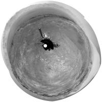
Yes, that is a beautiful view. Here is Damia's panorama in circular form. There are lots of circular depressions around here, presumably small impact craters.
Phil
-------------------- ... because the Solar System ain't gonna map itself.
Also to be found posting similar content on https://mastodon.social/@PhilStooke Maps for download (free PD: https://upload.wikimedia.org/wikipedia/comm...Cartography.pdf NOTE: everything created by me which I post on UMSF is considered to be in the public domain (NOT CC, public domain) |
|
 |
 
|
|
|
Dec 5 2017, 08:03 AM
Post
#197
|
|
|
Senior Member Group: Members Posts: 1043 Joined: 17-February 09 Member No.: 4605 |
There doesn't seem to have been any progress on the drill since late October. Given that the hematite ridge is a reasonably important area for analysis can we assume that the non stabilised test on the drill function was unsuccessful?
|
|
|
|
|
Dec 5 2017, 09:52 AM
Post
#198
|
||
 Senior Member Group: Members Posts: 2428 Joined: 30-January 13 From: Penang, Malaysia. Member No.: 6853 |
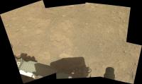
Sol 1894 Workspace (raw L-MastCam assembled in MS ICE) contains several of the targets located above the shadow of Curiosity's mast that were mentioned in the latest plan
|
|
|
|
|
|
|
Dec 5 2017, 11:04 AM
Post
#199
|
||
|
Senior Member Group: Members Posts: 2428 Joined: 30-January 13 From: Penang, Malaysia. Member No.: 6853 |
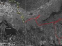
QUOTE (serpens @ Dec 5 2017, 04:03 PM)  There doesn't seem to have been any progress on the drill since late October.... Measuring what remains of the Mount Sharp Ascent Route (MSAR) using Fernando's GE Map, there is a small loop that takes the rover a little way east before doubling back to the down ramp. From the current location the remaining path is just over one kilometer long, so unless they deviate from the plan and head straight for the down ramp we may still have plenty of time for JPL to work on the drill before dropping down onto the 'Clay' deposits that await beyond the ridge. (Fingers crossed) See GE screen capture:
|
|
|
|
|
|
|
Dec 5 2017, 01:56 PM
Post
#200
|
|
|
Member Group: Members Posts: 122 Joined: 19-June 07 Member No.: 2455 |
|
|
|
|
|
Dec 5 2017, 09:42 PM
Post
#201
|
|
|
Member Group: Members Posts: 180 Joined: 31-January 05 From: Brittany (France) Member No.: 164 |
[quote name='Ant103' date='Dec 4 2017, 01:25 PM' post='237857']
This panorama taken on Sol 1894 is just incredible. Like we could touch the hills ! Magnifique encore Damia merci -------------------- Erwann |
|
|
|
|
Dec 5 2017, 11:05 PM
Post
#202
|
|
|
Senior Member Group: Members Posts: 3516 Joined: 4-November 05 From: North Wales Member No.: 542 |
QUOTE (Phil Stooke @ Dec 5 2017, 01:23 AM) Yes, that is a beautiful view. Here is Damia's panorama in circular form. We seem to be high enough now to see some mountains beyond the northern crater rim. They are at about 11:30 on that circular projection. Does anyone have a handy map of what's out there? Presumably we'll see more as we continue climbing, weather permitting. |
|
|
|
|
Dec 6 2017, 02:58 AM
Post
#203
|
|
 Administrator Group: Admin Posts: 5172 Joined: 4-August 05 From: Pasadena, CA, USA, Earth Member No.: 454 |
QUOTE (serpens @ Dec 5 2017, 12:03 AM) There doesn't seem to have been any progress on the drill since late October. Given that the hematite ridge is a reasonably important area for analysis can we assume that the non stabilised test on the drill function was unsuccessful? Don't conclude that. It's just a very, very slow process. Drilling is only half the problem; delivering to the instruments is another equally difficult problem. In the meantime, they're driving when they can before AGU, Christmas, and New Year's. -------------------- My website - My Patreon - @elakdawalla on Twitter - Please support unmannedspaceflight.com by donating here.
|
|
|
|
|
Dec 6 2017, 03:21 AM
Post
#204
|
|
|
Solar System Cartographer Group: Members Posts: 10151 Joined: 5-April 05 From: Canada Member No.: 227 |
"We seem to be high enough now to see some mountains beyond the northern crater rim. They are at about 11:30 on that circular projection. Does anyone have a handy map of what's out there?"
http://www.unmannedspaceflight.com/index.p...mp;#entry236966 Phil -------------------- ... because the Solar System ain't gonna map itself.
Also to be found posting similar content on https://mastodon.social/@PhilStooke Maps for download (free PD: https://upload.wikimedia.org/wikipedia/comm...Cartography.pdf NOTE: everything created by me which I post on UMSF is considered to be in the public domain (NOT CC, public domain) |
|
|
|
|
Dec 6 2017, 09:28 AM
Post
#205
|
||
|
Senior Member Group: Members Posts: 2428 Joined: 30-January 13 From: Penang, Malaysia. Member No.: 6853 |
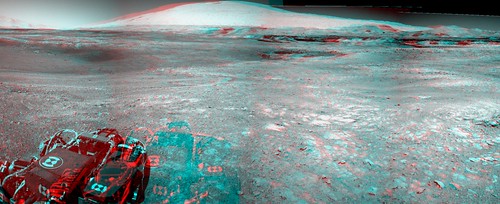
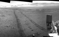
MS ICE made a pigs ear out of the 1896 NavCams, but the tracks came out well

|
|
|
|
|
|
|
Dec 6 2017, 12:33 PM
Post
#206
|
|
 Senior Member Group: Members Posts: 1619 Joined: 12-February 06 From: Bergerac - FR Member No.: 678 |
Thank you everyone for your kind messages
Here is Sol 1896 Navcam pan. Again, spectacular view there. 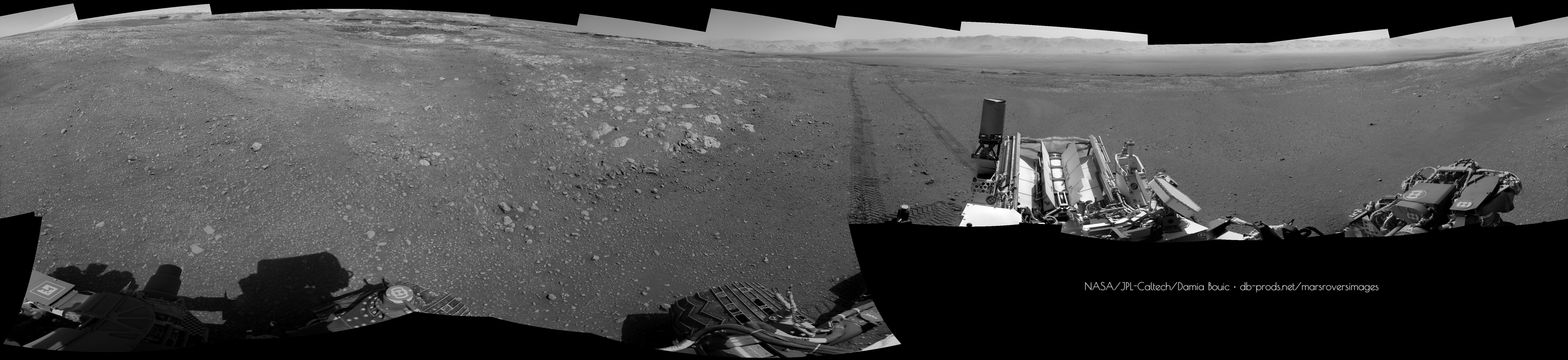
-------------------- |
|
|
|
|
Dec 6 2017, 06:27 PM
Post
#207
|
||
|
Solar System Cartographer Group: Members Posts: 10151 Joined: 5-April 05 From: Canada Member No.: 227 |
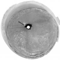
Thanks, Damia - here is a circular version to show our location in the crater-like depression
Phil
-------------------- ... because the Solar System ain't gonna map itself.
Also to be found posting similar content on https://mastodon.social/@PhilStooke Maps for download (free PD: https://upload.wikimedia.org/wikipedia/comm...Cartography.pdf NOTE: everything created by me which I post on UMSF is considered to be in the public domain (NOT CC, public domain) |
|
|
|
|
|
|
Dec 8 2017, 12:46 AM
Post
#208
|
||
 Member Group: Members Posts: 684 Joined: 24-July 15 Member No.: 7619 |
QUOTE (PaulH51 @ Dec 6 2017, 10:28 AM) MS ICE made a pigs ear out of the 1896 NavCams, but the tracks came out well
Is the rover "crabbing" for some reason? The left side tracks seem substantially wider than right side? Not just parallax, but what seems to be considtent 1.5x or 2x tread width on the left, but 1.5x or 1.0x on the right? |
|
|
|
|
|
|
Dec 8 2017, 05:00 PM
Post
#209
|
|
|
Senior Member Group: Members Posts: 2346 Joined: 7-December 12 Member No.: 6780 |
On one track, the three wheels seem to be pretty well aligned, while on the other track they seem to be displaced by almost the width of a wheel, resulting in a wider track.
I could only speculate about the reason for the different horizontal displacements with respect to the driving direction. Might be some lateral slip due to the slope and sandy ground. |
|
|
|
|
Dec 8 2017, 07:54 PM
Post
#210
|
|
|
Administrator Group: Admin Posts: 5172 Joined: 4-August 05 From: Pasadena, CA, USA, Earth Member No.: 454 |
One way to do that would be if the track were not straight but actually had a constant curvature bent slightly to the rover's right. The middle wheels are positioned about half a wheel width outside the corner wheels. A slightly curved track would put the tracks from the wheels on the outside of the turn on top of each other, but would displace the track of the middle wheel on the inside of the turn off of the path of the corner wheels.
-------------------- My website - My Patreon - @elakdawalla on Twitter - Please support unmannedspaceflight.com by donating here.
|
|
|
|
|

|
Lo-Fi Version | Time is now: 25th April 2024 - 12:27 PM |
|
RULES AND GUIDELINES Please read the Forum Rules and Guidelines before posting. IMAGE COPYRIGHT |
OPINIONS AND MODERATION Opinions expressed on UnmannedSpaceflight.com are those of the individual posters and do not necessarily reflect the opinions of UnmannedSpaceflight.com or The Planetary Society. The all-volunteer UnmannedSpaceflight.com moderation team is wholly independent of The Planetary Society. The Planetary Society has no influence over decisions made by the UnmannedSpaceflight.com moderators. |
SUPPORT THE FORUM Unmannedspaceflight.com is funded by the Planetary Society. Please consider supporting our work and many other projects by donating to the Society or becoming a member. |
|