Soviet M71 and M73 landing point selections, Unraveling landing site selections Mars 2,3,6 and 7 |

  |
Soviet M71 and M73 landing point selections, Unraveling landing site selections Mars 2,3,6 and 7 |
 May 6 2009, 08:40 AM May 6 2009, 08:40 AM
Post
#1
|
||||
 Member  Group: Members Posts: 236 Joined: 5-June 08 From: Udon Thani Member No.: 4185 |
Sorry, this is a long post and only interesting for some weird space historians like myself ;-)
What I have been trying to do is make sense of the landing site selections for the Soviet Mars 2, 3, 6 and 7 landers from a mathematical point of view. In other topics it has been shown that the Soviets used Mariner images to plan the landing sites, and a lot has been written on the technical aspects of these missions, but not much has been written about why a certain landing site was selected and which were the constraints on landing. Given the completely automated and pre-set landing sequence it looks like the M71 and M73 landers were very constrained in their landing sites, they could only land at a few pre-defined spots and there was only very limited room to alter a landing point once the craft was launched. If I calculate the situation at the time of Mars 3 and Mars 6 touch down I get the following situation:
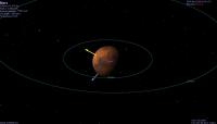
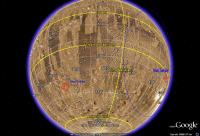
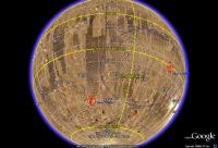
for Mars 3
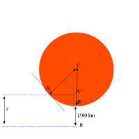
for Mars 6. Both images are remarkably similar. In both images the direction of the sun is shown as the yellow vector, the grey vector marks the motion of Mars, and the red mark shows the landing site. It can be shown that both craft: 1) Landed in the local afternoon (Mars 3: 15:52 LMT and Mars 6: 15:12 LMT) 2) Landed at a latitude below the suns declination (Mars 2 and 3: 25 deg below suns declination, Mars 6: 32 deg) Data as I calculate it: CODE Probe Lat Sun Decl Diff Lon Sun GHA Diff LMT Mars 2 44 S 20 S -24 58 E Mars 3 45 S 20 S -25 158 W 144 E 58 W 15:52:00 Mars 6 24 S 8 N -32 19 W 67 W 48 W 15:12:00 Mars 7 50 S ? 8 N -57 28 W ? For Mars 2 and Mars 7 I did not (yet?) find exact data on UTC time of closest approach to Mars, so I could not calculate the Sun GHA and local mars time. Mars 7 is the odd one, the latitude of 50 S does not seem to make sense as it is much farther south then all the other landers, however as Mars 7 missed Mars altogether the location of its intended landing site seems disputable. For Mars 2 and 3 the latitude of the landing point also relates to the inclination of the final orbit of the mothership (Mars 6 and 7 were fly by missions, however the Mars 6 location relates to the inclination of the Mars 5 orbiter). I am not yet completely sure why it was apparently necessary to land at a latitude 25-30 degrees below the suns declination, but a landing in the local afternoon seems to make sense. If I calculate the trajectory backwards, then separation of the lander from the mothership was almost at local noon, in other words the spacecraft was almost exactly between Mars and the Sun at the moment of release. I have the feeling that this was required for three reasons: 1) It is mentioned that the automatic navigation system used angle measurements of Mars to calculate the trajectory and to time the moment of release, for angle measurements it is easiest if you have a 'full Mars'. 2) On release of the lander, the spacecraft had to be oriented perpendicular to the flight path, while it is mentioned that it was stabilized using the Sun and the star Canopus. This works only if the craft is between Mars and the Sun, then if you point the sun sensor (and solar panels) at the sun you are already perpendicular to the flightpath. 3) After release and the firing of its solid propellant engine, the lander was oriented with its heatshield pointing in the direction of flight and then spin stabilized for the cruise to Mars. Once again, this works easiest if the craft is almost in between Mars and the sun, you only need to point the spin axis at the sun and the craft will be stabilized with the heatshield in the correct direction! Remember this was all a completely automated procedure, the lander used gunpowder engines both for the separation burn and for the orientation so everything was completely pre-set, it only worked if conditions were exactly as calculated prior launch of the craft. Once the lander was released there was no more 'steering' or anything, the whole further sequence was completely pre-set and ballistic. I have not yet completely worked out these constraints, but it looks like the M71 and M73 landers were extremely constrained in their landing sites, the latitude of the landing site was probably completely fixed and longitude was defined by arrival time at Mars, which also could be varied only within small limits. Thus, it was not that they 'wanted' too land at a specific location, but that they didn't have much other choice given the completely automated and pre-set landing sequence. They were very restricted in where they could land those landers. In order for the sequence to work three items were of utmost importance: 1) On release the mothership had to be in a trajectory with a fly by distance of 1500 km +- 200 km (Perminov) 2) On release the craft had to be orientated perpendicular to the flightpath 3) The lander had to be released at exactly the correct time and distance to Mars.
Given an atmospheric entry angle of 12 degrees +/- 5 deg (Perminov) we can calculate the distance X in above image that the lander had to travel perpendicular to the flightpath of the mothership as 1574 km (1526 - 1648 km). Perminov states that the solid fuel engine of the lander gave an impulse of 120 m/sec (however elsewhere 100 m/sec is mentioned), if this is true, the lander had to be released 3 hours and 54 minutes prior atmospheric entry (or 3:47 till 4:04 given the 5 deg window). Usually a release time of 4 hours 35 minutes is mentioned, which might indicate the pulse was slightly less then 120 m/sec, or the mentioned time is until closest approach to Mars instead as atmospheric entry, but at least it shows our calculation is quite close to the actual situation. If the lander is released too early it will travel too far perpendicular to the flightpath and enter the atmosphere at too large an angle, on the other hand if the lander is released too late it will enter at a too shallow angle or miss Mars all together. Similarly, if the mothership is in an approach orbit with significantly less then 1500 km flyby distance, the lander will also enter at a too steep angle, this is what happened to Mars 2 (flyby distance abt 1100 km so abt 400 km offtrack). Finally, it can be calculated that there was precious little time for communication with the lander after touch down. From what I calculate it looks like in the Mars 2/3 situation the mothership disappeared below the horizon less then 10 minutes after touch down of the lander. This means that most of the images and surface data had to be relayed during the next sol when the mothership again passed the landingsite. Unfortunately, in case of Mars 3, the mothership was inserted in a completely wrong orbit and passed the landingsite only about two weeks later, when (even if it worked correctly) the battery's of the lander were long run out... |
|||
 |
 
|
|||
|
May 6 2009, 04:33 PM
Post
#2
|
||
|
Solar System Cartographer Group: Members Posts: 10151 Joined: 5-April 05 From: Canada Member No.: 227 |
Very interesting. And here's another bit of the puzzle building on what I had mentioned elsewhere.
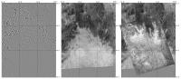
I've been searching for the locations of the Mars 3 images. There's a well-known one showing "mountains", which I had been completely unable to locate until recently. I thought I had it at the west edge of Argyre and told Ted that privately - but I think I was a bit off. Now I think I have it at the north edge of Argyre. Here's a comparison: Mars Viking mosaic from Map-A-Planet for the coordinates, then that map overlaid with one of the Mars 4 scanning camera images (see map I posted in another thread), and finally that map overlaid with the Mars 3 image. Look especially at the 42 S, 45 W area, which is what first suggested the site to me. Remember that - first, this is fiendishly difficult to do; second, no other even approximate match has been found so far, and third, albedo markings change over time. One point in support of this site is that it lies exactly on one of the three ground tracks for Mars 3 orbital remote sensing data previously published. But now consider this. It's the north edge of Argyre. It's right in the middle of the USGS map of Nereidum Montes that was (I think) made at the request of the Soviets for the Mars 6-7 landers (just as their Mare Erythraeum sheet is exactly centered on the Mars 6 target). So was it the Mars 7 target? I think a story is beginning to firm up here. The idea is not "Mars 3 imaged this as a future landing site", but "Since this had been imaged it became the Mars 7 target". Phil
-------------------- ... because the Solar System ain't gonna map itself.
Also to be found posting similar content on https://mastodon.social/@PhilStooke Maps for download (free PD: https://upload.wikimedia.org/wikipedia/comm...Cartography.pdf NOTE: everything created by me which I post on UMSF is considered to be in the public domain (NOT CC, public domain) |
|
|
|
|
|
|
May 7 2009, 12:13 AM
Post
#3
|
|
|
Member Group: Members Posts: 212 Joined: 19-July 05 Member No.: 442 |
QUOTE (Geert @ May 6 2009, 04:40 PM)  Sorry, this is a long post and only interesting for some weird space historians like myself ;-) What I have been trying to do is make sense of the landing site selections for the Soviet Mars 2, 3, 6 and 7 landers from a mathematical point of view. In other topics it has been shown that the Soviets used Mariner images to plan the landing sites, and a lot has been written on the technical aspects of these missions, but not much has been written about why a certain landing site was selected and which were the constraints on landing. Actually I'm finding this discussion quite interesting, getting inside the heads of the designers tells us why missions were carried out the way they were and gets behind the somewhat bland descriptions in the history books. Anyway, before this thread gets any longer I thought I'd link through to the other two Soviet Mars mission threads so people can find the earlier discussions. 1. Mars 3 Problem 2. Soviet Imagery from the "Mars" Series |
|
|
|
|
May 7 2009, 01:55 AM
Post
#4
|
|
|
Member Group: Members Posts: 236 Joined: 5-June 08 From: Udon Thani Member No.: 4185 |
QUOTE (Phil Stooke @ May 6 2009, 11:33 PM) Look especially at the 42 S, 45 W area, which is what first suggested the site to me. ... I think a story is beginning to firm up here. The idea is not "Mars 3 imaged this as a future landing site", but "Since this had been imaged it became the Mars 7 target". Amazing work Phil! I have indeed often wondered which area was depicted by that Mars 3 image and it seemed to me almost impossible to find out, this must have been a LOT of work for you to match, thanks a lot for sharing this info. I agree with you that it looks like they selected sites based on existing images, your earlier remarks regarding the match between Mars 2/3 sites and mariner images makes this also very clear. I wouldn't be surprised if you find a similar match for the Mars 6 landing site (I wonder whether all Mars 3 images have been published, Don Mitchell has only a few on his site and if he couldn't find more then I'm not even going to try). Somewhere hidden deep within the archives must (hopefully) be the true data-tapes of all Soviet mars images, that would be interesting as all we have now are scans of badly printed newspaper images and the true quality was probably a lot better (as Don Mitchell already showed earlier with the Venus images). Regarding Mars 3 I still have the impression that the planned landing site should be more to the east, inside that crater instead of just outside, that would also match it better with the Mariner 4 image. I always have some doubts about those coordinates, given the fact that the Soviets had only very inaccurate ephemeris of Mars during the M71 mission an error in longitude is easily explained. Also there have been several changes in coordinate-system for Mars and I'm unsure which system the Soviets used. Regarding Mars 7 its intended landing site remains a mysterie. I have been searching for the true source of those 50S 28W coordinates and so far have found nothing, Perminov definitely doesn't mention it in his booklet which is a pity as he is one of the prime witnesses. For the time being I stick to the opinion that they originally planned to land Mars 7 on the north edge of Argyre, as you show, and then had to change this selection in flight after the failure of the Mars 4 relay to enter orbit. But even then I wonder why it should be at 50S, that doesn't make sense. A "last minute" change in pre-programmed landing site could explain the mention "the command to separate the lander" for Mars 7 (Ulivi/Harland, part 1, page 165) as according Perminov there were two modes: one fully automatic (used by Mars 2,3 and 6) and one under ground control, if Mars 7 was re-directed to an alternative site it might be that it attempted to land under ground control (at least as far as separation of the lander, which determined the location of the site). I wish there was more accurate orbital ephemeris data for those missions, that would explain a lot. |
|
|
|
|
May 7 2009, 02:58 AM
Post
#5
|
|
|
Newbie Group: Members Posts: 6 Joined: 21-April 09 From: Oktemtsy, Russia Member No.: 4747 |
 Very interesting! Thank you very much! I have posted your message at a forum of a site of Novosti kosmonavtiki magazine, here the link . There is a similar message. Very interesting! Thank you very much! I have posted your message at a forum of a site of Novosti kosmonavtiki magazine, here the link . There is a similar message.
|
|
|
|
|
May 7 2009, 10:55 AM
Post
#6
|
|
|
Member Group: Members Posts: 378 Joined: 21-April 05 From: Portugal Member No.: 347 |
Phil,
Excelent detective work. The general area does seem right. Anyway, I looked closely at the images and got curious about some things. Are you certain about the Mars3 image orientation and scale? Any data about the geometry? It's possible that it was printed reversed (I've seen some Pioneer 11 Saturn images that look reversed, for example)? By looking at the same area, there are other possible matches IF we invert or stretch the image a little. Also, there are 3 round markings on the image that look to me as craters, and perhaps some possible matches could be found. -------------------- _______________________
www.astrosurf.com/nunes |
|
|
|
|
May 7 2009, 11:01 AM
Post
#7
|
|
|
Solar System Cartographer Group: Members Posts: 10151 Joined: 5-April 05 From: Canada Member No.: 227 |
Hi - I've tried many alternatives, but if anyone wants to suggest others I would be happy to consider them. Scale and orientation are possibly not correct, and reversal is possible as well. Completely different areas on Mars are possible too. I initially thought this might be the tributary canyons on the south edge of Valles Marineris, but I couldn't find a match. The number of unknowns is what makes this so hard.
Phil -------------------- ... because the Solar System ain't gonna map itself.
Also to be found posting similar content on https://mastodon.social/@PhilStooke Maps for download (free PD: https://upload.wikimedia.org/wikipedia/comm...Cartography.pdf NOTE: everything created by me which I post on UMSF is considered to be in the public domain (NOT CC, public domain) |
|
|
|
|
May 7 2009, 12:41 PM
Post
#8
|
|
|
Member Group: Members Posts: 236 Joined: 5-June 08 From: Udon Thani Member No.: 4185 |
QUOTE (Phil Stooke @ May 7 2009, 06:01 PM) The number of unknowns is what makes this so hard. Maybe the number of unknowns can be a little reduced if we assume the image was made close to periapsis, which for Mars 3 means somewhere near 48S. I guess any location on the northern hemisphere is very unlikely given the very elongated orbit of Mars 3. The northern edge of Argyre would fit perfectly with the orbital data. |
|
|
|
|
May 7 2009, 12:53 PM
Post
#9
|
|
|
Solar System Cartographer Group: Members Posts: 10151 Joined: 5-April 05 From: Canada Member No.: 227 |
Mars 3 took several crescent views - which Ted knows well. Those were taken up near apoapsis, looking down on the northern terminator. Chikmachev published a paper in which he describes projecting them on a globe (like the National Geographic Society when they made their well known lunar map, and like Whitaker and co doing limb reprojections), and he shows one example. The crescent image with the most obvious albedo/cloud features turns out to be looking down from the north onto Tempe, with Mare Acidalium and Alba also visible. I have made a composite map showing the extent of this image, the three remote sensing ground tracks, and my two image identifications. I'll post it soon. This is an example of work for my Atlas of Mars Exploration proposal, which this week was approved by Cambridge University Press.
Phil -------------------- ... because the Solar System ain't gonna map itself.
Also to be found posting similar content on https://mastodon.social/@PhilStooke Maps for download (free PD: https://upload.wikimedia.org/wikipedia/comm...Cartography.pdf NOTE: everything created by me which I post on UMSF is considered to be in the public domain (NOT CC, public domain) |
|
|
|
|
May 8 2009, 09:52 AM
Post
#10
|
||||
|
Member Group: Members Posts: 236 Joined: 5-June 08 From: Udon Thani Member No.: 4185 |
I have been working on trying to calculate the communication windows for the M73 landers, and for Mars 6 this seems to work out quite nicely.
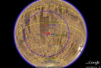
Above image shows my calculated position for the Mars 5 relay orbiter at the moment of Mars 6 landing, as can be seen Mars 5 is slightly south of the lander but almost right overhead and far above the horizon. After landing there should have been about 14-15 minutes of communication window remaining via Mars 5, that is IF Mars 5 had not failed earlier and IF Mars 6 had survived touch down. For Mars 7 the situation is more complicated as there is a lot of contradictory information in times etc. For Mars 7 I assumed two landing constraints: 1) Landing required in local afternoon, abt 1500 LMT 2) Mars 5 orbiter above horizon during landing However, I can't get these two constraints to match for March 09, 1974. In order to land in a similar situation as Mars 6 with regards to the Mars 5 orbiter, the Mars 7 lander would have to land at night, which does not seem likely to me. If you assume a landing in the local afternoon, I can't get it to match the groundtrack of Mars 5.
Above is the situation for a landing at 1500 LMT at 43 S 42 W. As can be seen the Mars 5 orbiter is nowhere near the landingsite and well below the horizon.
This is the same situation for a landing at 1500 LMT at 50 S 28W, In this case Mars 5 is slightly closer, but still below the horizon. Once again, to match the lander with the orbiter, the lander would have to land at night or it would have to land far to the north which probably was not within reach of the flyby trajectory. Offcourse, the lander might have relayed the info one sol late, when the orbiter passed just above the horizon but it doesn't look like there was a nice match as with Mars 6. I do have to note however that these calculations are very much 'back of the envellope', there does not seem to be any accurate enough ephemeris data on the Mars 5 orbit, so I had to make do with what is available and the calculated Mars 5 position might be off by 10 or 20 degrees, but even then it doesn't match either of the mentioned landing positions... |
|||
|
|
|
|||
|
May 14 2009, 03:35 PM
Post
#11
|
|
|
Solar System Cartographer Group: Members Posts: 10151 Joined: 5-April 05 From: Canada Member No.: 227 |
Flash of insight as I prepared a map. The 50S, 28W location is a simple mistake caused by confusion between the craters Hooke and Galle. The site in northern Argyre was just outside the NE rim of Hooke, and somebody plotting it on a map accidentaly placed it off the NE rim of Galle. I've seen this kind of mistake many times.
I'm not 100% certain of my location for the Mars 3 image but it has to be roughly at that location. Phil Stooke -------------------- ... because the Solar System ain't gonna map itself.
Also to be found posting similar content on https://mastodon.social/@PhilStooke Maps for download (free PD: https://upload.wikimedia.org/wikipedia/comm...Cartography.pdf NOTE: everything created by me which I post on UMSF is considered to be in the public domain (NOT CC, public domain) |
|
|
|
|

|
Lo-Fi Version | Time is now: 25th April 2024 - 06:37 AM |
|
RULES AND GUIDELINES Please read the Forum Rules and Guidelines before posting. IMAGE COPYRIGHT |
OPINIONS AND MODERATION Opinions expressed on UnmannedSpaceflight.com are those of the individual posters and do not necessarily reflect the opinions of UnmannedSpaceflight.com or The Planetary Society. The all-volunteer UnmannedSpaceflight.com moderation team is wholly independent of The Planetary Society. The Planetary Society has no influence over decisions made by the UnmannedSpaceflight.com moderators. |
SUPPORT THE FORUM Unmannedspaceflight.com is funded by the Planetary Society. Please consider supporting our work and many other projects by donating to the Society or becoming a member. |
|